





Weekly Weather Watch: Monday, March 24th, 2025
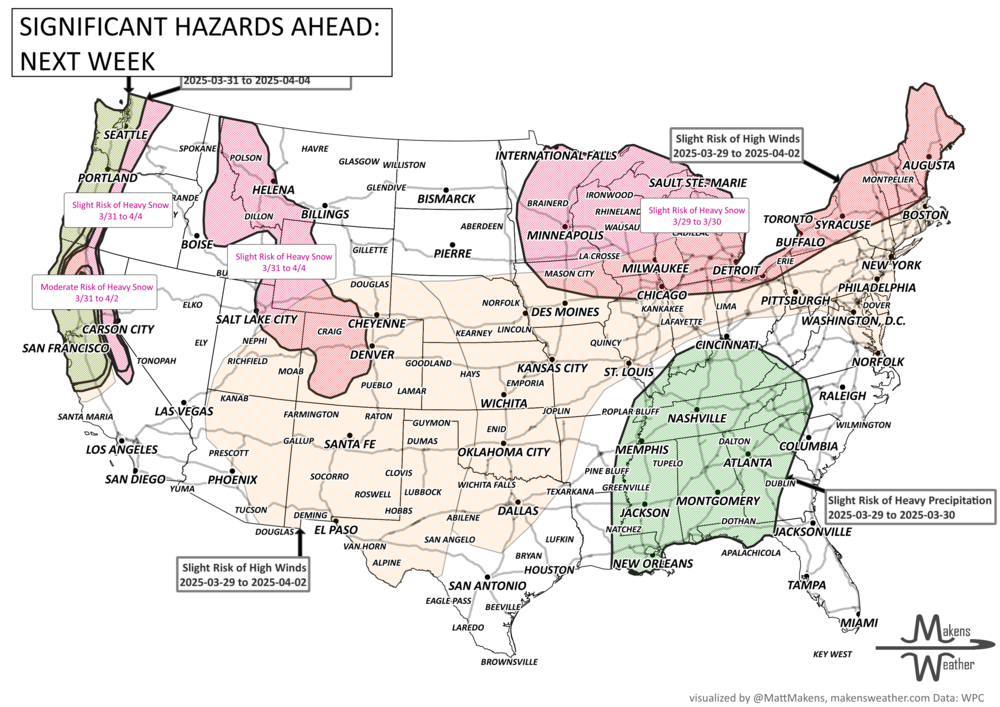
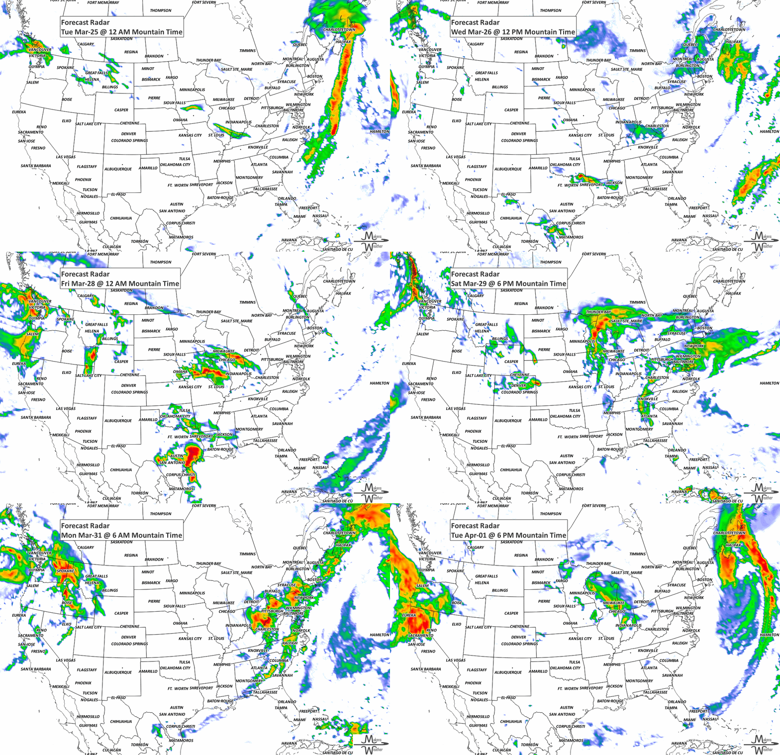
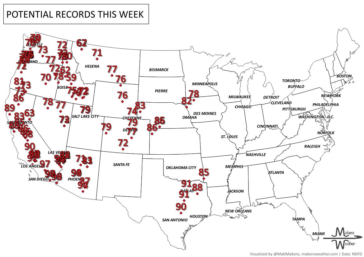
In this Weekly Weather Watch, the headlines coming your way include: The Pacific Northwest remains soggy as moisture streaming into the region brings steady rain in lower elevations and heavy snow in the northern Cascades and Rockies. Meanwhile, severe thunderstorms threaten the Gulf Coast from Louisiana to Georgia. Looking for warmth? Spring-like temperatures are expanding across the western and central U.S. this week where record-high temperatures will be set in dozens of locations. Looking for snow? Head to Canada, where heavy snow will cover many.
Members, your weekly breakouts arrived in your emails this morning. Holler at me if that didn’t come.
HEADLINERS:
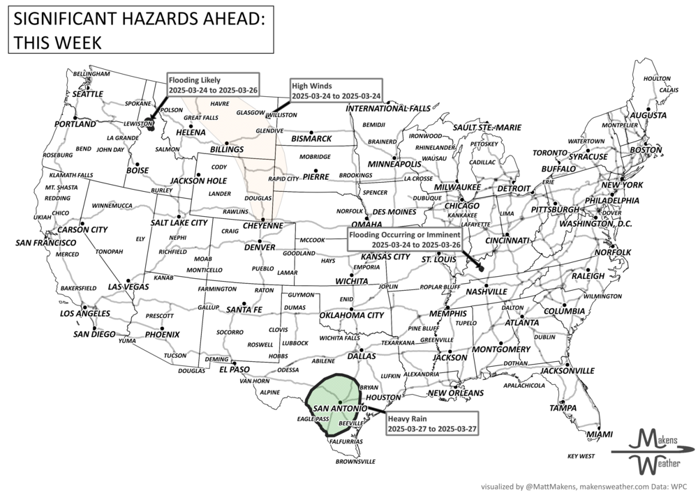
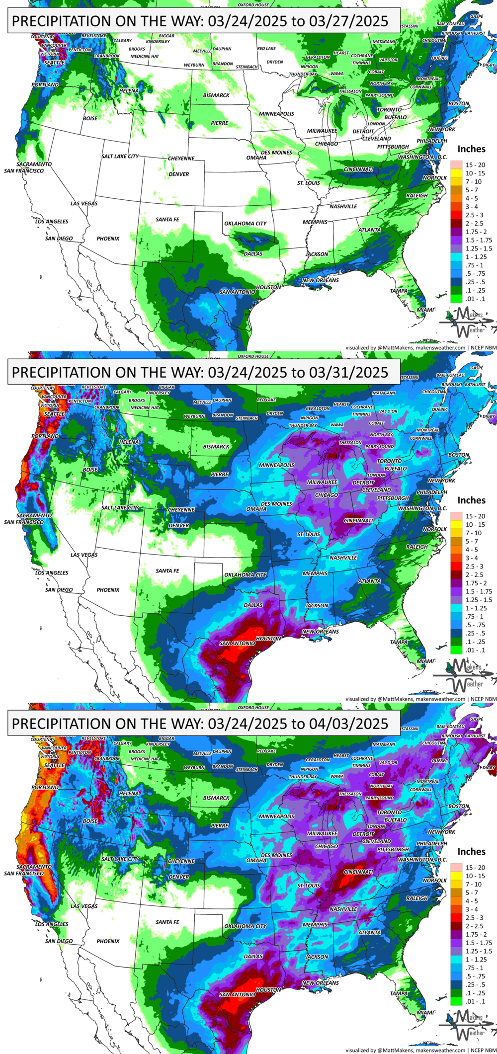
Moderate risk of episodic heavy precipitation across parts of southwestern Oregon and northern and central California, Mon-Wed, Mar 31-Apr 2.
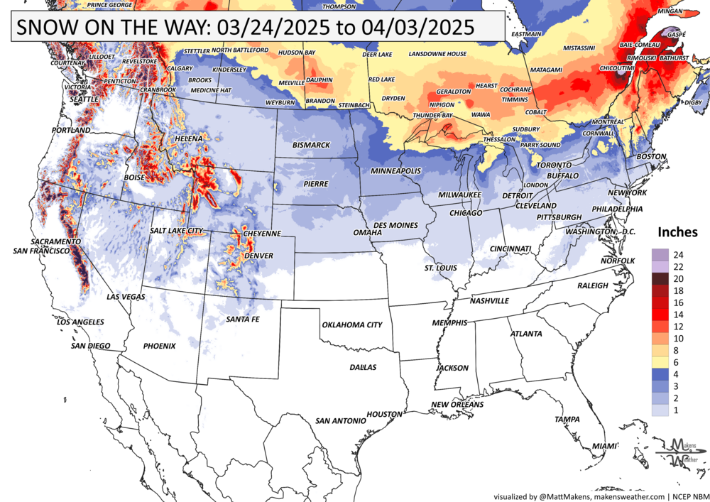
Moderate risk of episodic heavy snow across the southern Cascades, Klamath, and Sierra Nevada Mountains, Mon-Wed, Mar 31-Apr 2.
Slight risk of heavy precipitation for parts of the Lower Mississippi, Ohio, and Tennessee Valleys, Southern Appalachians, and Southeast U.S., Sat-Sun, Mar 29-30.
Slight risk of episodic heavy precipitation across parts of the West Coast, Mon-Fri, Mar 31-Apr 4.
Slight risk of episodic heavy snow across the Cascades, Klamath, and Sierra Nevada Mountains, Mon-Fri, Mar 31-Apr 4.
Slight risk of heavy snow across parts of the Upper Midwest, Great Lakes, and Northeast, Sat-Sun, Mar 29-30.
Slight risk of periods of heavy snow for much of the Northern and Central Rockies, Mon-Fri, Mar 31-Apr 4.
Slight risk of periods of high winds across parts of the West Coast, Sat-Fri, Mar 29-Apr 4.
Slight risk of periods of high winds across parts of the Four Corners region, Central and Southern Plains, and Colorado, Sat-Wed, Mar 29-Apr 2.
Slight risk of episodic high winds across portions of the Central and Southern Plains, Middle and Upper Mississippi, and Ohio Valleys, Great Lakes region, Mid-Atlantic, and Northeast, Sat-Wed, Mar 29-Apr 2.
Risk of Rapid Onset Drought for portions of the Southern Plains - West Texas and East New Mexico.
List via NOAA’s WPC.
ON THE RADAR:
KEEP AN EYE TO THE SKY:
IN THE GAUGES:
GRAB A RULER:
RECORDS MADE TO BE BROKEN:
ARE YOU CIRRUS?!
On this day in history:
1957 Snow drifts piled up to 14 feet in the area around Amarillo, TX.
1975 In Atlanta, GA an F3 tornado hit the Governor's Mansion causing considerable damage. 3 people were killed and 152 were injured.
BURNING QUESTIONS:
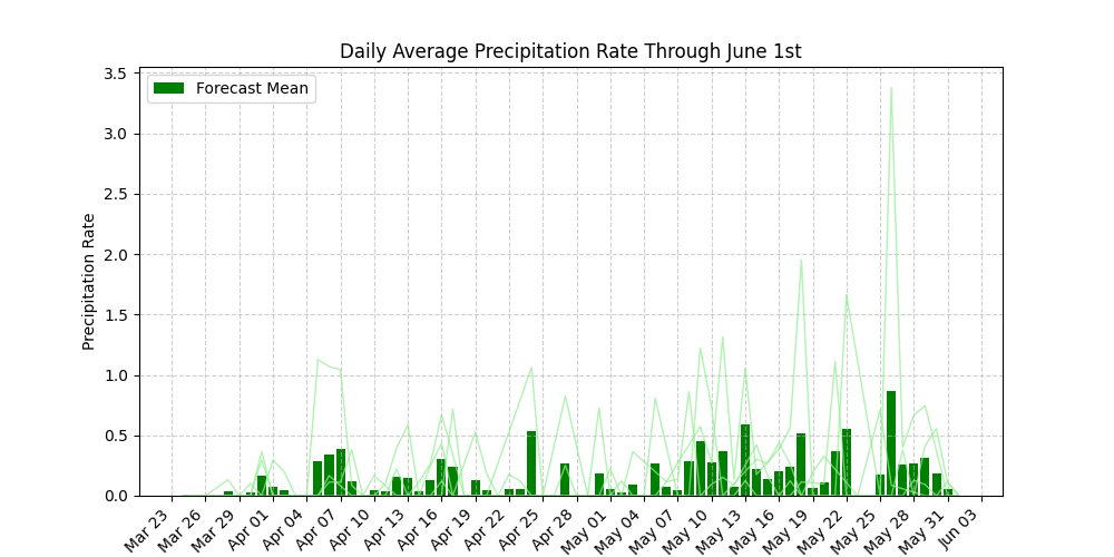
Many clients have asked about prescribed burn planning for this spring. The problem: wind and needing precipitation and soil moisture to cooperate after a burn. Here’s an example of the projections they’ve been receiving as they plan burn opportunities or to cancel those plans this year.
The weather pattern is about to make a pretty sharp turn across the country. California starts the week with unusual October heat, including highs well into the 90s and even lower 100s in the Central Valley. Meanwhile, much cooler fall air has reached the Great Lakes and Northeast. The Gulf Coast and Southeast stay unsettled, and there’s that record to watch: a tropical depression is likely to develop over the Gulf this week and could strengthen as it moves northeast. If it becomes a hurricane after the 8th, 2026 will have the latest-first hurricane in the Atlantic Basin record.