





Weekly Weather Watch: Tuesday, April 22nd, 2025
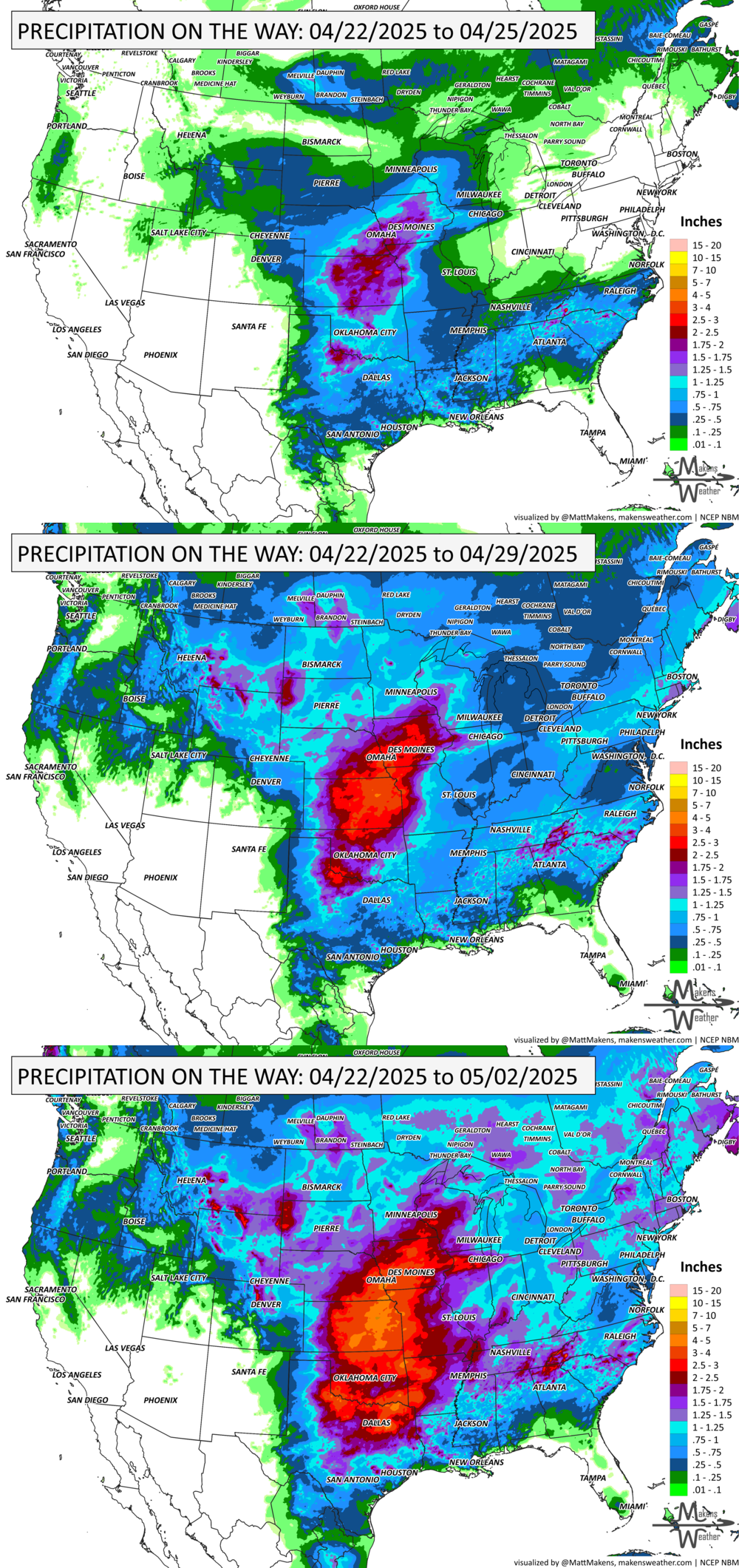
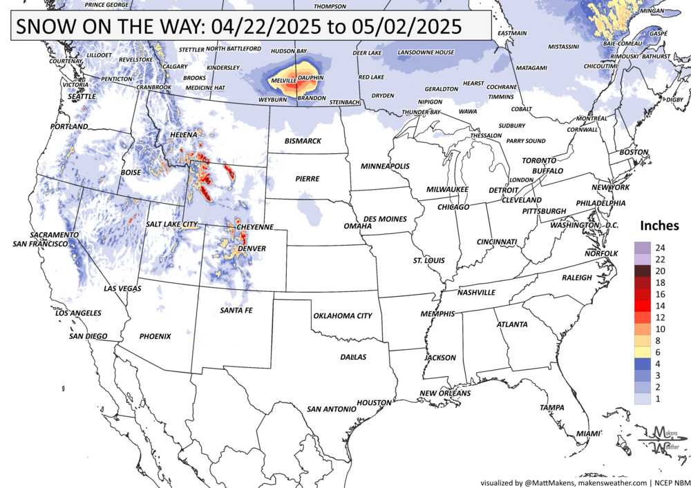
Hey weather watchers, here’s your briefing - The Weekly Weather Watch. A lot is happening across the U.S. & Canada this week. Showers and thunderstorms are expected to linger across the South over the next couple of days as a trailing front stalls in the region. Isolated severe storms could bring large hail, strong wind gusts, and heavy rain, particularly in the southern Plains. This weather system will gradually spread eastward, with widespread thunderstorms and heavy rain moving into the east-central and northeastern U.S. later this week. At the same time, an upper-level trough moving across the West will bring moderate precipitation to the Northwest, including snow at higher elevations in the north-central Rockies. This unsettled weather will continue to increase rain and thunderstorm chances across the central U.S. into the weekend. Meanwhile, snowfall warnings cover parts of central Canada.
Members, your weekly outlooks arrived Monday, showing the frequent moisture to hit the central U.S. in particular.
HEADLINERS:
Snowfall warning, with total amounts of 10 to 20 cm, is expected for parts of eastern Saskatchewan and western Manitoba.
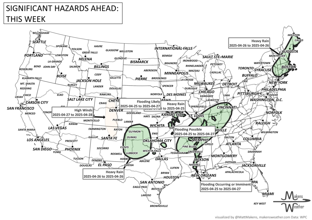
There is a risk of severe thunderstorms over parts of the Central/Southern Plains on Tuesday and the Southern Plains on Wednesday.
Slight risk of heavy precipitation for portions of the Central and Southern Plains and the Middle and Lower Mississippi, Tennessee, and Ohio Valleys, Tue-Wed, Apr 29-30.
Slight risk of high winds over portions of the Northern Plains, Upper Mississippi Valley, and Great Lakes, Tue-Wed, Apr 29-30.
Possible flooding for the Lower Mississippi River.
List via NOAA’s WPC.
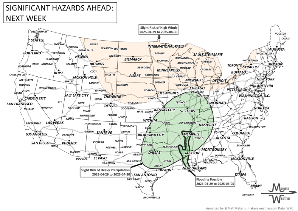
ON THE RADAR:
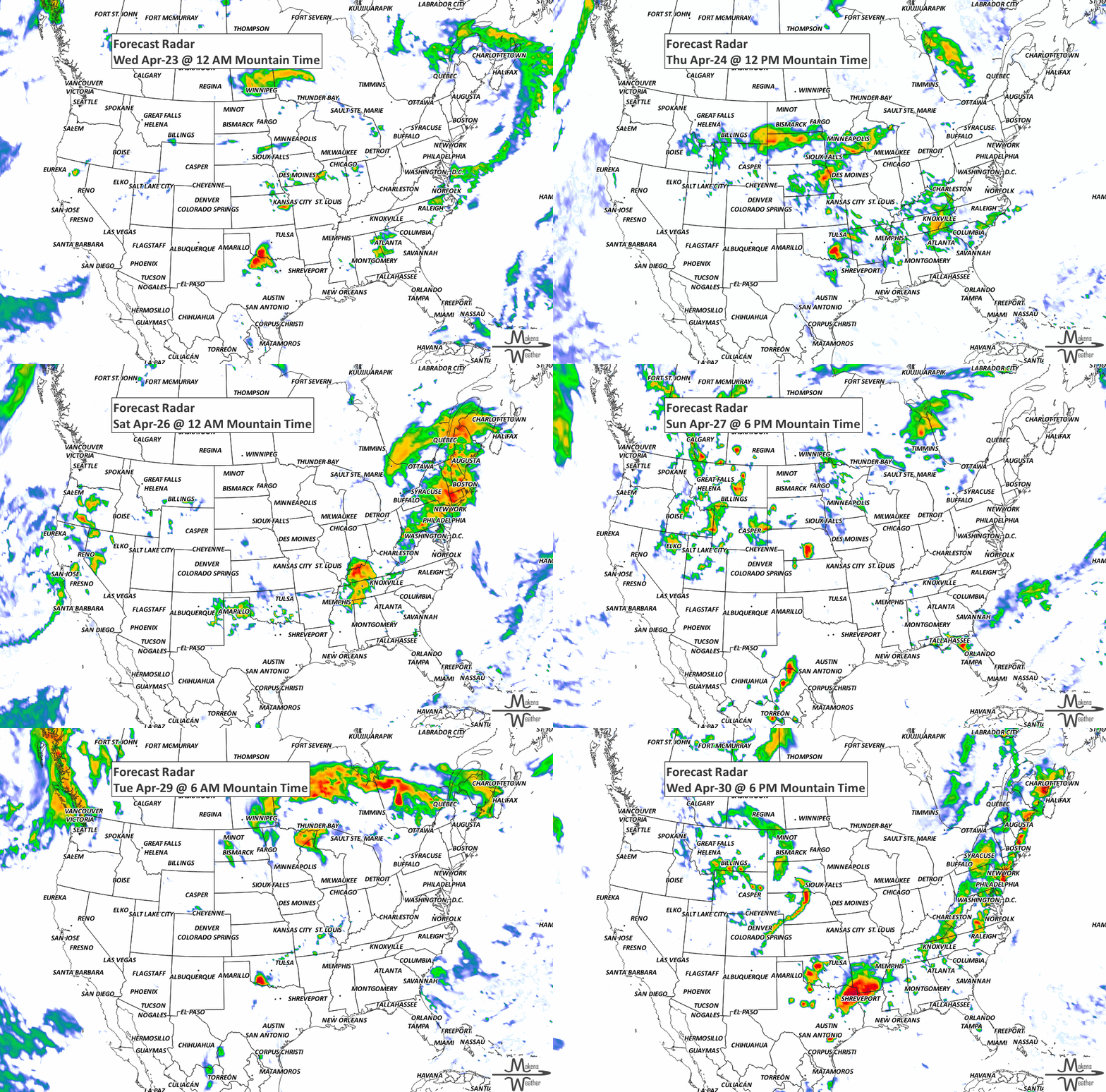
KEEP AN EYE TO THE SKY:
IN THE GAUGES:
GRAB A RULER:
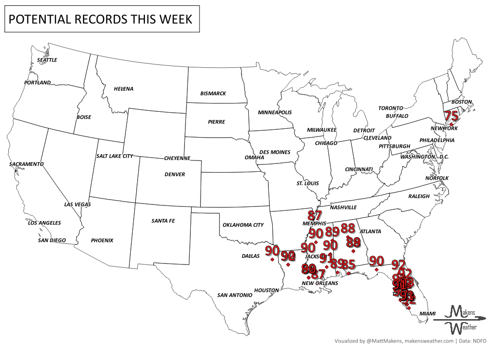
RECORDS MADE TO BE BROKEN:
ARE YOU CIRRUS?!
1932: In Elgin, Manitoba, 52 wild geese were struck by lightning in flight and killed.
SPRING GROWTH:
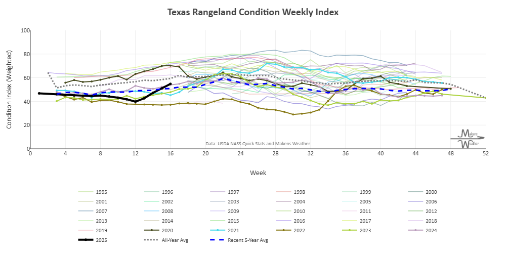
It’s spring, the season of greener grass. In some cases, the grass is a lot greener on the other side of the fence…errr, country. The latest rangeland conditions were updated last night. Here’s an example for Texas with a historic perspective. These charts are available in the members section.
The weather pattern is about to make a pretty sharp turn across the country. California starts the week with unusual October heat, including highs well into the 90s and even lower 100s in the Central Valley. Meanwhile, much cooler fall air has reached the Great Lakes and Northeast. The Gulf Coast and Southeast stay unsettled, and there’s that record to watch: a tropical depression is likely to develop over the Gulf this week and could strengthen as it moves northeast. If it becomes a hurricane after the 8th, 2026 will have the latest-first hurricane in the Atlantic Basin record.