





Weekly Weather Watch: Tuesday, March 17th, 2026
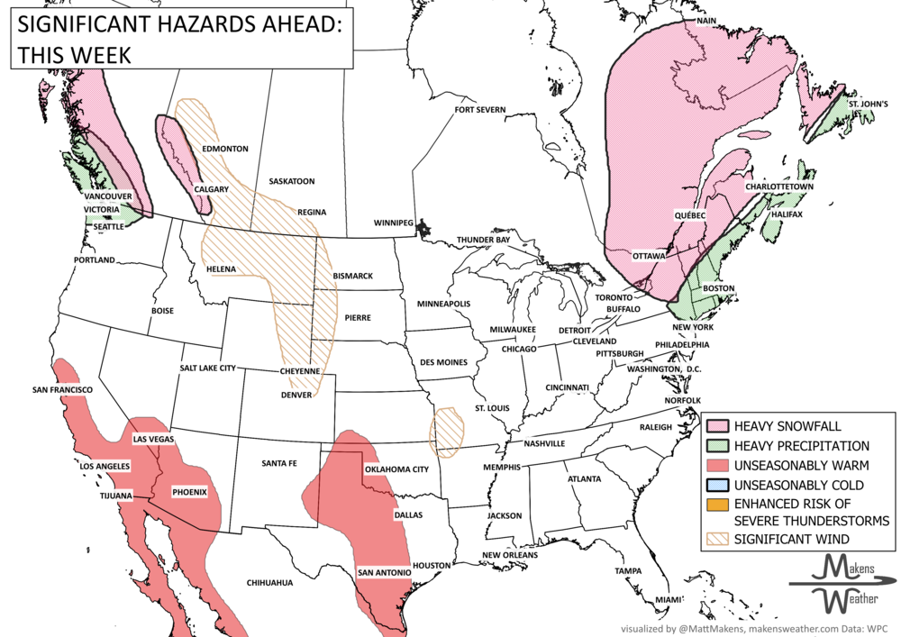
An unusually early taste of summer is taking hold across the western U.S., with dangerous heat building through the Southwest and spreading into parts of the Plains over the next several days. While the biggest headline is the expanding heat, elevated to critical fire weather conditions will also raise concerns across the High Plains and southern Plains. Elsewhere, the Pacific Northwest, British Columbia, and Alberta’s mountains stay wet for a bit longer, and the East remains stuck in a cooler, unsettled pattern with occasional rain and snow before conditions gradually settle.
Unlock the Makens Weather Advantage ☀️📊
Your membership includes:
✔️ Real-time dashboard with the latest weather observations and long-range projections
✔️ Monthly-lead forecasts to plan weeks ahead
✔️ Discounts on personalized consultations for ag, energy, or risk planning
All built for decision-makers who need weather insight, not just data.
🎯 Join now and put the forecast to work for you.
📈 The latest outlooks and conditions - track it 👉 Join Now to Access the Dashboard
HEADLINERS:
WHAT TO WATCH:
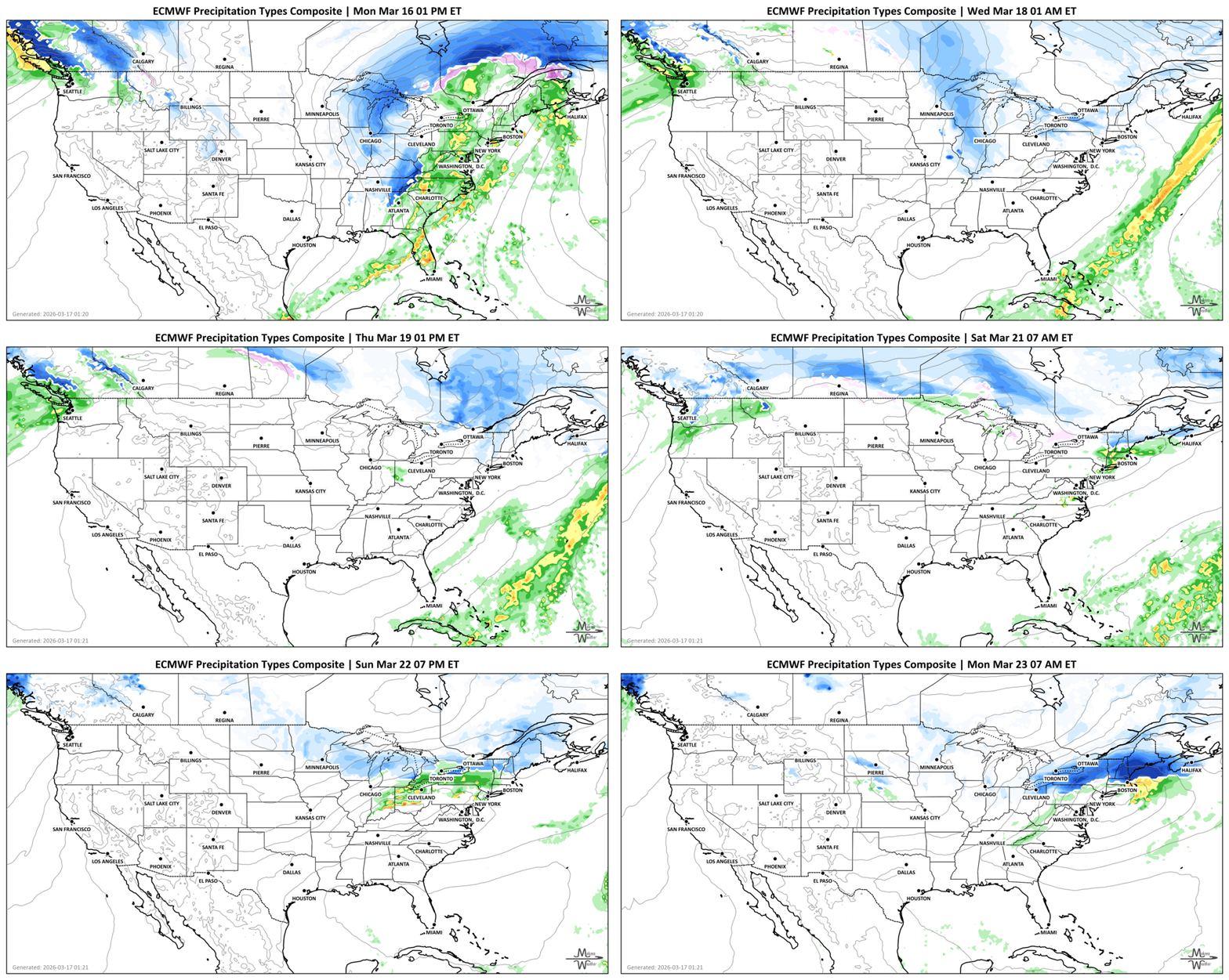
Tuesday: Dangerous heat begins ramping up across Southern California and the Desert Southwest, while critical fire weather concerns peak over the High Plains and southern Plains. Strong winds continue across New England. In Alberta, Strong winds with gusts up to 90 km/h are likely today. In British Columbia, heavy rainfall for the coastal areas and mountains. Winter storm alerts cover Quebec and the Maritimes.
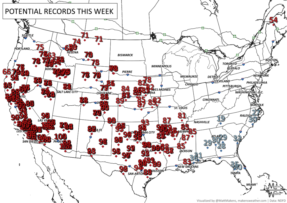
Wednesday: The heat expands farther east across the Southwest and into parts of the Great Basin, with record highs likely. Record morning cold may still reach parts of the Southeast. Gusty wind remains in Alberta to Montana
Thursday: Summerlike warmth spreads into more of the Intermountain West and starts building toward the central and southern Plains. Wet weather continues in western Washington with mountain snow in the Cascades and northern Rockies.
Friday: The heat wave remains intense across Arizona, southeastern California, and nearby desert locations, while moderate to heavy rain continues over western Washington.
Saturday: Very warm to hot weather expands across the central Plains and southern Plains, while the Pacific Northwest begins to dry out.
Sunday: Peak heat continues across the Southwest and southern Plains, with some areas still running far above normal for March. Fire weather concerns may remain elevated where vegetation is dry.
Monday: The most extreme heat begins to ease slightly in the Southwest, but temperatures remain well above average across much of the West and parts of the Plains. The Great Lakes, Northeast, and Mid-Atlantic may still see bouts of unsettled weather.
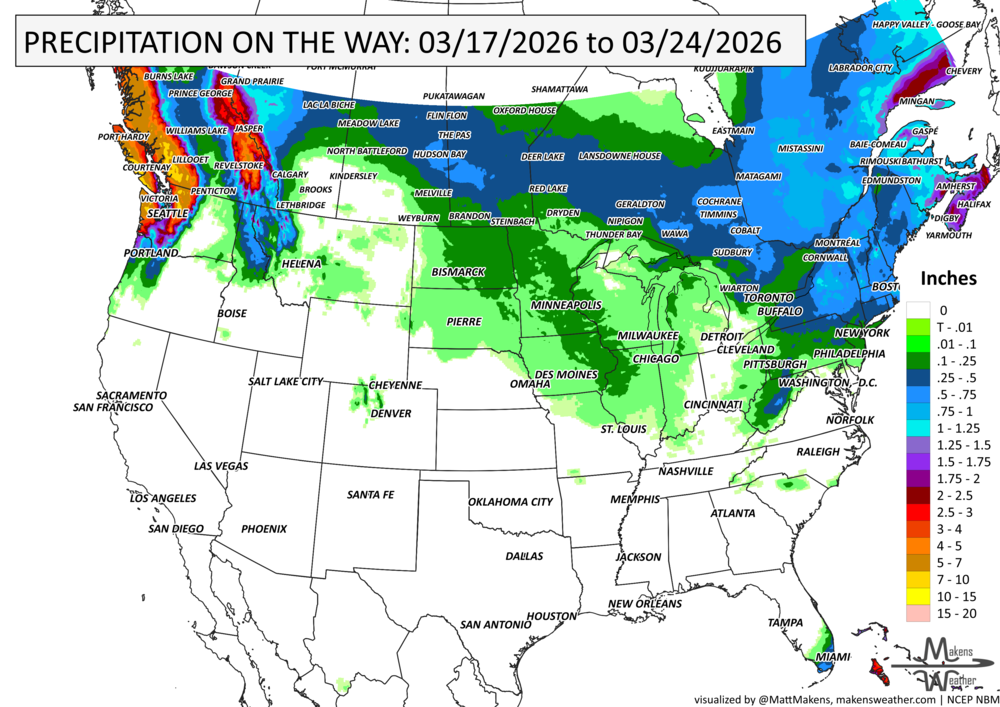
IN THE GAUGES, PRECIPITATION THROUGH THE 24th:
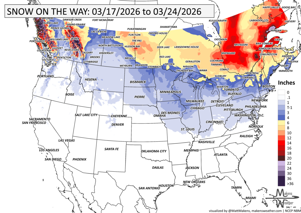
GRAB A RULER, SNOWFALL THROUGH THE 24th:
RECORDS MADE TO BE BROKEN, DAILY HIGHS (RED) | DAILY LOWS (BLUE):
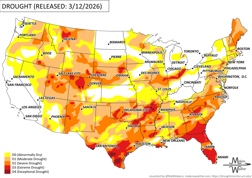
UN-DROUGHTABLY DRY:
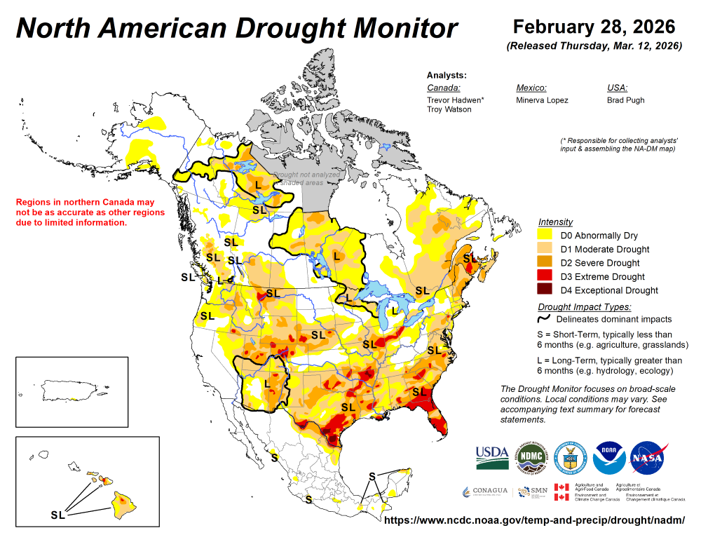
Following a drier-than-normal winter, a pattern change at the beginning of March resulted in widespread heavy precipitation (1 to 3 inches, locally more) and a 1-category improvement to parts of the Ohio and Middle to Lower Mississippi Valley. This drought improvement extended east to the Central Appalachians and the Northeast. However, a long-term drought continues for much of the Northeast. Despite the much-needed rainfall for portions of the Southeast and Southern Great Plains, severe (D2) to extreme (D3) drought persists for many areas. A low snowpack and early onset of snowmelt are a major drought concern for the West. As of March 10, drought of varying intensity was designated for parts of Hawaii. Alaska and Puerto Rico remain drought-free.
-The U.S. Drought Monitor is produced through a partnership between the National Drought Mitigation Center at the University of Nebraska-Lincoln, the United States Department of Agriculture, the National Oceanic and Atmospheric Administration and the National Aeronautics and Space Administration.
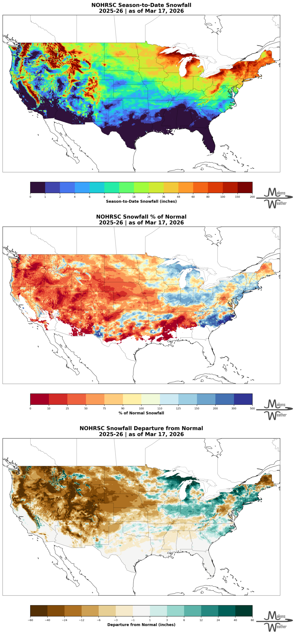
DIG DEEPER: U.S. SEASON SNOWFALL TO DATE (THIS DATA DOMAIN FOR THE CONTIGUOUS U.S. ONLY AT THIS TIME)
ARE YOU CIRRUS?!
Today in weather history:
2002 Normally protected from heavy snowfalls by mountains, Anchorage, AK picked up a record-setting 25.7 inches of snow in 24 hours.
1892 A winter storm in southwest and middle Tennessee produced 26 inches of snow in Riddleton and 18.5 inches in Memphis, setting the record for the city for deepest snowfall. Nashville recorded its greatest one-day snowfall of 17 inches.
The weather pattern is about to make a pretty sharp turn across the country. California starts the week with unusual October heat, including highs well into the 90s and even lower 100s in the Central Valley. Meanwhile, much cooler fall air has reached the Great Lakes and Northeast. The Gulf Coast and Southeast stay unsettled, and there’s that record to watch: a tropical depression is likely to develop over the Gulf this week and could strengthen as it moves northeast. If it becomes a hurricane after the 8th, 2026 will have the latest-first hurricane in the Atlantic Basin record.