





Weekly Weather Watch: Tuesday, March 24th, 2026
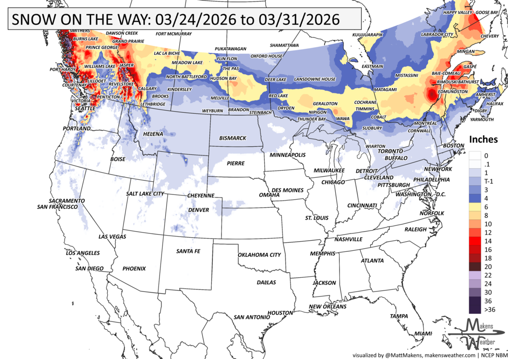
A big split in the weather pattern will drive the story during the next week. Early-season heat will continue across parts of the Southwest, Plains, and Mississippi Valley, with some areas running more like late spring than late March. At the same time, a strong cold front will sweep across the northern half of the country, bringing rounds of rain, some mountain and northern-tier snow, a chance for strong to severe thunderstorms, and a sharp return to cooler air for the East. By early next week, warmth expands again from the West into the Plains, while increasing Pacific moisture may begin pushing back into the Southwest. Snowfall will be heaviest in mountainous British Columbia and Alberta.
A quick thank you to the Montana Bankers Association for having me speak at their meeting last week. I'm headed to Fort Worth to speak at the TSCRA convention this week - drought… when do we beat it?!
Unlock the Makens Weather Advantage ☀️📊
Your membership includes:
✔️ Real-time dashboard with the latest weather observations and long-range projections
✔️ Monthly-lead forecasts to plan weeks ahead
✔️ Discounts on personalized consultations for ag, energy, or risk planning
All built for decision-makers who need weather insight, not just data.
🎯 Join now and put the forecast to work for you.
📈 The latest outlooks and conditions - track it 👉 Join Now to Access the Dashboard
HEADLINERS:
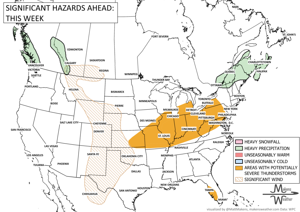
WHAT TO WATCH:
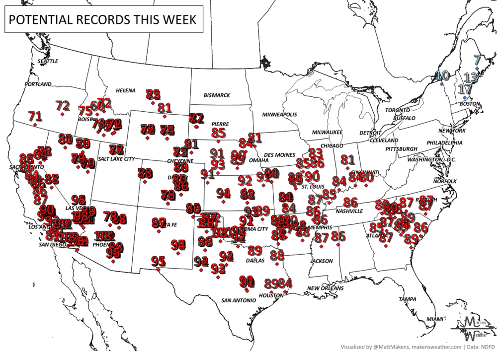
The headline through midweek is the unusual warmth spreading from the Intermountain West into the central U.S. Highs will surge well above normal, and some spots from Texas to the Ohio Valley could challenge record temperatures. The hottest day for many areas looks to be Wednesday, when the warmest air peaks over the Plains and nearby parts of the Mississippi Valley.
That warmth will not last everywhere. A strong cold front sliding south and east late week will bring a much different feel across the northern and eastern U.S. Rain will develop from parts of the Midwest into New England, with some light wintry weather possible on the colder side of the system. Strong to severe thunderstorms may also develop from the Mid-Mississippi Valley into the Ohio Valley on Thursday as the front presses through.
Looking into the weekend and early next week, cooler and drier air settles into much of the East, while the warm ridge rebuilds from the West into the Plains. The West may keep seeing unusually warm weather through the weekend before temperatures start to ease next week. At the same time, a new Pacific system could send more moisture into the Southwest, raising the chance for a more active pattern there by Sunday and beyond.
Next 7 Days: Key Timing and Impacts
Tuesday: Heat builds across the Southwest, High Plains, and parts of the central U.S., with temperatures climbing well above late-March averages.
Wednesday: Peak warmth likely from the Plains into the Mississippi Valley, with some record highs possible. Rain and mountain snow also begin to move into the Pacific Northwest.
Thursday: Strong to severe thunderstorms may develop from the Mid-Mississippi Valley into the Ohio Valley. Cooler air begins pushing south behind the front.
Thursday into Friday: Rain spreads from the Midwest to southern New England, with some light wintry weather possible on the colder side across parts of the northern tier and interior Northeast.
Friday: A sharp cooldown settles into much of the eastern U.S., with gusty northerly winds making it feel even colder.
Weekend: Warmth expands again across the West and into the Plains, while cooler, drier air holds across much of the East.
Sunday into early next week: Moisture may begin increasing into the Southwest, hinting at a more active pattern returning there.
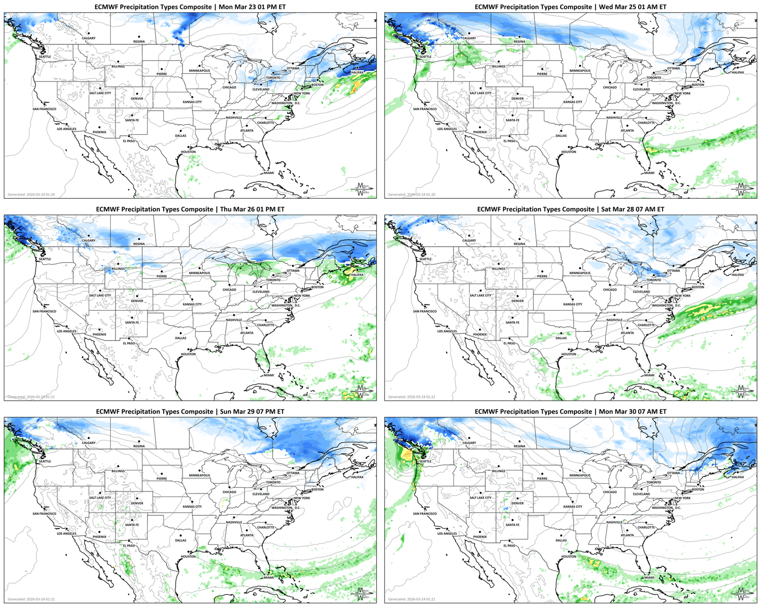
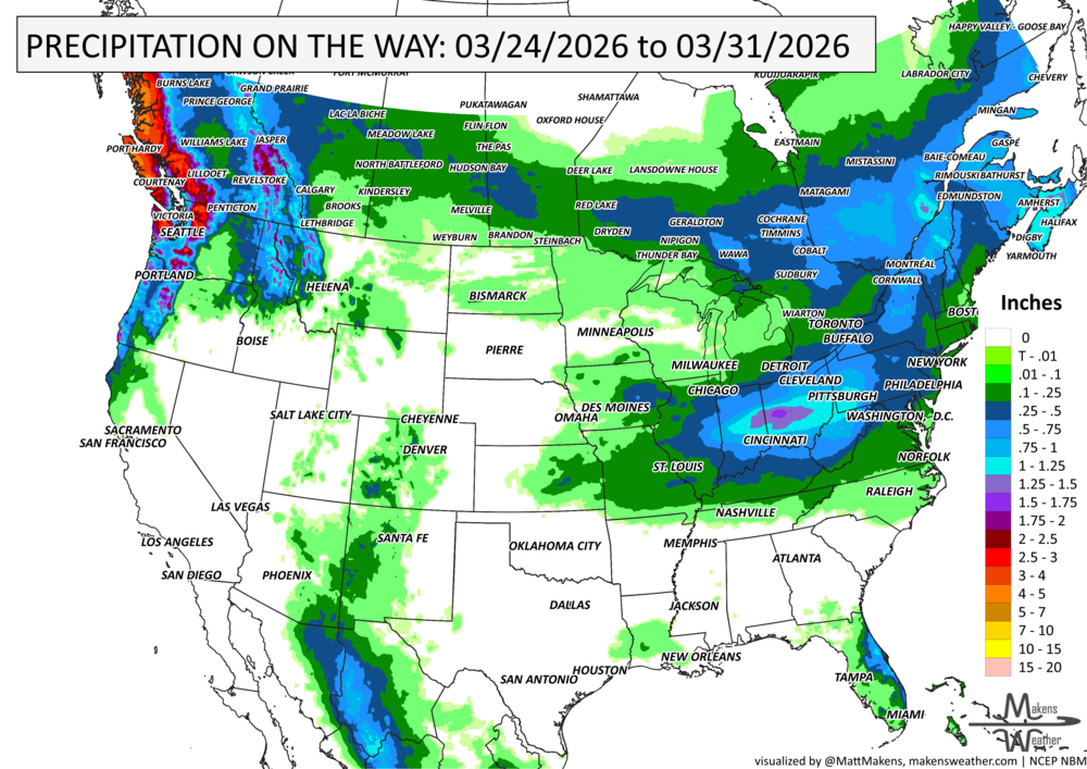
IN THE GAUGES, PRECIPITATION THROUGH THE 31st:
GRAB A RULER, SNOWFALL THROUGH THE 31st:
RECORDS MADE TO BE BROKEN, DAILY HIGHS (RED) | DAILY LOWS (BLUE):
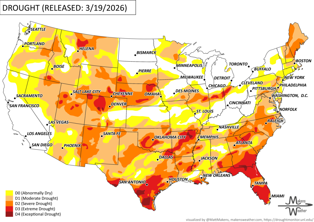
UN-DROUGHTABLY DRY:
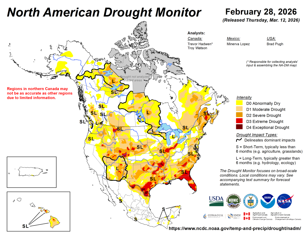
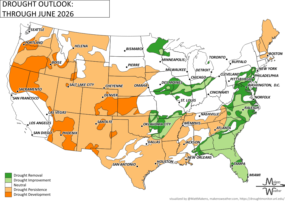
drought outlook:
ARE YOU CIRRUS?!
Today in weather history:
1957: Snowdrifts piled up to 14 feet in the area around Amarillo, TX.
1975 In Atlanta, GA, an F3 tornado hit the Governor's Mansion, causing considerable damage. 3 people were killed, and 152 were injured.
The weather pattern is about to make a pretty sharp turn across the country. California starts the week with unusual October heat, including highs well into the 90s and even lower 100s in the Central Valley. Meanwhile, much cooler fall air has reached the Great Lakes and Northeast. The Gulf Coast and Southeast stay unsettled, and there’s that record to watch: a tropical depression is likely to develop over the Gulf this week and could strengthen as it moves northeast. If it becomes a hurricane after the 8th, 2026 will have the latest-first hurricane in the Atlantic Basin record.