





Weekly Weather Watch: Tuesday, March 31st, 2026
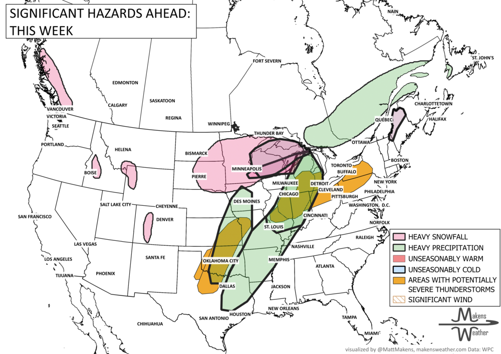
A drawn-out storm pattern will keep much of the country active through the first week of April. A slow-moving front stretching from the Great Lakes into the Plains will separate late-season snow and ice to the north from heavy rain and severe thunderstorms to the south. Quite a wintry mix is possible over southern Ontario and Quebec to the Maritimes. The setup brings the greatest impacts to parts of the Midwest, Ohio Valley, Southern Plains, Mississippi Valley, and eventually the East Coast, while the West sees mountain snow and then a warming trend heading into the weekend.
Unlock the Makens Weather Advantage ☀️📊
Your membership includes:
✔️ Real-time dashboard with the latest weather observations and long-range projections
✔️ Monthly-lead forecasts to plan weeks ahead
✔️ Discounts on personalized consultations for ag, energy, or risk planning
All built for decision-makers who need weather insight, not just data.
🎯 Join now and put the forecast to work for you.
📈 The latest outlooks and conditions - track it 👉 Join Now to Access the Dashboard
HEADLINERS:
Next 7 Days: Key Timing and Impacts
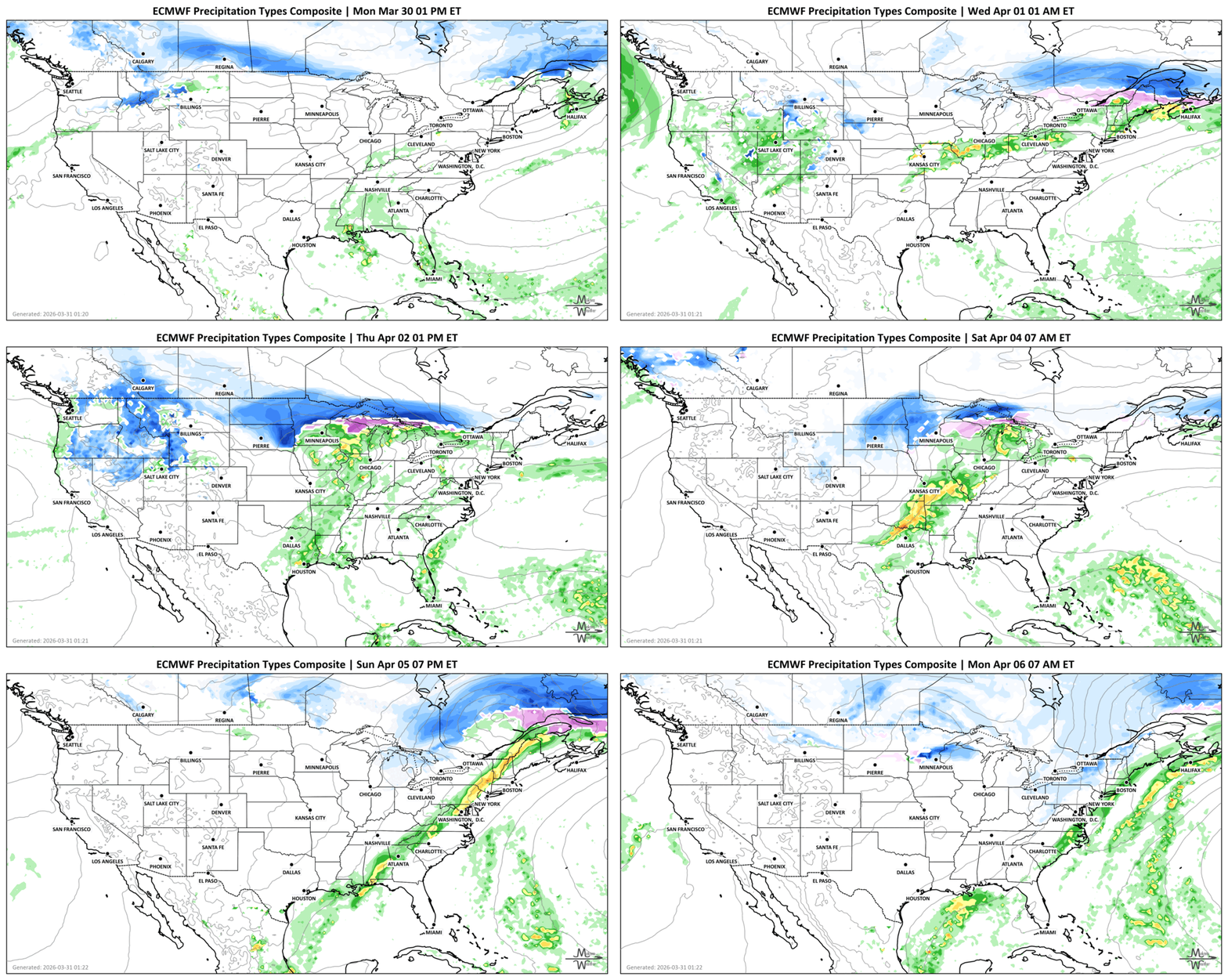
Tuesday, March 31: Severe thunderstorms target parts of the Great Lakes and Ohio Valley, with damaging wind, hail, heavy rain, and a few tornadoes possible.
Tuesday, March 31 into Wednesday, April 1: Rain, freezing rain, and some light snow spread from the Upper Mississippi Valley and Upper Great Lakes into parts of the Northeast.
Wednesday, April 1: Another severe weather zone sets up from the Central Plains and Middle Mississippi Valley into the Southern Plains, with strong thunderstorms capable of wind damage, hail, and isolated tornadoes.
Wednesday, April 1 into Thursday, April 2: Wintry pockets continue from the Central Plains to the Great Lakes, with another area of freezing rain and cold rain in parts of the Northeast.
Late week, Friday, April 3 into Saturday, April 4: Heavy rain and flooding concerns increase across the Southern Plains, especially Oklahoma, then expand east into the Mid-South, Ohio Valley, and Great Lakes.
Friday, April 3 into Saturday, April 4: Snow and ice remain possible across parts of the Northern Plains, Upper Midwest, Upper Great Lakes, and northern New England, including Maine.
Sunday, April 5 into Monday, April 6: The main front pushes to the East Coast, bringing widespread rain and thunderstorms, while cooler air settles into the central and eastern U.S.
This week in the West: Rain and higher-elevation snow affect the Pacific Northwest, Northern Rockies, Great Basin, Central Rockies, and Sierra Nevada before a warmer pattern develops over much of the West by the weekend.
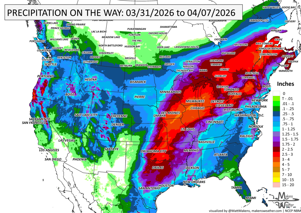
IN THE GAUGES, PRECIPITATION THROUGH THE 7th:
NOTE: FOR THE CENTRAL TO SOUTHERN US, THESE PROJECTED TOTALS ARE LIKELY TO BE OVERDONE FOR MANY AREAS BECAUSE THUNDERSTORMS WILL BE THE SOURCE OF RAINFALL, AND WE KNOW THAT THUNDERSTORMS MAY BE FAR APART, ESPECIALLY OVER OKLAHOMA AND TEXAS. SO, THESE TYPES OF PROJECTIONS FOR THUNDERSTORM AREAS REFLECT A POTENTIAL RAINFALL TOTAL, IF YOU GET THE STORMS TO PASS OVER YOU. THE ACTUAL OBSERVATIONS WILL BE MORE ISOLATED TOTALS TO THESE MAGNITUDES SOUTH OF I-70 OR SO.
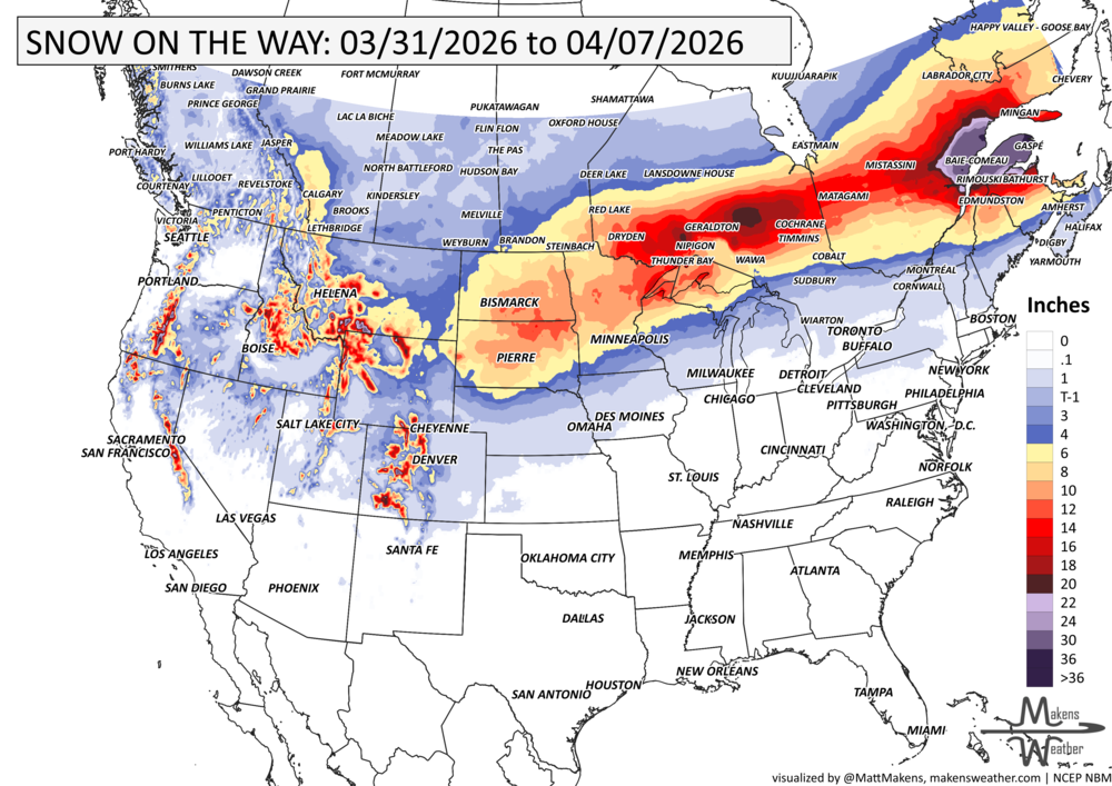
GRAB A RULER, SNOWFALL THROUGH THE 7TH:
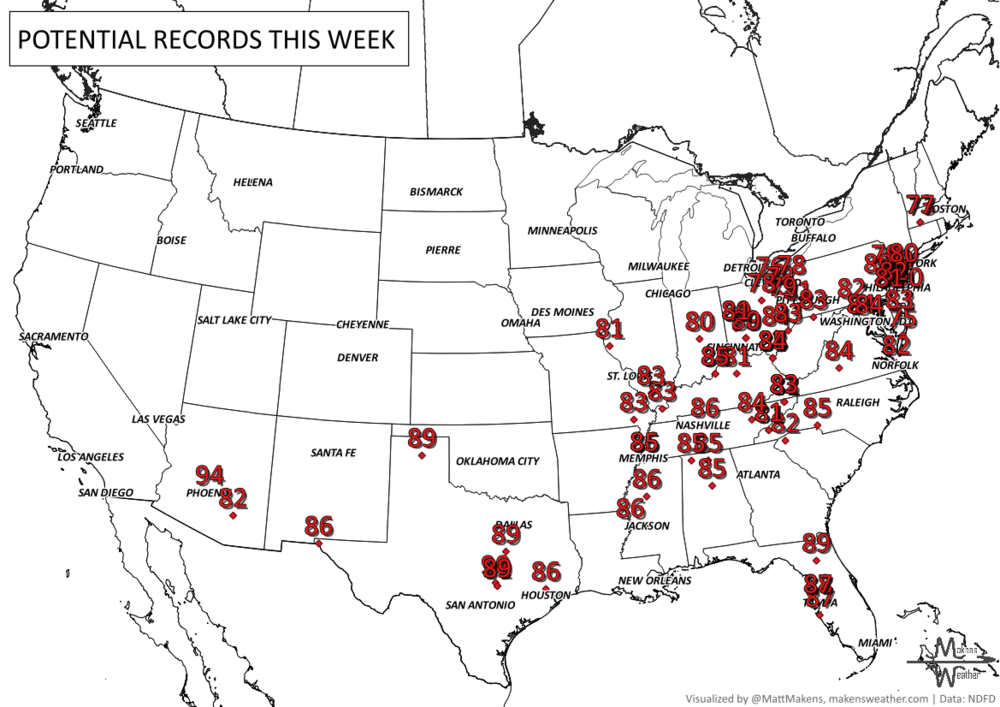
RECORDS MADE TO BE BROKEN, DAILY HIGHS (RED) | DAILY LOWS (BLUE):
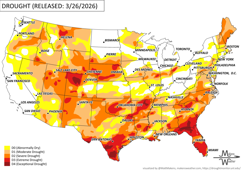
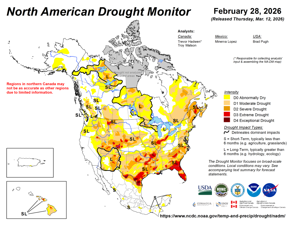
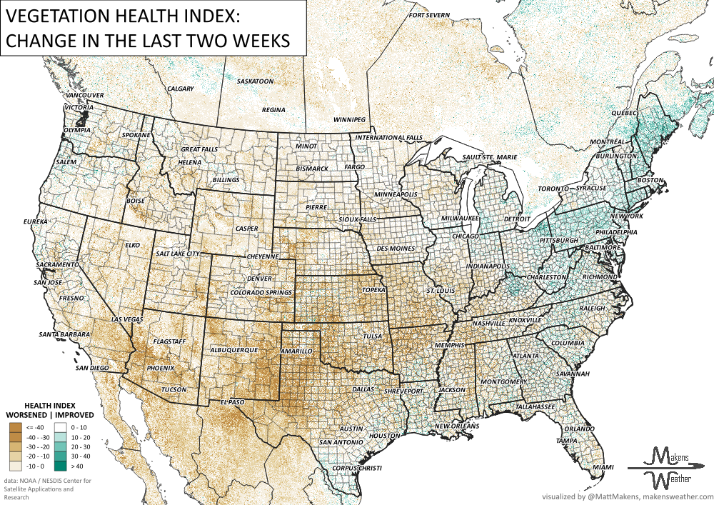
UN-DROUGHTABLY DRY:
ARE YOU CIRRUS?!
Today in weather history:
1962 Seventeen people were killed by a tornado in Milton, FL. It is the worst single tornado in the Sunshine State's history.
1933 A massive F4 tornado cut a devastating 25-mile swath across Jones, Jasper, and Clarke Counties in Mississippi. The tornado left 37 dead and 170 injured that morning.
The weather pattern is about to make a pretty sharp turn across the country. California starts the week with unusual October heat, including highs well into the 90s and even lower 100s in the Central Valley. Meanwhile, much cooler fall air has reached the Great Lakes and Northeast. The Gulf Coast and Southeast stay unsettled, and there’s that record to watch: a tropical depression is likely to develop over the Gulf this week and could strengthen as it moves northeast. If it becomes a hurricane after the 8th, 2026 will have the latest-first hurricane in the Atlantic Basin record.