





Weekly Weather Watch: Tuesday, April 28th, 2026
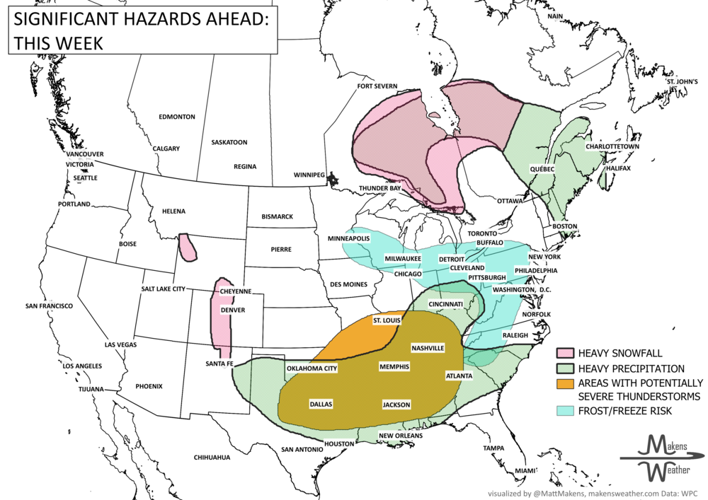
An active stretch of weather is ahead across much of the country. Strong to severe thunderstorms will bring the risk of large hail, damaging wind, a few tornadoes, and heavy rain from Texas into the Lower Mississippi Valley, Mid-South, and Southeast. At the same time, dry and windy conditions will keep fire weather concerns elevated across the Southern High Plains, while cooler air settles into the central and eastern U.S. later this week into the weekend. Periods of heavy rainfall and snowfall for Ontario, Quebec, and the Maritimes.
BRAND NEW PRODUCT☀️📊
Know What's Coming — For Your Exact Location
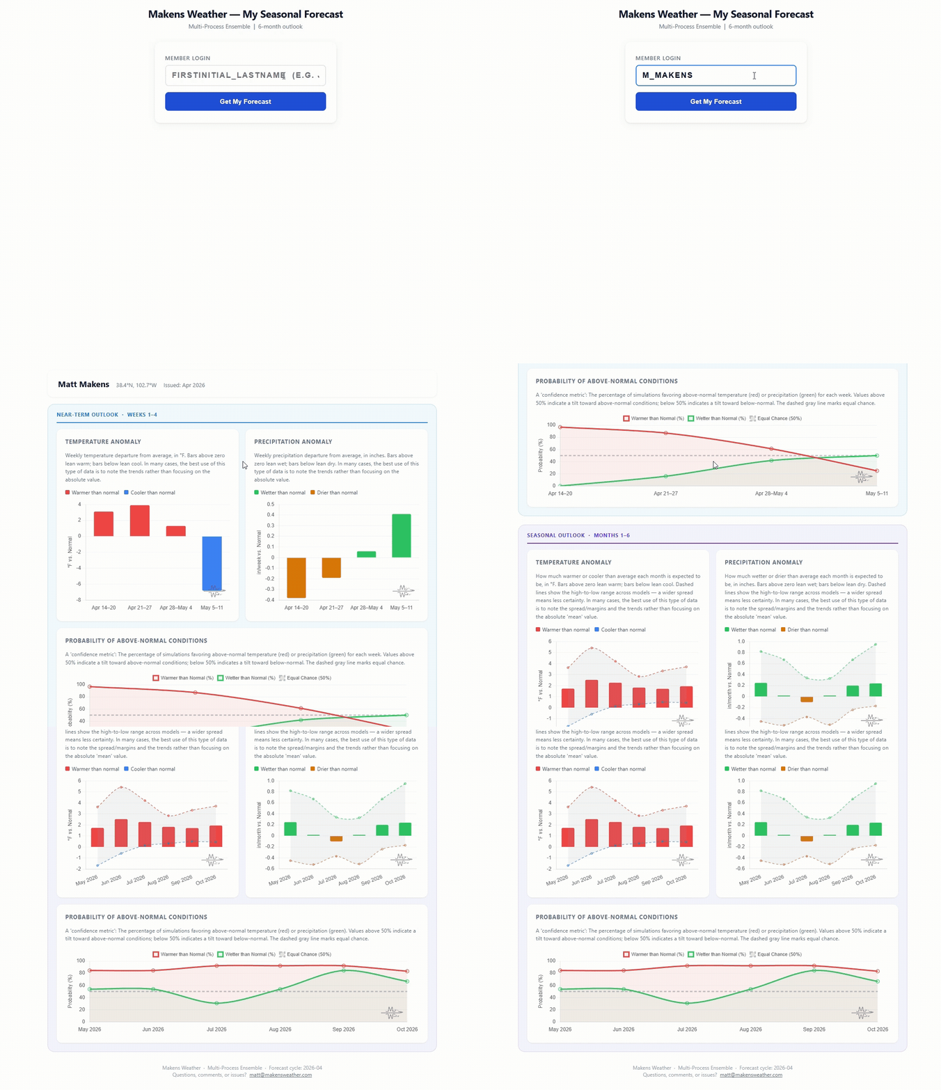
Most seasonal outlooks give you a broad regional brushstroke. The Makens Weather Seasonal Forecast App gives you a point forecast for your location — temperature and precipitation outlooks for the next six months, updated every morning.
Here's what you get as a member:
Your address, not a region: Enter your location once. Every month, the latest consensus forecast is waiting for you.
Weeks 1–4 near-term: Refreshes daily, so short-range planning and seasonal planning live in the same place.
Not just the mean: Charts show the full model spread so you can see how confident the ensemble is, not just which direction it's leaning.
Probability metrics: Know whether 60% or 90% of simulations favor above-normal temperatures. Confidence matters as much as the forecast itself.
If you're making decisions that depend on what the next few months look like — planting windows, input purchases, grazing plans, contract timing — this is the tool that bridges the gap between "what's the general trend" and "what should I actually expect at my operation."
📈 The latest weekly and monthly outlooks 👉 Join Now to Access
HEADLINERS:
Next 7 Days: Key Timing and Impacts
Tuesday: Severe storms possible from Dallas toward Memphis, with large hail, damaging wind, heavy rain, and a tornado risk. Heavy rain and some snow for Ontario.
Tuesday-Wednesday: Critical fire weather continues across eastern New Mexico, the Texas Panhandle, and parts of the Southern High Plains. Wintry mix for Quebec.
Wednesday: Storms shift toward the Gulf Coast, while showers and storms move into the Ohio Valley and Northeast. Wintry mix for Ontario and Quebec.
Thursday: Unsettled weather continues in central Texas, where repeated storms may increase flash flooding concerns. Wintry mix for Ontario and Quebec.
Friday: Heavy rain threat increases from Central Texas into Arkansas, northern Louisiana, western Mississippi, and the Lower Mississippi Valley. Gusty wind for parts of Alberta and Saskatchewan.
Saturday: Heavy rain shifts into the Southeast, including the Florida Panhandle, Georgia, the Carolinas, and nearby areas. Heavy precipitation for Quebec and the Maritimes.
Weekend into early next week: Cool, breezy, showery weather lingers in the Northeast, with frost or freeze concerns possible in parts of the north-central and eastern U.S.
IN THE GAUGES, PRECIPITATION THROUGH THE 5TH:
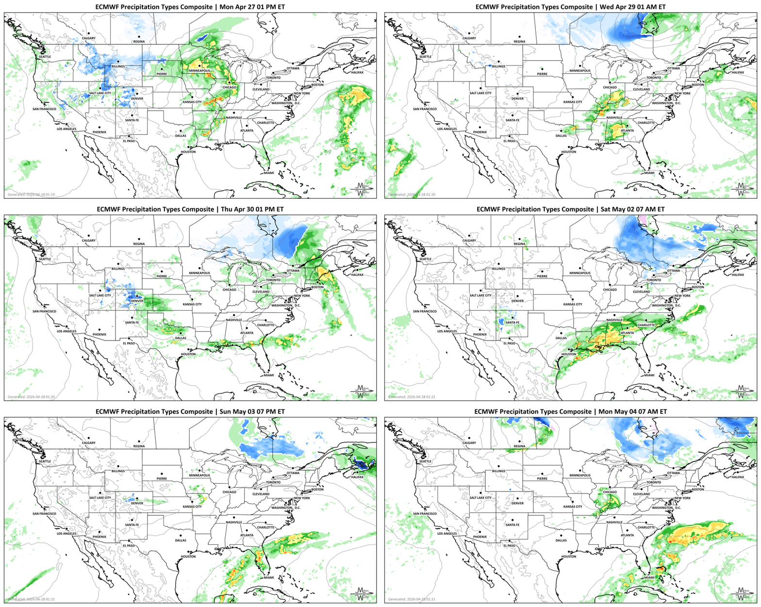
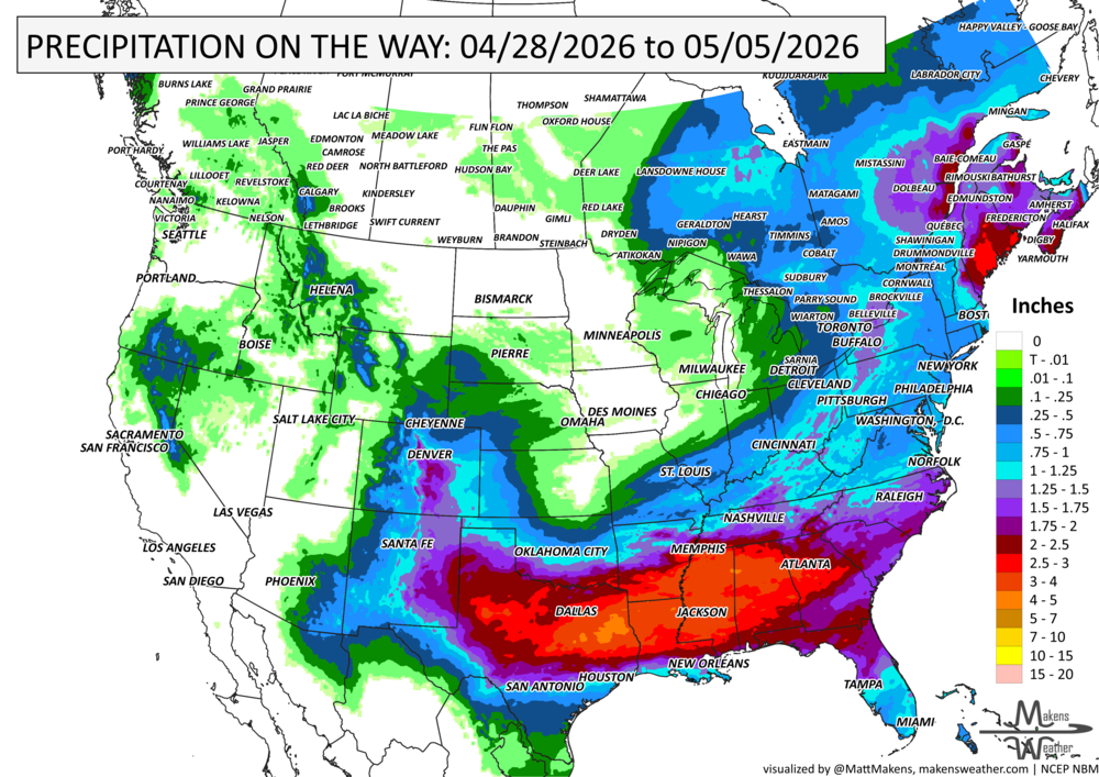
Note: these projected totals are likely to be overdone in many areas because thunderstorms will be the primary source of rainfall, and we know they may be spread apart. So, these types of projections for thunderstorm areas reflect a potential rainfall total if you get the storms to pass over you. The actual observations will be more isolated totals of these magnitudes.
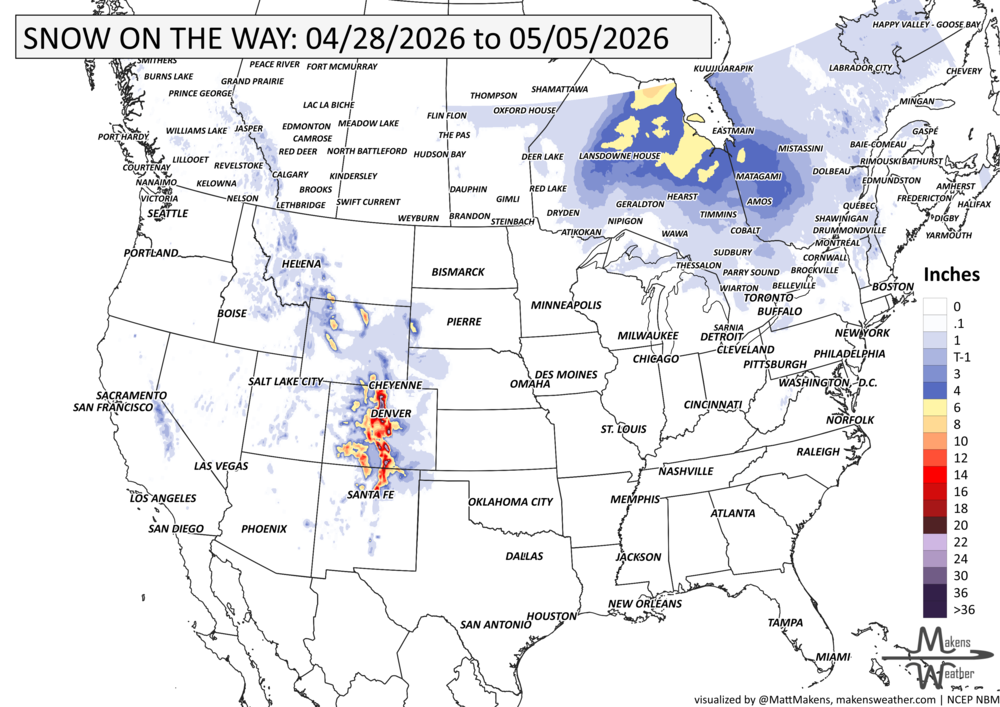
GRAB A RULER, SNOWFALL THROUGH THE 5TH:
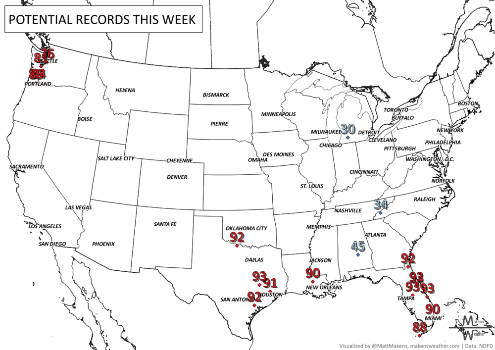
RECORDS MADE TO BE BROKEN, DAILY HIGHS (RED) | DAILY LOWS (BLUE):
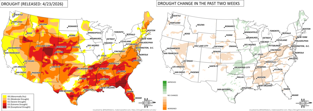
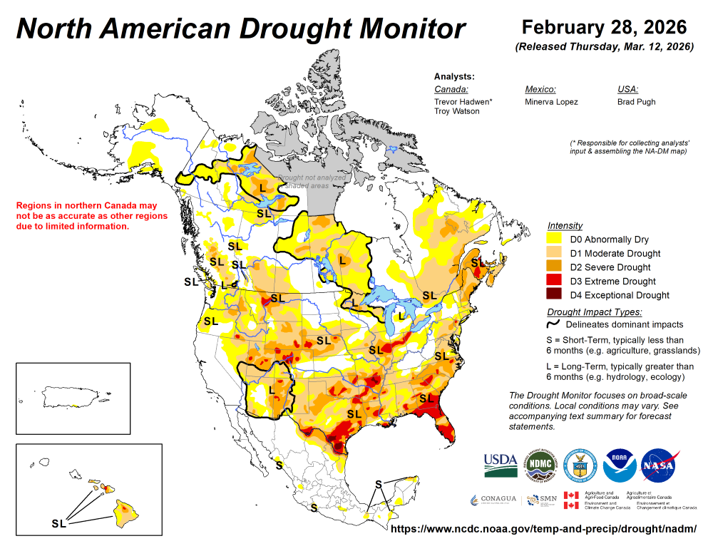
UN-DROUGHTABLY DRY:
A corridor from south Texas through the Midwest into parts of the Great Lakes saw well above normal rainfall, helping improve drought conditions in those areas. In contrast, the Ohio Valley and much of the Southeast remained dry, with little to no rainfall—allowing drought concerns to persist or worsen. Out West, conditions were mostly dry outside of parts of California and the Pacific Northwest, while portions of the Northeast picked up beneficial rain. Temperatures were mixed, with warmer-than-normal conditions across the central and eastern U.S., which can increase evaporation and stress in drier regions. - https://droughtmonitor.unl.edu/
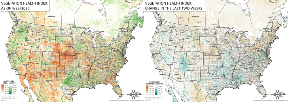
ARE YOU CIRRUS?!
Today in weather history:
1928 A coastal storm produced tremendous late season snows in the central Appalachians, including 35 inches at Bayard, WV, 31 inches at Somerset, PA, and 30 inches at Grantsville, MD. High winds accompanying the heavy wet snow uprooted trees and unroofed a number of homes.
2002 An F4 tornado hit La Plata, MD and traveled a path 6 miles long. The storm killed 3 and injured 90.
The weather pattern is about to make a pretty sharp turn across the country. California starts the week with unusual October heat, including highs well into the 90s and even lower 100s in the Central Valley. Meanwhile, much cooler fall air has reached the Great Lakes and Northeast. The Gulf Coast and Southeast stay unsettled, and there’s that record to watch: a tropical depression is likely to develop over the Gulf this week and could strengthen as it moves northeast. If it becomes a hurricane after the 8th, 2026 will have the latest-first hurricane in the Atlantic Basin record.