





Weekly Weather Watch: Tuesday, April 7th, 2026
A slow-moving frontal boundary will keep Florida unsettled with periods of heavy rain and thunderstorms through midweek, raising localized flooding concerns—especially along the east coast. At the same time, drier air and gusty winds will elevate fire weather risks across parts of the Southeast, particularly from the Florida Panhandle into Georgia. Elsewhere, an active spring pattern continues with storm chances building across the Central Plains, while a strong Kona Low brings widespread impacts to Hawaii through the weekend. Cooler air lingers across the northern U.S. before a gradual warming trend develops late week into the weekend. Heavy snow will blanket areas of Canada from Alberta through central Saskatchewan, southern Manitoba into Ontario and Quebec.
Unlock the Makens Weather Advantage ☀️📊
Your membership includes:
✔️ Real-time dashboard with the latest weather observations and long-range projections
✔️ 6-month-lead forecasts to plan weeks ahead
✔️ Discounts on personalized consultations for ag, energy, or risk planning
All built for decision-makers who need weather insight, not just data.
🎯 Join now and put the forecast to work for you.
📈 The latest outlooks and conditions - track it 👉 Join Now to Access the Dashboard
HEADLINERS:
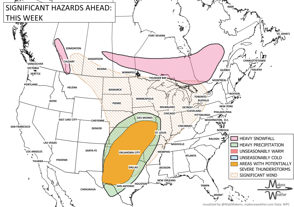
Next 7 Days: Key Timing and Impacts
Tuesday (Apr 7):
Showers and thunderstorms continue across Florida, with heavier rain focused along the east coast of Florida
Fire weather concerns begin across the Florida Panhandle and southeastern Georgia
Wintry mix and gusty winds impact parts of the Great Lakes and Northeast
Scattered showers develop across the Four Corners and Southern Rockies
Snowfall alerts for Alberta to Ontario.
Wednesday (Apr 8):
Lingering heavy rain threat continues across eastern Florida with localized flooding concerns
Elevated to critical fire weather conditions peak across Georgia and nearby areas
Increasing thunderstorm activity across the Central Plains, including Kansas and Nebraska (isolated severe possible)
Cooler conditions persist across the Northern Plains, Midwest, and Northeast
Snowfall alerts for Manitoba to Ontario.
Thursday (Apr 9):
Cold front pushes into the Ohio Valley with scattered showers and storms
Improving conditions begin across Florida
Temperatures begin trending closer to normal or slightly above across much of the U.S.
Heavy snowfall for Ontario to Quebec.
Friday–Saturday:
Continued unsettled weather across Florida and parts of the Southeast U.S.
Increasing rain chances across California and the Southwest as a Pacific system moves inland
Developing heavy rain potential across the Southern Plains
Weekend (Apr 11–12):
Expanding storm system brings rain and possible severe weather to the Southern Plains
Rain spreads into the Midwest
Mountain snow possible across parts of the West
Early Next Week:
Storm system tracks into the Central U.S. and Midwest, with continued rain chances
Warmer temperatures expand north into the Great Lakes and Upper Midwest
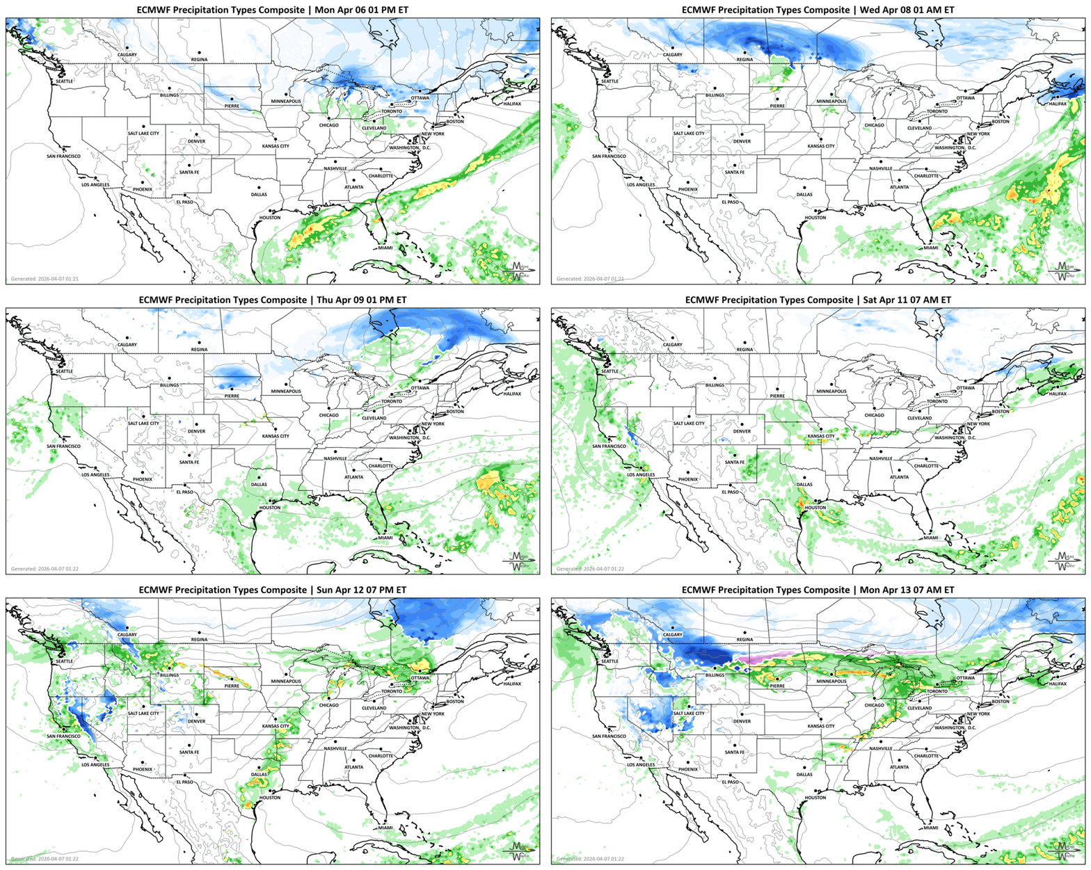
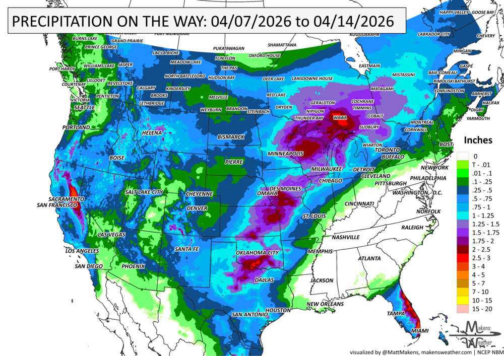
IN THE GAUGES, PRECIPITATION THROUGH THE 14th:
NOTE: FOR THE CENTRAL TO SOUTHERN US, THESE PROJECTED TOTALS ARE LIKELY TO BE OVERDONE FOR MANY AREAS BECAUSE THUNDERSTORMS WILL BE THE SOURCE OF RAINFALL, AND WE KNOW THAT THUNDERSTORMS MAY BE FAR APART, ESPECIALLY OVER OKLAHOMA AND TEXAS. SO, THESE TYPES OF PROJECTIONS FOR THUNDERSTORM AREAS REFLECT A POTENTIAL RAINFALL TOTAL, IF YOU GET THE STORMS TO PASS OVER YOU. THE ACTUAL OBSERVATIONS WILL BE MORE ISOLATED TOTALS TO THESE MAGNITUDES SOUTH OF I-70 OR SO.
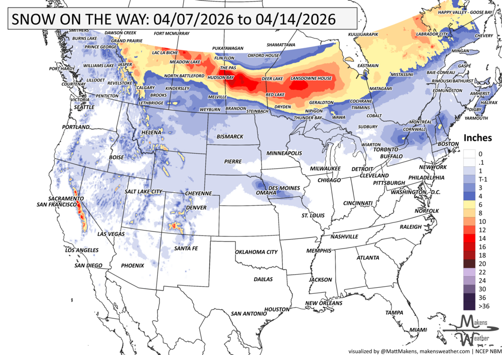
GRAB A RULER, SNOWFALL THROUGH THE 14TH:
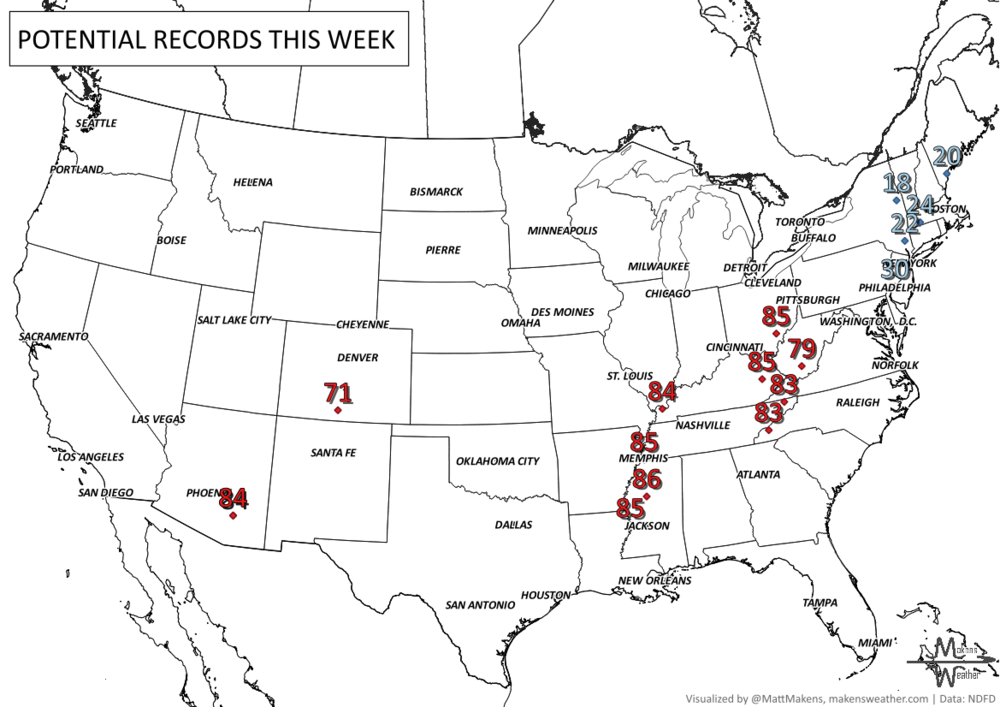
RECORDS MADE TO BE BROKEN, DAILY HIGHS (RED) | DAILY LOWS (BLUE):
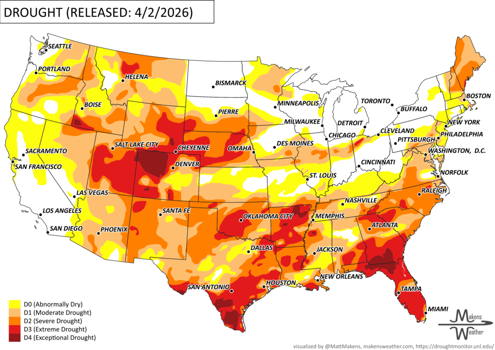
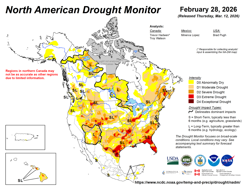
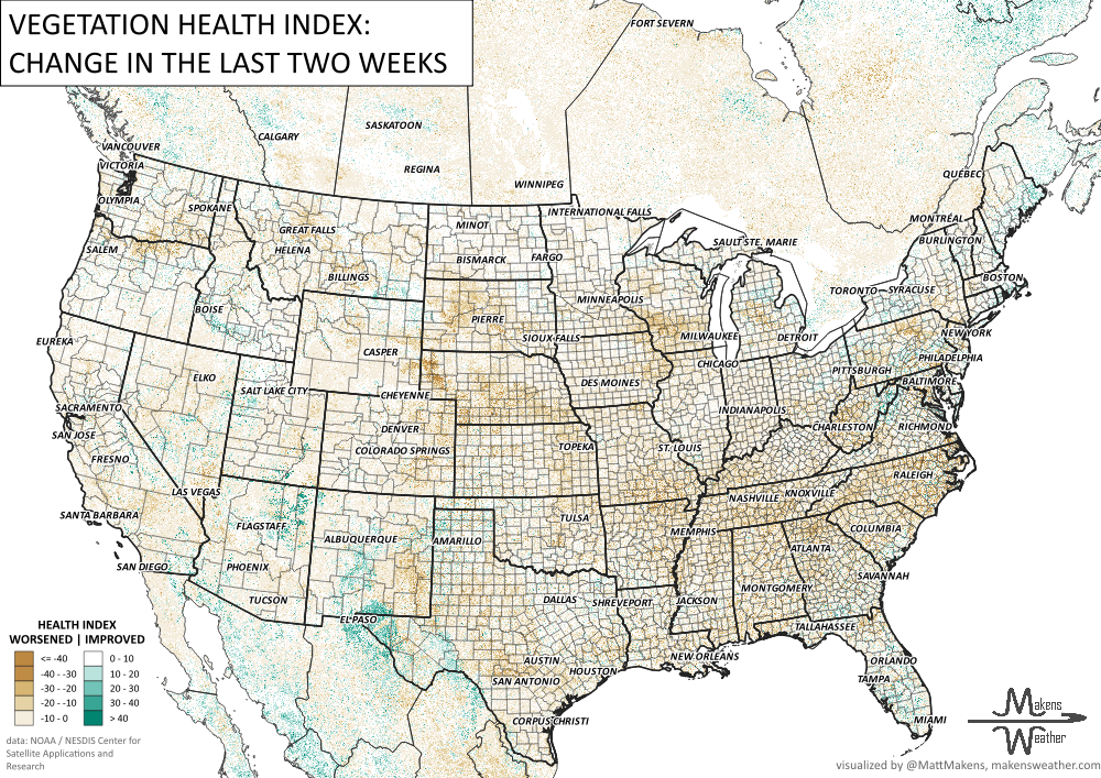
UN-DROUGHTABLY DRY:
ARE YOU CIRRUS?!
Today in weather history:
1990 A dozen cities from Kansas to Indiana and Alabama reported record-low temperatures.
1987: International Falls, MN, with a record warm afternoon high of 71 degrees, was warmer than Miami, where the high was a record-cool 66 degrees.
1857 A late-season freeze brought snow to every state in the Union. Even as far south as Houston, TX the mercury dropped to 21 degrees.
The weather pattern is about to make a pretty sharp turn across the country. California starts the week with unusual October heat, including highs well into the 90s and even lower 100s in the Central Valley. Meanwhile, much cooler fall air has reached the Great Lakes and Northeast. The Gulf Coast and Southeast stay unsettled, and there’s that record to watch: a tropical depression is likely to develop over the Gulf this week and could strengthen as it moves northeast. If it becomes a hurricane after the 8th, 2026 will have the latest-first hurricane in the Atlantic Basin record.