





Weekly Weather Watch: Tuesday, June 30th, 2026
El Niño is officially here, and continued strengthening is expected. We will be watching for its peak strength as a very strong event late in 2026. I posted more on YouTube: El Niño 2026: Regional Outlooks.
A prolonged and dangerous heat wave will dominate the weather story this week as much of the central and eastern United States experiences some of the hottest weather of the year. Heat index values above 100 degrees will become widespread, with some communities seeing readings between 105 and 115 degrees and little relief at night. At the same time, several rounds of severe thunderstorms are expected from the High Plains through the Upper Midwest and Northeast, bringing the threat of damaging winds, large hail, and localized flash flooding. Out West, cooler-than-normal temperatures will continue while dry conditions keep wildfire concerns elevated across parts of the Four Corners and Great Basin. Air quality is an issue across Alberta to Quebec due to wildfire smoke. Heavy precipitation is possible from far eastern Saskatchewan to far western Manitoba.
BRAND NEW PRODUCT☀️📊
Know What's Coming — For Your Exact Location
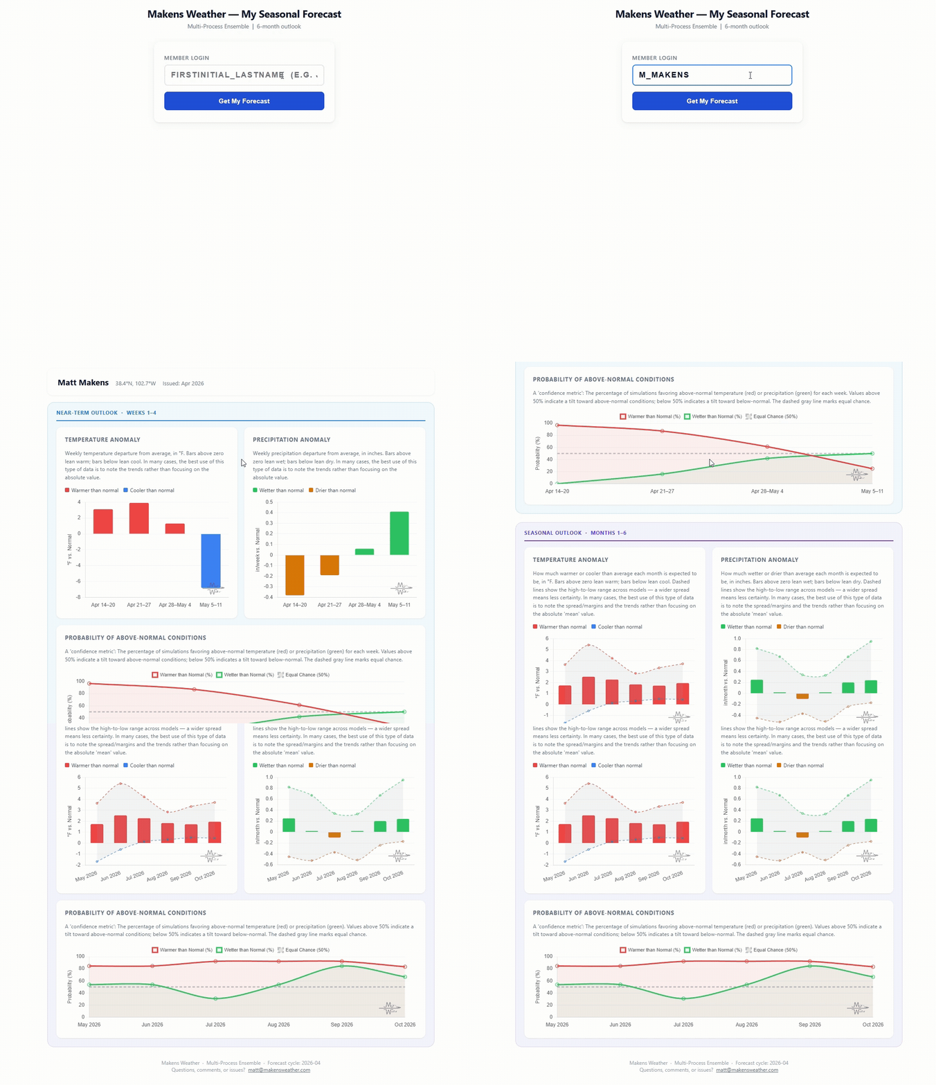
Most seasonal outlooks give you a broad regional brushstroke. The Makens Weather Seasonal Forecast App gives you a point forecast for your location — temperature and precipitation outlooks for the next six months, updated every morning.
Your address, not a region: Enter your location once. Every month, the latest consensus forecast is waiting for you.
Weeks 1–4 near-term: Refreshes daily, so short-range planning and seasonal planning live in the same place.
Not just the mean: Charts show the full model spread so you can see how confident the ensemble is, not just which direction it's leaning.
Probability metrics: Know whether 60% or 90% of simulations favor above-normal temperatures. Confidence matters as much as the forecast itself.
If you're making decisions that depend on what the next few months look like — planting windows, input purchases, grazing plans, contract timing — this is the tool that bridges the gap between "what's the general trend" and "what should I actually expect at my operation."
📈 The latest weekly and monthly outlooks 👉 Join Now to Access
HEADLINERS:
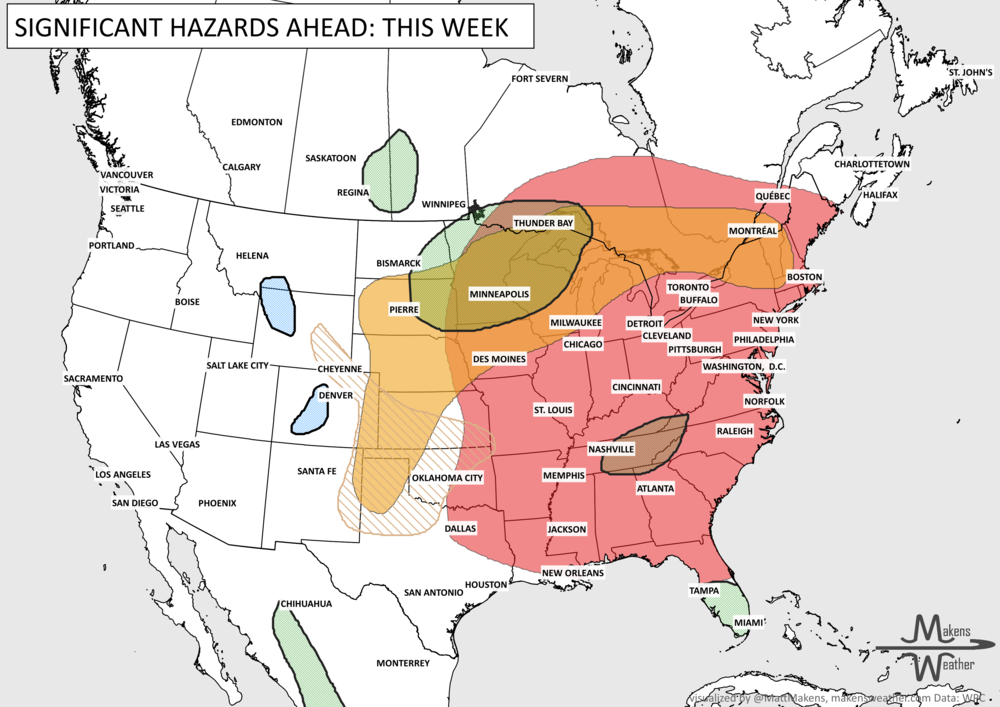
Next 7 Days: Key Timing and Impacts
Tuesday: Dangerous heat expands across the Midwest, Mississippi Valley, and Southern Plains with heat indices topping 100 degrees. Air quality issues for much of central Canada. Heavy rainfall for eastern Saskatchewan and western Manitoba.
Tuesday-Wednesday: Severe thunderstorms develop from the Central High Plains into the Upper Midwest, producing damaging winds, large hail, and heavy rainfall. The risk extends into Manitoba and Ontario.
Wednesday: Strong to severe storms spread into the Great Lakes and portions of the Northeast.
Tuesday-Thursday: Localized flash flooding remains possible across the Southeast, Eastern New Mexico, and West Texas.
Through Thursday: Critical fire weather continues across the Four Corners and Great Basin.
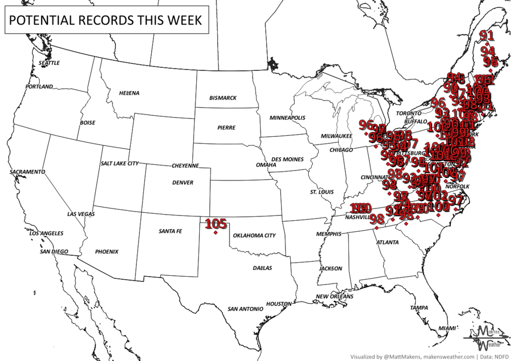
Thursday-Friday: Heat reaches maximum intensity across the Midwest, Ohio Valley, Mid-Atlantic, and East Coast, with widespread heat indices between 105 and 115 degrees and numerous daily record highs.
Friday-Saturday: Scattered thunderstorms continue from the Northern Plains through the Great Lakes, with localized flooding possible.
Weekend: The heat slowly eases from west to east across portions of the Midwest and Great Lakes, while showers and thunderstorms expand into the Ohio Valley, Tennessee Valley, and much of the East.
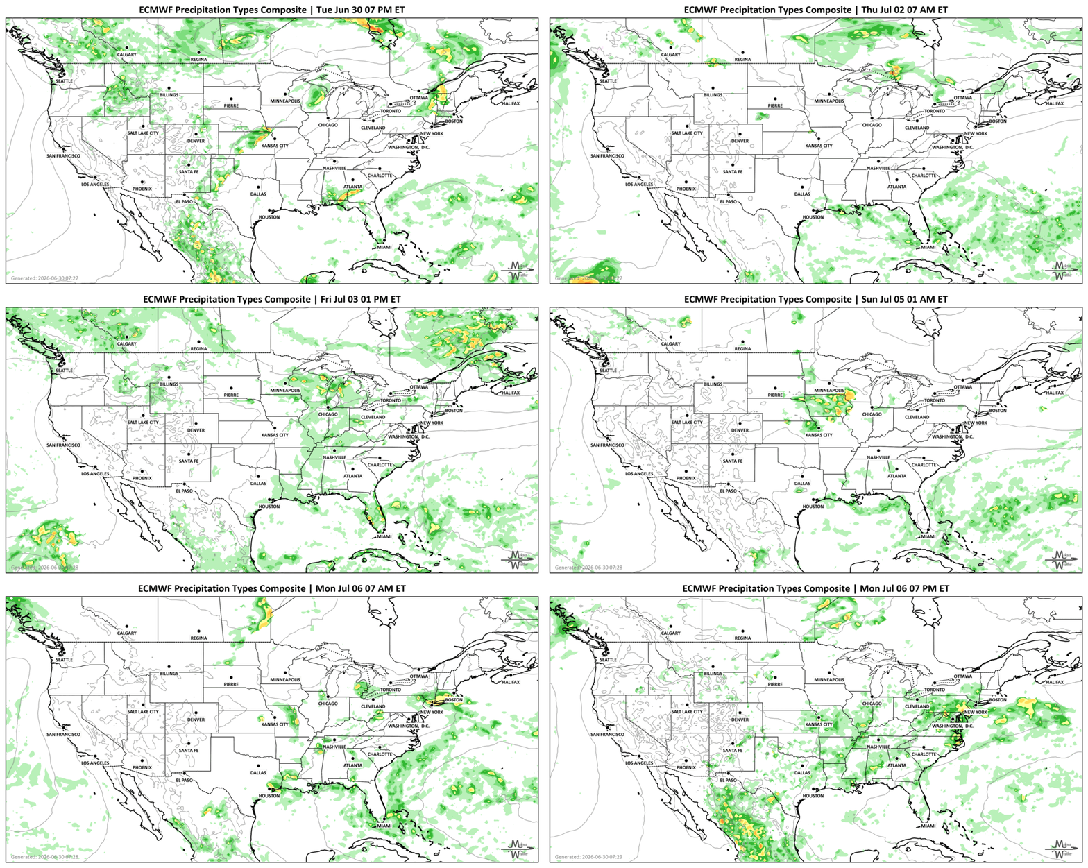
SET YOUR WATCHES - WHEN THE MOISTURE ARRIVES:
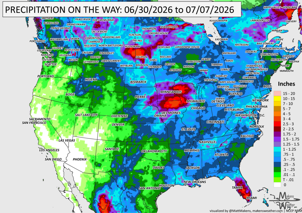
IN THE GAUGES, PRECIPITATION THROUGH THE 7TH:
Note: these projected totals are likely to be over/under-done in many areas because thunderstorms will be the primary source of rainfall, and we know what they can do.
RECORDS MADE TO BE BROKEN, DAILY HIGHS (RED) | DAILY LOWS (BLUE):
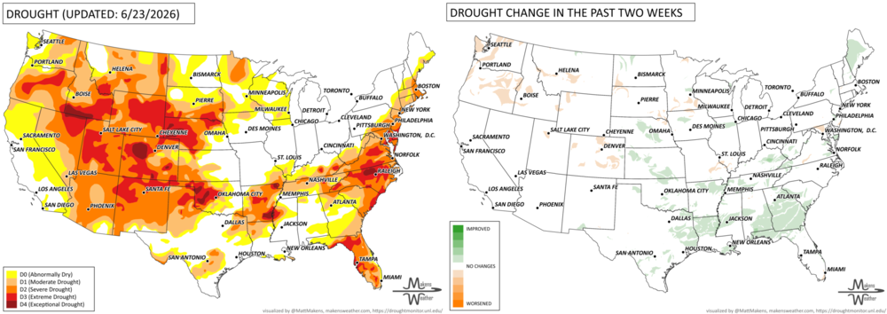
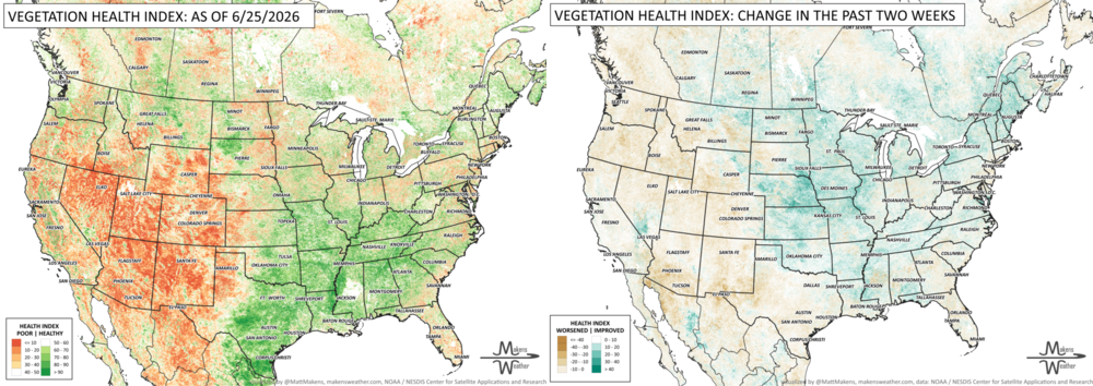
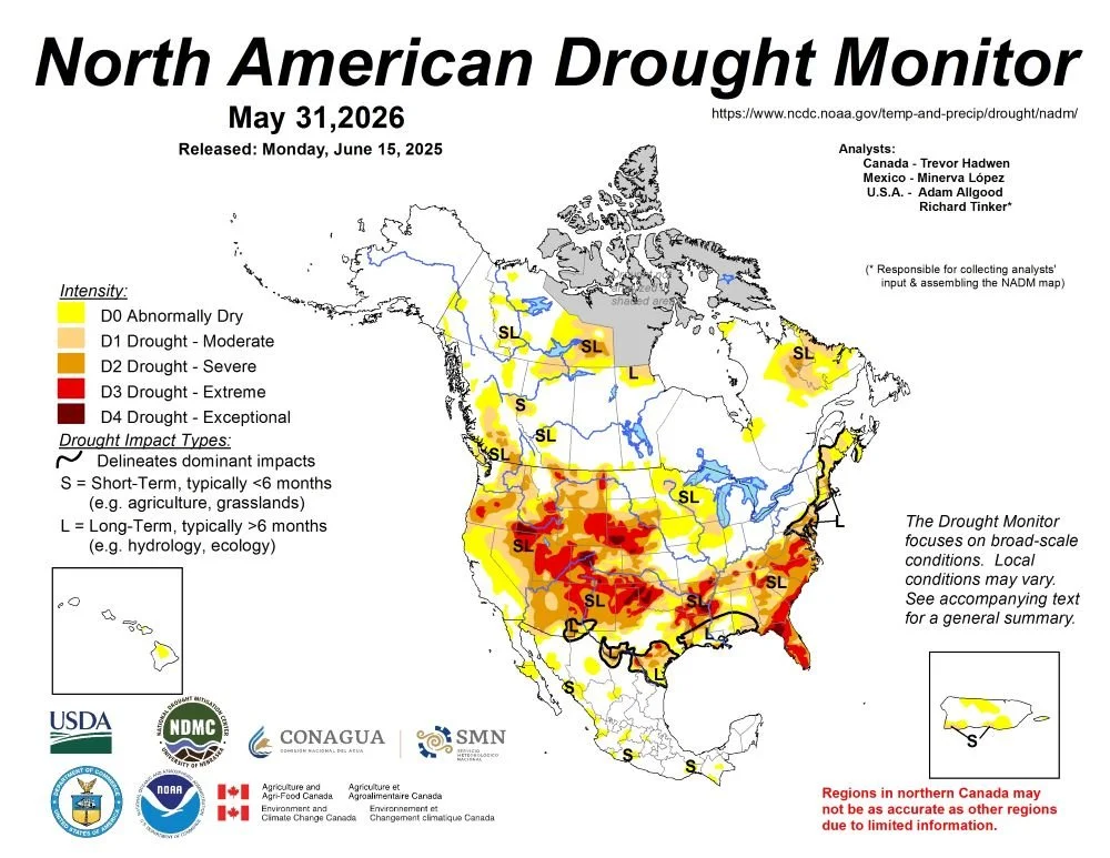
UN-DROUGHTABLY DRY:
Tropical Storm Arthur briefly formed near the middle Texas coast on June 17, hours before wobbling inland near Galveston. However, a precursor low-pressure system delivered heavy rain in parts of southern Texas, followed by a post-tropical deluge from the central Gulf Coast region into the lower Southeast. Totals of 4 to 8 inches or more were common across the Deep South, with higher amounts observed in several spots. Although flash flooding and lowland flooding occurred, overall impacts were muted by antecedent drought, which until recently had spanned the South. Farther north, a series of cold fronts sparked occasional showers and thunderstorms, resulting in localized wind and hail damage but maintaining favorable soil moisture reserves for most Midwestern summer crops. The Plains also received scattered showers, amid variable impacts related to lingering drought on rangeland, pastures, and summer crops. Meanwhile, the Plains’ winter wheat harvest quickly advanced between showers, as the drought-affected crop dried down ahead of the normal pace. In the western U.S., hot, mostly dry weather prevailed. Complications related to Western heat included heavy irrigation demands and a broadly elevated wildfire threat. One of the region’s most significant wildfires, the Iron Fire near Eureka, Utah, ignited on June 19 and quickly burned more than 37,000 acres of grass and chaparral. - https://droughtmonitor.unl.edu/
TRACKING THE TROPICS
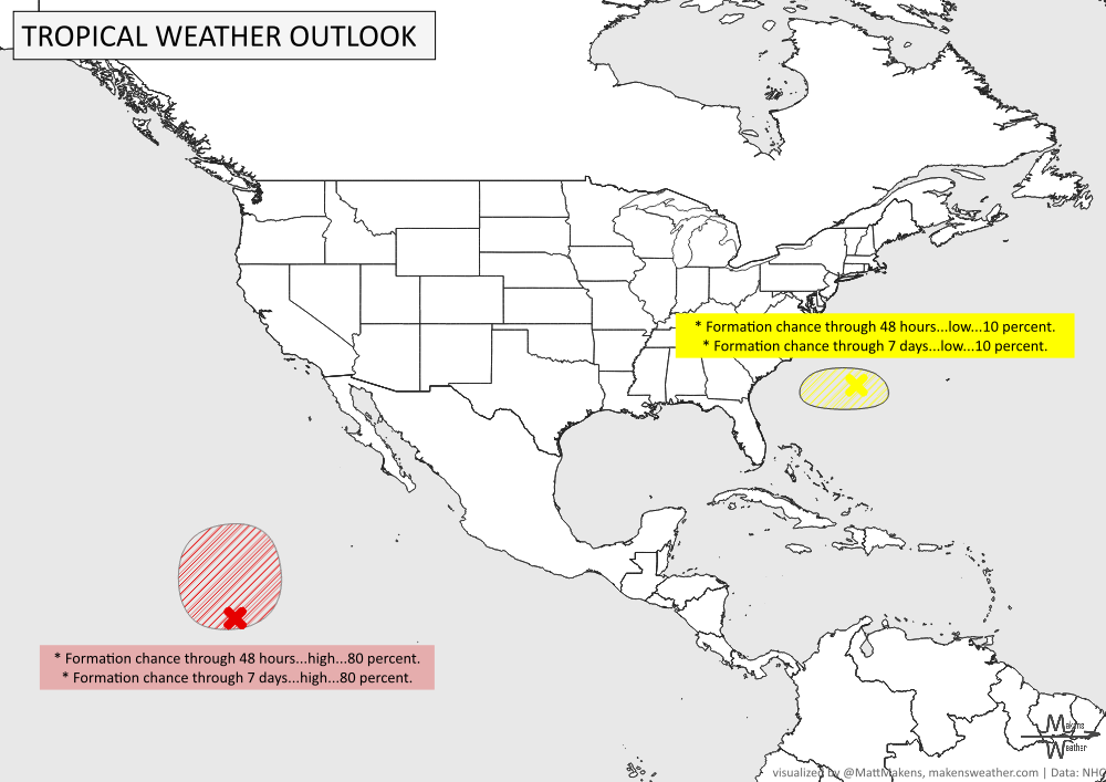
Offshore of the Southeastern U.S. Coast: A weak area of low pressure located along a frontal boundary off the southeastern U.S. coast is associated with limited shower and thunderstorm activity. Environmental conditions are becoming less conducive for significant development of this system as it drifts southward and then westward later this week.
* Formation chance through 48 hours...low...10 percent.
* Formation chance through 7 days...low...10 percent.
Western East Pacific: A broad area of low pressure located well southwest of the southern tip of the Baja California Peninsula is producing showers and thunderstorms that are showing signs of organization. Gradual development of this system is expected during the next couple of days, and a tropical depression is likely to form tonight or on Wednesday while the system moves generally northwestward and then northward.
* Formation chance through 48 hours...high...80 percent.
* Formation chance through 7 days...high...80 percent.
ARE YOU CIRRUS?!
Today in weather history:
1792: The first recorded tornado in Canadian history struck the Niagara Peninsula between Foothill and Port Robinson, leveling some houses and uprooting trees between the communities.
1900: The combination of high winds and the presence of wooded fuel-filled cargo helped to spread fire on the Hoboken Docks in New Jersey. The fire began when cotton bales caught fire and spread to nearby volatile liquids. The fire killed at least 300 people and was seen in New York City.
1912: An estimated F4 tornado ripped through Regina, Saskatchewan, Canada on this day. The storm became the deadliest tornado in Canada's history as it killed 28 people along a rare, 18.5-mile track from south to north.
1999: Mount Baker, Washington closed out a record snowfall season both for the United States and the verifiable world record as the seasonal total from July 1, 1998, to June 30, 1999, finished with 1,140 inches.
The weather pattern is about to make a pretty sharp turn across the country. California starts the week with unusual October heat, including highs well into the 90s and even lower 100s in the Central Valley. Meanwhile, much cooler fall air has reached the Great Lakes and Northeast. The Gulf Coast and Southeast stay unsettled, and there’s that record to watch: a tropical depression is likely to develop over the Gulf this week and could strengthen as it moves northeast. If it becomes a hurricane after the 8th, 2026 will have the latest-first hurricane in the Atlantic Basin record.