





Weekly Weather Watch: Tuesday, July 21st, 2026
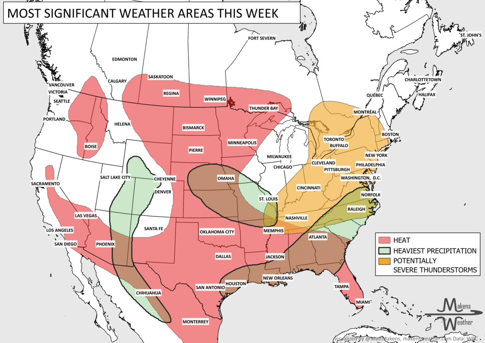
Tropical Storm Bertha is one of several weather systems requiring attention this week. Bertha could bring tropical-storm conditions, storm surge and periods of heavy rain to portions of the Florida Panhandle and Alabama coast through Wednesday before tracking westward along the central and western Gulf Coast. Elsewhere, severe thunderstorms and flash flooding may affect a broad area from the Mid-South and Ohio Valley into the Mid-Atlantic and Northeast. Monsoon thunderstorms will continue across the Southwest and Rockies, while dangerous heat gradually expands from the Southern Plains and Southeast into the central Plains, Canadian Prairies, and Interior West.
El Niño is well on its way to being one of the strongest in the modern record. Is it the next 1997? I posted more on YouTube: Why 2026 El Niño Isn't a Simple Repeat of 1997
UPDATED SEASONAL OUTLOOKS☀️📊
Know What's Coming — For Your Exact Location
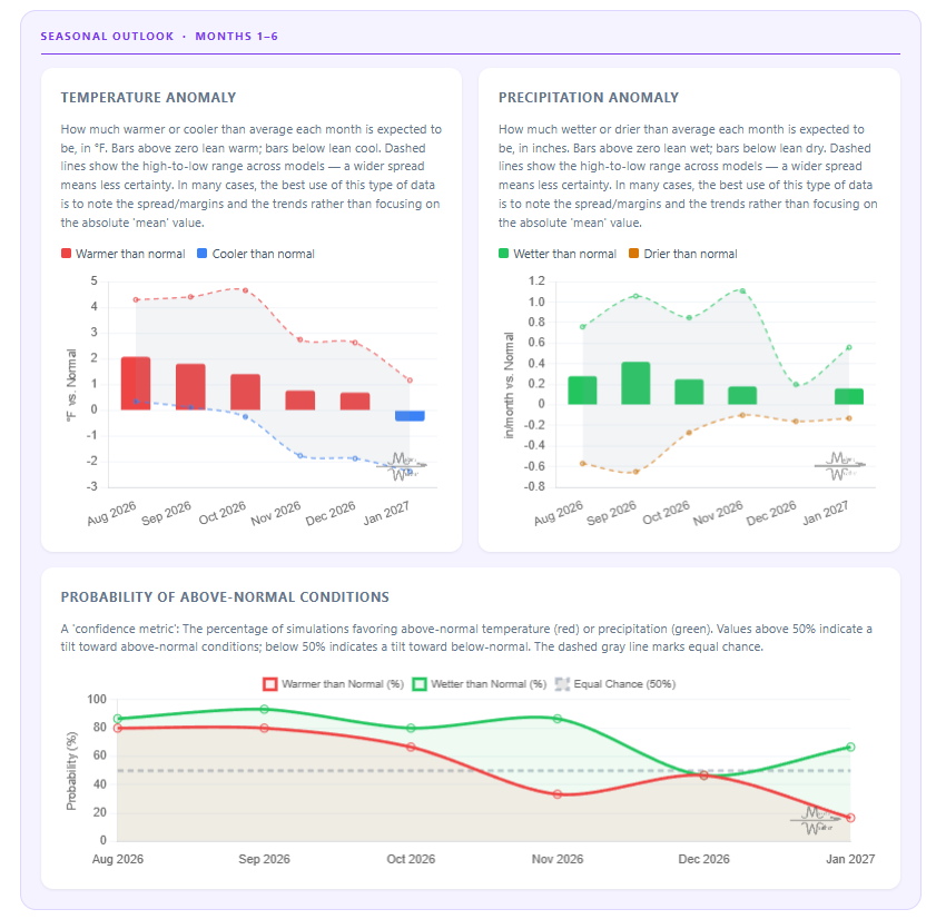
Most seasonal outlooks give you a broad regional brushstroke. The Makens Weather Seasonal Forecast App gives you a point forecast for your location — temperature and precipitation outlooks for the next six months, updated every morning.
Your address, not a region: Enter your location once. Every month, the latest consensus forecast is waiting for you.
Weeks 1–4 near-term: Refreshes daily, so short-range planning and seasonal planning live in the same place.
Not just the mean: Charts show the full model spread so you can see how confident the ensemble is, not just which direction it's leaning.
Probability metrics: Know whether 60% or 90% of simulations favor above-normal temperatures. Confidence matters as much as the forecast itself.
If you're making decisions that depend on what the next few months look like — planting windows, input purchases, grazing plans, contract timing — this is the tool that bridges the gap between "what's the general trend" and "what should I actually expect at my operation."
📈 The latest weekly and monthly outlooks 👉 Join Now to Access
HEADLINERS:
Next 7 Days: Key Timing and Impacts
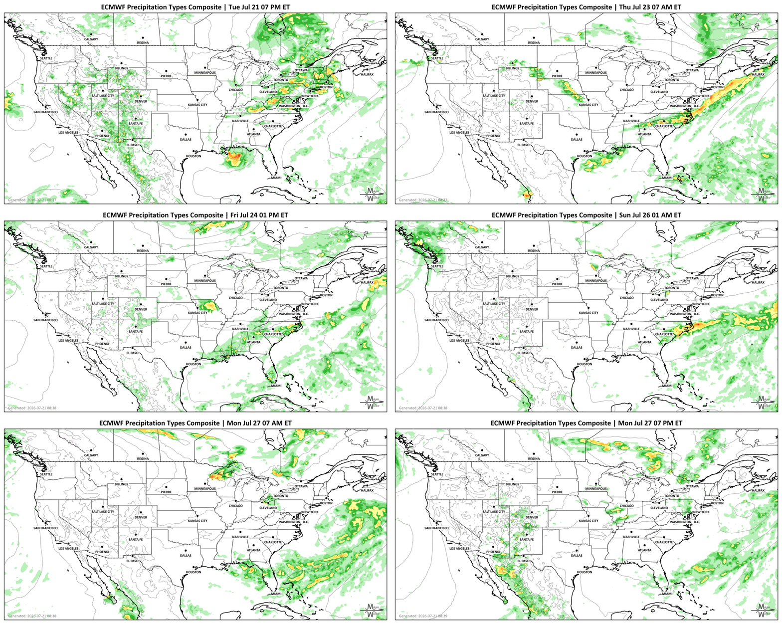
Tuesday, July 21: Severe thunderstorms and heavy rain develop from the Mid-South and Ohio Valley into the Mid-Atlantic, Northeast, and Eastern Canada. Damaging winds and flash flooding are the main threats. Tropical rain bands approach the Florida Panhandle and Alabama coast.
Wednesday, July 22: Tropical-storm conditions, coastal flooding and locally heavy rain remain possible along the northeastern Gulf Coast. Severe storms and flooding shift toward the lower Mid-Atlantic. Monsoon storms continue across the Southwest and Rockies.
Thursday, July 23: Bertha moves westward near the central Gulf Coast, spreading tropical moisture toward Louisiana. Heavy thunderstorms may continue near the Carolinas and Southeast coast. Heat builds across the Northwestern US and Southwestern Canada.
Friday, July 24: Locally heavy rain becomes more likely along the central Gulf Coast, eastern Carolinas and portions of the mid-Mississippi Valley. Repeated storms could produce localized flooding. Heat continues to build across the West.
Saturday, July 25: Bertha’s moisture shifts farther west toward the western Gulf Coast and Texas. Flooding remains possible near the coast. Heat begins expanding northward across the Plains.
Sunday, July 26: Dangerous heat spreads across the Canadian Prairies, Central Plains, Southwest and Interior West. Monsoon thunderstorm coverage begins to decrease, although localized flooding remains possible.
Monday into Tuesday, July 27–28: Broad heat continues across the Prairies, Plains, Rockies, Southwest and Intermountain West. Rain chances persist in the Pacific Northwest, while tropical moisture may linger near Texas and the western Gulf Coast.
SET YOUR WATCHES - WHEN THE MOISTURE ARRIVES:
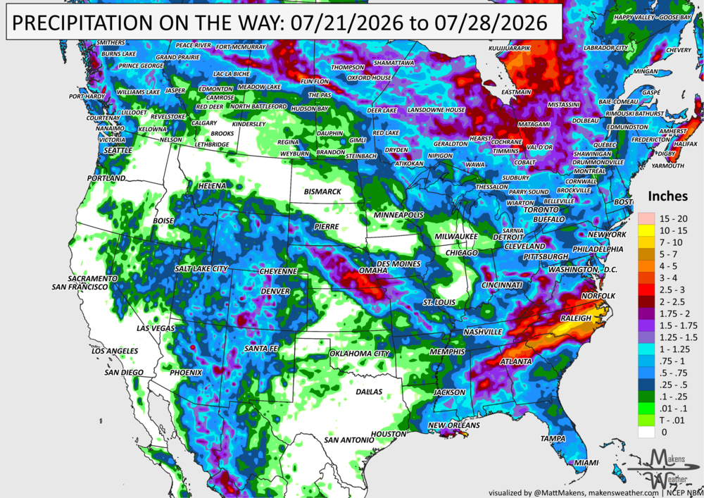
IN THE GAUGES, PRECIPITATION THROUGH THE 28th:
Note: these projected totals are likely to be over/under-done in many areas because thunderstorms will be the primary source of rainfall, and we know what they can do.
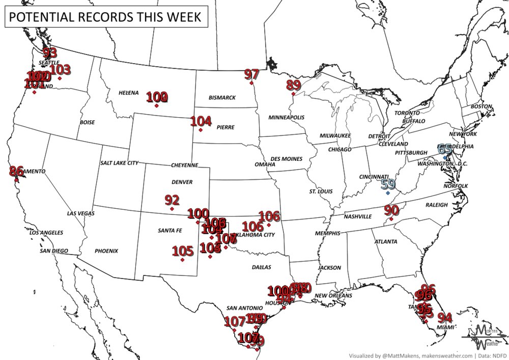
RECORDS MADE TO BE BROKEN, DAILY HIGHS (RED) | DAILY LOWS (BLUE):
Heat will persist across the Southern Plains and Southeast, where the combination of high temperatures and humidity may make it feel between 105 and 115 degrees in some communities. Warm nights will provide limited recovery, especially for people without reliable air conditioning. The heat is expected to expand into the central and northern Plains, Southwest, Intermountain West and Rockies this weekend and early next week.
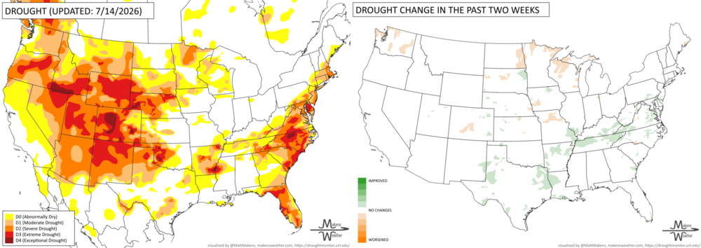
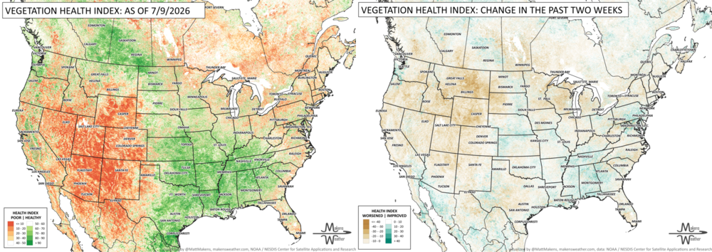
UN-DROUGHTABLY DRY:
Heavy rainfall this week brought meaningful drought relief from northeast Texas through the Mid-Atlantic, with additional localized improvements in southern New York, southern New England, parts of the central Great Plains, northwest Alaska, Puerto Rico, Utah, western Oklahoma, and portions of Texas. However, drought worsened across parts of the western Great Lakes, Washington, central Colorado, southeast Florida, and south-central Puerto Rico, where continued dry weather, low streamflows, and rainfall deficits led to expanding drought conditions.
FIRE!
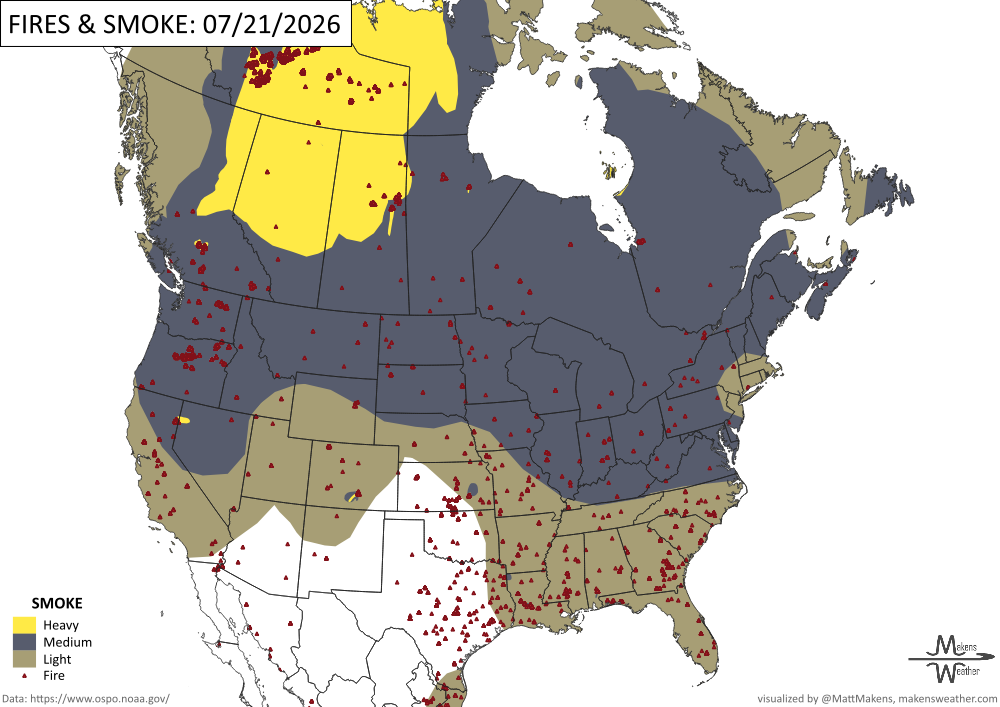
As of July 20, firefighters are battling 74 large wildfires nationwide, including five new incidents. Nearly 19,400 personnel are assigned, supported by hundreds of crews, more than 1,100 engines, 140 helicopters, and four military MAFFS airtankers. More than 40,000 fires have burned over 3.9 million acres so far this year. The greatest strain on resources is in the Northwest and northern Minnesota, so crews and equipment are being moved nationally based on threats to lives, property, and operational needs. The shifting of resources reflects a coordinated national response designed to get help quickly to the areas facing the greatest danger.
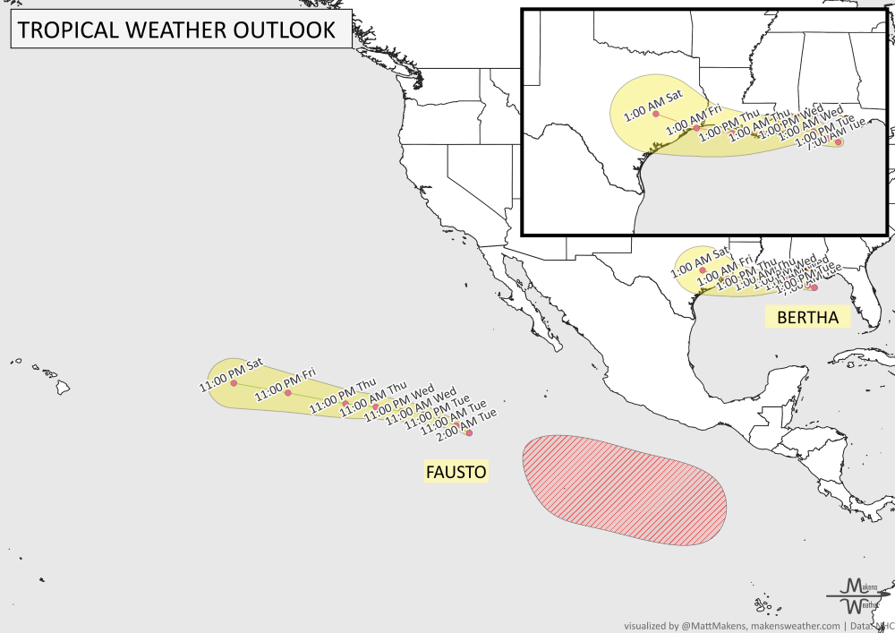
TRACKING THE TROPICS
Tropical Storm Bertha could produce tropical-storm conditions, elevated water levels and heavy rainfall near portions of the Florida Panhandle and Alabama coast through Wednesday. The storm is expected to continue westward near the Louisiana coast and eventually toward Texas later in the week. The heaviest rain may remain offshore at times, but outer rain bands could still produce localized flooding near the coast. Residents and visitors along the Gulf Coast should continue checking official NWS forecasts because relatively small changes in Bertha’s track could shift where the heaviest rainfall and coastal impacts occur.
ARE YOU CIRRUS?!
In weather history:
1983: At Vostok Station in Antarctica, the temperature dropped to 128.6 degrees below zero. This reading is the coldest temperature ever recorded.
1987: An F4 tornado ravages the Teton Wilderness and Yellowstone National Park in Wyoming. The tornado's violent winds destroy millions of trees on a 24.3-mile track that traverses the Continental Divide at an elevation of 10,170 feet.
The weather pattern is about to make a pretty sharp turn across the country. California starts the week with unusual October heat, including highs well into the 90s and even lower 100s in the Central Valley. Meanwhile, much cooler fall air has reached the Great Lakes and Northeast. The Gulf Coast and Southeast stay unsettled, and there’s that record to watch: a tropical depression is likely to develop over the Gulf this week and could strengthen as it moves northeast. If it becomes a hurricane after the 8th, 2026 will have the latest-first hurricane in the Atlantic Basin record.