





Weekly Weather Watch: Tuesday, July 28th, 2026
The weather pattern across the United States and Canada remains highly active this week, with two major stories dominating the forecast. Dangerous, long-lasting heat continues across much of the South before expanding into the western United States by the weekend. At the same time, repeated rounds of thunderstorms will bring the threat of flash flooding and severe weather from the Mid-Atlantic and Northeast to parts of the Midwest and Gulf Coast and parts of western to central Canada. Residents across these regions should stay weather-aware as heavy rain, damaging winds, and dangerous heat create multiple hazards over the coming week.
El Niño is well on its way to being one of the strongest in the modern record. Is it the next 1997? I posted more on YouTube: Why 2026 El Niño Isn't a Simple Repeat of 1997
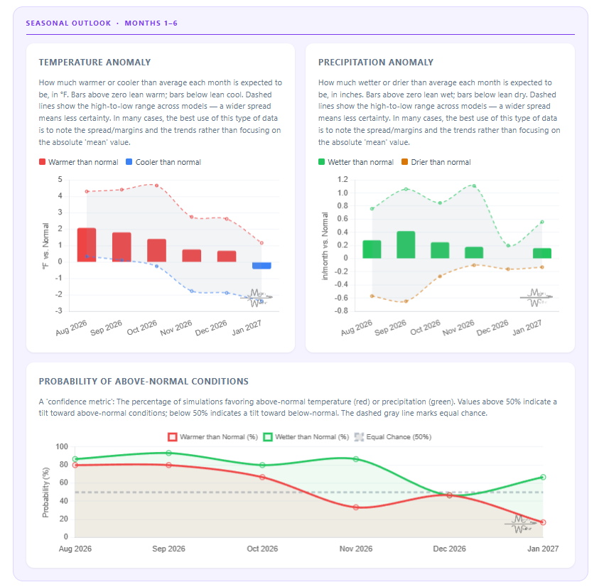
UPDATED SEASONAL OUTLOOKS☀️📊
Know What's Coming — For Your Exact Location
Most seasonal outlooks give you a broad regional brushstroke. The Makens Weather Seasonal Forecast App gives you a point forecast for your location — temperature and precipitation outlooks for the next six months, updated every morning.
Your address, not a region: Enter your location once. Every month, the latest consensus forecast is waiting for you.
Weeks 1–4 near-term: Refreshes daily, so short-range planning and seasonal planning live in the same place.
Not just the mean: Charts show the full model spread so you can see how confident the ensemble is, not just which direction it's leaning.
Probability metrics: Know whether 60% or 90% of simulations favor above-normal temperatures. Confidence matters as much as the forecast itself.
If you're making decisions that depend on what the next few months look like — planting windows, input purchases, grazing plans, contract timing — this is the tool that bridges the gap between "what's the general trend" and "what should I actually expect at my operation."
📈 The latest weekly and monthly outlooks 👉 Join Now to Access
HEADLINERS:
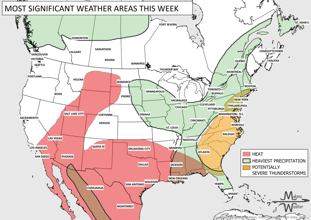
Next 7 Days: Key Timing and Impacts
Tuesday
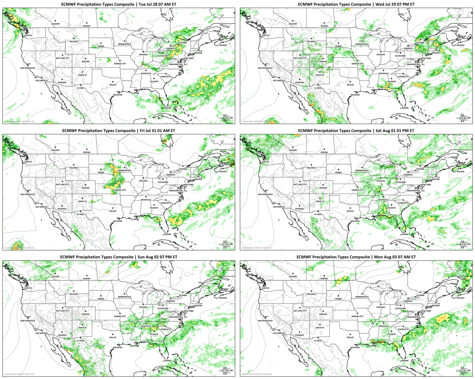
🌧️ Mid-Atlantic and Southern New England face the greatest risk for flash flooding as repeated thunderstorms develop.
⛈️ Severe thunderstorms capable of damaging winds, large hail, and isolated tornadoes threaten the Carolinas into the Mid-Atlantic.
🔥 Dangerous heat continues across Texas, Oklahoma, the Lower Mississippi Valley, and the Gulf Coast, with heat index values reaching 105–115°.
⛈️ Monsoon thunderstorms continue across the Four Corners, bringing localized flash flooding, especially near burn scars and slot canyons.
🔥 Air quality and heat for parts of BC, AB, and SK.
Wednesday
🌧️ Heavy rain shifts farther into the Northeast, with additional flash flooding possible.
⛈️ Thunderstorms develop across the Central High Plains, producing large hail and damaging winds.
🌦️ Slow-moving storms increase flooding concerns across portions of the Southeast and Central Gulf Coast.
🔥 Extreme heat continues across the southern tier.
Thursday
🌩️ Thunderstorms continue across portions of the Mississippi Valley and Southeast with localized flooding concerns.
🌧️ Monsoon moisture remains active across the Rockies and Southwest.
Friday
🌡️ A significant Western heat wave begins strengthening across the Desert Southwest, California, Nevada, Utah, and the Great Basin.
⛈️ Multiple rounds of thunderstorms develop from Minnesota southward toward Missouri, bringing heavy rainfall and flooding potential. Potential exists for additional heavy rainfall from British Columbia, across the Peace Region toward the central to northern portions of Saskatchewan and Manitoba.
Saturday
🔥 Dangerous and long-duration heat spreads across much of the Western U.S., extending into the Northern Rockies and High Plains.
🌡️ Temperatures soar well above normal across the Desert Southwest, with some desert locations approaching 120°.
🌧️ Heavy rain continues across portions of the Deep South and Gulf Coast, across the Peace Region toward the central to northern portions of Saskatchewan and Manitoba.
Sunday
🌩️ Thunderstorms become more widespread across the Eastern U.S. as another disturbance develops.
🌦️ Monsoon storms continue over parts of the Central Rockies and Southwest, although coverage begins to decrease.
🌧️ Areas of heavy rainfall are centered on the Peace Region and expanding toward the Prairies.
Monday
🔥 Heat remains widespread across the West, Central Plains, and portions of California.
🌦️ A cold front gradually cools the Northern Plains, while much of the East Coast begins warming again.
SET YOUR WATCHES - WHEN THE MOISTURE ARRIVES:
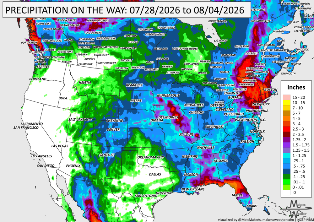
IN THE GAUGES, PRECIPITATION THROUGH THE 4th:
Note: these projected totals are likely to be over/under-done in many areas because thunderstorms will be the primary source of rainfall, and we know what they can do.
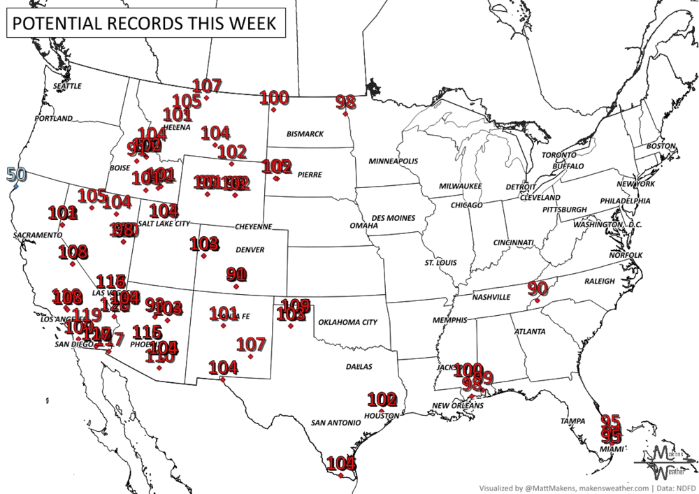
RECORDS MADE TO BE BROKEN, DAILY HIGHS (RED) | DAILY LOWS (BLUE):
The hottest weather remains across the Southern Plains, Lower Mississippi Valley, and Gulf Coast through the week before shifting westward into a major heat wave covering much of the Western U.S. through early August. Overnight temperatures will remain unusually warm, providing little relief and increasing the risk of heat-related illness.
UN-DROUGHTABLY DRY:
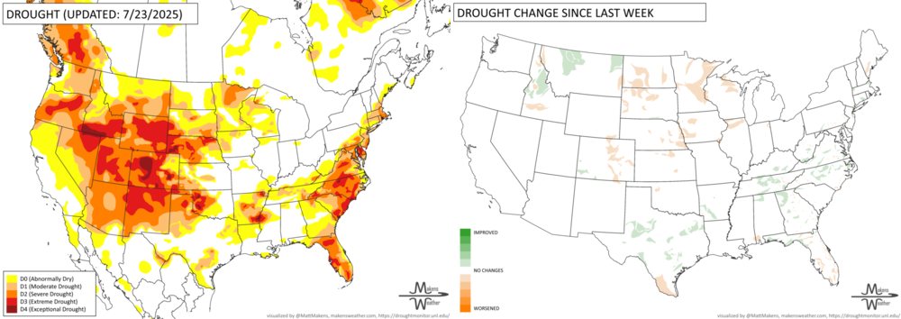
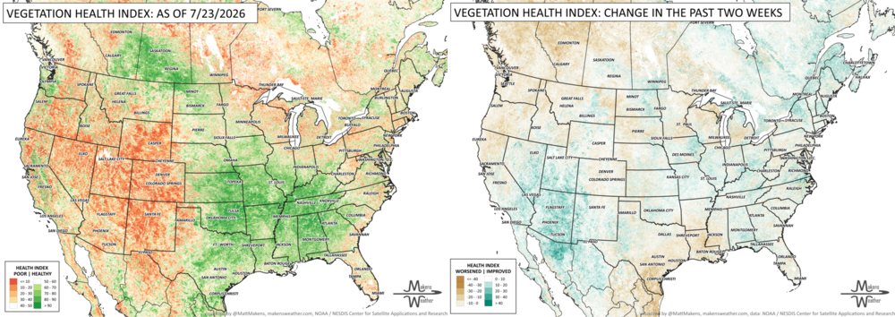
Drought conditions showed a mixed picture across the country this week. Drought expanded across parts of the Plains, Upper Midwest, and Florida as hot, dry weather continued, stressing crops and rangeland. Meanwhile, repeated rounds of heavy rain improved drought conditions across portions of Texas, the South, Southeast, Mid-Atlantic, and Northeast, although some areas experienced severe flash flooding. In the West, recent rainfall brought drought relief to parts of Idaho and Montana, while drought conditions worsened in eastern Colorado and southeastern Wyoming due to persistent heat and dry conditions. California's major reservoirs continue to hold near- or above-average water levels thanks to recent wet years, with both Lake Shasta and Lake Oroville at or above their normal storage for late July. However, the Colorado River Basin remains under significant stress. Lake Powell and Lake Mead are still well below normal levels, and the overall Colorado River system is only about one-third full, highlighting the region's ongoing long-term water challenges despite localized improvements elsewhere.
FIRE!
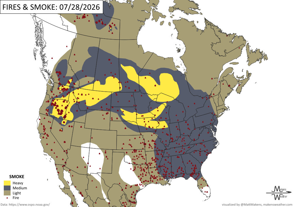
Firefighters are working to suppress and contain 95 large fires across the country, including 13 new large incidents since yesterday. 25,796 firefighters and support personnel are engaged in nationwide fire activity, including 569 crews, 1,534 engines, and 158 helicopters. So far this year, 42,379 fires have burned more than 4 million acres across the United States. Fire activity continues to be elevated in the Northwest Geographic Area, with 51 uncontained large fires and 18 Complex Incident Management Teams committed in Oregon and Washington. -NIFC
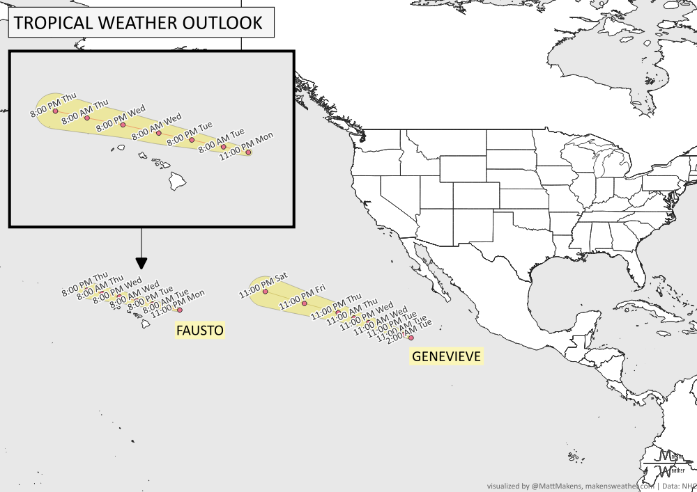
TRACKING THE TROPICS
The National Hurricane Center is issuing advisories on Tropical Storm Fausto, located in the Central Pacific several hundred miles east-northeast of the Hawaiian Islands, and on Hurricane Genevieve, located several hundred miles southwest of the southern tip of the Baja California Peninsula.
ARE YOU CIRRUS?!
In weather history:
1898: A severe thunderstorm produced considerable hail in Chicago, Illinois, business district. Some people were hurt, not by hail, but by several hundred runaway horses spooked by the hailstones.
1976: At 3:42 AM, an earthquake measuring between 7.8 and 8.2 on the Richter scale flattened Tangshan, a Chinese industrial city with a population of about one million people. An estimated 242,000 people in Tangshan and surrounding areas were killed, making the earthquake one of the deadliest in recorded history.
The weather pattern is about to make a pretty sharp turn across the country. California starts the week with unusual October heat, including highs well into the 90s and even lower 100s in the Central Valley. Meanwhile, much cooler fall air has reached the Great Lakes and Northeast. The Gulf Coast and Southeast stay unsettled, and there’s that record to watch: a tropical depression is likely to develop over the Gulf this week and could strengthen as it moves northeast. If it becomes a hurricane after the 8th, 2026 will have the latest-first hurricane in the Atlantic Basin record.