





Weekly Weather Watch: Tuesday, August 11th, 2026
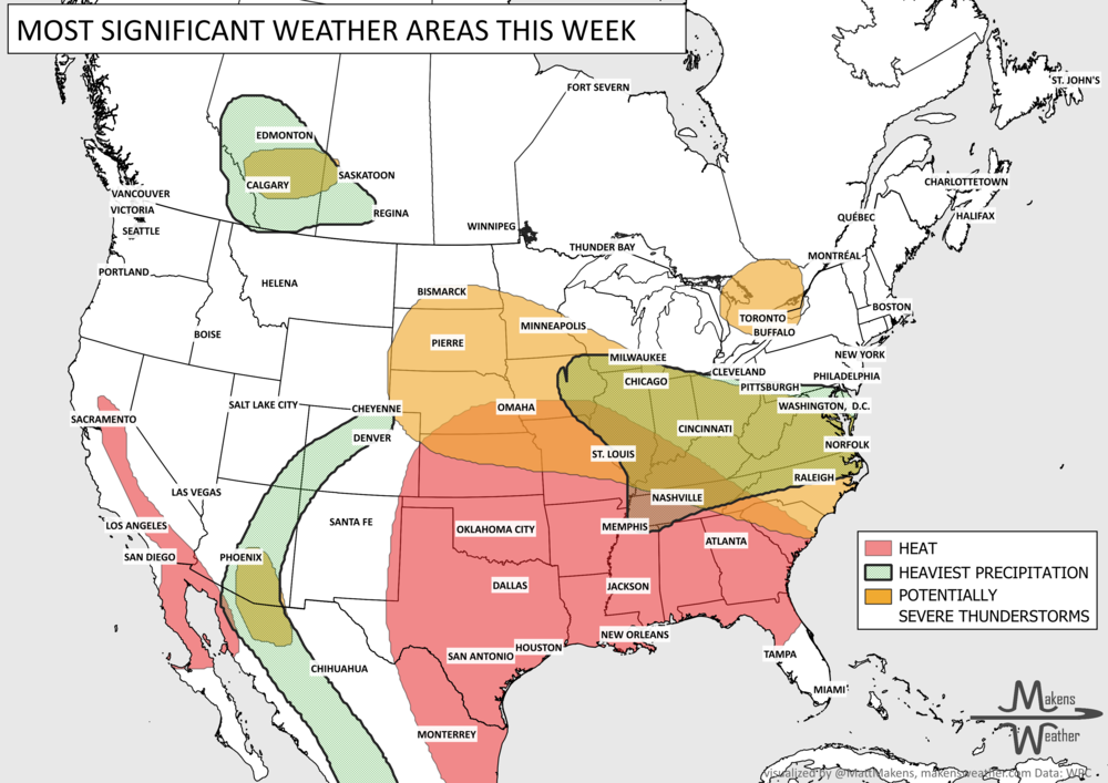
An active summer weather pattern will bring several areas to watch through early next week. The most immediate concern is across the Ohio Valley, where additional heavy rain falling on already saturated areas could produce considerable flash and urban flooding, while severe thunderstorms bring a damaging wind threat. Farther south, persistent heat and humidity will continue from the Southern Plains through the Southeast, with little overnight relief in some areas. Meanwhile, increasing monsoon moisture will bring repeated thunderstorms and a flash flood threat to the Southwest and Rockies, while additional rounds of storms and heavy rain remain possible from the Central Plains and Midwest into the East later this week.
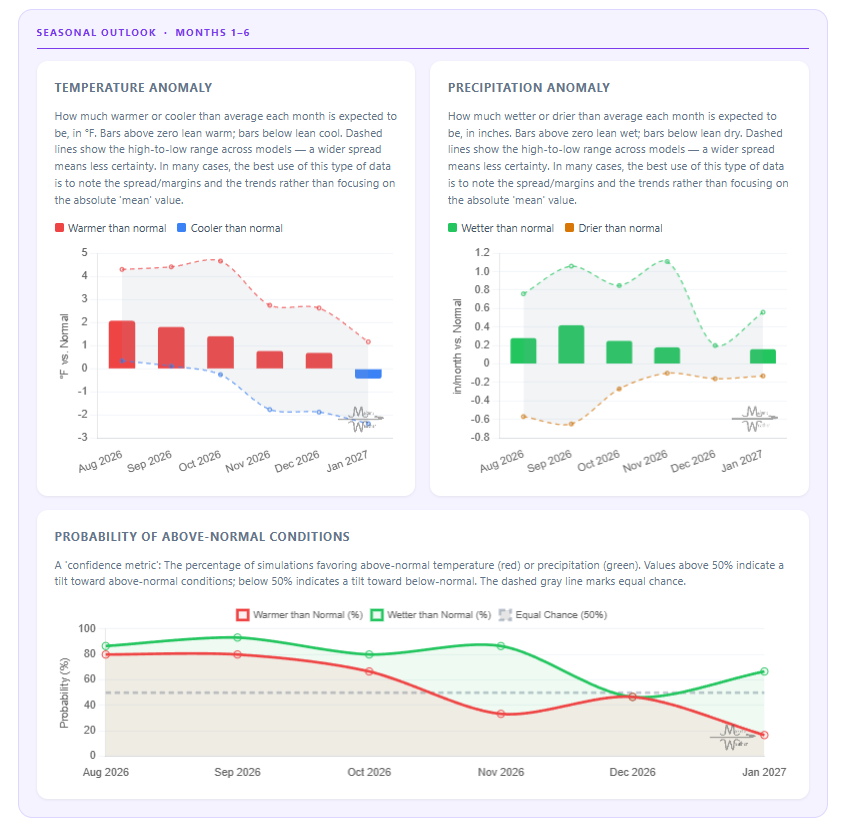
UPDATED YESTERDAY! SEASONAL OUTLOOKS☀️📊
Know What's Coming — For Your Exact Location
Most seasonal outlooks give you a broad regional brushstroke. The Makens Weather Seasonal Forecast App gives you a point forecast for your location — temperature and precipitation outlooks for the next six months, updated every morning.
Your address, not a region: Enter your location once. Every month, the latest consensus forecast is waiting for you.
Weeks 1–4 near-term: Refreshes daily, so short-range planning and seasonal planning live in the same place.
Not just the mean: Charts show the full model spread so you can see how confident the ensemble is, not just which direction it's leaning.
Probability metrics: Know whether 60% or 90% of simulations favor above-normal temperatures. Confidence matters as much as the forecast itself.
If you're making decisions that depend on what the next few months look like — planting windows, input purchases, grazing plans, contract timing — this is the tool that bridges the gap between "what's the general trend" and "what should I actually expect at my operation."
📈 The latest weekly and monthly outlooks 👉 Join Now to Access
HEADLINERS:
Next 7 Days: Key Timing and Impacts
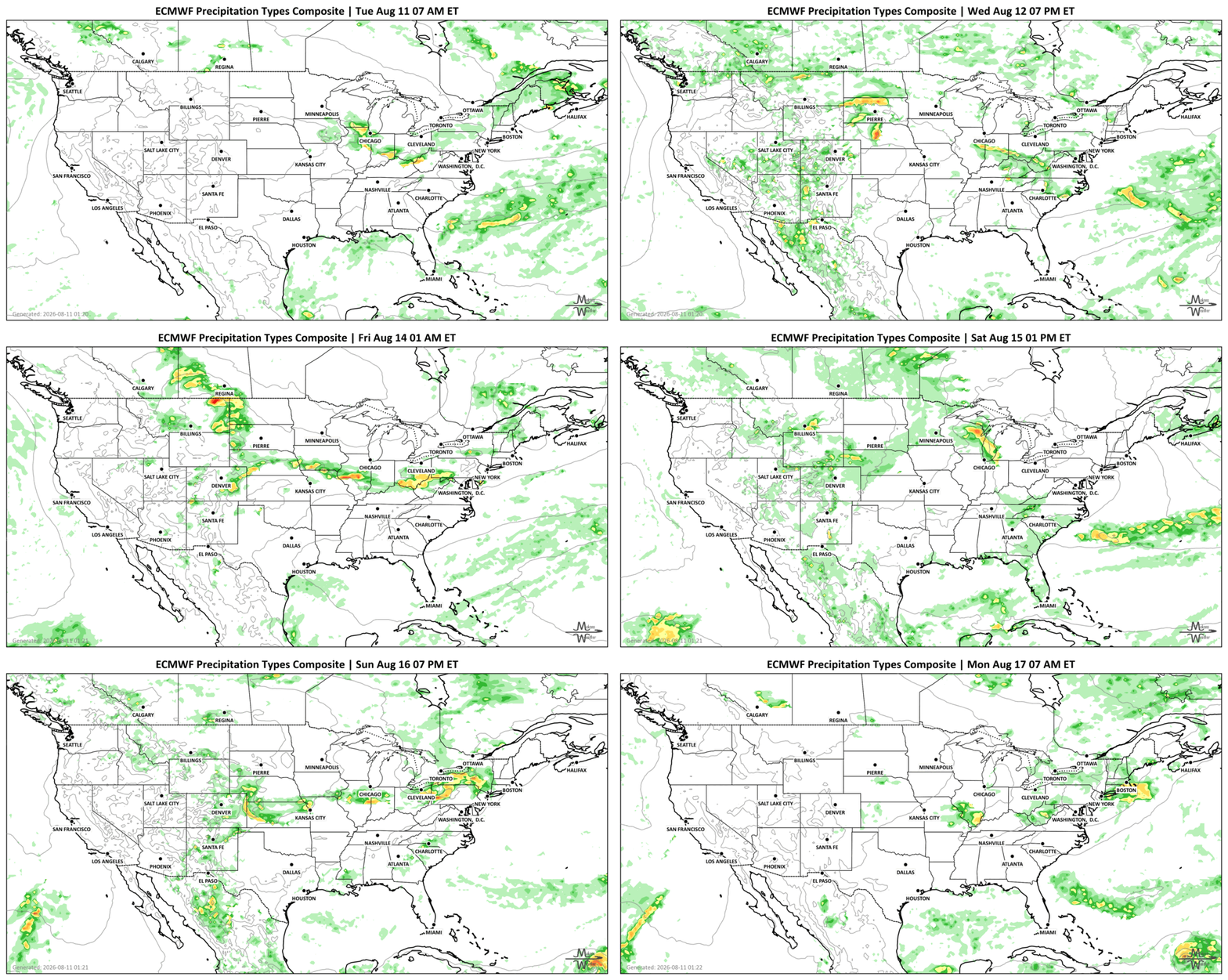
Tuesday, August 11: The most significant flooding concern centers on the Ohio Valley, where another 2–4 inches of rain could affect areas already hit by flooding. Severe thunderstorms capable of damaging winds are also possible from northern Illinois and the mid-Mississippi Valley into the Ohio Valley and central Appalachians. The Northern High Plains could see scattered severe storms, including hail. Central to southern interior areas of British Columbia will have ongoing wildfire issues resulting in degraded air quality. Isolated heavy rainfall in Southwestern Alberta.
Wednesday, August 12: Heavy rain remains a concern from the Midwest and lower Great Lakes into the Ohio Valley, although the severe weather threat should become less prominent. Monsoon thunderstorms across southern Arizona could produce locally heavy rain and flash flooding. Isolated heavy rainfall in Southern Alberta to Southwestern Saskatchewan.
Thursday, August 13: Heat continues from the Central Plains into the Southeast, while a notable change develops farther west. Temperatures across portions of the Intermountain West could fall 10–20 degrees as cooler air, clouds and precipitation spread into the region. Heavy rainfall in Southern Alberta.
Friday, August 14: Attention increasingly turns to the Southwest and south-central Rockies, where slow-moving monsoon thunderstorms could produce excessive rainfall and flash flooding. Burn scars, slot canyons and urban areas will be particularly vulnerable. Another corridor of heavy rain may develop across the Corn Belt and Midwest. Heavy rainfall in Southern Saskatchewan.
Saturday, August 15: Monsoon thunderstorms remain active across the Southwest, Great Basin and Rockies, maintaining localized flash flooding concerns. Additional showers and thunderstorms could bring locally heavy rainfall from the Central Plains and Midwest toward the Ohio and Tennessee Valleys. Isolated heavy rainfall in Southern Manitoba.
Sunday, August 16: The persistent summer pattern continues. Periodic storm clusters remain possible from the north-central U.S. through the Midwest and toward the East, while the South-Central U.S. and Southeast continue dealing with significant heat and humidity.
Monday into Tuesday, August 17–18: There is little indication of a major pattern change. The Southern Plains and Southeast remain under persistent heat, while disturbances moving across the northern U.S. could continue triggering thunderstorms and pockets of heavy rainfall from the Central Plains and Midwest toward the East.
SET YOUR WATCHES - WHEN THE MOISTURE ARRIVES:
Damaging wind gusts are the primary concern today from northern Illinois and the mid-Mississippi Valley through the Ohio Valley, with storms extending toward the central Appalachians. The Northern High Plains also face scattered severe storms and a hail threat.
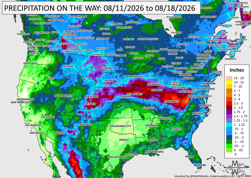
IN THE GAUGES, PRECIPITATION THROUGH THE 18th:
Note: these projected totals are likely to be over/under-done in many areas because thunderstorms will be the primary source of rainfall, and we know what they can do.
Ohio Valley: This is the most immediate concern. Additional rainfall of 2–4 inches today could fall near locations already inundated by previous flooding. That increases the potential for rapid flash flooding and flooding in urban areas.
Southwest and Rockies: The monsoon becomes increasingly important later this week. Slow-moving and repeated thunderstorms across the Southwest, Great Basin and Rockies could produce intense rainfall over short periods. Burn scars, slot canyons and urban areas will be among the most vulnerable locations.
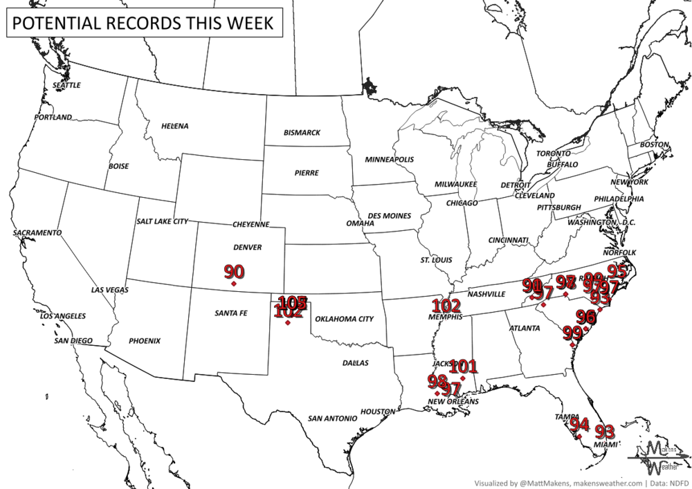
RECORDS MADE TO BE BROKEN, DAILY HIGHS (RED) | DAILY LOWS (BLUE):
Persistent heat becomes the longer-duration story. Parts of the Southern Plains could reach the lower 100s, while widespread 90s continue across the Southeast. High humidity will make conditions feel hotter, and unusually warm nights may provide limited relief.
UN-DROUGHTABLY DRY:
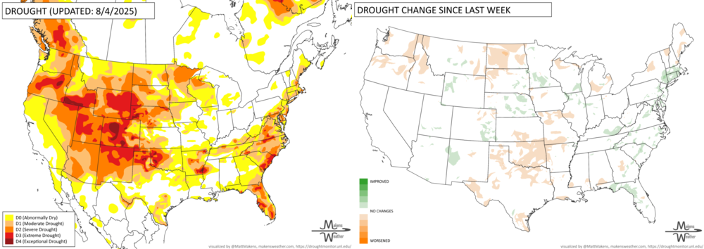
Widespread rain brought drought improvement to much of the Eastern Seaboard, Midwest, Great Lakes and parts of the central Plains this week, although longer-term water supply and groundwater concerns remain in some areas. Conditions were more mixed farther west and south, with heat and dryness worsening drought across parts of the Great Plains, particularly from southern Kansas into Texas. Monsoon rainfall provided localized relief in Arizona and New Mexico, but much of the West remained dry. Drought also intensified across Puerto Rico, while new areas of dryness developed in Hawaii and Alaska.
FIRE!
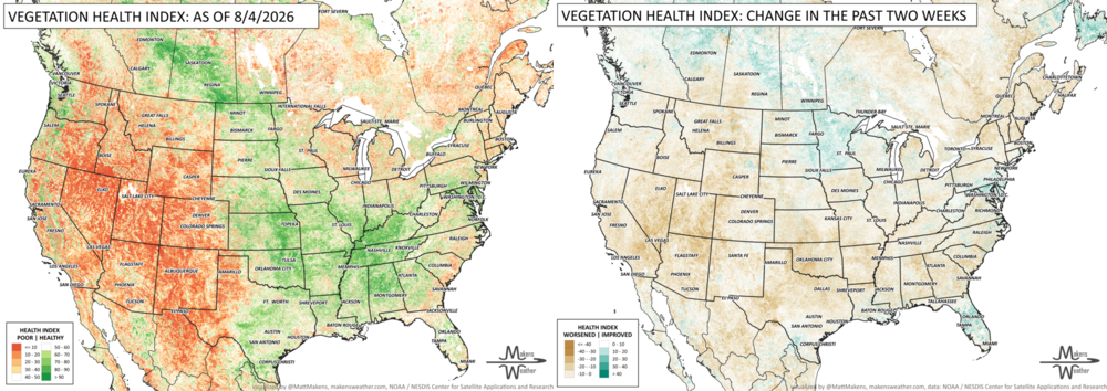
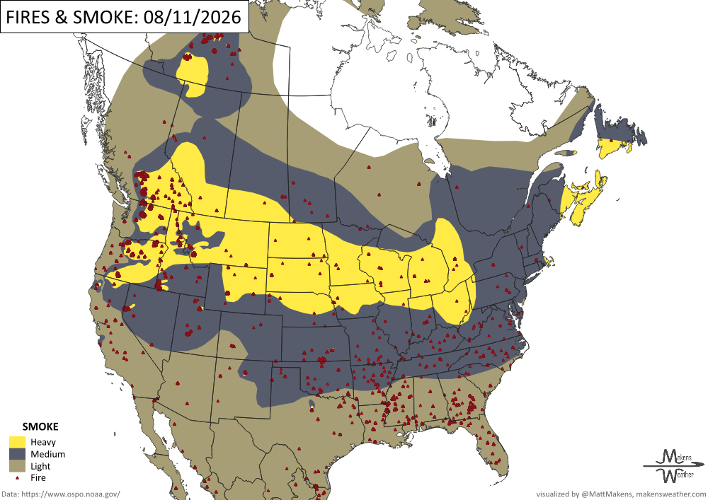
Wildfire activity remains elevated nationwide, with 98 uncontained large fires and nearly 30,000 personnel assigned as the National Preparedness Level remains at its highest level. The Northwest is the most active region, where extreme fire behavior in Oregon and Washington is prompting evacuations, road closures, and threats to homes and critical infrastructure. -NIFC
TRACKING THE TROPICS
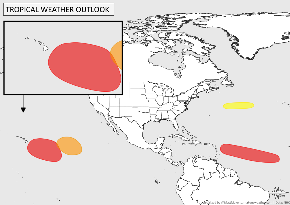
Atlantic: The main feature to watch is an area of low pressure about 500 miles southwest of the Cabo Verde Islands, where conditions are expected to become increasingly favorable for development. A tropical depression is likely to form later this week as the system moves west to west-northwest across the central tropical Atlantic, with the NHC indicating a high chance of development within seven days.
Pacific: The main feature to watch in the eastern Pacific is a broad area of disorganized showers and thunderstorms well west-southwest of the southern tip of Baja California. Conditions appear favorable for gradual development, and a tropical depression could form within the next few days as the system moves slowly northwestward, with increasing winds and seas expected over the west-central eastern Pacific by midweek.
ARE YOU CIRRUS?!
In weather history:
1940 - Hurricane Strikes the Southeast: A Category 2 hurricane made landfall along the Georgia and South Carolina coast, producing a 13-foot storm tide in South Carolina and more than 15 inches of rain across northern North Carolina. As the storm slowly moved through the Southeast, significant flooding and landslides affected Georgia, North Carolina, Tennessee, and Virginia. The storm caused $13 million in damage and resulted in 50 deaths.
1999 - Historic Salt Lake City Tornado: An F2 tornado struck the Salt Lake City metropolitan area, remaining on the ground for about 10 minutes. The tornado killed one person, injured more than 80, and caused over $170 million in damage, making it the most destructive tornado in Utah history.
The weather pattern is about to make a pretty sharp turn across the country. California starts the week with unusual October heat, including highs well into the 90s and even lower 100s in the Central Valley. Meanwhile, much cooler fall air has reached the Great Lakes and Northeast. The Gulf Coast and Southeast stay unsettled, and there’s that record to watch: a tropical depression is likely to develop over the Gulf this week and could strengthen as it moves northeast. If it becomes a hurricane after the 8th, 2026 will have the latest-first hurricane in the Atlantic Basin record.