





Weekly Weather Watch: Tuesday, August 18th, 2026
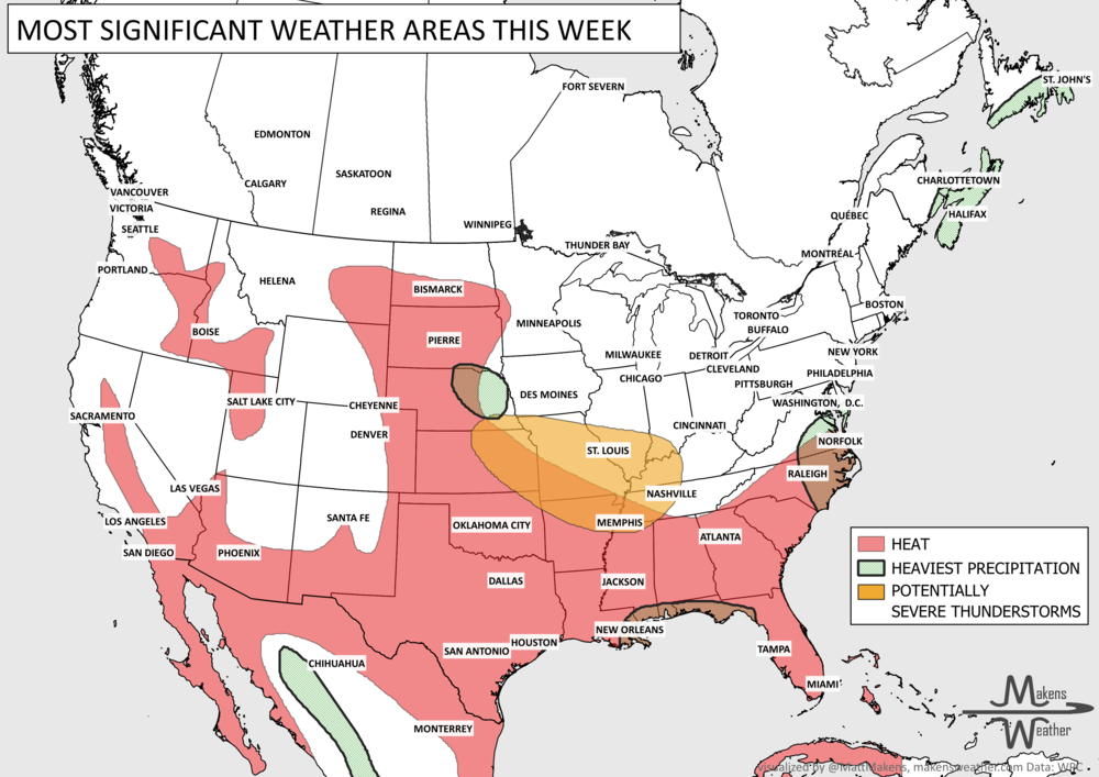
The main weather story this week is a sharp split between stormy weather across the nation’s midsection and persistent summer heat farther south. Severe thunderstorms threaten parts of the central Plains and Lower Missouri Valley through tonight, with large hail, damaging winds and locally heavy rain possible. Another round of strong storms shifts toward the mid-Mississippi Valley Wednesday. Meanwhile, dangerous heat continues from the southern Plains through the Southeast, while expanding back into the Southwest. Later in the week, the Southeast finally gets some relief, but the heat hangs on farther west.
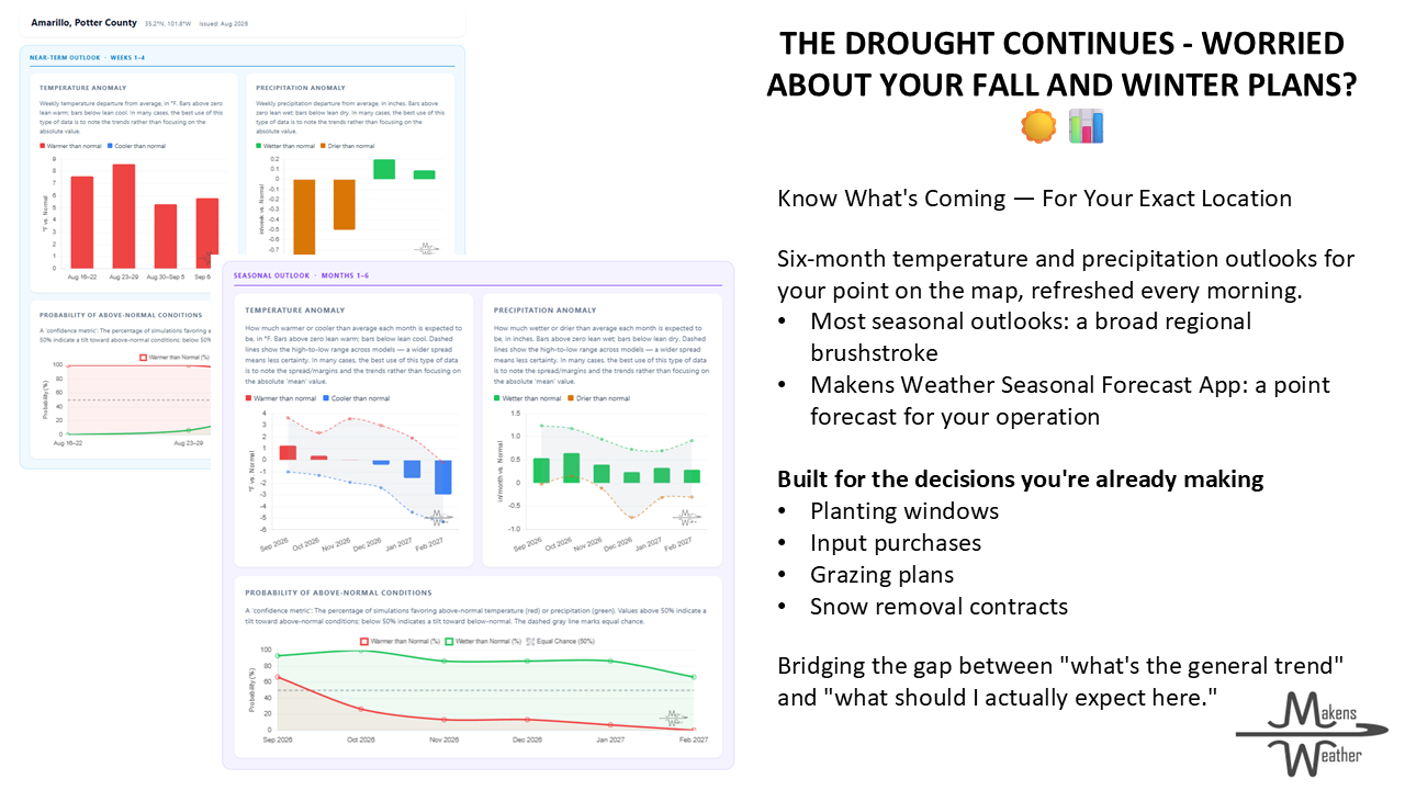
📈 The latest weekly and monthly outlooks 👉 Join Now to Access
HEADLINERS:
What to watch:
Tuesday, Aug. 18: Severe thunderstorms develop across the central Plains, especially from Nebraska and northern Kansas east toward the Lower Missouri Valley and Midwest. Large hail, damaging winds and locally heavy rainfall are the main concerns. Dangerous heat continues across the southern Plains and Southeast and builds into the Desert Southwest.
Wednesday, Aug. 19: Another round of strong to severe thunderstorms develops from the central Plains into the mid-Mississippi Valley, with the greater severe-weather concern arriving later Wednesday and Wednesday night. Heat remains intense across the South and Southwest. Pockets of heavy rainfall in Quebec and the Maritimes.
Thursday, Aug. 20: The overall pattern begins shifting east. Showers and thunderstorms remain possible from the central U.S. toward the Ohio Valley and East, while persistent heat remains a concern across the southern tier. Pockets of heavy rainfall remain in the Maritimes.
Friday, Aug. 21: Rain and thunderstorms become more widespread across portions of the Mid-Atlantic and Southeast, with isolated flash flooding possible. Another area of rain and storms crosses the Upper Midwest and Great Lakes. The southern Plains, Lower Mississippi Valley and Southwest remain hot.
Saturday, Aug. 22: Rain chances continue along the Eastern Seaboard, while the Southeast starts getting some relief from the prolonged heat. Monsoon thunderstorms continue across the Southwest and Intermountain West, where localized flash flooding could occur. Rain also reaches parts of the Pacific Northwest and northern Rockies. Some heavy rainfall in British Columbia. Gusty winds for Alberta and Saskatchewan.
Sunday, Aug. 23: A cooler pattern becomes more established across the East, with unsettled weather around the Great Lakes, Appalachians and East Coast. Heat remains firmly established across the south-central U.S. and Southwest. Gusty winds for Alberta and Saskatchewan.
Monday-Tuesday, Aug. 24-25: The greatest heat concerns remain across the southern Plains and Lower Mississippi Valley, extending west toward the Southwest. Scattered thunderstorms continue across the West, while additional rounds of rain and storms could affect portions of the northern and central Plains and Mississippi Valley, although their exact placement remains uncertain.
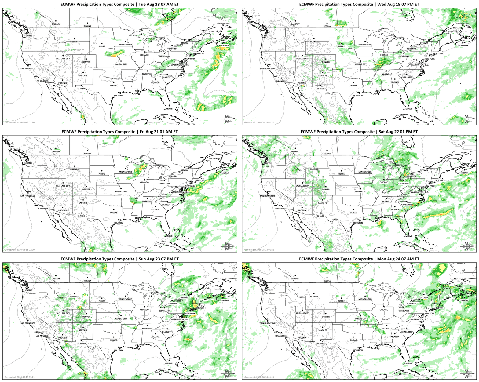
SET YOUR WATCHES - WHEN THE MOISTURE ARRIVES:
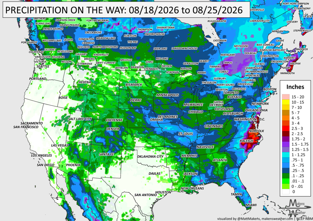
IN THE GAUGES, PRECIPITATION THROUGH THE 25th:
Note: these projected totals are likely to be over/under-done in many areas because thunderstorms will be the primary source of rainfall, and we know what they can do.
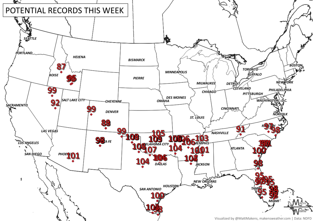
RECORDS MADE TO BE BROKEN, DAILY HIGHS (RED) | DAILY LOWS (BLUE):
UN-DROUGHTABLY DRY:
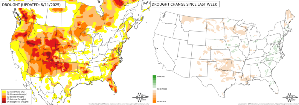
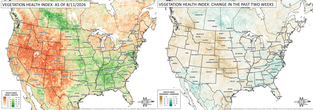
Rainfall varied widely across the country this past week. The heaviest rain focused on parts of the Ohio Valley and central Appalachians, where widespread totals topped 2 inches and localized areas from Indiana through Ohio and West Virginia picked up 5 to 7 inches. Parts of Missouri also received several inches, while scattered heavier rain fell across the Upper Midwest, Southeast and Florida. Monsoon moisture brought pockets of rain to the Desert Southwest, but much of the West, Rockies and Plains remained dry. Temperatures ran warmer than normal across much of the West and southern Plains, with some areas from the Great Basin through Oklahoma and western Texas running 6 to 10°F above average. The Northeast, particularly New England, was also unusually warm. Cooler-than-normal conditions were concentrated across the northern Plains, while temperatures elsewhere were generally closer to typical mid-August levels.
FIRE!
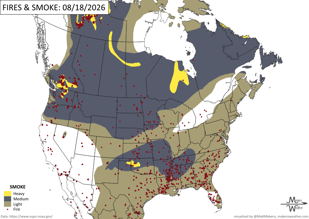
Wildfire activity remains elevated across the country, with 80 large fires still uncontained and nearly 29,000 personnel assigned as of August 17. The Northwest remains the busiest region, accounting for 37 of those fires, with several incidents in Washington and Oregon threatening communities and infrastructure. Significant fire activity also continues in the Great Basin, including fires in Utah that have prompted evacuations and closures. So far this year, nearly 49,000 wildfires have burned more than 7.2 million acres nationwide, well above the 10-year average for both the number of fires and acres burned. -NIFC
TRACKING THE TROPICS
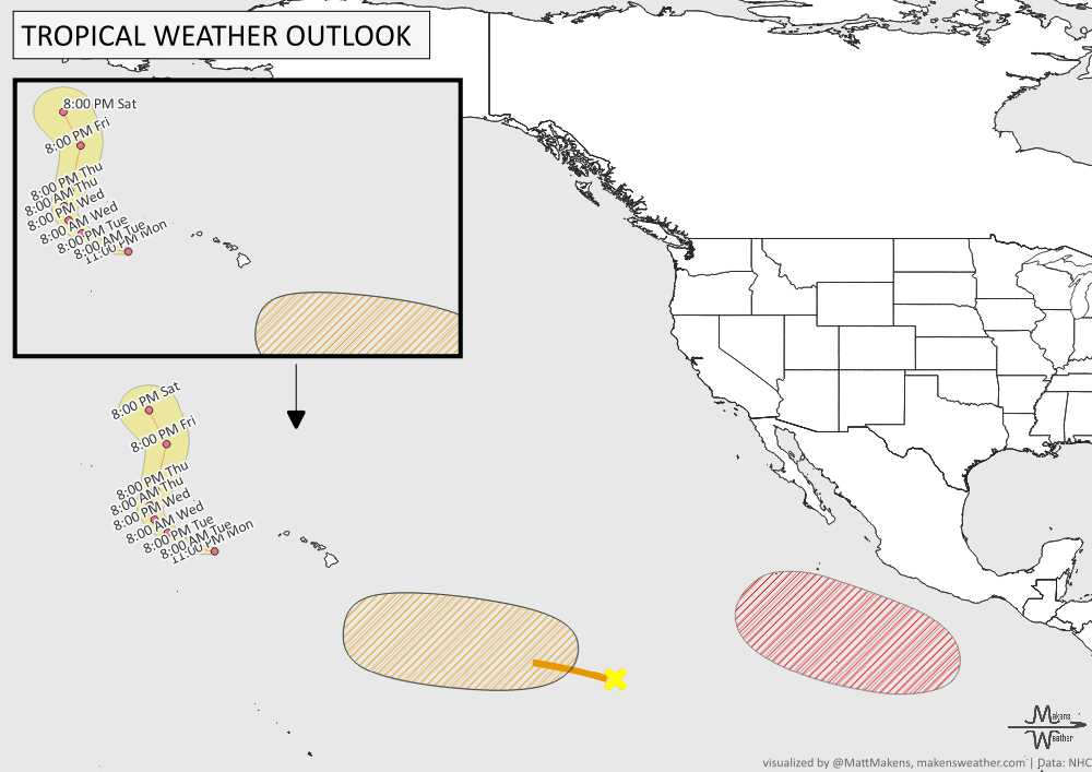
Tropical activity remains active across the Pacific. Hurricane Lala is currently located a few hundred miles south-southwest of French Frigate Shoals, Hawaii. Farther east, an area of low pressure is expected to develop well south of Mexico later this week, with an 80% chance of becoming a tropical depression this weekend as it remains offshore and moves west-northwest. Another disturbance well southwest of Baja California also has the potential to develop as it tracks westward, with a 60% chance of formation during the next seven days.
ARE YOU CIRRUS?!
In weather history:
1925: During the late morning hours, a severe hailstorm struck southeastern Iowa, destroying crops along a path six to ten miles wide and 75 miles long. The hail also injured and killed poultry and livestock and caused $2.5 million in damage. The hailstorm flattened fields of corn to such an extent that many had to leave their farms in search of other work.
1931: The Yangtze River in China peaks during a horrible flood that kills 3.7 million people directly and indirectly over the next several months. This flood was perhaps the worst natural disaster of the 20th century.
The weather pattern is about to make a pretty sharp turn across the country. California starts the week with unusual October heat, including highs well into the 90s and even lower 100s in the Central Valley. Meanwhile, much cooler fall air has reached the Great Lakes and Northeast. The Gulf Coast and Southeast stay unsettled, and there’s that record to watch: a tropical depression is likely to develop over the Gulf this week and could strengthen as it moves northeast. If it becomes a hurricane after the 8th, 2026 will have the latest-first hurricane in the Atlantic Basin record.