





Weekly Weather Watch: Tuesday, August 25th, 2026
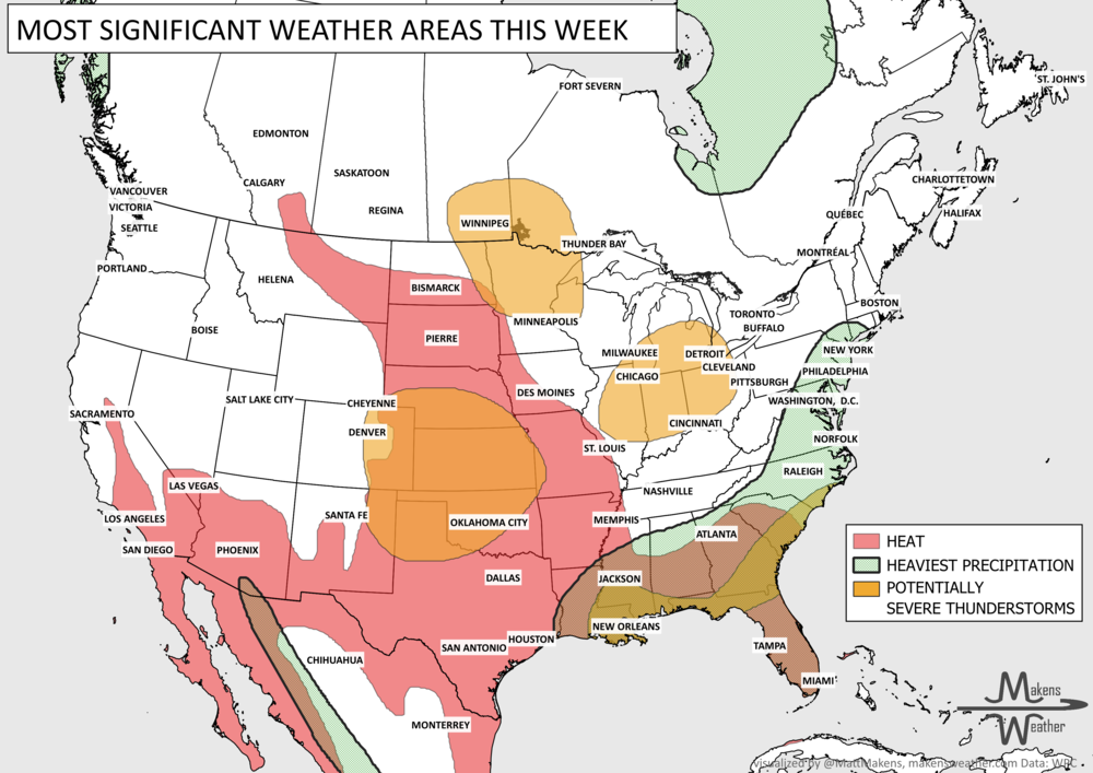
Late August is bringing two very different weather stories across the country. Dangerous heat remains locked in from the Desert Southwest into Texas and the Southern Plains, with little relief at night. To the north and east, a more active storm track will bring rounds of thunderstorms from the Plains into the Midwest and Great Lakes, including some severe storms and locally heavy rain. Monsoon moisture will also keep scattered thunderstorms going across the Four Corners and Rockies, where isolated flash flooding remains possible. By the weekend, the heat begins expanding farther east toward the Lower Mississippi Valley and Mid-South. Thunderstorms with heavy rainfall in parts of central to eastern Canada, with ongoing air quality issues in western Canada.
📈 The latest weekly and monthly outlooks 👉 Join Now to Access
HEADLINERS:
What to watch:
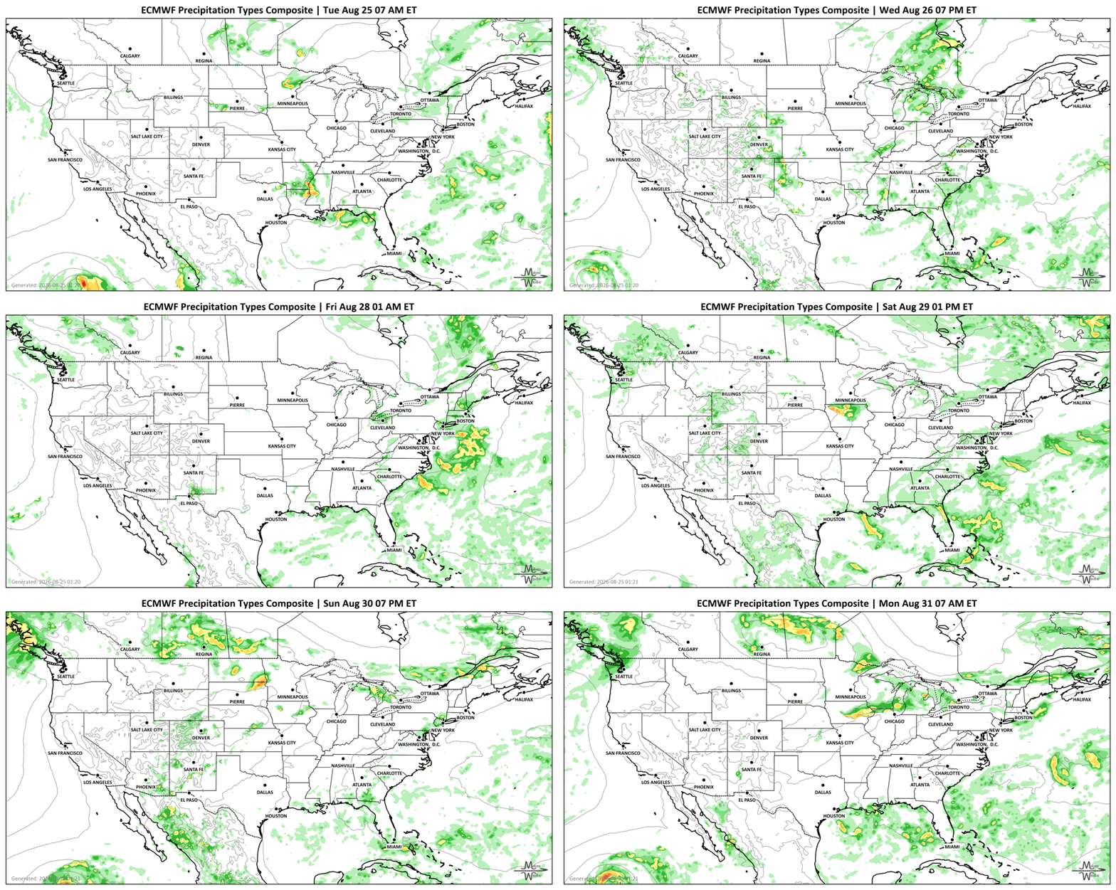
Tuesday, August 25: Strong to severe thunderstorms develop from the central and southern Plains into the Upper Midwest. Locally heavy rain could produce isolated flash flooding. Monsoon thunderstorms continue across the Four Corners and central Rockies. Air quality issues for parts of British Columbia due to wildfire smoke. Chance of severe thunderstorms in parts of Manitoba and Ontario. Strong wind gusts in Saskatchewan.
Wednesday, August 26: The storm threat shifts east toward the Great Lakes and Ohio Valley. Additional thunderstorms across the High Plains, Southeast and Lower Mississippi Valley may bring damaging winds and pockets of heavy rain. Ongoing air quality issues for parts of British Columbia due to wildfire smoke. Ongoing risk of severe weather and heavy rainfall for Ontario.
Tuesday through Thursday: Dangerous heat remains the main concern from the Desert Southwest through Texas and the Southern Plains. Highs reach well above 100°F in many areas, with some Southwest deserts approaching 115°F. Warm nights will provide limited relief. Heavy rainfall in parts of Quebec and the Maritimes. Strong wind gusts in Alberta and Saskatchewan.
Friday and Saturday: Monsoon thunderstorms continue across parts of the Southwest, Intermountain West and Rockies. Most areas won't see flooding, but heavier storms could cause problems near burn scars, slot canyons, steep terrain and urban areas. Ongoing heavy rainfall in parts of Quebec and the Maritimes.
Friday into the weekend: Additional rounds of thunderstorms are possible from the Plains into the Midwest as disturbances move along the northern edge of the heat ridge. Some storms could produce locally heavy rain.
Weekend into early next week: The core of the heat shifts east. Hazardous heat remains across the Southern Plains and expands into the Lower Mississippi Valley and Mid-South.
Through early next week: A slow-moving front keeps periods of showers and thunderstorms around the Southeast, especially near the coast. Repeated storms could produce localized heavy rainfall.
SET YOUR WATCHES - WHEN THE MOISTURE ARRIVES:
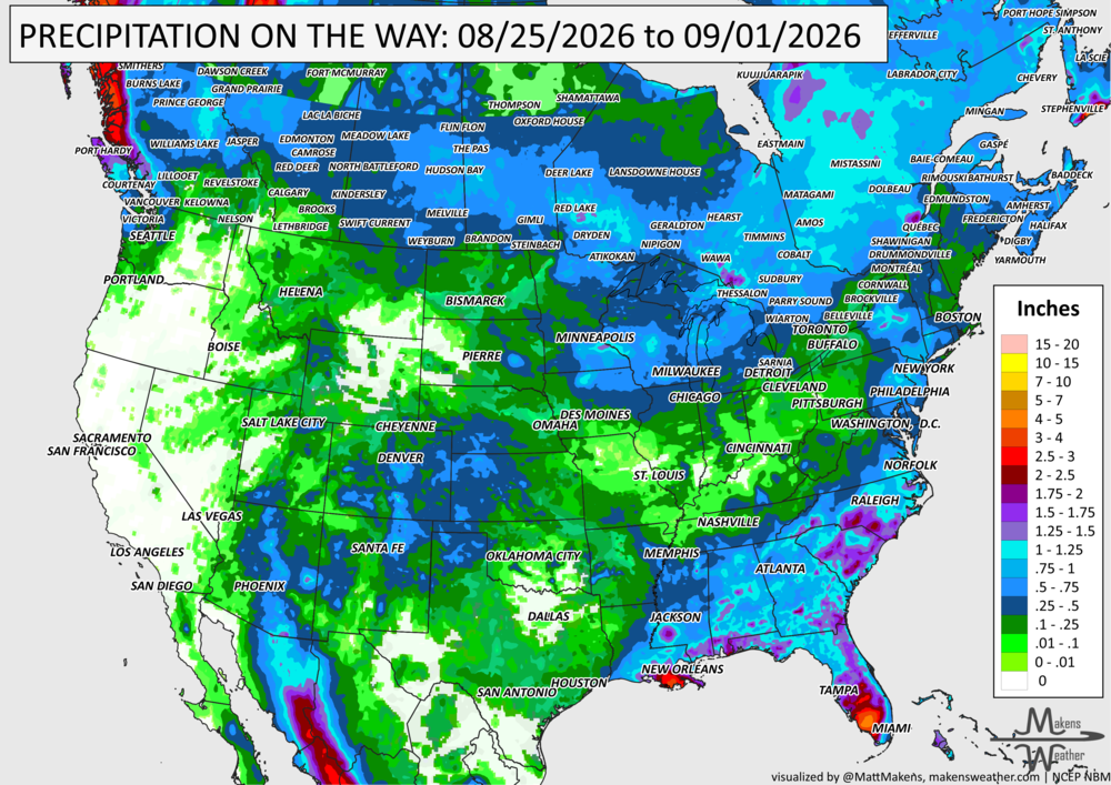
IN THE GAUGES, PRECIPITATION THROUGH THE 1st:
Note: these projected totals are likely to be over/under-done in many areas because thunderstorms will be the primary source of rainfall, and we know what they can do.
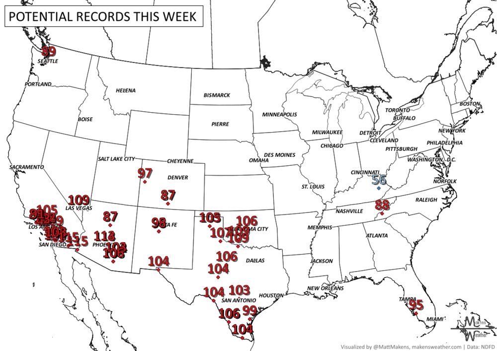
RECORDS MADE TO BE BROKEN, DAILY HIGHS (RED) | DAILY LOWS (BLUE):
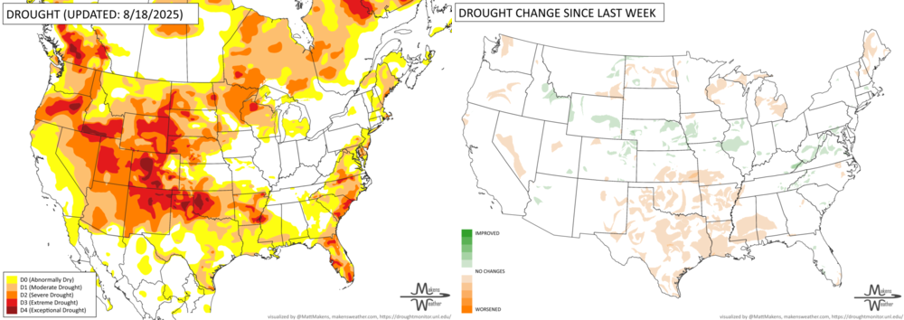
UN-DROUGHTABLY DRY:
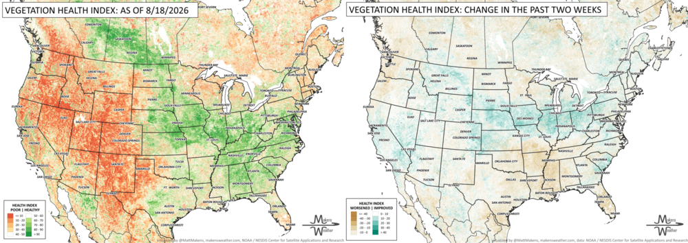
Rain brought some drought relief this week from the central Plains into the Midwest, with especially heavy totals in Illinois and Indiana. The northern Plains, central High Plains and parts of the Southwest also picked up beneficial moisture. Meanwhile, dry and unusually hot weather continued across the southern Plains and lower Mississippi Valley, while much of the West Coast, Michigan and Wisconsin saw little rainfall.
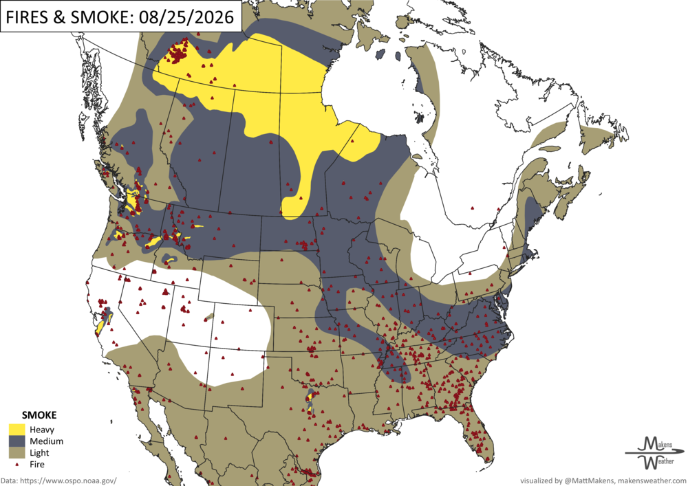
FIRE!
Wildfire activity remains elevated across the United States, with 86 large fires currently burning and more than 22,000 firefighters and support personnel assigned. The Northwest continues to see the greatest overall activity, while six new large fires in the Southern U.S. show how quickly conditions can shift between regions. So far this year, more than 7.8 million acres have burned nationwide, well above the 10-year average. -NIFC
TRACKING THE TROPICS
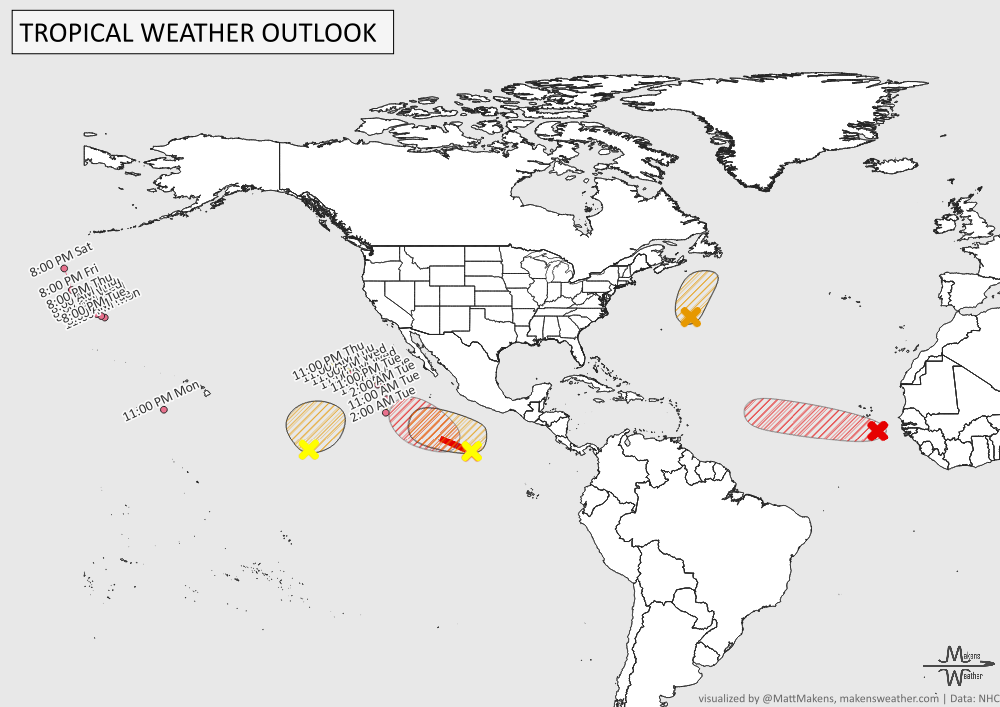
Tropical activity is busy across both the Atlantic and Pacific. In the Atlantic, a system near Bermuda has a 40% chance of briefly developing before conditions become less favorable, while another system near the Cabo Verde Islands has a 70% chance of becoming a tropical depression within the next couple of days. In the Pacific, Tropical Storms Lala, Iselle and Julio remain active, with additional areas being monitored. Development appears especially likely well south of Mexico, where one system has a 90% chance of becoming a tropical depression during the next seven days. -NHC
ARE YOU CIRRUS?!
In weather history: Two notable tornadoes occurred on this date. In 1814, a powerful tornado tore through Washington, D.C., damaging and destroying homes just one day after British troops burned major government buildings. Heavy rain helped extinguish the fires, while the tornado killed or injured dozens. In 1948, an estimated F2 tornado struck Hamilton, New Zealand, killing three people, injuring dozens and damaging nearly 200 homes and businesses.
The weather pattern is about to make a pretty sharp turn across the country. California starts the week with unusual October heat, including highs well into the 90s and even lower 100s in the Central Valley. Meanwhile, much cooler fall air has reached the Great Lakes and Northeast. The Gulf Coast and Southeast stay unsettled, and there’s that record to watch: a tropical depression is likely to develop over the Gulf this week and could strengthen as it moves northeast. If it becomes a hurricane after the 8th, 2026 will have the latest-first hurricane in the Atlantic Basin record.