





Weekly Weather Watch: Tuesday, September 1st, 2026
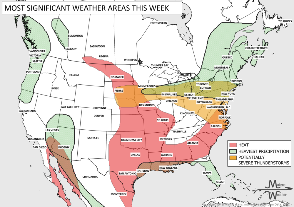
The main story this week is a sharp contrast across the country. Tropical Storm Edouard brings heavy rain, coastal flooding concerns and strong winds to Upper Texas and southwestern Louisiana through Wednesday, while rounds of thunderstorms may produce severe weather and localized flash flooding from the Great Lakes and Northeast into the Mid-Atlantic. Meanwhile, a stubborn late-summer heat wave holds across the Central and Southern Plains and spreads east before a cold front brings some relief this weekend. Out West, the Pacific Northwest stays unusually cool and showery, while monsoonal moisture increases the chance for locally heavy rain and flash flooding across the Southwest. Some snow for the Canadian Rockies surrounded by heavy rainfall and heat elsewhere in Canada.

📈 The latest weekly and monthly outlooks 👉 Join Now to Access
HEADLINERS:
What to watch:
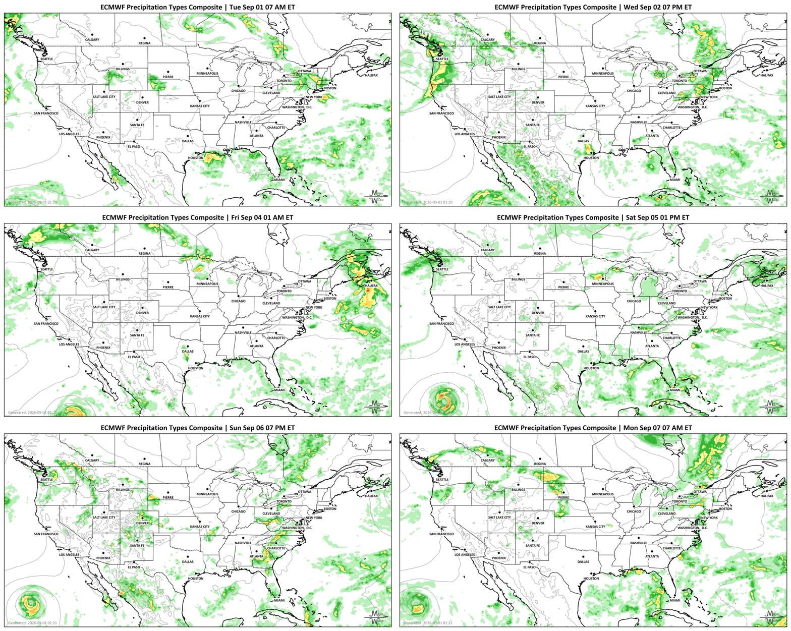
Tuesday, Sept. 1: Tropical Storm Edouard brings heavy rain, strong winds and coastal flooding concerns to Upper Texas and southwestern Louisiana. Severe thunderstorms are also possible from the Northern and Central Plains into the Upper Mississippi Valley, Great Lakes and Northeast. Monsoonal thunderstorms continue across the Southwest and Rockies. Heavy rainfall for parts of Coastal British Columbia, central Manitoba, and Ontario. Hot in southern Alberta and Saskatchewan..
Wednesday, Sept. 2: Edouard moves into southeastern Texas and weakens, but heavy rain and localized flash flooding remain concerns along the western Gulf Coast. Farther north and east, severe thunderstorms and heavy rainfall are possible from the Lower Great Lakes and Northeast into the northern Mid-Atlantic. Heavy rainfall for coastal British Columbia, and Quebec.
Thursday, Sept. 3: Heat becomes more widespread from the Central and Southern Plains and Mississippi Valley into the Ohio and Tennessee valleys and Mid-Atlantic. Showers continue across the Pacific Northwest, while scattered thunderstorms remain possible along the Southeast and Gulf coasts. Heavy rainfall near the Peace Region toward Edmonton, Alberta and the Maritimes.
Friday, Sept. 4: A cold front brings another round of thunderstorms from the Midwest through the Ohio Valley and central Appalachians into the Mid-Atlantic. Some storms could produce damaging winds, hail and locally heavy rainfall. Heavy precipitation falls on the Canadian Rockies.
Saturday, Sept. 5: Thunderstorms shift farther south into the Carolinas, while cooler air begins spreading into parts of the Mid-Atlantic and Southeast. Heat remains firmly established across the Central and Southern Plains.
Sunday-Monday, Sept. 6-7: Persistent late-summer heat continues across much of the central U.S. Meanwhile, moisture increases across the Southwest and Intermountain West, raising the risk for locally heavy monsoonal thunderstorms and flash flooding. Isolated heavy rainfall for southern Manitoba and Ontario.
Into Tuesday, Sept. 8: The overall pattern remains divided, with persistent heat across the central U.S., cool and unsettled weather in the Pacific Northwest, and continued opportunities for monsoonal rainfall across the Southwest.
SET YOUR WATCHES - WHEN THE MOISTURE ARRIVES:
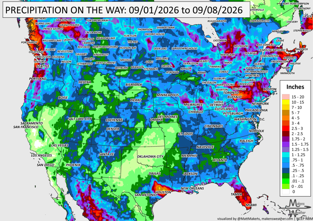
IN THE GAUGES, PRECIPITATION THROUGH THE 8TH:
Note: these projected totals are likely to be over/under-done in many areas because thunderstorms will be the primary source of rainfall, and we know what they can do.
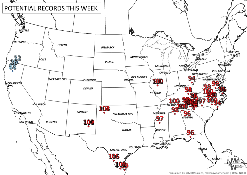
RECORDS MADE TO BE BROKEN, DAILY HIGHS (RED) | DAILY LOWS (BLUE):
UN-DROUGHTABLY DRY:
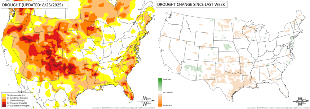
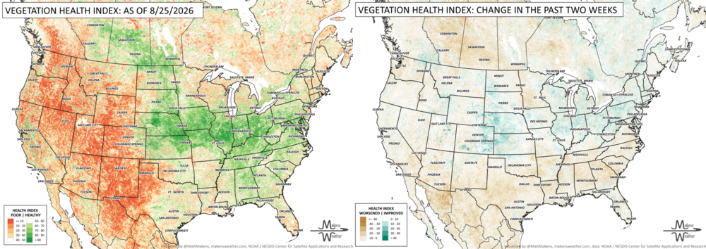
Last week brought widespread late-summer heat and expanding drought, especially across the South and West, where hot and mostly dry conditions quickly depleted moisture. Storms produced pockets of heavy rain from the Central Plains and Corn Belt into the Mid-Atlantic and New England, while monsoon thunderstorms provided localized relief in Arizona and New Mexico. Drought improved in parts of Alaska, recent tropical systems boosted rainfall across Hawaii, and continued dry conditions led to further drought expansion in Puerto Rico.
FIRE!
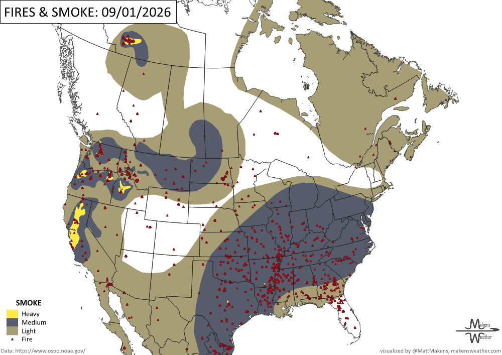
As of August 31, wildfire activity remains high across the United States, with 93 large fires burning and more than 22,000 personnel assigned. More than 8.2 million acres have burned so far this year, well above the 10-year average. Fire activity has eased somewhat in the Northwest, but elevated fire danger continues across North Central Texas, Southwest Idaho and the Pacific Northwest, and the nation remains at the highest preparedness level. -NIFC
TRACKING THE TROPICS
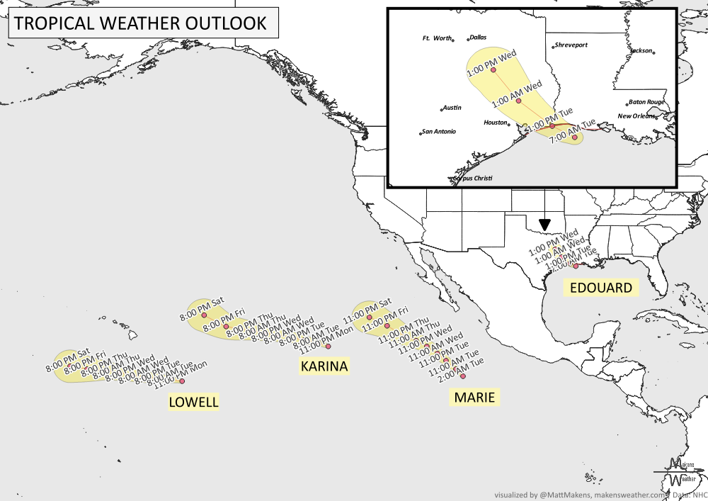
The main tropical concern is Tropical Storm Edouard, which is moving toward the Louisiana-Texas border and is expected to strengthen before making landfall tonight. Tropical-storm conditions, storm surge, rough seas and heavy thunderstorms will affect portions of the northwest Gulf Coast, with Edouard forecast to weaken after moving inland Wednesday.
Elsewhere, the remnants of Dolly are spreading showers and thunderstorms across Hispaniola, Puerto Rico and the northern Leeward Islands as they move west-northwest. Several tropical waves are also producing scattered thunderstorms across the Atlantic and western Caribbean, but the discussion does not indicate organized tropical development from those waves at this time. Tropical moisture will keep scattered thunderstorms active across portions of the western Atlantic through Wednesday. -NHC
ARE YOU CIRRUS?!
In weather history:
1859: One of the largest geomagnetic storms on record, known as the Carrington Event, occurred.
1862: The Battle of Ox Hill/Chantilly was fought during a severe thunderstorm, with heavy rain soaking ammunition and reducing visibility.
1869: Cleveland Abbe issued Cincinnati's first Weather Bulletin, including observations and a forecast for the following day.
1894: The Great Hinckley Fire in Minnesota burned at least 200,000 acres and killed 418 people officially, though the actual toll was likely higher.
1928: Leslie Gray of the Weather Bureau became the first weather forecaster deployed to a wildfire.
1952: A cold front produced destructive winds in Fort Worth, Texas, damaging 35 B-36 aircraft at Carswell Air Force Base. Winds reached at least 90 mph.
1961: An F4 tornado in Iowa leveled several farms in Butler and Bremer counties, injuring seven people.
1974: Lt. Judy Neuffer became the first woman to fly a Hurricane Hunter aircraft through the eye of a hurricane.
2017: Downtown San Francisco reached 106°F, setting an all-time record high for the location.
The weather pattern is about to make a pretty sharp turn across the country. California starts the week with unusual October heat, including highs well into the 90s and even lower 100s in the Central Valley. Meanwhile, much cooler fall air has reached the Great Lakes and Northeast. The Gulf Coast and Southeast stay unsettled, and there’s that record to watch: a tropical depression is likely to develop over the Gulf this week and could strengthen as it moves northeast. If it becomes a hurricane after the 8th, 2026 will have the latest-first hurricane in the Atlantic Basin record.