





Weekly Weather Watch: Tuesday, September 8th, 2026
Hurricane Lowell, stubborn late-summer heat and a changing weather pattern across the northern U.S. lead this week's Weather Watch. Lowell is forecast to pass west of Kauai today, but heavy rain and high surf could affect much of Hawaii, with a Hurricane Warning in effect for Kauai and Niihau. On the mainland, intense heat continues from the southern Plains into the Mississippi Valley, while rounds of thunderstorms move through the Midwest. By the weekend, a stronger push of cooler air reaches the Northwest and northern Rockies, eventually spreading toward the northern Plains and bringing increasing rain and even the possibility of early-season high-elevation snow. Pockets of heavy rainfall coming for the Peace Region, and western Canadian Prairies toward central Saskatchewan.
Some new videos have dropped to YouTube that may be of interest. Here are those new links:

📈 The latest weekly and monthly outlooks 👉 Join Now to Access
HEADLINERS:
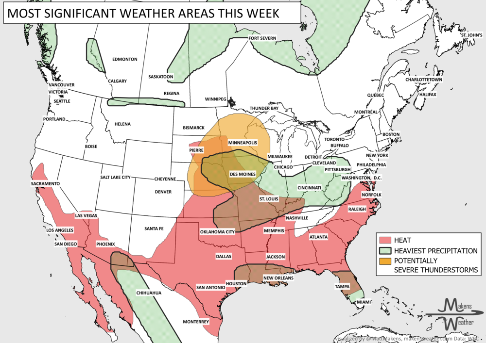
What to watch:
Tuesday, September 8: Hurricane Lowell passes west of Kauai, with heavy rain and high surf possible across the Hawaiian Islands. A Hurricane Warning remains in effect for Kauai and Niihau. On the mainland, strong thunderstorms and locally heavy rain move from the central Plains into Iowa and the Upper Midwest. Dangerous heat continues across the central and southern Plains and mid-Mississippi Valley. Isolated heavy rainfall for southern Alberta and Saskatchewan.
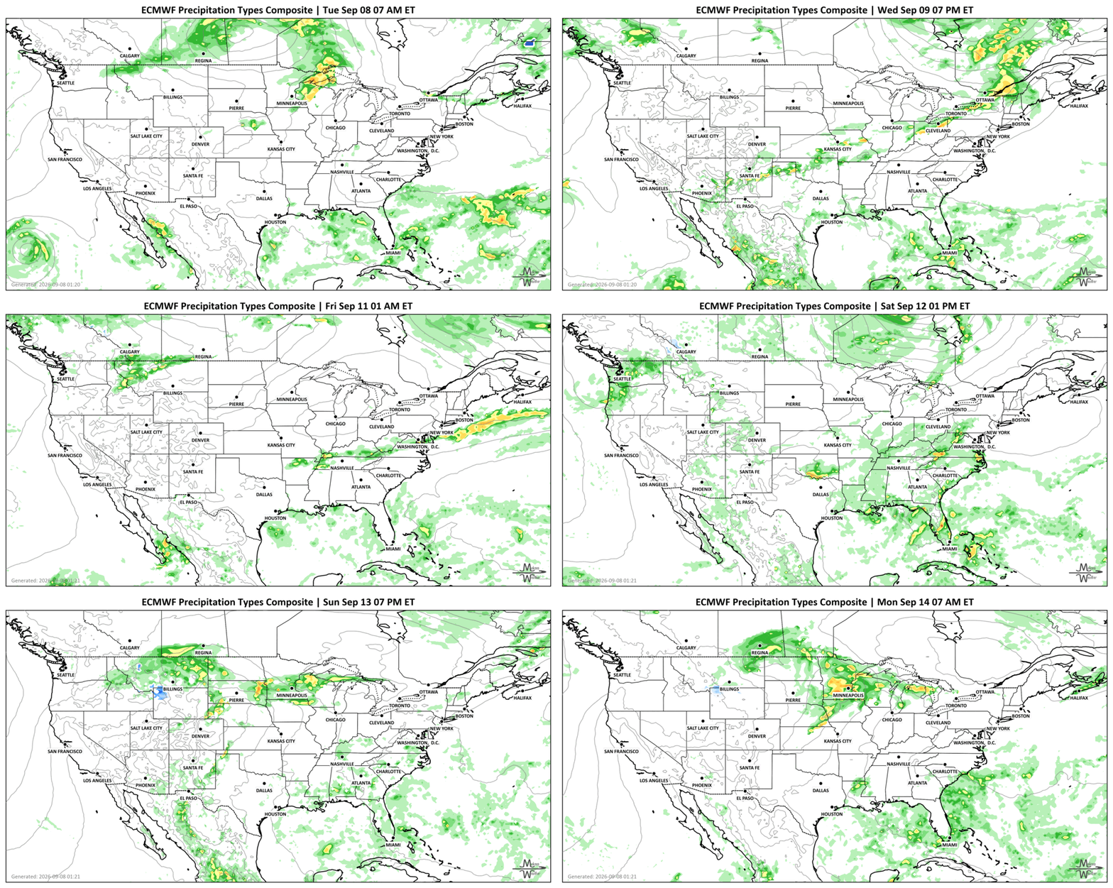
Wednesday, September 9: Rain and thunderstorms stretch from the central Plains through the Midwest and Ohio Valley, eventually reaching interior New England Wednesday night. Locally heavy rainfall becomes a concern around central Missouri and nearby areas. Meanwhile, the South-Central U.S. remains very hot before some relief begins arriving farther north. Heavy rainfall moves from Ontario to Quebec and the Maritimes.
Thursday, September 10: Cooler air starts making more progress through the central U.S., although the heat remains firmly established farther south. Scattered showers and thunderstorms continue across Florida and the eastern Gulf Coast, while monsoonal storms remain possible in Arizona and New Mexico. Snow on the Canadian Rockies.
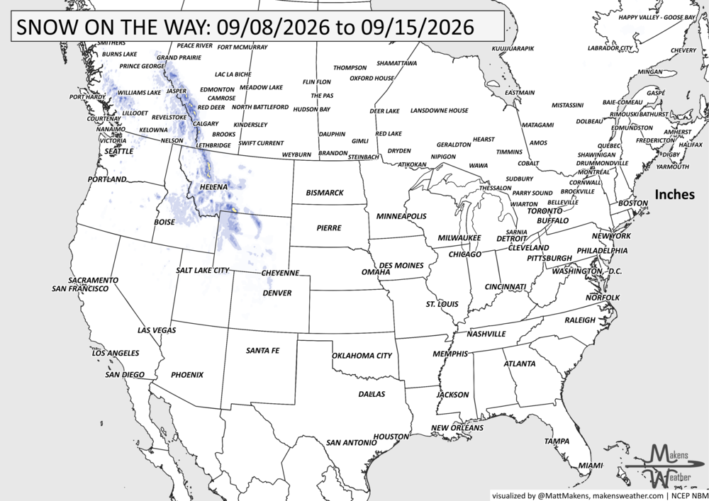
Friday into Saturday, September 11-12: Another front spreads rain from the Midwest toward the Northeast. At the same time, a much cooler system moves into the Pacific Northwest, beginning a notable weather change across the northern tier. Heat continues across the southern Plains and Lower Mississippi Valley. Snow on the peaks from Alberta to Wyoming.
Saturday into Sunday, September 12-13: Cooler air pushes into the northern Rockies, where some high-elevation wintry weather could develop. Rain also becomes more widespread from the Northwest into the northern Plains.
Sunday into Monday, September 13-14: The northern storm system moves east, increasing the potential for moderate to heavy rainfall across the Upper Mississippi Valley, Midwest and Great Lakes. This looks like one of the more important precipitation periods to watch later in the forecast.
Through Tuesday, September 15: The greatest heat threat becomes increasingly concentrated over the southern Plains, while daily monsoonal showers and thunderstorms continue around the Four Corners. Another disturbance approaches the Northwest around Tuesday.
SET YOUR WATCHES - WHEN THE MOISTURE ARRIVES:
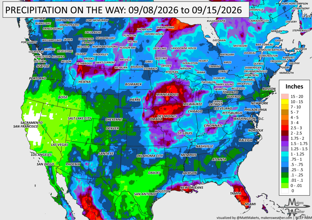
IN THE GAUGES, PRECIPITATION THROUGH THE 15TH:
Note: these projected totals are likely to be over/under-done in many areas because thunderstorms will be the primary source of rainfall, and we know what they can do.
GRAB A RULER, SNOWFALL THROUGH THE 15TH:
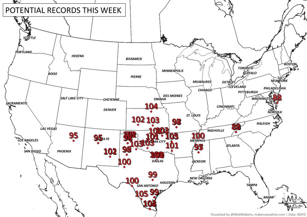
RECORDS MADE TO BE BROKEN, DAILY HIGHS (RED) | DAILY LOWS (BLUE):
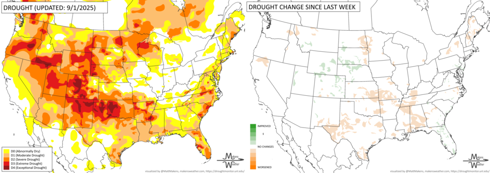
UN-DROUGHTABLY DRY:
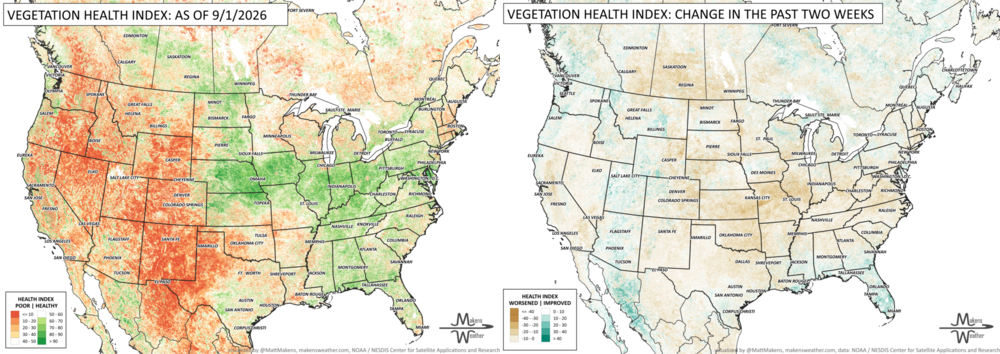
Dry and unusually warm weather is quickly worsening drought across parts of the central U.S., with flash drought developing from Texas and Oklahoma northeast through southern Kansas, Missouri and Arkansas into the lower Mississippi Valley. Agriculture is feeling the effects, and fire danger is increasing in some areas. Conditions also worsened near the Dakotas-Minnesota border and in northern California. On the other hand, recent rainfall brought some improvement from Wyoming and eastern Colorado into Nebraska and southern South Dakota, with localized improvements also reported in parts of the Northeast and Southeast.
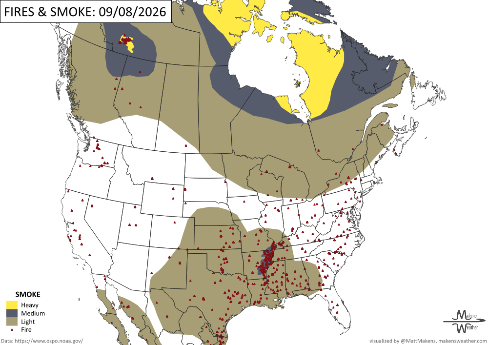
FIRE!
Sunday, 66 new fires were reported nationwide. No new large fires were reported. Firefighters are currently working to contain 65 large fires, with 15,855 firefighters and support personnel assigned to incidents nationwide. In 2026 so far, there have been 53,233 fires reported nationwide, for a total of more than 8.3 million acres. Firefighters are currently engaged on fires in eight geographic areas. -NIFC
TRACKING THE TROPICS
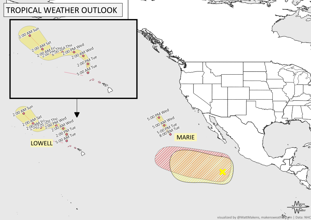
Hurricane Lowell continues to impact Hawaii, with hurricane conditions and widespread power outages possible across Kauai County for the next few hours. Oahu can expect tropical storm conditions and strong wind gusts capable of bringing down trees and causing power outages. Heavy rain will continue across the Hawaiian Islands through Wednesday, raising the risk of flash flooding and mudslides, especially on Kauai and portions of the Big Island. Large waves will also maintain dangerous surf and rip currents along exposed coastlines through the next day or so. -NHC
ARE YOU CIRRUS?!
In weather history:
1900: The deadly Galveston Hurricane made landfall in Texas as a Category 4 storm. A storm surge of more than 15 feet overwhelmed Galveston Island, killing an estimated 6,000 to 12,000 people. It remains the deadliest Atlantic hurricane in U.S. history.
1925: An exceptional drought and heat wave gripped South Carolina. Calhoun Falls reached 111°F on this date and recorded 11 days above 100°F during September.
1998: A severe thunderstorm swept through the Las Vegas Valley, producing damaging winds and heavy rain. Henderson Executive Airport recorded an 80 mph gust, while winds estimated at 80 to 90 mph severely damaged about 15 homes and trailers in Moapa.
2012: Severe thunderstorms struck the New York City area, delaying play at the U.S. Open. Two tornadoes were reported in the city, including one at a beach club in Queens and another that caused damage in Canarsie, Brooklyn.
The weather pattern is about to make a pretty sharp turn across the country. California starts the week with unusual October heat, including highs well into the 90s and even lower 100s in the Central Valley. Meanwhile, much cooler fall air has reached the Great Lakes and Northeast. The Gulf Coast and Southeast stay unsettled, and there’s that record to watch: a tropical depression is likely to develop over the Gulf this week and could strengthen as it moves northeast. If it becomes a hurricane after the 8th, 2026 will have the latest-first hurricane in the Atlantic Basin record.