Discussion and Timeline: Texas Hill Country Catastrophic Flooding (July 2–4, 2025)
What Created This Catastrophic Flood?
The devastating flash flooding that unfolded across Texas Hill Country on July 4, 2025, was the result of a worst-case scenario of atmospheric dynamics, topographic vulnerabilities, and human limitations in preparedness. The disaster wasn't a surprise in concept—the region is one of the most flash flood-prone areas in the nation—but the scale, speed, and sheer volume of rainfall overwhelmed even seasoned emergency managers.
A Meteorological Convergence
At the heart of the disaster was a highly unusual confluence of weather systems that intensified rainfall far beyond normal expectations. Several key features contributed:
Remnants of Tropical Storm Barry drifted north from the Bay of Campeche, carrying latent tropical moisture into central Texas.
That moisture became entrenched in a mid-level trough over the Southern Plains, which slowed movement and allowed storms to “park” over the Hill Country.
A mesoscale convective vortex (MCV) formed—a compact, rotating system that helped focus lift and moisture, producing highly efficient rainfall generation. Think of this as an efficiently firing engine.
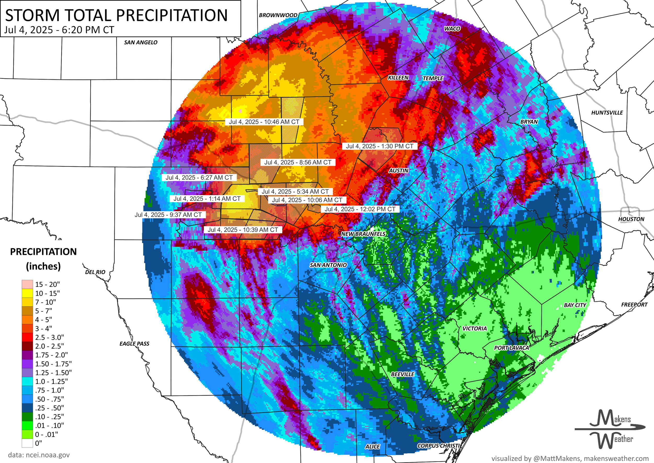
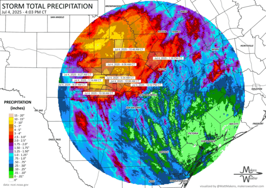
Rainfall rates reached 2 to 4 inches per hour, with total accumulations up to 18–20 inches in localized areas like Kerr and Mason Counties.
These elements together produced “extraordinary” precipitable water values—essentially, the atmosphere was primed to squeeze out as much rain as physically possible over a short time.
Texas Hill Country—often called Flash Flood Alley—features a dangerous mix of:
Steep, rugged terrain that funnels rainfall downslope rapidly
Clay-rich soils that don’t absorb water well, increasing runoff
Narrow floodplains that concentrate water into rivers and low-lying communities
When the storms unleashed torrents of rain, the Guadalupe River surged over 26 feet in just 45 minutes, marking the second-highest crest on record. In some areas, that wave of water moved like a wall, sweeping away cabins, campers, vehicles, and entire neighborhoods before sunrise.
Additionally, severe to exceptional drought conditions had gripped Kerr County for months before the storm. Dried-out soils initially repelled the rainfall, worsening runoff and accelerating water accumulation.
🟠 Wednesday, July 2, 2025
All day — TDEM activates state emergency response resources ahead of the holiday weekend due to flood threats (All sources).
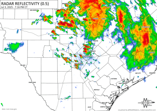
Afternoon — NWS Austin/San Antonio begins flagging moderate to heavy showers in Hill Country (NPR).
Camp Mystic passes emergency plan inspection (AP).
🟡 Thursday, July 3, 2025
6:36 a.m. — NWS issues short-term guidance highlighting “very tropical” atmospheric conditions (CNN).
7:38 a.m. — WPC warns of "training" storms over Hill Country (USA TODAY).
10:00 a.m.
TDEM hosts briefing for city/county officials; some confirm contact, others (like Kerrville’s mayor) do not recall being notified (AP, CNN).
Zoom meeting held with meteorologists and officials; unclear if Kerr County attended (USA TODAY).
12:17 p.m. — NWS warns storms are intensifying over S Central Texas (USA TODAY).
1:18–1:24 p.m. — Flood Watch issued for Kerr County, 5–7” possible (NPR, USA TODAY, AP).
3:39 p.m. — Watch posted publicly on social media (USA TODAY).
6:10 p.m. — WPC notes back-building storms could drop >3”/hr; “locally considerable flash flooding” possible (USA TODAY).
7:45 p.m. — Guadalupe River gauge at Kerrville begins slow rise (USA TODAY).
11:13–11:41 p.m. — Bandera County upgraded from flood advisory to flash flood warning; gauge near Tarpley records 2.68” in 45 minutes (USA TODAY).
🔴 Friday, July 4, 2025 – Overnight Flash Flood Disaster
12:26 a.m. — WPC confirms flash flooding likely overnight; 2–3”/hr rainfall rates expected (USA TODAY).
12:56 a.m. — Storms merge over central Kerr County; Kerrville River gauge rising (USA TODAY).
1:14 a.m. — Flash Flood Warning issued for Kerr County (NPR, AP).
1:20–1:30 a.m. — Guadalupe River gauges at Hunt and Bear Creek begin sharp rise; water level at Kerrville creeps up to 0.84 ft (USA TODAY).
1:48–2:28 a.m. — Radar shows 2–5” already fallen in southern Kerr County (USA TODAY).
2:00–2:30 a.m. — Camp Mystic begins emergency relocation of girls to higher ground (CNN).
3:00–3:30 a.m.
River begins catastrophic rise. Hunt gauge jumps 6.3 ft in 2 hours.
Kerrville City Manager Dalton Rice jogging near the river, sees “light rain” but no sign of danger (CNN, AP).
Floodwaters begin entering homes (e.g., Bumble Bee Hills); people cling to rooftops and trees (AP, CNN).
3:35 a.m.
NWS extends flash flood warning to 7:00 a.m. based on radar/gauges (AP).
Hunt gauge at 16 ft (flood stage = 10 ft).
4:00 a.m.
First police rescues and reports of dozens on rooftops begin (AP).
Flash Flood Emergency declared for Kerr County (NWS, all sources).
4:16–4:35 a.m.
Residents like Jane Towler call 911 while standing on countertops or roofs (AP).
Gauge near Hunt stops transmitting at 29.5 ft — 19.5 ft over flood stage (AP).
5:00 a.m.
Peak surge reaches Kerrville.
Kerrville PD, Sheriff begin Facebook alerts and rescues (NPR, USA TODAY).
5:16 a.m. — Kerrville PD: “Move to higher ground now” (NPR).
5:34 a.m. — Flash Flood Emergency extended to Hunt → Center Point; gauges show “large and deadly flood wave” (AP, USA TODAY).
5:36–5:43 a.m. — Rooftop rescues in Hunt; initial death toll confirmed (USA TODAY, AP).
6:06–6:32 a.m.
Flood warning extended to 10 a.m.
Sheriff confirms rescues, widespread damage (AP).
6:45 a.m.
Guadalupe at Kerrville peaks at 34.29 ft (3rd highest on record) (USA TODAY, AP).
7:17 a.m. — Flash Flood Emergency extends further downstream to Comfort (USA TODAY).
7:32 a.m. — Mandatory evacuations ordered in Comfort (Kendall County EMA, AP).
9:34 a.m. — Rescue boats evacuate families from Carolyn Rd., Comfort (AP).
10:31–10:56 a.m.
Flood sirens activated in Comfort.
Evacuations begin at Guadalupe River State Park (AP).
11:29 a.m.
Camp Mystic contacts parents: “Catastrophic flooding, no power/water/internet” (AP).
11:30 a.m.
Kerr County Judge Kelly: “We do not have a warning system.” Says flood was not expected (AP).
3:30 p.m.
Patrick & Sheriff Leitha provide first confirmed death tolls: 6–13 dead, 23 girls from Camp Mystic still missing (AP, USA TODAY).
7:11 p.m. — Texas Game Wardens evacuate remaining Camp Mystic campers (AP).
9:00 p.m. — Gov. Abbott signs disaster declaration; death toll at least 24 confirmed (AP).