
Understanding El Niño and What a “Super” Event Could Mean
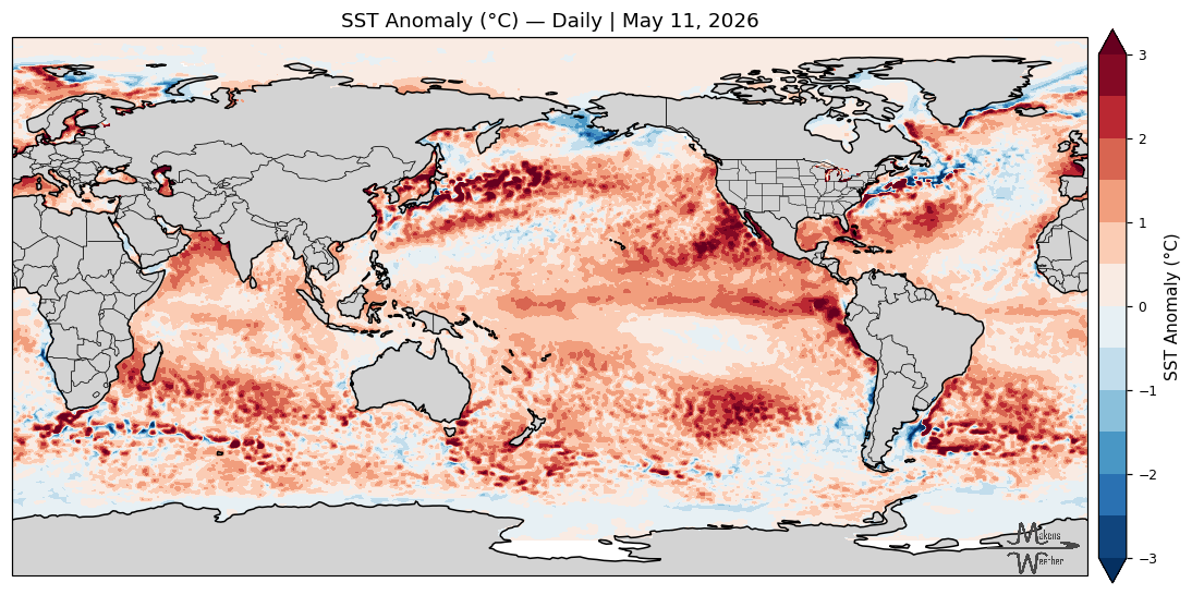
It is no longer gossip or rumor; La Niña has ended, and El Niño conditions have developed. El Niño is one of the most influential climate drivers for global agriculture. Defined technically as the warm phase of the El Niño–Southern Oscillation (ENSO), it occurs when ocean temperatures in the central and eastern equatorial Pacific are above normal, causing the atmosphere to respond and altering weather patterns globally. That ocean–atmosphere “coupling” is what ultimately shifts rainfall, temperature, and storm tracks across key growing regions worldwide. Members may continue to the seasonal precipitation and temperatures outlooks for the rest of 2026 by clicking here.
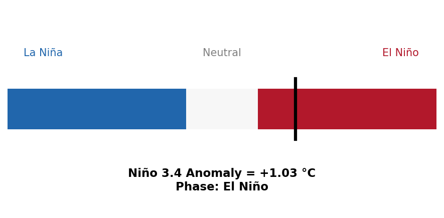
The ENSO conditions as of May 13th (updated daily in the ENSO/SST section of the dashboard):
During the past two winters, the global pattern was in the cool phase of ENSO, La Niña. You may recall me stating something called ENSO-Neutral, too. That is when sea surface temperatures in the central Pacific are near average.
La Niña is our classic troublemaker, bringing widespread drought. ENSO-Neutral has fewer extremes. El Niño typically raises optimism because it can deliver abundant moisture.
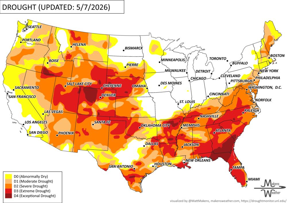
Drought situation as of this posting (the drought and vegetation health products are available here):
From a technical standpoint, El Niño is declared when sea surface temperatures in the Niño 3.4 region reach at least +0.5°C above normal for multiple overlapping three-month periods. Keep in mind, local impacts can be delayed by weeks to months after El Niño thresholds are met in ocean temperatures. But the strength of the event matters far more than the definition itself. Here is a traditional breakdown:
Weak El Niño: +0.5°C to +1.0°C
Moderate: +1.0°C to +1.5°C
Strong: +1.5°C to +2.0°C
Very Strong/Historically Strong/”Super”: warmer than +2.0°C
This is where the concept of a “Super El Niño” comes into play. Although not an official classification used by the National Oceanic and Atmospheric Administration (NOAA), the term is widely adopted in scientific and meteorological communities to describe the strongest events on record, generally those with sea surface temperature anomalies exceeding +2.0°C. These extreme events, such as those observed in 1982–83, 1997–98, and 2015–16, are associated with far more pronounced and disruptive global weather patterns.
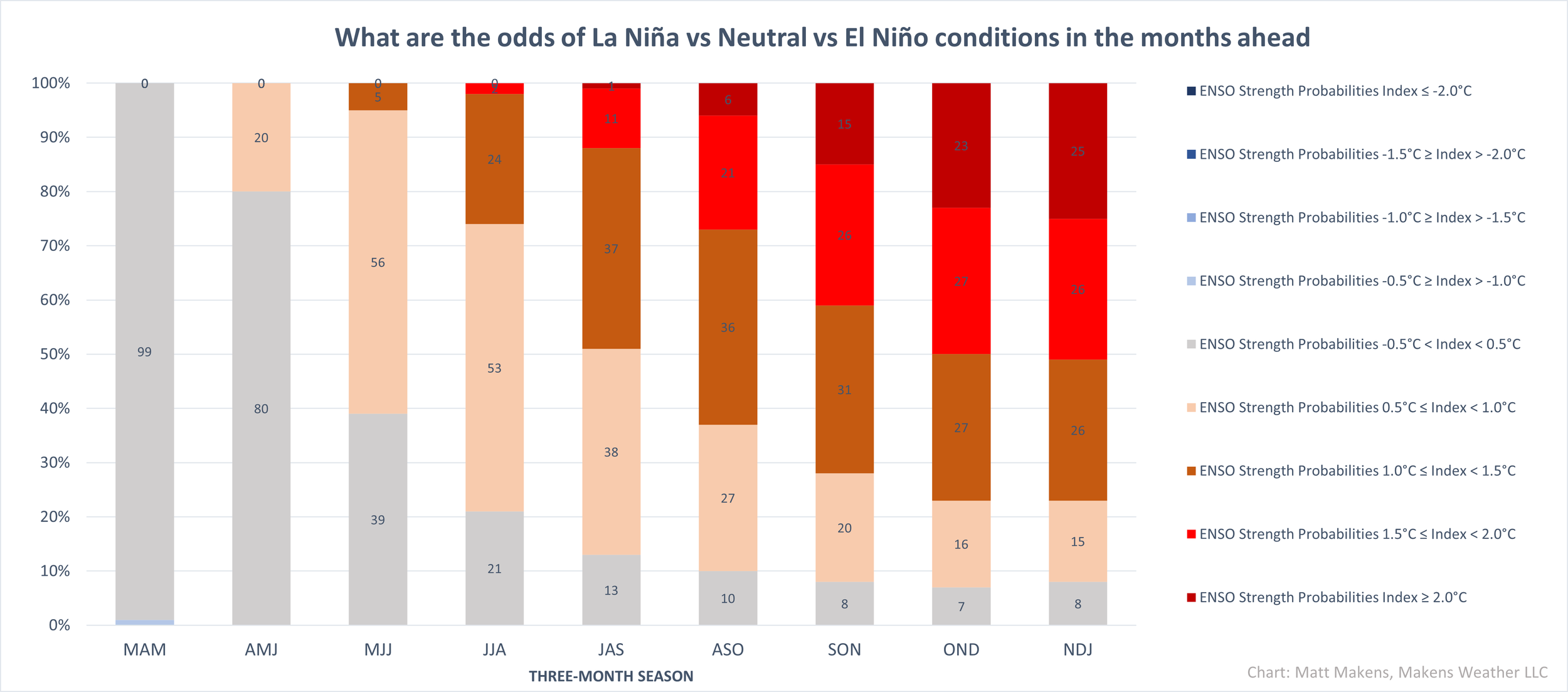
Data collected through mid-May indicate a “super” event is possible, based on historical analogs, current precipitation and wind patterns, and computer simulations. Those computer models have biases; I constantly correct for them for being too warm/cold, fast/slow, etc., and also consider each model's track record. Even so, raw versus bias-corrected data indicate that a moderate or strong event is likely, and a fair percentage (~25%) of the data support a “super” event.
During a typical El Niño, the southern United States tends to experience wetter conditions, while regions such as Australia and Indonesia often turn drier. A “Super” event amplifies these patterns, increasing the likelihood of flooding, drought, and temperature extremes across key agricultural regions worldwide. My research has shown that these stronger events also tend to elevate global temperatures and intensify shifts in the jet stream, further influencing storm tracks and seasonal climate behavior.
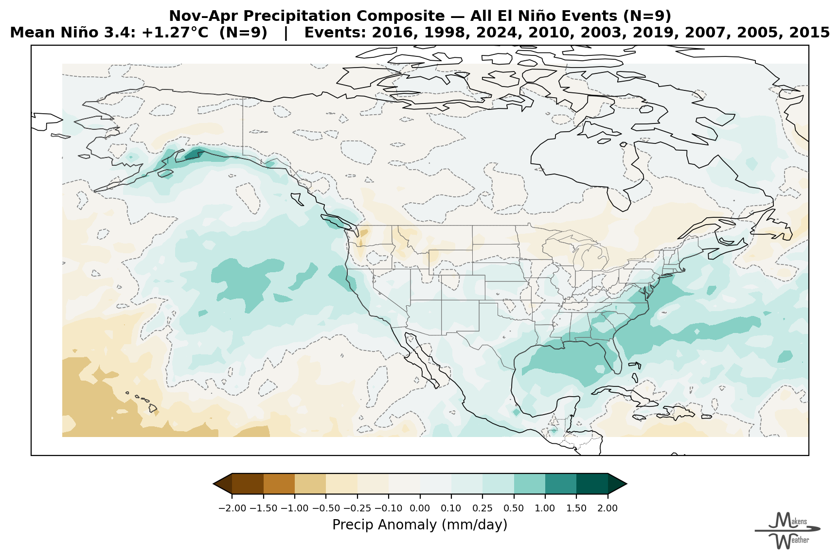
What It Typically Means for North American Agriculture
I almost hate to do this because no two events are the same, with a wide variety of outcomes. Still, if we clump them together to form a “standard El Niño pattern”:
Southern U.S. (Texas to the Southeast): Wetter conditions increase soil moisture and winter wheat prospects, but also raise risks of flooding, disease pressure, and delayed fieldwork.
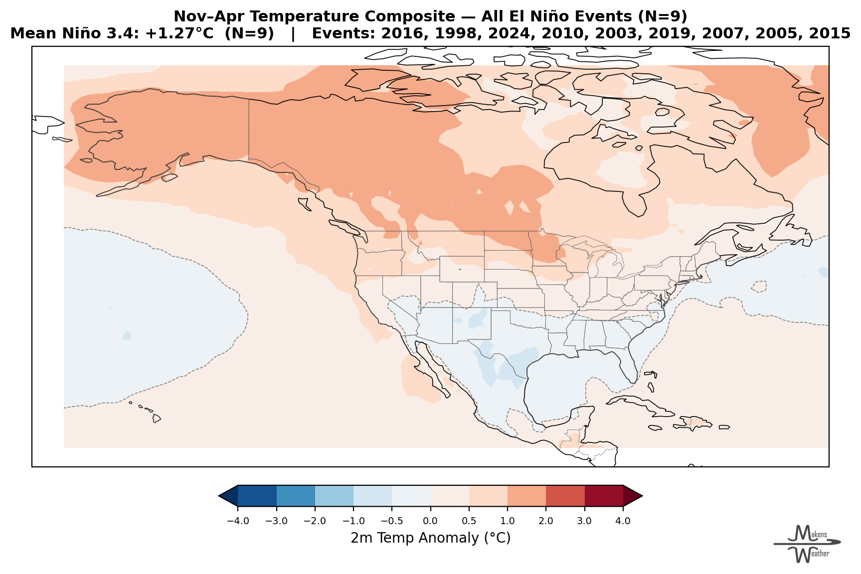
Northern Plains & Upper Midwest: Often warmer and drier during winter, which can reduce snowpack and early-season moisture recharge heading into spring grazing and planting.
Western U.S.: Increased precipitation, particularly across California, can improve reservoir levels and irrigation outlooks, but extreme events can lead to runoff losses rather than usable water storage.
Western Canada typically sees less snowfall and isolated precipitation.
Eastern Canada has a low correlation to ENSO impacts - local impact here will vary year to year based on other global climate drivers.
Canada, in total, typically has warmer winters, as does the Northern U.S.
To illustrate that the composite/mean of all El Niños can be misleading, note the maps for individual events versus the averages shown above... Members may continue to the seasonal precipitation and temperatures outlooks for the rest of 2026 by clicking here.