
Winter 2026-27 Outlook: El Niño and the Drought
Winter 2026-27 Outlook: El Niño and the Drought
Key Takeaways:
A powerful El Niño is reshaping the winter 2026-27 jet stream, bringing much-needed moisture to the South and Southwest.
Despite "Super El Niño" headlines, offsetting Pacific factors (like the PDO) mean moisture won't hit the Central Plains equally.
While short-term forage and wheat establishment will benefit, multi-year groundwater and reservoir deficits will take more than one season to recover.
November 2026 – Matt Makens | Professional Meteorologist & Agricultural Climatologist
After years of drought growth across much of the country, there are recent signs of reversing that trend. One of the strongest El Niño events on record has developed in the Pacific Ocean, and it will bring much-needed moisture to some of the nation's driest areas this winter and spring.
But there is a catch. The drought we are dealing with is widespread, and in some places has been building for years. We are dealing with substantial moisture deficits, so even a very wet winter might not be enough to erase drought from the southern or western U.S.
Still, this gives an opportunity to many producers hoping for better forage overwintering and spring growth conditions. Members have access to their 6-month seasonal forecast in the members’ area.
Why El Niño Matters for Winter Weather
El Niño, technically defined as the warm phase of the El Niño–Southern Oscillation (ENSO), occurs when ocean temperatures in the central and eastern equatorial Pacific are warmer than normal, causing the atmosphere to react and shift climate patterns globally. The strength of an event is scored by how much warmer than normal that area of ocean is, which gives a bigger "shock" to the atmosphere.
When it sets up, it reshapes both the jet stream and storm track across North America. Typically, El Niño strengthens the southern storm track. This is how El Niño impacts winter weather, it favors wetter conditions from California and the Southwest through Texas, Oklahoma, and parts of the Southeast. Meanwhile, the northern United States often experiences a warmer winter with infrequent moisture.
How the 2026-27 El Niño Event Developed
During the past two winters, the global pattern was in the cool phase of ENSO: La Niña. La Niña is our classic troublemaker for the U.S. beef industry, bringing widespread drought.
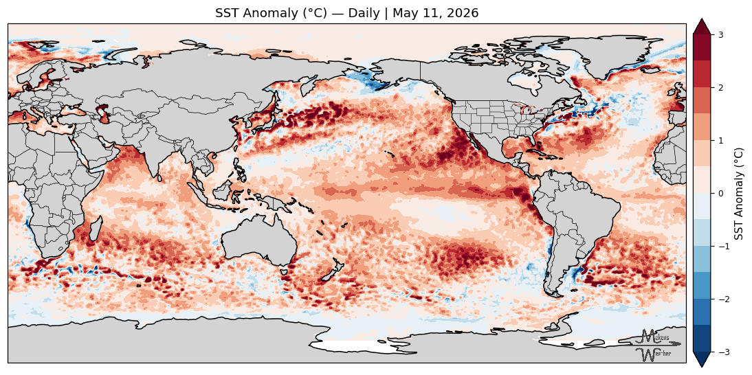
This event developed unusually quickly. In the central Pacific measure I use, the monthly anomaly rose from near average in March to +2.84°C in September - an increase of about 2.8°C over six months. For comparison, the same March-to-September change was about 2.2°C in 1997. Measured from last winter's La Niña low point, the total swing is about 3.5°C. This warm-up causes a “shock” to the atmosphere.
The heat below the surface (the "fuel tank" through the ocean depths) is even more remarkable. The September upper-300-meter temperature anomaly reached +3.39°C, above the previous monthly high of +2.56°C in October 1997 across the 48-year record. This exceptional subsurface warmth fuels El Niño conditions through winter.
An El Niño only matters for weather if it couples with the atmosphere, and in September it clearly did, with pressure, wind, and rainfall over the tropical Pacific at record or near-record readings.
Super El Niño Headlines vs. Meteorological Reality
You have probably seen the headlines: a "Super El Niño" is building in the Pacific, and comparisons to past events are flying. 1982-83, 1997-98, and 2015-16 are the three strongest El Niños recorded in the modern era. 1997-98 is the event a lot of Southwest producers may still remember by name; it broke droughts, filled reservoirs, and produced one of the most dramatic single-season rainfall responses the region has seen.
Is this one the strongest? Depending on the index, yes. The conventional July to September Niño-3.4 three-month anomaly is +2.16°C, the highest value in that record. NOAA's Relative Oceanic Niño Index (newly adopted this year), which adjusts for ocean-wide warming, is +1.69°C for the same season, second to 1997. The gap between the two reflects today's warmer ocean background, which is why some describe the event as record-setting by some measures rather than unanimously the strongest on record.
But here is what those headlines usually skip: no two El Niños are the same event…ever. A stronger El Niño does not automatically mean more moisture – there are offsetting factors that can alter even the strongest of patterns. The 2023-2024 El Niño is a reminder that even strong events do not guarantee rainfall.
The biggest of those offsetting factors is a slower-moving pattern of North Pacific Ocean temperatures, the PDO. When that background pattern is "warm" (positive), it tends to amplify El Niño. When it is "cool" (negative), it acts more like a brake. In every one of the three strongest El Niños on record, that factor tilted in El Niño's favor. This year, it is in its negative phase, which may offset the typical El Niño pattern, especially across the Central and Southern Plains - meaning, not as wet as expected.
Another factor: the entire ocean system is much warmer today than during any of the other strongest El Niños. That can increase the water vapor available to stream into the U.S., so do not read this as saying winter will be a bust because it is not like '97 or '15.
El Niño changes the odds. It does not guarantee the outcome. Watch the probabilities for moisture in your area, not focus on the "strongest since" label attached to the headline.
Regional U.S. Winter Outlook and Agricultural Impacts
In general, El Niño means a milder-than-normal winter (don't confuse milder for no cold risk at all; El Niño reduces the frequency of cold events but does not eliminate them) across the northern two-thirds of the country and a wetter storm track across the southern two-thirds, leaving less frequent moisture across the Northern Rockies and Upper Midwest. The stronger the event, such as this one, the more extreme and regionalized those anomalies can become.
The Southern Plains are one of the key areas to watch and prepare for winter moisture. A wetter winter could improve wheat establishment, forage production, and soil moisture going into spring 2027. The Southwest - Arizona, New Mexico, Colorado, and Utah - carries one of the most consistent wet signals, and the storm track can favor bigger snow events, especially along the Front Range.
Do not assume El Niño moisture will spread equally across the Plains. Kansas, Nebraska, Wyoming, and eastern Colorado sit in a zone where the precipitation relationship becomes less reliable. Farther north, from Montana to the Dakotas, El Niño winters often lean milder and drier. For Northern Plains producers weighing drought risk, El Niño is not the drought-breaking signal it can be farther south.
A final thought: mud. Producers who remember past El Niño events may already be thinking about it. That is the tradeoff. El Niño moisture can improve drought conditions, wheat prospects, and pasture prospects across parts of the southern U.S., but it can also produce periods of difficult cattle weather.
Can one winter undo years of drought?
Through October, more than half of the contiguous United States was in moderate drought or worse. Across Oklahoma and Texas, that number was even higher, at 85% in mid-October. Nationally, drought coverage rivals that of 2012, and improvement will take a long time, just as it did then.
Drought is not simply a matter of how much rain has fallen in recent weeks. There is a big difference between dry topsoil versus a shortage of water that has developed over several years. A few good storms can improve pastures and help crops in the short term, but restoring groundwater, reservoirs, and deeper soil moisture takes a lot longer.
I took a deeper dive into how drought conditions changed during previous El Niño events. Typically, there was improvement across the southern United States, particularly the Southwest and Southern Plains, but the more substantial drought recovery generally took much longer. I took this a step farther and wanted to see what would happen if each region received its highest precipitation recorded from those previous El Niños. Under this theoretical scenario, drought across much of the country could recover significantly, but even if our current event delivered the historical maximum amount of moisture, parts of the West would still be in drought after this El Niño ends. We can have a substantially wet season without solving the water shortage. So, yes, there is some U.S. agricultural drought recovery coming in 2027.
The drought forecast through January favors improvement or removal across much of the South, Southeast, and Southwest. Look for further drought improvement in these areas into March and April before the pattern no longer relies primarily on El Niño. Conversely, drought historically expands in the Northwest, Northern Rockies, Northern Plains, Great Lakes, and Canadian Prairies during winters when the primary storm track is focused across the southern United States.
Looking Ahead: The Risk of a Quick Transition to La Niña in 2027
La Niña is the pattern we have been in six of the last seven winters. Transitioning away from one climate driver's impact to another takes time, but shifting precipitation patterns in the months ahead will ultimately increase precipitation frequency across much of the country, and we begin to bring drought numbers down over time. El Niño typically raises optimism for the industry because it can deliver abundant moisture, improving grazing and forage for most of us. This likely shift is critical.
For producers, the timing matters as much as the total rainfall. Obviously, moisture arriving during winter can help recharge soils, but rainfall extending into spring is particularly valuable for pasture growth and the beginning of the growing season. The opportunity is there. The question is whether, and for how long, the favorable pattern lasts through 2027.
And there is another concern beyond next spring. The 1982-83, 1997-98, and 2015-16 El Niños were all followed by La Niña within a year. La Niña often favors drier conditions across portions of the southern United States. If that transition does indeed come later in 2027, the opportunity for sustained drought recovery could become shorter than many would like. That transition will be critical for cattle herd expansion later in 2027 following the more favorable retention factors early in the year.
For now, the message is that we have a legitimate opportunity to improve drought conditions over the coming months, potentially substantially in some regions. But the longer-term drought problem will not disappear entirely despite headlines calling for a "Super El Niño." The best approach is to take advantage of moisture when it arrives while recognizing that total recovery may take more than one season.
A powerful El Niño is reshaping the winter 2026-27 jet stream, bringing much-needed moisture to the South and Southwest. Despite "Super El Niño" headlines, offsetting Pacific factors (like the PDO) mean moisture won't hit the Central Plains equally. While short-term forage and wheat establishment will benefit, multi-year groundwater and reservoir deficits will take more than one season to recover.