


Weekly Weather Watch: Tuesday, June 17th, 2025
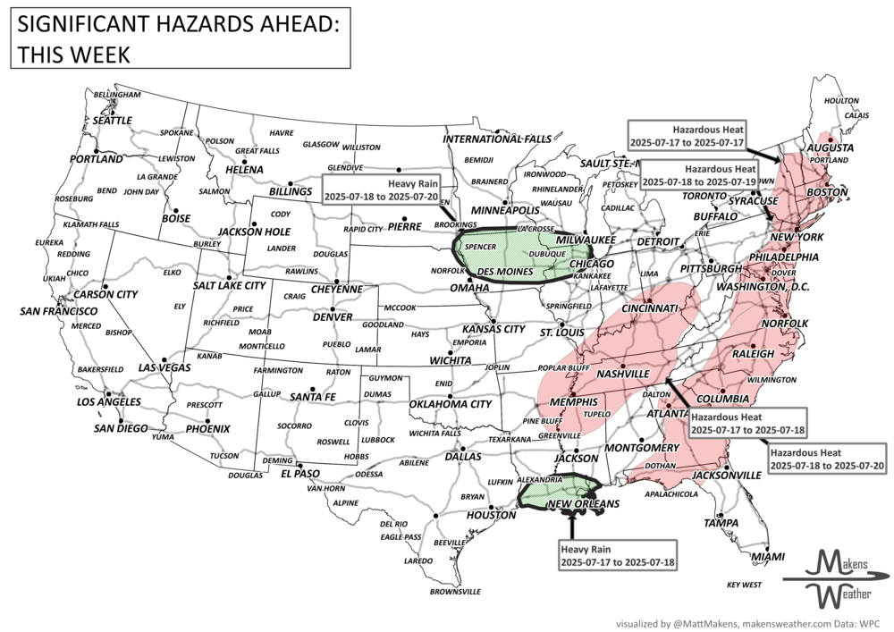
A significant shift in the weather pattern is underway as the season's first major heat wave spreads across the central and eastern U.S. Meanwhile, a series of storm systems will trigger rounds of severe thunderstorms and flash flooding from the Plains to the Midwest and Appalachians. Out West, dry winds and scorching temperatures keep fire weather threats high, particularly in the Southwest. Looking ahead, heat risks only grow stronger as we head toward the end of June. Across Canada, wildfire smoke is the headline for the week, although in the near term severe thunderstorms may impact Quebec.
Members: New dashboards with custom weather information are being developed and will be distributed to you in the coming weeks. Please look for these emails. If you receive heat warnings, your heat indices dashboards are updated through the next 35 days:

HEADLINERS:

🗓️Weather Highlights and Timing:
Tuesday–Wednesday (June 17–18):
Central Plains to Midwest: Severe storms with damaging winds, hail, and isolated tornadoes. Flash flooding possible.
Central Appalachians: Heavy rain may lead to localized flooding.
Southwest (AZ, NM, southern Rockies): Critical fire weather under dry, gusty winds.
Thursday (June 19):
Mid-Atlantic & Eastern U.S.: Rising heat and the potential for severe thunderstorms as a front moves through.
Southern New England: Record highs near 90°F possible.
Friday–Sunday (June 20–22):
Central/Eastern U.S.: First dangerous heat wave of the summer begins—heat indices could top 100–110°F.
Upper Midwest to Great Lakes/Northeast: MCS thunderstorms may bring heavy rain and isolated flooding.
Pacific Northwest to Rockies: Cooler, wetter conditions developing with the next upper-level system.
Next Week (June 24–30):
Ohio Valley, Great Lakes, Northeast, Mid-Atlantic: High risk of extreme heat with limited overnight relief.
Upper Midwest: Potential for heavy rain and severe weather early in the week.
Southern/Central High Plains: Windy and dry—elevated fire weather risk continues.

ON THE RADAR:

KEEP AN EYE TO THE SKY:

IN THE GAUGES:

RECORDS MADE TO BE BROKEN:

ARE YOU CIRRUS?!
1988 Thunderstorms produced large hail and damaging winds across Georgia and the Carolinas. Thunderstorm winds gusted to 75 mph at Eden, NC.
1944 What appears to have been an F5 tornado crossed from South Dakota into Minnesota. Some farms were swept away so completely that there wasn't even any debris left. Eight people were killed.
1882 A tornado traveled more than 200 miles across the state of Iowa killing 130 persons. The tornado traveled at nearly 60 mph and touched down about 90 miles west of Grinnell, struck the town and college around sunset, killing 60, and caused more than half a million dollars damage.
1971 Hurricane Bridget sunk the flagship of the Admiral of the Mexican Navy as it passed off the coast of Mexico near Acapulco.