


Weekly Weather Watch: Monday, September 29th, 2025
As Tropical Storm Imelda stays offshore and intensifies, its moisture and surf will still affect the U.S. coast. Meanwhile, the Pacific Northwest prepares for rounds of rain and snow at higher elevations, while much of the central U.S. continues to experience summery warmth throughout the week. Across Canada, heavy rainfall and mountain snowfall are expected to hit British Columbia, western Alberta, and Ontario.
💧 OCTOBER’S UPDATE
Members, October’s outlook will hit your inbox this Wednesday. In addition, members get full access to the week’s forecast conditions with the interactive dashboard:
📈 Track it 👉 Join Now to Access the Dashboard
HEADLINERS:
Key Weather Impacts:
Monday–Tuesday:
Florida, Georgia, and the Carolinas: Dangerous rip currents and high surf from Imelda and Humberto
Southeast Coast: Scattered tropical downpours with isolated flash flooding, especially in poor drainage areas
Tuesday–Wednesday:
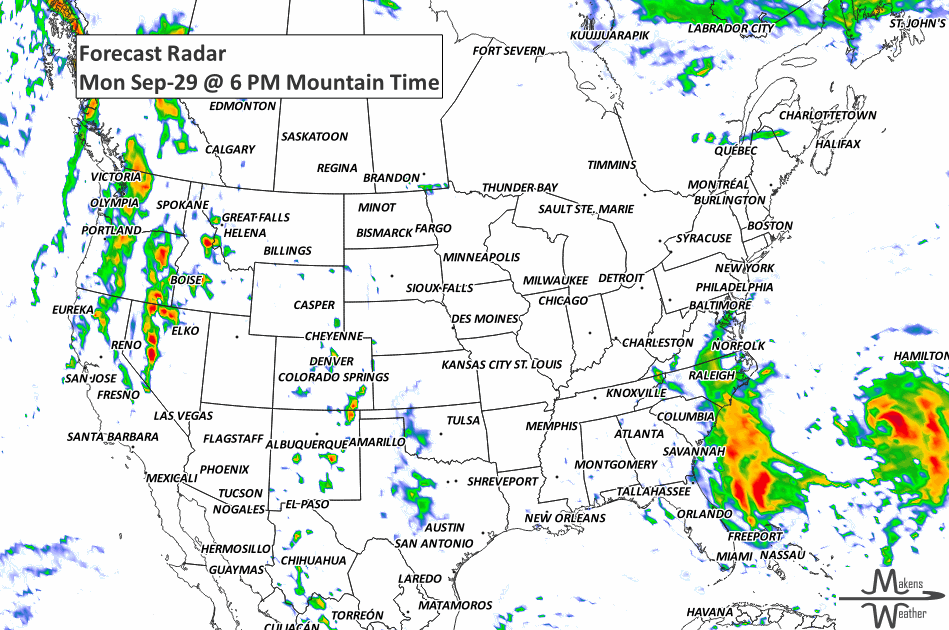
Northern California to the Pacific Northwest: Showers and possible mountain snow from back-to-back Pacific systems
Eastern Oregon, Southern Idaho, Western Montana: Higher rainfall totals possible
Thursday–Saturday:
Gulf Coast and Florida: Rounds of rain and thunder as tropical energy lingers
Rockies and Northern Plains: Cooler, unsettled pattern returns with showers and mountain snow
All Week:
Northern and Central Plains to the Midwest and Great Lakes: Temperatures 10–20° above average, with highs in the 80s and 90s
ON THE RADAR:
KEEP AN EYE TO THE SKY:

IN THE GAUGES:

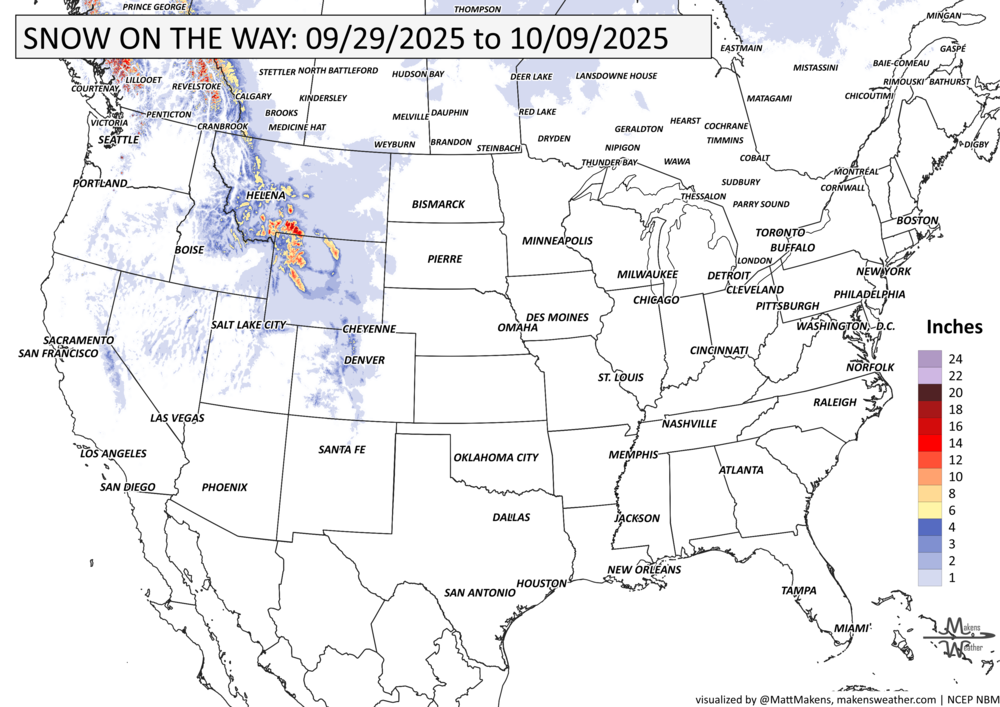
GRAB A RULER:
RECORDS MADE TO BE BROKEN:

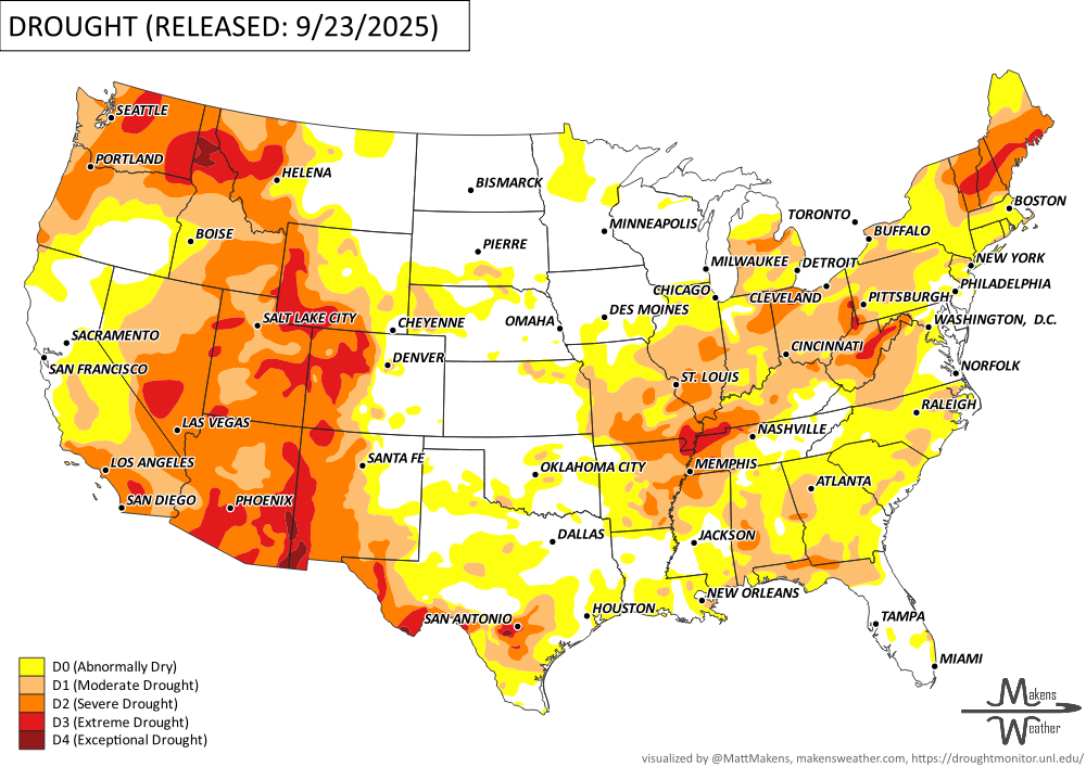
UN-DROUGHTABLY DRY:
This past week brought a mixed bag of drought conditions across the U.S. While some areas saw improvement, others worsened. Rainfall during the monitoring period—especially across the Plains, Midwest, and mid-South—offered some relief. Localized downpours in the Southwest also helped, but in some cases caused flash flooding. Meanwhile, much of the Northwest, Deep South, and Atlantic Coast stayed mostly dry, limiting any improvement in those regions. -U.S. Department of Agriculture
Note: Rain that fell after Tuesday’s cutoff will be reflected in next week’s drought map.
TROPICAL TIDINGS:
The Atlantic remains active with two named storms and several tropical waves being monitored. Here’s what to watch this week:
Hurricane Humberto remains a powerful Category 4 storm, currently well southwest of Bermuda, with peak winds near 130 mph. Humberto is forecast to gradually turn north and then accelerate east-northeast, passing north of Bermuda by midweek. While it stays out to sea, dangerous surf and rip currents will affect Bermuda, the northern Leeward Islands, and much of the U.S. East Coast this week. Life-threatening conditions are possible along beaches—use caution.
Tropical Storm Imelda, located just south of Great Abaco Island in the Bahamas, is slowly moving northward. Imelda is expected to turn sharply to the east-northeast Tuesday, moving away from the Southeast U.S. and could strengthen into a hurricane. Its tropical moisture will continue to enhance rain chances in coastal Florida, Georgia, and the Carolinas, but the greatest threat from Imelda remains in the ocean, with large swells and rip currents along the East Coast.
Three tropical waves are being tracked:
One in the far eastern Atlantic, now west of Africa.
A second in the central Atlantic, producing scattered showers.
A third in the western Caribbean, with limited activity but worth monitoring as it heads west.
No immediate development is expected from the tropical waves, but we’ll keep watch as they progress across the Atlantic basin. -NOAA’s NHC

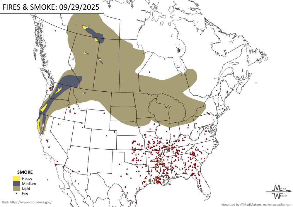
WHERE THERE’S SMOKE, THERE’S …
ARE YOU CIRRUS?!
1896 In 1896, Cedar Key, Florida was a bustling seaport. A major hurricane's ten foot storm surge nearly destroyed the community.
1938 In Charleston, South Carolina, five tornadoes touched down killing 32 people and doing $2 million in damages.
1927 An F3 tornado hit downtown St. Louis and more than 200 city blocks were torn apart. 79 people were killed and 550 were injured.
A soggy pattern stretches across the U.S. this week, with heavy rain and flash flood risks in the Ohio Valley, New Mexico, and possible Nor’easter development near the Mid-Atlantic. Warmth hangs on in the East before a sharp cooldown.