


Weekly Weather Watch: Tuesday, October 7th, 2025
A wave of early fall storminess is on the move this week, with the potential for flash flooding, sharp temperature swings, and the development of coastal storms. A cold front cutting across the Ohio Valley and central Appalachians will spark heavy rain today and tonight, while tropical moisture from Hurricane Priscilla fuels a prolonged stretch of thunderstorms across the Southwest, especially New Mexico and Arizona. Later in the week, attention shifts to the Southeast Coast, where a developing coastal low could bring Nor’easter-like impacts to the Carolinas and Mid-Atlantic. Meanwhile, summer-like warmth continues briefly in the Northeast before the front brings a noticeable cooldown.
💧 OCTOBER’S UPDATE
Members, October’s outlook will hit your inbox last Wednesday. In addition, members get full access to the week’s forecast conditions with the interactive dashboard:
📈 Track it 👉 Join Now to Access the Dashboard
HEADLINERS:
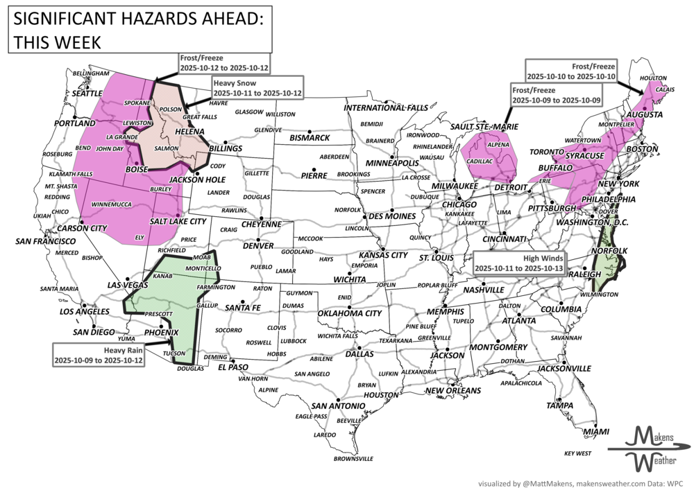
Key Weather Impacts:
Tuesday-Wednesday:
• Heavy rain and flash flooding possible in Kentucky, Ohio, and the central Appalachians.
• New Mexico also faces a flash flood risk from tropical moisture and stalled fronts.
• Warmth lingers in the Northeast, with highs 10–20° above normal.
• Chill sets in behind the front with freeze alerts in the Upper Midwest.Thursday-Friday:
• Cold front clears the East Coast but rain may linger in the Carolinas.
• Tropical Storm Jerry approaches the northern Leeward Islands.
• Tropical moisture begins pushing into the Southwest U.S., increasing flood potential.Weekend (Oct 11–13):
• A potential Nor’easter may form off the Carolinas, drifting toward the Mid-Atlantic, with heavy rain and wind risks.
• Hurricane Priscilla’s moisture fuels flood threats from Arizona to Colorado and New Mexico.
• Possible mountain snow in the West as an upper trough moves through.By Monday-Tuesday (Oct 14):
• The storm train continues in the Southwest U.S. and Intermountain West.
• Temperatures moderate in the central U.S., but cooler air settles along the East Coast.
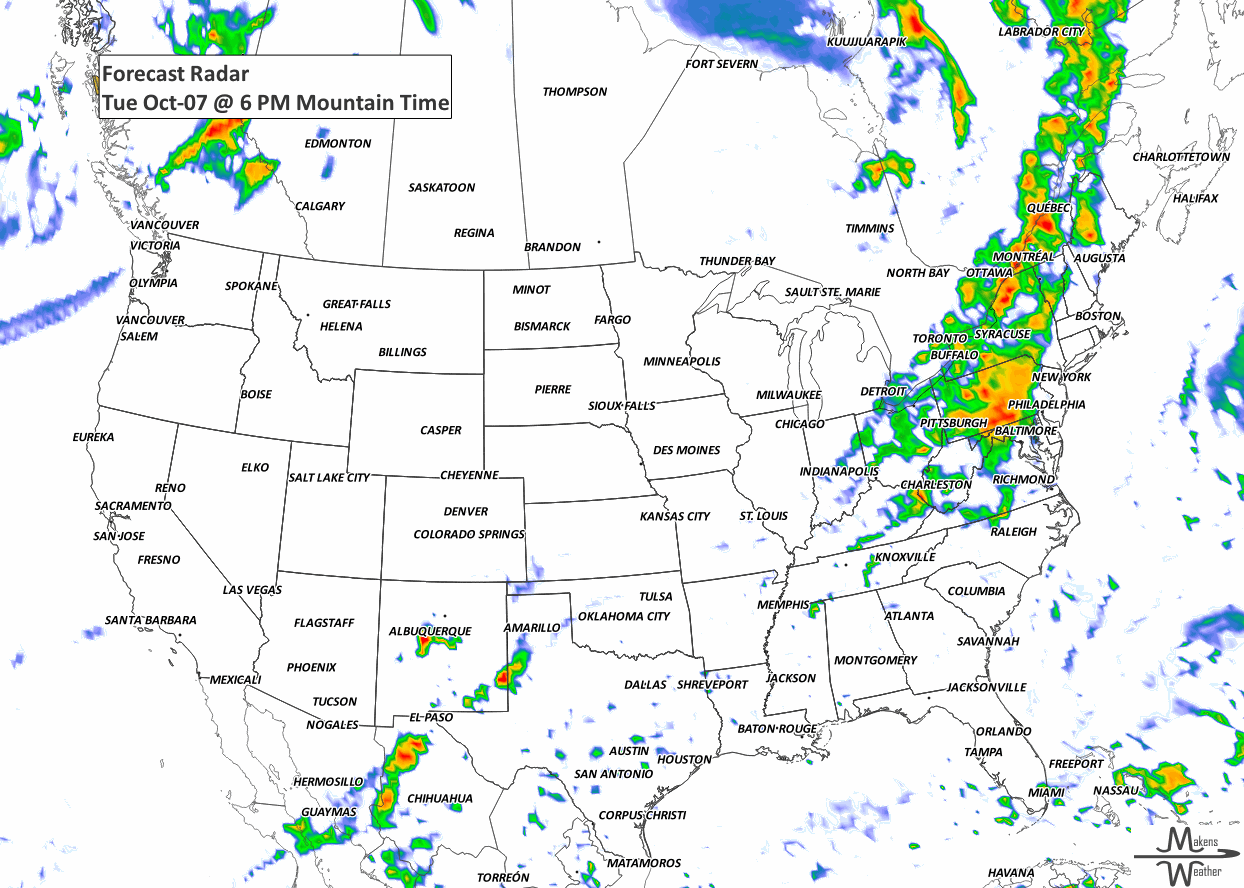
ON THE RADAR:
KEEP AN EYE TO THE SKY:

IN THE GAUGES:
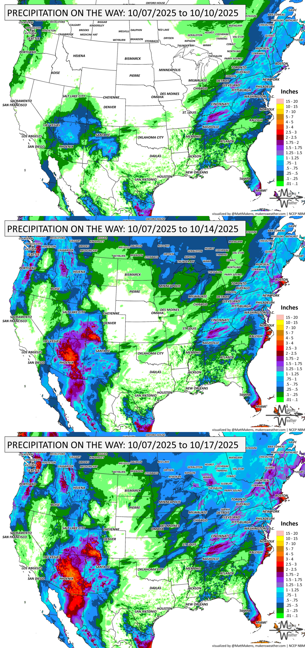
GRAB A RULER:

RECORDS MADE TO BE BROKEN:

UN-DROUGHTABLY DRY:
Widespread rain brought 1–2 inches or more to parts of Arkansas, Tennessee, Kentucky, and into the Northeast, including eastern New York and southern New England—helping to slow or reverse drought trends in some areas. However, southern Missouri, northern Arkansas, and parts of New England saw only limited improvement, as dryness has been deeply entrenched.
Meanwhile, very dry weather continued across the Upper Midwest, northern Great Plains, and Lower Michigan, with some areas slipping further into drought. On the flip side, recent rains helped improve drought conditions in the High Plains, especially in Wyoming, Colorado, New Mexico, and parts of the West.
A flash drought has rapidly emerged across the Southeast, notably impacting southern Georgia’s peanut crop. Most of the country saw above-normal temperatures, with the Upper Midwest, Northeast, and northern Plains baking in late-season heat, up to 10°F above normal. -U.S. Department of Agriculture

TROPICAL TIDINGS:
In the Atlantic, Tropical Storm Jerry—the season’s tenth named storm—is expected to pass near or north of the northern Leeward Islands on Thursday and Friday. While its exact track is still uncertain, this system could bring gusty winds and rain to parts of the northern Caribbean later this week.
Meanwhile in the eastern Pacific, Hurricane Priscilla is intensifying off the west-central coast of Mexico, tracking northward. Though expected to weaken by midweek, its moisture is already beginning to stream into the Desert Southwest, setting up a multi-day risk of flash flooding from New Mexico to Colorado. Additional tropical development is possible off southern Mexico this weekend, where another system could become a tropical depression. Interests from Baja California Sur to the Yucatán Peninsula and the Gulf of Mexico should keep watch, as swells and heavy rain from these systems may impact coastal waters. -NOAA’s NHC

WHERE THERE’S SMOKE, THERE’S …

ARE YOU CIRRUS?!
1844 A major hurricane swept over Jamaica, Cuba and the Bahamas. 158 vessels were wrecked and 2546 houses were destroyed along the Cuban coast.
A drawn-out storm pattern will keep much of the country active through the first week of April. A slow-moving front stretching from the Great Lakes into the Plains will separate late-season snow and ice to the north from heavy rain and severe thunderstorms to the south. The setup brings the greatest impacts to parts of the Midwest, Ohio Valley, Southern Plains, Mississippi Valley, and eventually the East Coast, while the West sees mountain snow and then a warming trend heading into the weekend.