


Weekly Weather Watch: Tuesday, October 28th, 2025
This week kicks off with widespread showers and a few storms pushing across the Mid-South to the Mid-Atlantic, bringing the potential for heavy rain and some localized flooding. Temperatures will trend cooler across much of the central and eastern U.S., while the Pacific Northwest faces another round of rain and high-elevation snow. Meanwhile, a dangerous Category 5 Hurricane Melissa is set to cross Jamaica and Cuba, posing serious hazards in the Caribbean. A vigorous Pacific frontal system will bring damaging winds to northern Vancouver Island, Haida Gwaii, and BC’s Central Coast late Tuesday into early Wednesday. Gusts could reach 110 km/h, with the potential for minor structural damage and scattered power outages.
💧PRF INSURANCE
For those in agriculture, PRF insurance isn’t due until December, but I’m already processing many requests for 2026 rainfall grid outlooks. Members receive discounts on custom PRF grid analyses.
📈 The latest outlooks and conditions - track it 👉 Join Now to Access the Dashboard
HEADLINERS:
Key Weather Impacts:
Tuesday
Rain and gusty winds in the Carolinas and Mid-Atlantic, especially near the Outer Banks.
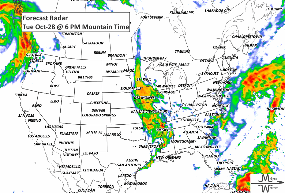
Rain expands across the Mississippi Valley, with possible thunderstorms in the Mid-South.
Wednesday
Widespread rain and storms stretch from the Ohio and Tennessee Valleys into the Appalachians.
Cooler air continues pushing into the Gulf Coast.
Rain/snow mix continues early in the Pacific Northwest, then dries out.
Friday–Saturday
Heavy rain returns to the Pacific Northwest as a moderate atmospheric river pushes in.
The Northeast dries out, with lake effect showers behind a departing system.
Cooler-than-normal temps persist in the East; warmth builds in the West.
Sunday–Tuesday (Nov 2–4)
Warmth surges into the Central U.S. while the East stays chilly.
Another Pacific storm may brush the Northwest Coast late Monday or Tuesday.
Tropics
Hurricane Melissa to make landfall in Jamaica Tuesday, then cross southeastern Cuba Wednesday. Life-threatening storm surge, damaging winds, and flash flooding expected.
ON THE RADAR:
KEEP AN EYE TO THE SKY:
IN THE GAUGES:

GRAB A RULER:

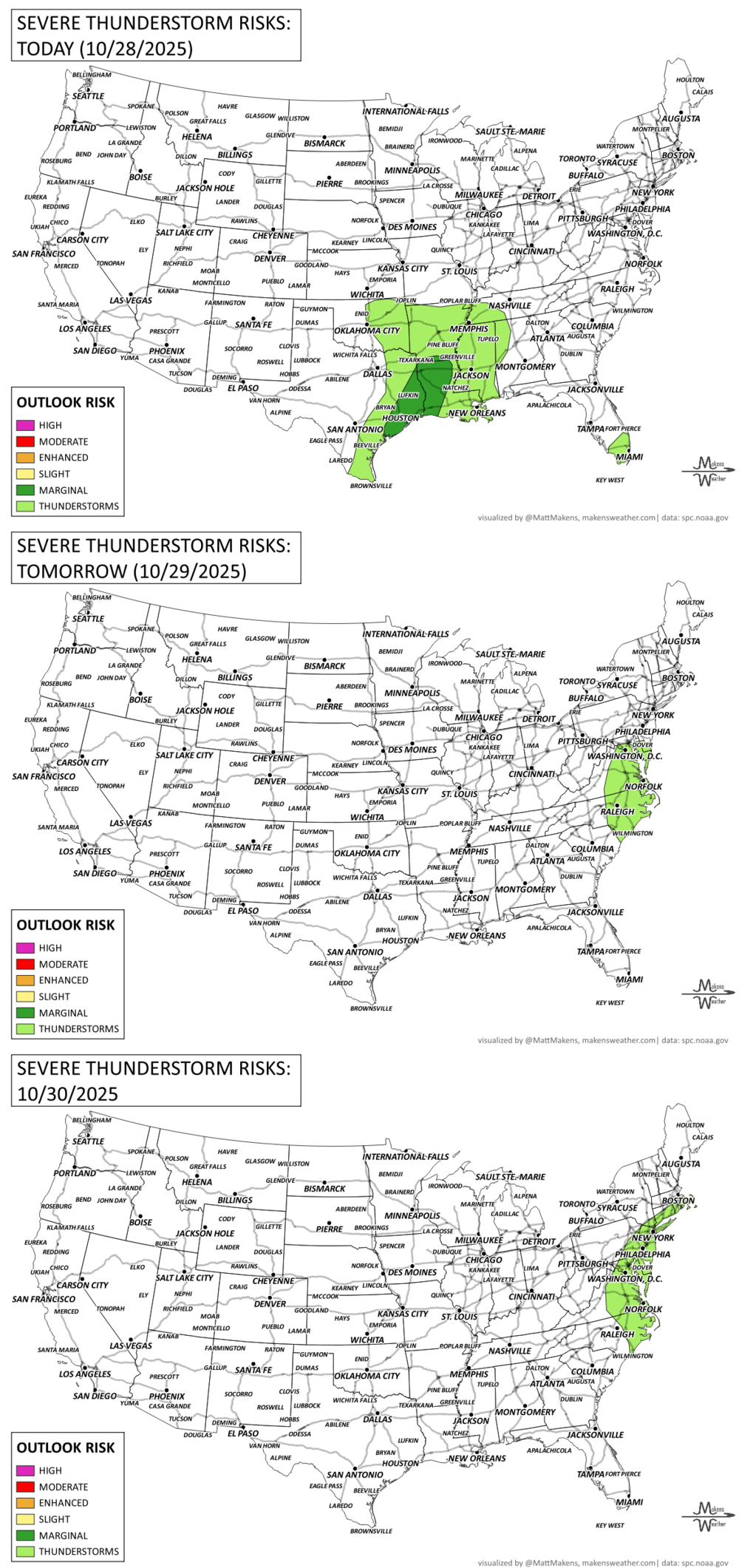
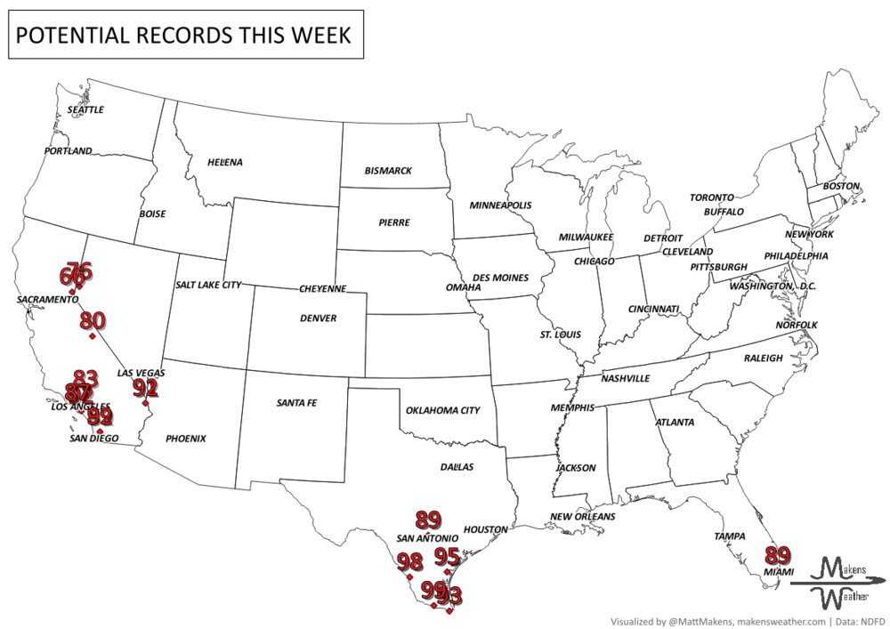
RECORDS MADE TO BE BROKEN:
UN-DROUGHTABLY DRY:
Despite recent rainfall in several regions, drought conditions remain widespread across the U.S.
72% of the Lower 48 remains abnormally dry or in drought, though this is a slight improvement from last week.
Severe Drought (D2 or worse) affects about 21% of the country — down from 23%.
Areas seeing improvement:
Ohio and Mississippi Valleys, interior Northeast, parts of the Rockies, Pacific Northwest, and even sections of California received welcome rainfall.
Areas with worsening conditions:
Southern and Central Plains, South Atlantic states (from Georgia to Virginia), and parts of the Lower Mississippi Valley.
In short: While there's been some local improvement, dry conditions continue to expand in key southern and southeastern areas, keeping drought a major concern heading into November. -U.S. Department of Agriculture

TROPICAL TIDINGS:
Hurricane Melissa is the top tropical threat this week — a powerful and dangerous Category 5 hurricane in the western Caribbean.
Melissa is forecast to make landfall in Jamaica Tuesday, then cross southeastern Cuba Wednesday before moving through the southeastern Bahamas.
Sustained winds near 150 knots (175 mph) make this an extremely dangerous storm capable of catastrophic damage.
Life-threatening storm surge is expected along Jamaica’s southern coast (9–13 ft), with additional surge risks in southeastern Cuba and the Bahamas.
Outer bands are already affecting Nicaragua and surrounding waters, and destructive waves and rip currents will spread throughout the region.
Elsewhere in the tropics:
Tropical Storm Sonia is in the eastern Pacific, well west of Mexico. It's expected to weaken over the next couple of days and does not pose a threat to land.
-NOAA’s NHC

ARE YOU CIRRUS?!
1999 As a newlywed couple was having their pictures taken, the bride was swept away to her death because of tremendous waves from a Pacific storm at Pacific Grove, California.
1971 A severe early season blizzard raged through the plateau and Rocky Mountain region. Heavy snows blocked railroads and interstate highways. Lander, Wyoming was buried under 27 inches of snow and the temperature at Big Piney, Wyoming plunged to 15 degrees below zero.
1998 The crew of 31 aboard the cruise ship Fantome were lost and never found because of Hurricane Mitch's 115 mph winds.
A drawn-out storm pattern will keep much of the country active through the first week of April. A slow-moving front stretching from the Great Lakes into the Plains will separate late-season snow and ice to the north from heavy rain and severe thunderstorms to the south. The setup brings the greatest impacts to parts of the Midwest, Ohio Valley, Southern Plains, Mississippi Valley, and eventually the East Coast, while the West sees mountain snow and then a warming trend heading into the weekend.