




Weekly Weather Watch: Tuesday, October 20th, 2026
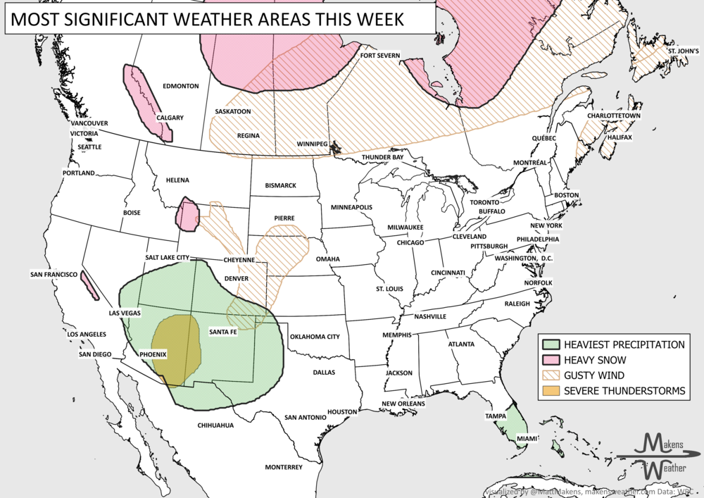
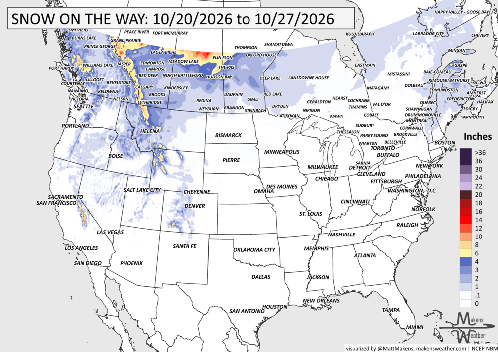
A nor'easter will continue to cause problems along the Mid-Atlantic coast through midweek, with coastal flooding, beach erosion and dangerous marine conditions. Meanwhile, a storm moving into the West will pull unusually high amounts of moisture into the Southwest and Four Corners, increasing the risk of flash flooding Wednesday and Thursday. That storm will eventually spread rain and thunderstorms into the Plains this weekend, with some locally heavy rainfall possible. Snow is also likely in the higher elevations of the Sierra Nevada and Rockies. Temperatures will run cooler than normal across much of the West, while the Central U.S. stays unusually warm for late October. Another Pacific system will bring precipitation into the Northwest this weekend, and parts of Florida could see repeated rounds of heavy rain. An area of potentially heavy snow will move from British Columbia mid-week, toward mountainous Alberta and northern Saskatchewan by later in the week, then onto central and northern parts of Manitoba, Ontario, and Quebec by the weekend.

📈 The latest weekly and monthly outlooks 👉 Join Now to Access
HEADLINERS:
What to watch:
Tuesday–Wednesday: A nor'easter brings coastal flooding, beach erosion and dangerous surf from southern New Jersey to coastal North Carolina. Wind gusts may exceed 40 mph, particularly along the Outer Banks. Heavy snowfall is expected in parts of Quebec and the Maritimes.
Wednesday–Thursday: Heavy rain and thunderstorms develop across Southern California, Arizona, Utah, New Mexico and Colorado. Flash flooding is a concern.
Thursday–Friday: Rain continues across the Southwest and central Rockies, with accumulating snow possible at higher elevations. Rainfall begins moving toward New Mexico, western Texas and the High Plains. Heavy snowfall expected in parts of British Columbia, spreading toward Alberta and Saskatchewan.
Friday–Saturday: Showers and thunderstorms increase across New Mexico, Texas and the central Plains. Heavy snowfall in parts of Alberta and Saskatchewan.
Saturday–Sunday: Another storm brings rain and higher-elevation snow to the Pacific Northwest and northern Intermountain West. Meanwhile, periods of heavy rain could produce localized flooding in southeast Florida. Heavy snowfall spreads from Saskatchewan to Manitoba and then onto Ontario.
Sunday–Tuesday: Rain and thunderstorms may continue spreading across the central and southern Plains as the western storm moves east.
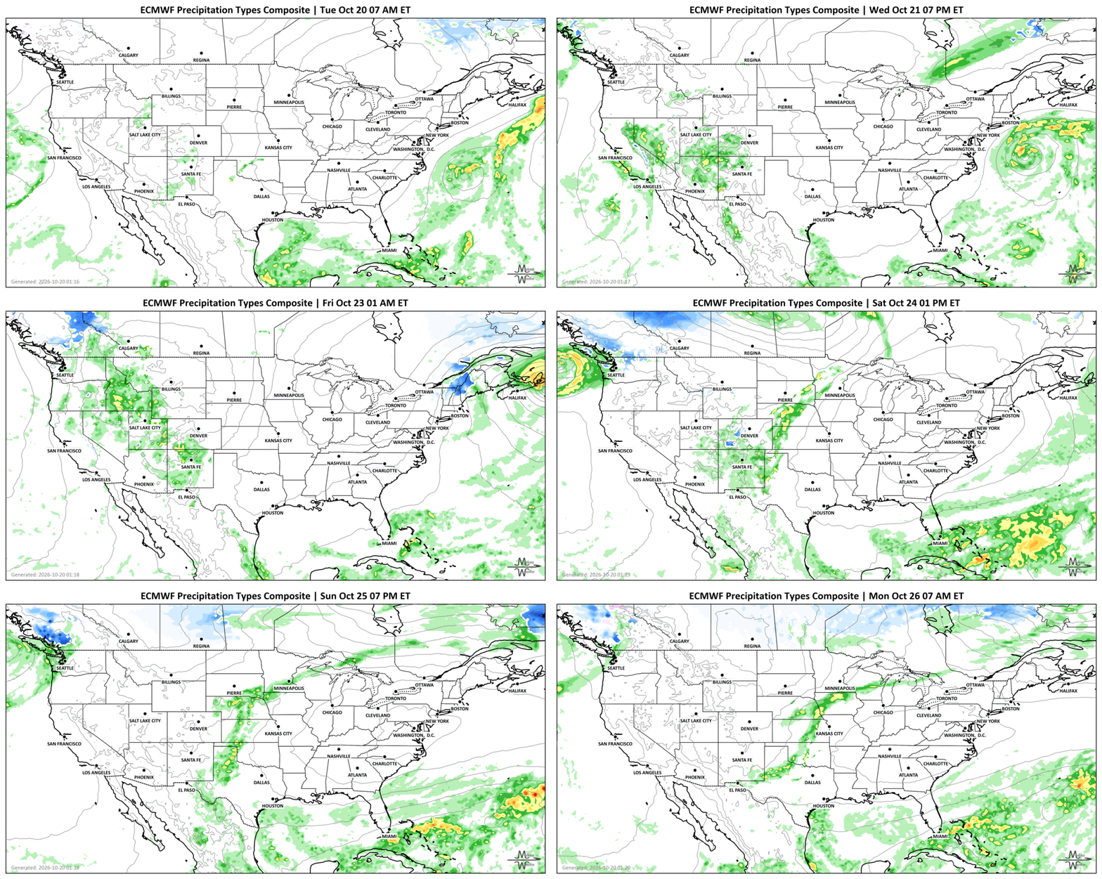
SET YOUR WATCHES - WHEN THE MOISTURE ARRIVES:
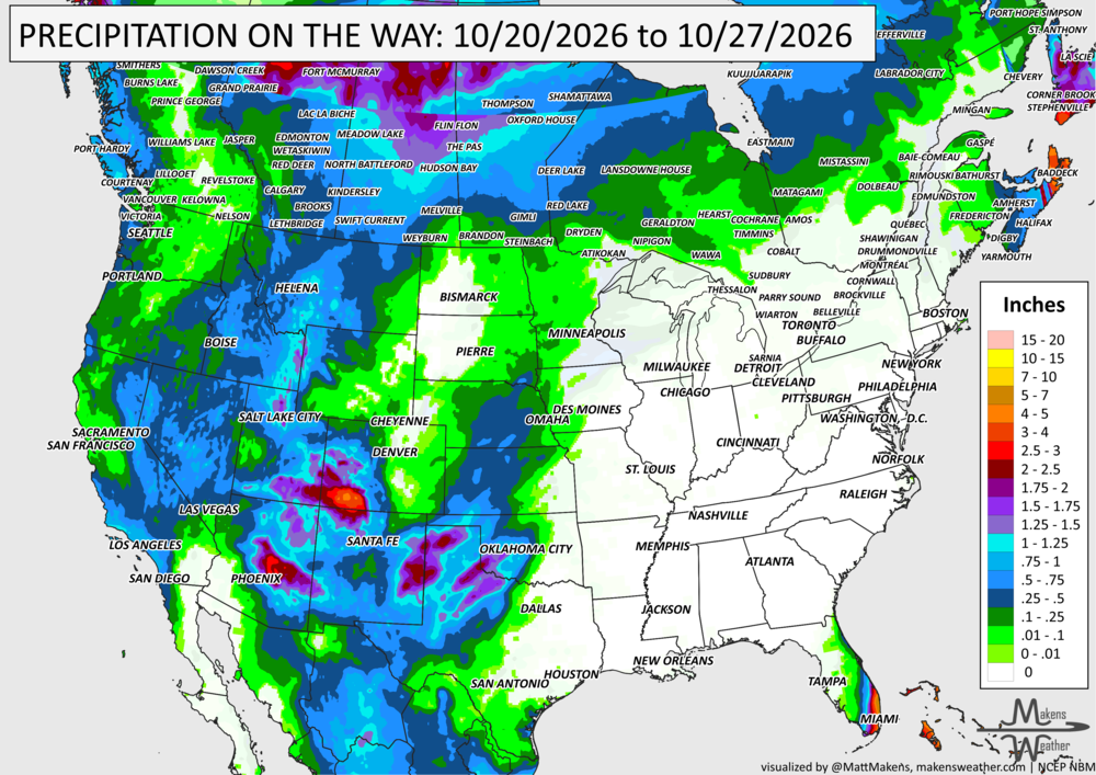
IN THE GAUGES, PRECIPITATION THROUGH THE 27TH:
GRAB A RULER, SNOWFALL THROUGH THE 27TH:
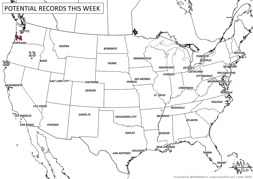
RECORDS MADE TO BE BROKEN, DAILY HIGHS (RED) | DAILY LOWS (BLUE):
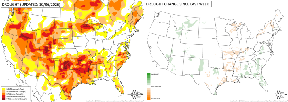
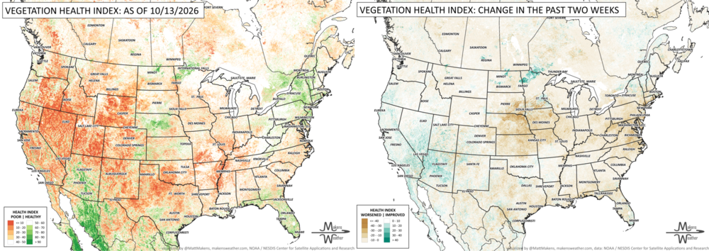
UN-DROUGHTABLY DRY:
Drought conditions varied considerably across the country this week. Rain and early-season snow brought some relief to the West and Southwest, including parts of Arizona, New Mexico and the Rockies, although significant drought remains. Farther east, unusually warm and dry weather worsened drought across the Midwest, Ohio Valley and lower Mississippi Valley, particularly in Missouri, Arkansas and Louisiana. Parts of Texas, including the Panhandle, saw some improvement following recent rainfall. In the Southeast, heavy rain from Hurricane Isaias helped ease drought from Virginia to Florida.
TRACKING THE TROPICS
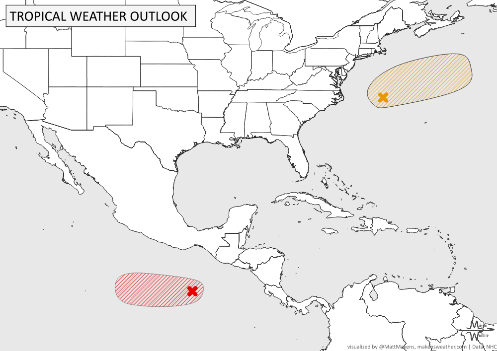
Atlantic (AL93): A powerful storm off the North Carolina coast has a 40% chance of briefly becoming subtropical as it moves north-northeast over the next couple of days. Regardless of development, strong winds, coastal flooding and dangerous surf will affect portions of the U.S. East Coast before the storm moves farther offshore late this week.
Eastern Pacific (EP94): A developing system south of Mexico has a 90% chance of becoming a tropical depression within the next 48 hours. It is expected to move west to northwest, remaining well offshore of the Mexican coast.
ARE YOU CIRRUS?!
In weather history:
1770: A powerful storm struck New England, causing extensive coastal damage from Massachusetts to Maine and producing the region's highest tides in 47 years.
1956: Temperatures at Esperanza Base, Antarctica, reached an unusually warm 57.2°F.
1983: Remnants of Hurricane Tico caused widespread flooding across central and southern Oklahoma. Oklahoma City recorded 6.28 inches of rain on October 20.
2004: Typhoon Tokage brought devastating flash floods and landslides to Japan, killing 55 people and leaving at least 24 missing.
A nor'easter will continue to cause problems along the Mid-Atlantic coast through midweek, with coastal flooding, beach erosion and dangerous marine conditions. Meanwhile, a storm moving into the West will pull unusually high amounts of moisture into the Southwest and Four Corners, increasing the risk of flash flooding Wednesday and Thursday. That storm will eventually spread rain and thunderstorms into the Plains this weekend, with some locally heavy rainfall possible. Snow is also likely in the higher elevations of the Sierra Nevada and Rockies. Temperatures will run cooler than normal across much of the West, while the Central U.S. stays unusually warm for late October. Another Pacific system will bring precipitation into the Northwest this weekend, and parts of Florida could see repeated rounds of heavy rain.