

Weekly Weather Watch: Tuesday, October 6th, 2026
We're two days away from a 121-year hurricane record, and one disturbance in the Gulf will test that 1905 record.
The weather pattern is about to make a pretty sharp turn across the country. California starts the week with unusual October heat, including highs well into the 90s and even lower 100s in the Central Valley. Meanwhile, much cooler fall air has reached the Great Lakes, Northeast, and Eastern Canada. The Gulf Coast and Southeast stay unsettled, and there’s that record to watch: a tropical depression is likely to develop over the Gulf this week and could strengthen as it moves northeast. If it becomes a hurricane after the 8th, 2026 will have the latest-first hurricane in the Atlantic Basin record.
Members received their October to December outlooks on October 1st. Also, some new videos have dropped to YouTube that may be of interest:

📈 The latest weekly and monthly outlooks 👉 Join Now to Access
HEADLINERS:
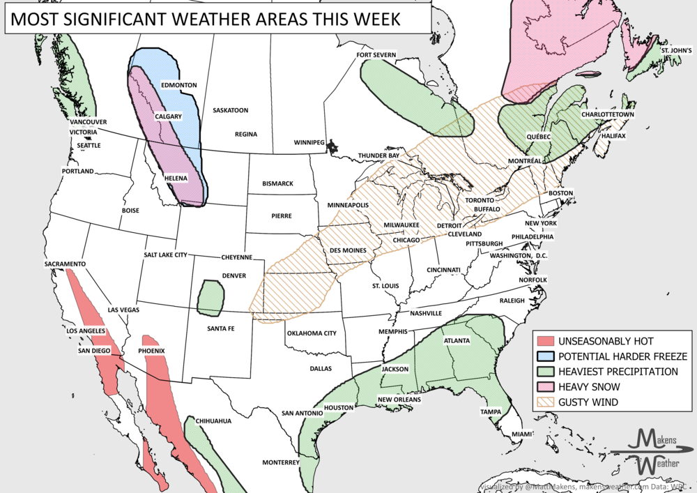
What to watch:
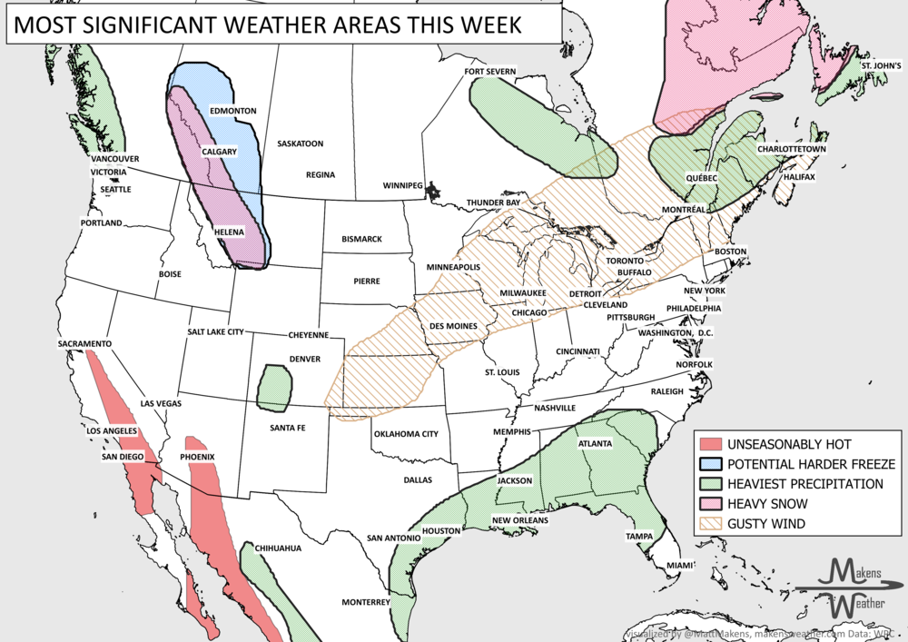
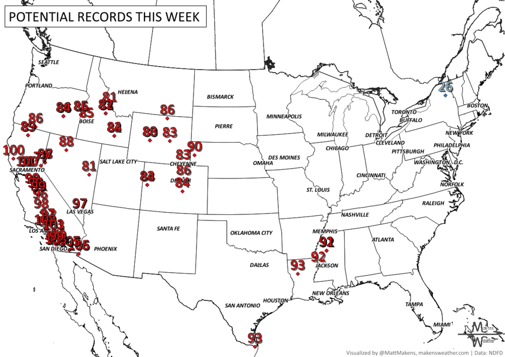
Tuesday-Wednesday: October heat continues across California, with temperatures running 15 to 20°F above normal in some areas. Parts of the Central Valley could reach the lower 100s, while coastal and urban areas climb well into the 90s.
Tuesday-Thursday: Much cooler air settles across the Great Lakes, Appalachians and Northeast. Frost and freezing temperatures are possible in some areas. The same system may drop heavy precipitation across northeastern Ontario and western Quebec.
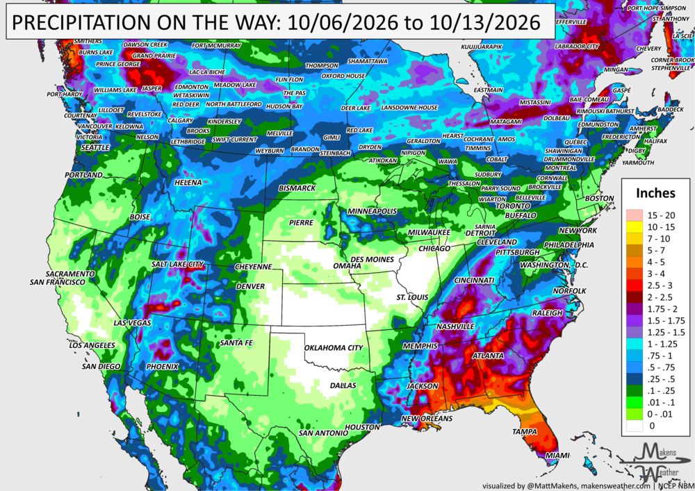
Tuesday-Thursday: Showers and thunderstorms continue across Florida, with locally heavy rain and isolated flooding possible.
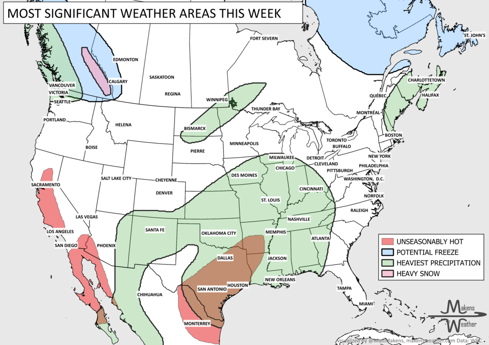
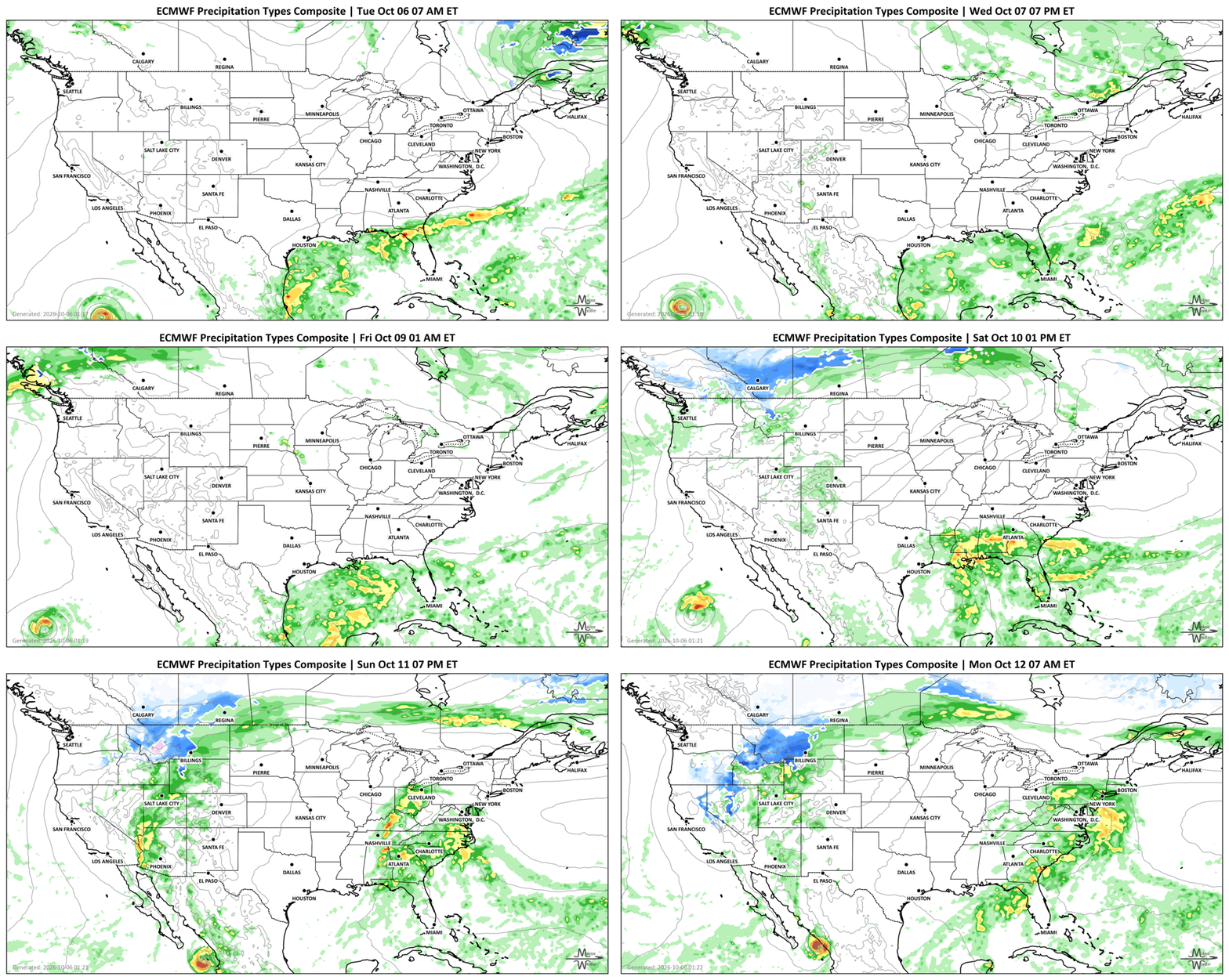
Wednesday-Friday: Watch the Gulf of America. A tropical depression is likely to form, with additional strengthening possible as it begins moving northeast. Its exact development and track will determine where the heaviest rain eventually sets up. Heavy precipitation forms in western Canada.
Friday-Saturday: Heavy rain becomes a bigger concern along the Gulf Coast and Southeast, where repeated thunderstorms could produce localized flash flooding. Heavy precipitation quickly scoots across Canada.
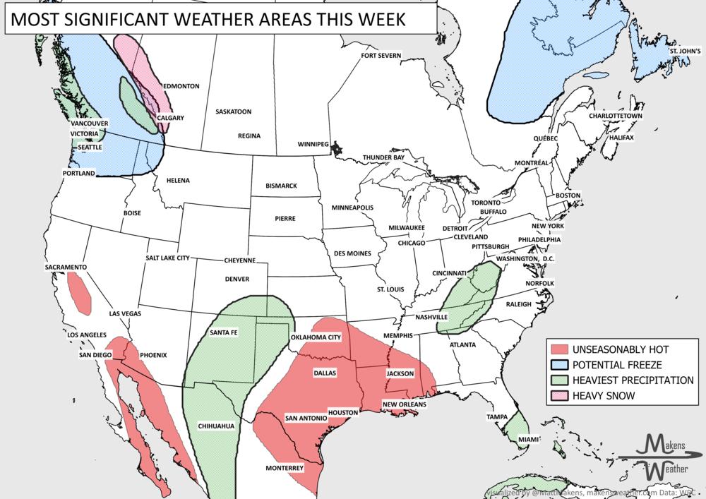
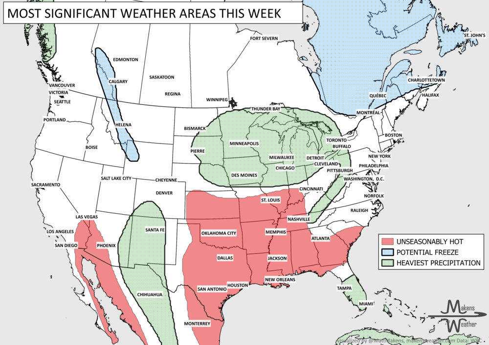
Weekend: The rain shifts farther north and east through parts of the Tennessee and Ohio Valleys, Southeast and Mid-Atlantic, eventually reaching portions of the Northeast. A harder freeze is possible across much of Canada.
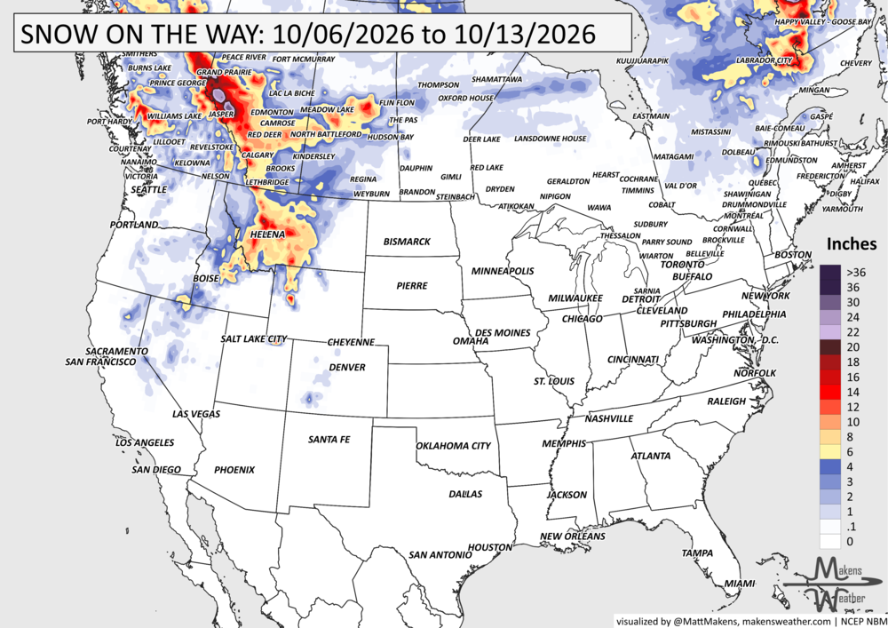
Friday-Early Next Week: A major change arrives across the West. The California heat breaks down as a colder Pacific system brings rain inland and lowers snow levels. Mountain snow could become moderate to heavy across portions of the Northwest and northern Rockies, with precipitation eventually spreading into the Intermountain West, Rockies and Southwest.
SET YOUR WATCHES - WHEN THE MOISTURE ARRIVES:
IN THE GAUGES, PRECIPITATION THROUGH THE 13TH:
GRAB A RULER, SNOWFALL THROUGH THE 13TH:
RECORDS MADE TO BE BROKEN, DAILY HIGHS (RED) | DAILY LOWS (BLUE):
UN-DROUGHTABLY DRY:
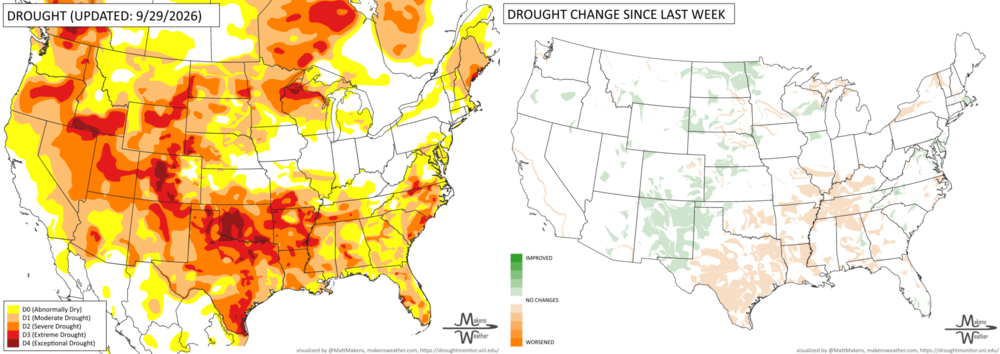
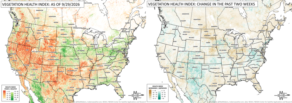
U.S. Drought: Heavy tropical rainfall brought significant drought improvement to New Mexico and parts of Arizona, Colorado, Kansas, Nebraska and western Texas. Meanwhile, persistent heat and dryness worsened drought across much of Texas, Oklahoma and the Southeast, with additional deterioration in northern Wisconsin and Michigan. Note: The heavy precipitation received across the Southern Plains is only partially accounted for here; the next update to the drought monitor is released this Thursday.
TRACKING THE TROPICS
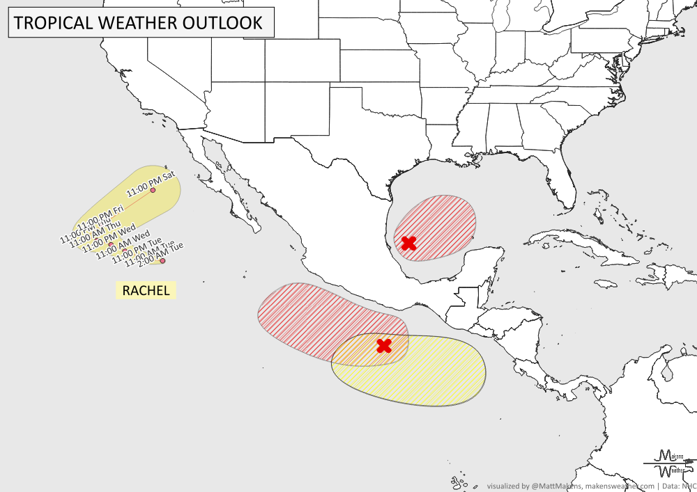
Southwestern Gulf: A tropical depression is likely to form within the next day or so as a disturbance drifts eastward. Heavy rain and gusty winds could affect the Yucatan Peninsula before the system turns north or northeast toward the northern Gulf Coast late this week. It’s too early for specific impacts, but areas from the Florida Panhandle to Louisiana should monitor the system closely. Formation chance is 90% through both 48 hours and 7 days.
Eastern Pacific: Hurricane Rachel remains well southwest of the Baja California Peninsula. Farther southeast, a tropical depression is likely to form off southern Mexico, with heavy rain possible regardless of development. Another disturbance could develop south of Guatemala early next week, but formation chances remain low.
ARE YOU CIRRUS?!
In weather history:
1952: Sleet fell at several locations in Arkansas, marking the state’s earliest documented winter precipitation.
1967: Brynnor Mines at Ucluelet recorded 19.3 inches of rain in one day, setting a Canadian rainfall record.
1981: An aircraft encountered a tornado within thunderstorms over the Netherlands, causing the right wing to separate. All 17 people aboard were killed.
2010: At least eight tornadoes struck northern Arizona, the most recorded in the state in a single day. One EF2 traveled 34 miles, the longest tornado track in Arizona history.
2016: Several tornadoes struck Kansas, including an EF2 and EF3 in Saline County.
2016: Category 4 Hurricane Matthew passed within 100 miles of Miami, Florida.
The weather pattern is about to make a pretty sharp turn across the country. California starts the week with unusual October heat, including highs well into the 90s and even lower 100s in the Central Valley. Meanwhile, much cooler fall air has reached the Great Lakes and Northeast. The Gulf Coast and Southeast stay unsettled, and there’s that record to watch: a tropical depression is likely to develop over the Gulf this week and could strengthen as it moves northeast. If it becomes a hurricane after the 8th, 2026 will have the latest-first hurricane in the Atlantic Basin record.