



Weekly Weather Watch: Tuesday, October 27th, 2026
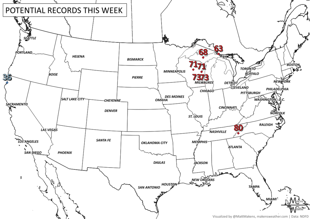
The weather pattern is getting more active as we head into November. Several storm systems will bring rain to much of the country over the next week, with mountain snow in the West and the possibility of some snow reaching the High Plains early next week. Texas faces a more immediate concern, with heavy thunderstorms and localized flooding possible through Thursday. Meanwhile, much of the central and eastern United States will stay unusually warm for late October, with temperatures running 10 to 20 degrees above average in some areas. The biggest forecast question involves a developing Pacific storm that could bring widespread precipitation to California and eventually strengthen over the central Plains.
The forecast doesn't stop at seven days. Neither should your planning.
Weekly Weather Watch gives you a look at what's coming. With a paid Makens Weather membership, you can go further, with more detailed weather outlooks, longer-range forecasts, and insight into the patterns shaping the weeks and months ahead.
Whether you're planning around weather for work, travel, or everyday life, get more of the information behind the forecast.
Explore Paid Membership → 📈 The latest weekly and monthly outlooks 👉 Join Now to Access
HEADLINERS:
What to watch:
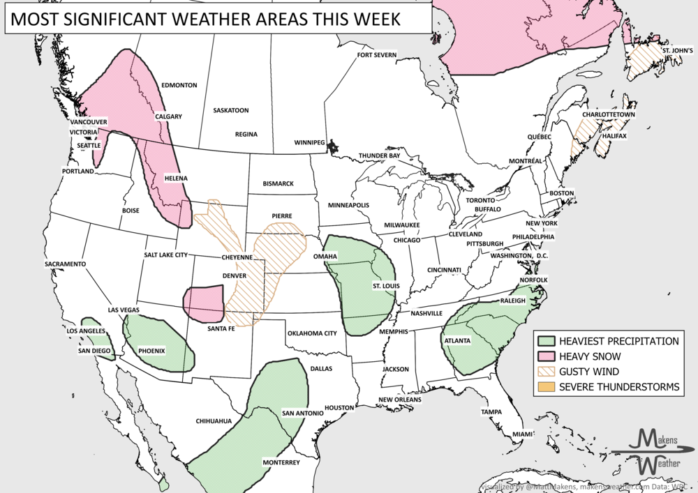
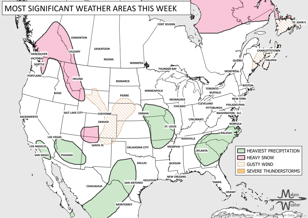
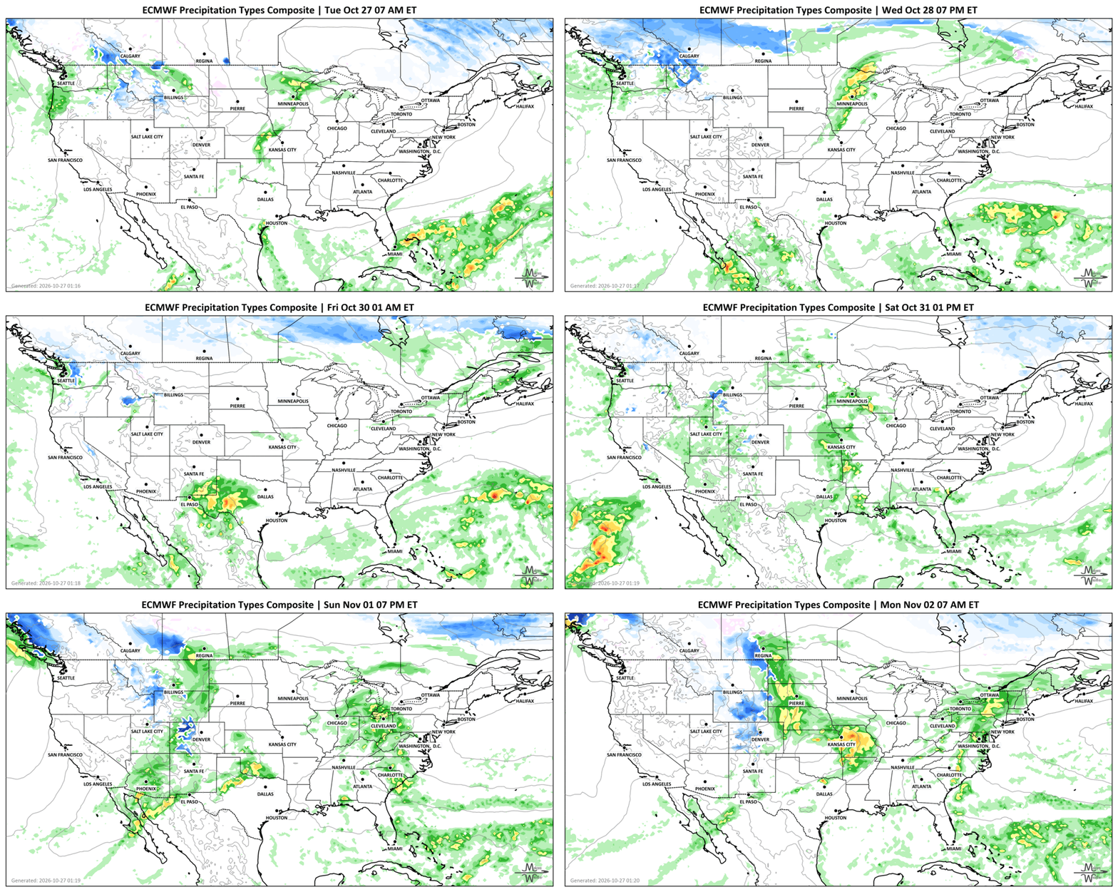
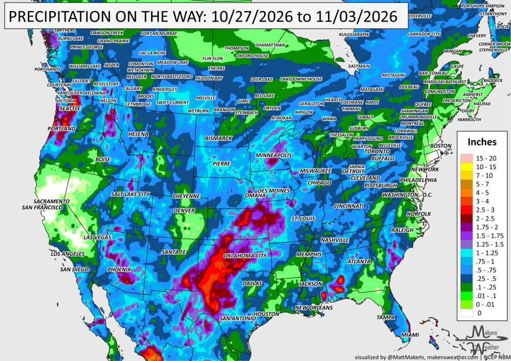
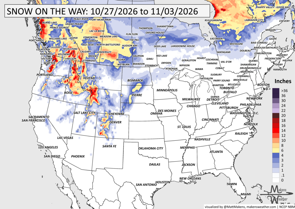
Tuesday-Thursday: Rain and higher-elevation snow continue across the Pacific Northwest and Northern Rockies. Heavy thunderstorms could produce localized flash flooding in Texas, especially Wednesday night into Thursday. Additional showers move across the Plains, Upper Midwest, and Great Lakes. Heavy precipitation in parts of British Columbia and Alberta, also toward Ontario and Quebec by Thursday.
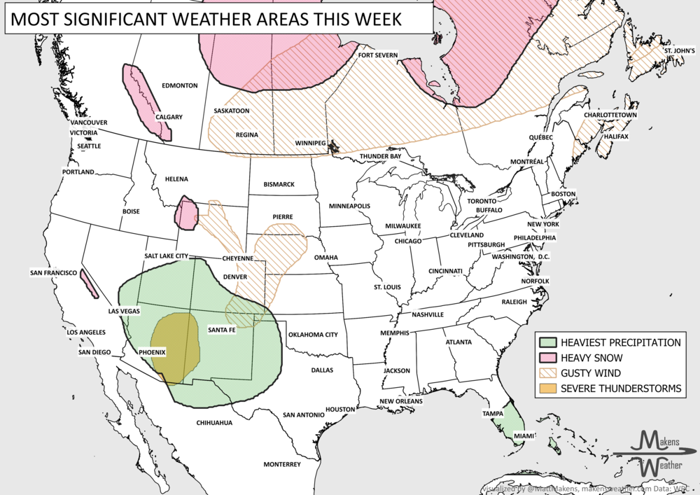
Friday-Saturday: Rain and thunderstorms spread from the southern Plains into the Mississippi Valley and Southeast, with locally heavy rainfall possible. Another push of Pacific moisture increases rain and mountain snow chances across California, the Southwest, and the Intermountain West. Heavy snow in parts of British Columbia and Quebec.
Sunday-Monday: A developing storm system could bring more widespread precipitation to the West before moving into the central United States. Rain becomes more likely across the Plains, while gusty winds and some rain/snow mix are possible in the northern and central High Plains. Heavy snow in areas across eastern Canada.
Tuesday, November 3: A stronger low-pressure system may organize over the central United States, bringing another round of widespread rain and potentially gusty winds. The exact storm track and the extent of any snow remain uncertain.
SET YOUR WATCHES - WHEN THE MOISTURE ARRIVES:
IN THE GAUGES, PRECIPITATION THROUGH THE 3RD:
GRAB A RULER, SNOWFALL THROUGH THE 3RD:
RECORDS MADE TO BE BROKEN, DAILY HIGHS (RED) | DAILY LOWS (BLUE):
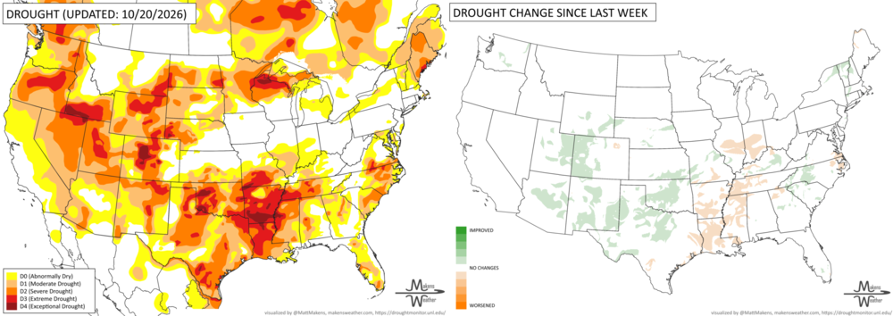
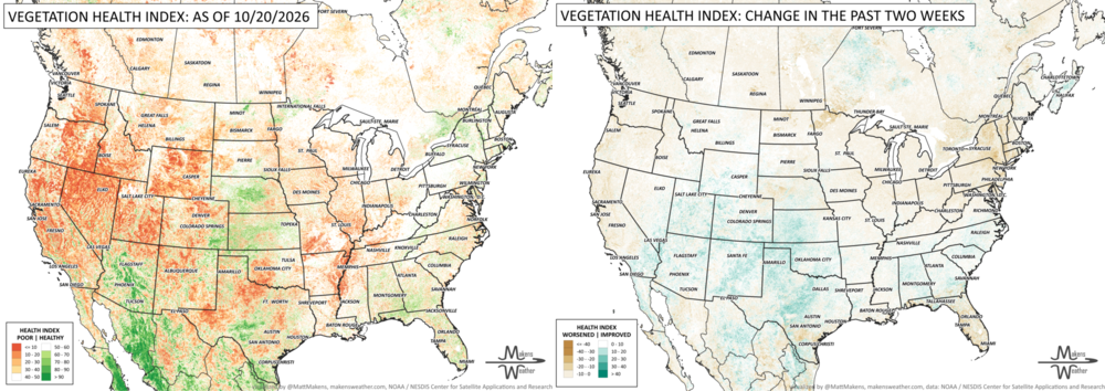
UN-DROUGHTABLY DRY:
Drought conditions improved across much of the central and western U.S., particularly Texas and Oklahoma, where heavy rainfall brought substantial relief. Additional improvements occurred across the Rockies, Southwest and Southeast. Meanwhile, drought worsened from the Lower Mississippi Valley into the western Ohio Valley, where persistent dryness and low streamflows increased wildfire concerns. Temperatures averaged 2 to 6 degrees above normal across much of the northern U.S., while precipitation ranged from less than 25% to more than 400% of normal in some areas.
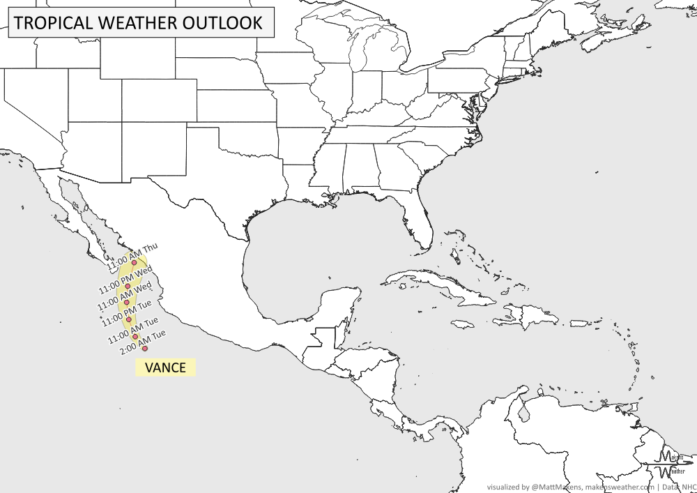
TRACKING THE TROPICS
The National Hurricane Center is issuing advisories on Tropical Storm Vance, located a couple hundred miles southwest of Manzanillo, Mexico.
ARE YOU CIRRUS?!
In weather history:
1913: A destructive tornado struck South Wales, traveling from Edwardsville to Cilfynydd. The Abercynon Tornado killed at least three people, injured more than 100, and tore roofs from entire rows of homes.
2006: An F1 waterspout moved ashore near Apalachicola, Florida, causing significant damage on the western side of the city.
The weather pattern is getting more active as we head into November. Several storm systems will bring rain to much of the country over the next week, with mountain snow in the West and the possibility of some snow reaching the High Plains early next week. Texas faces a more immediate concern, with heavy thunderstorms and localized flooding possible through Thursday. Meanwhile, much of the central and eastern United States will stay unusually warm for late October, with temperatures running 10 to 20 degrees above average in some areas. The biggest forecast question involves a developing Pacific storm that could bring widespread precipitation to California and eventually strengthen over the central Plains.