
Weekly Weather Watch: Tuesday, November 17th, 2026
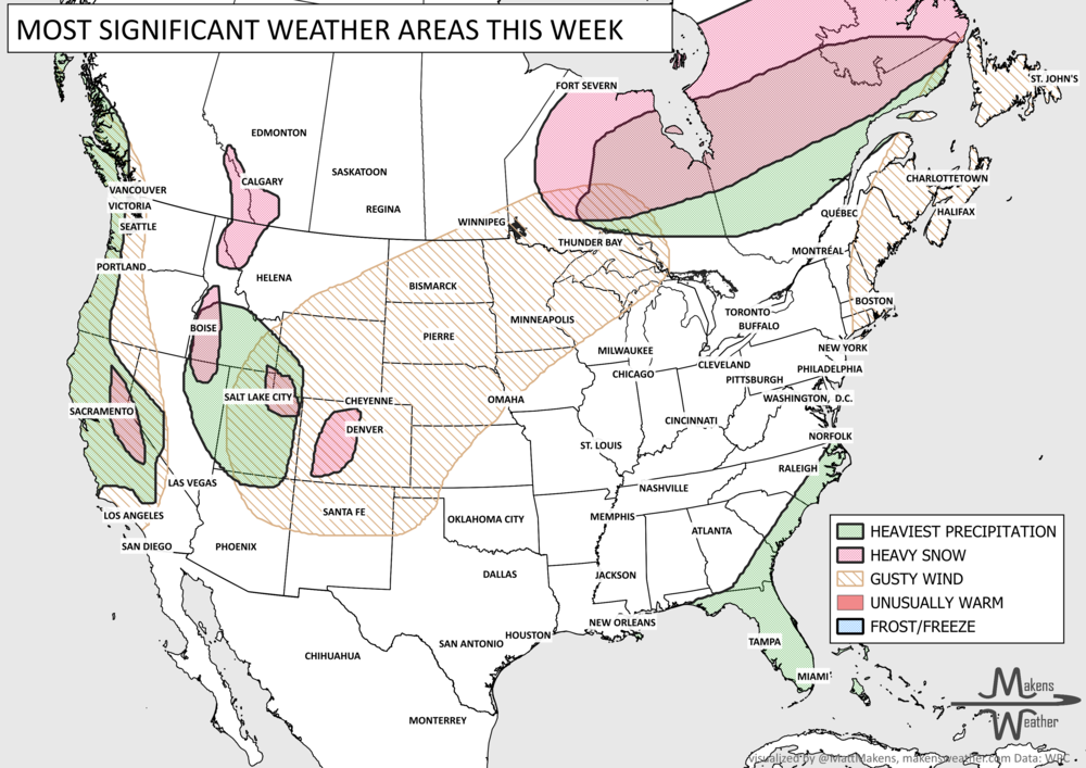
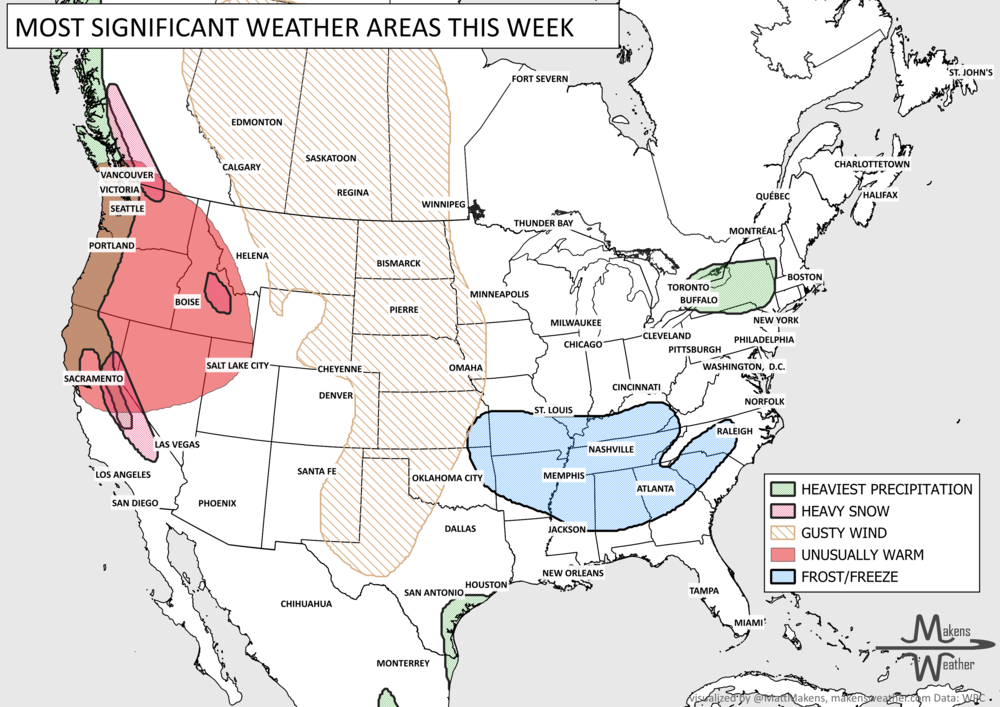
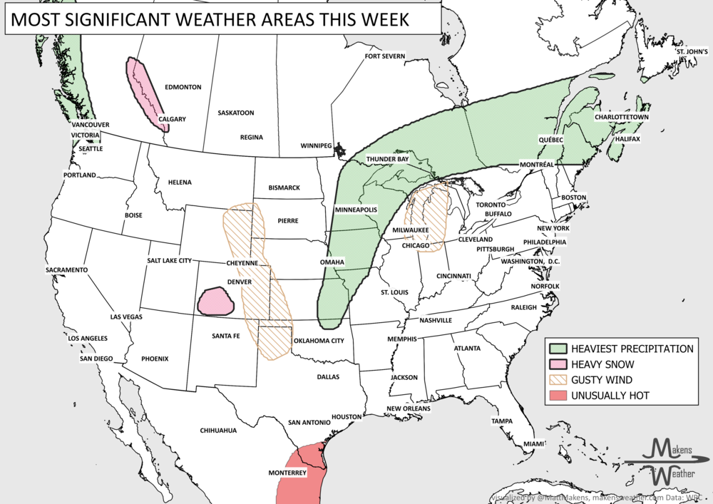
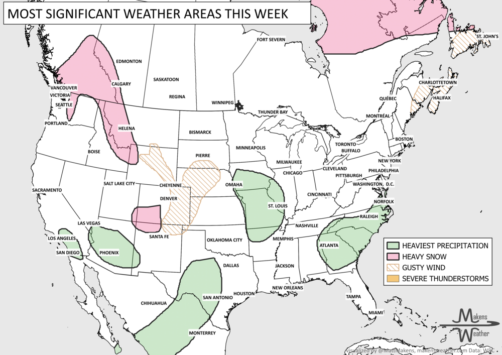
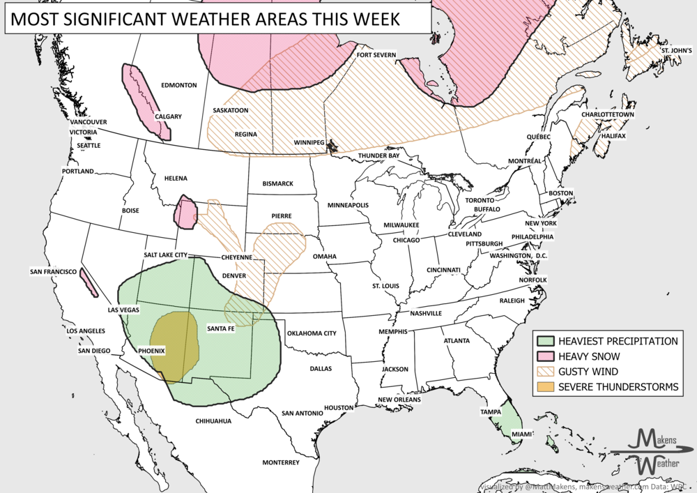
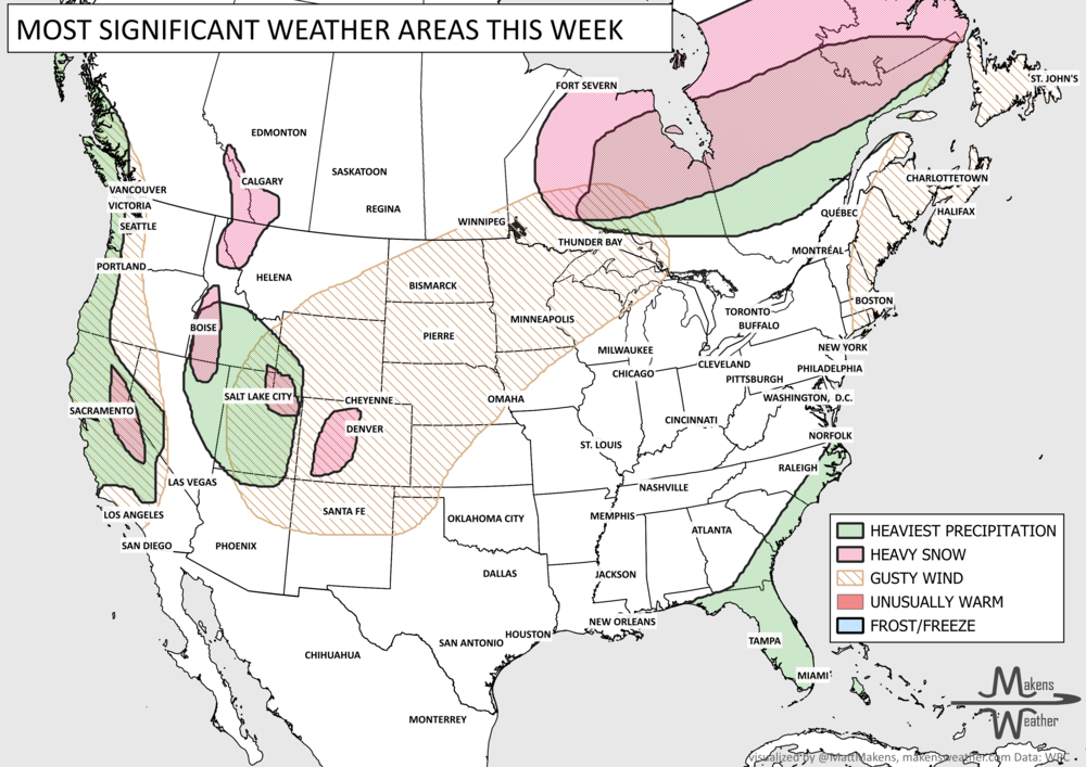
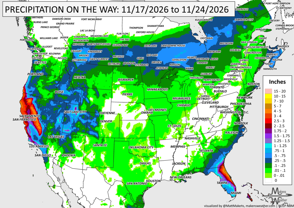
Heavy rainfall and flooding will be the biggest weather concerns this week, especially along Florida's Atlantic Coast, where repeated downpours could cause flash and urban flooding from St. Augustine to Palm Beach. Meanwhile, a series of Pacific storms will bring heavy rain to California and significant mountain snow to the Sierra Nevada. Snow and gusty winds will also affect parts of the Rockies as unsettled weather spreads toward the Plains and Midwest. Looking toward the weekend, a developing storm off the Southeast Coast could bring additional rain, wind, and coastal flooding farther north along the Eastern Seaboard, although its track remains uncertain.
📈 The latest weekly and monthly outlooks 👉 Join Now to Access
HEADLINERS:
TIMELINE to watch:
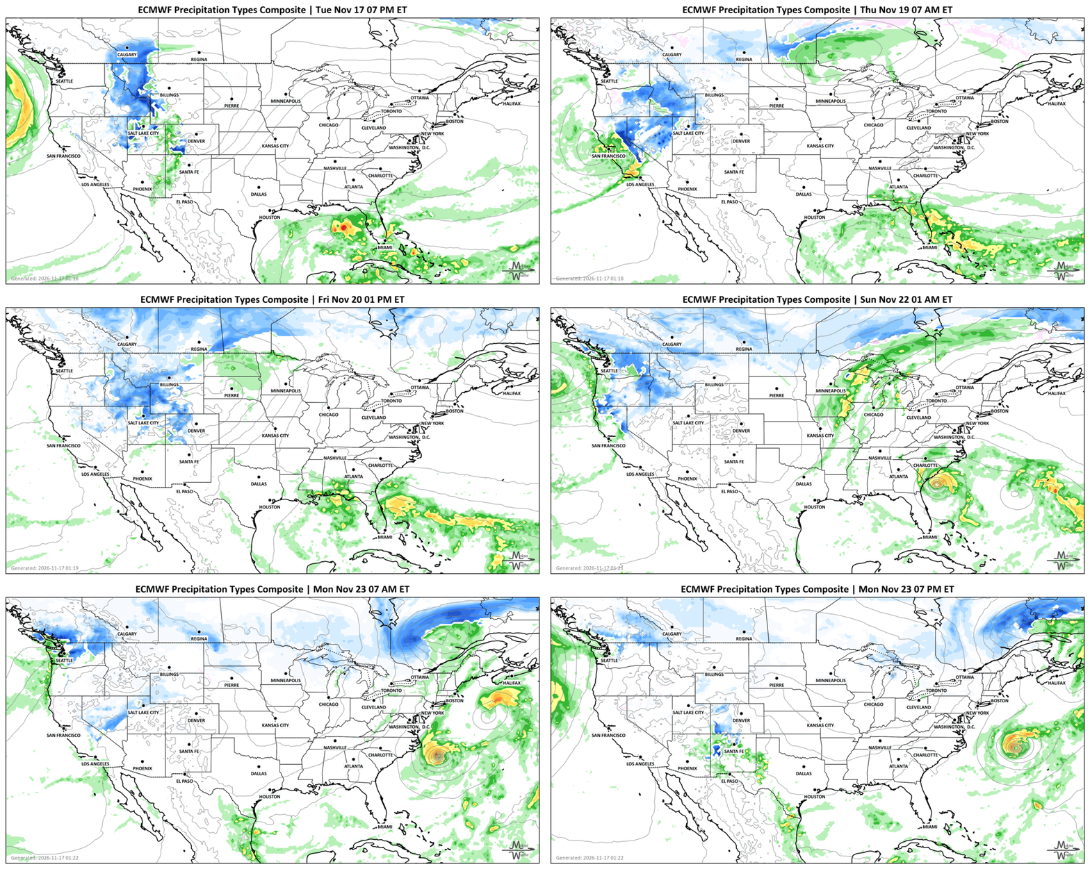
Tuesday-Wednesday: Heavy showers and thunderstorms continue along Florida's Atlantic Coast, particularly from St. Augustine to Palm Beach. The flooding risk increases on Wednesday.
Tuesday-Thursday: Another Pacific storm brings widespread rain to California and the Pacific Northwest, with heavy snow in the Sierra Nevada. Gusty winds and snowfall could make mountain travel a pain. Heavy rain may also cause flooding along the Central California Coast and parts of the Southwest. Areas of precipitation will develop over Southern Alberta and spread across the Canadian Prairies toward Ontario and Quebec.
Friday-Saturday: Rain and mountain snow spread from the Intermountain West into the Northern Plains, Midwest, and Great Lakes.
Weekend: A developing coastal storm could bring additional rainfall to Florida and potentially farther north along the East Coast. Coastal winds and flooding are possible if the storm tracks close enough to shore. Snow and rain/snow continue across Canada, the heaviest from Quebec to the Maritimes/Labrador.
Sunday-Tuesday: Additional Pacific storms keep California wet, with more chances for mountain snow across the West.
Regional Weather Highlights
Florida and the East Coast: The immediate concern is flooding along Florida's Atlantic Coast. Moisture flowing inland from the Atlantic will support repeated showers and thunderstorms through Wednesday. Some locations could receive heavy rain over already saturated ground, increasing the potential for urban and flash flooding. The threat may continue into the weekend as low pressure develops offshore. How far north the rain and coastal impacts spread will depend on the storm's track.
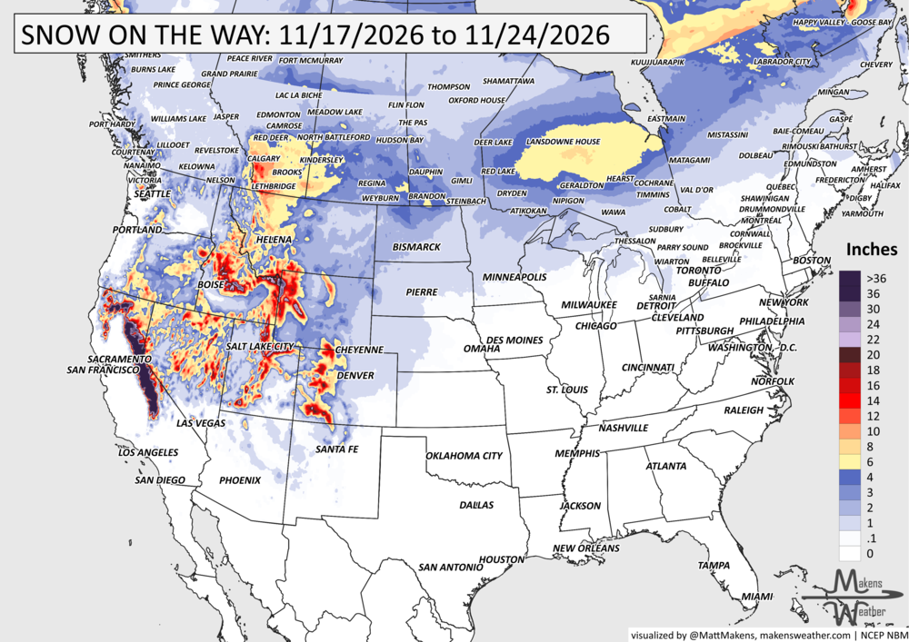
California and the West: Several Pacific systems will keep the weather active. Heavy rainfall is expected along portions of the California coast, while the Sierra Nevada receives substantial snowfall. Gusty winds will make matters worse. Another round is expected over the weekend, followed by another storm potential early next week.
Rockies, Plains, and Midwest: The first western storm will move east late this week, bringing precipitation into the northern and central U.S. Mountain snow, gusty winds, and some lower-elevation snow across the Northern Plains. The next western system could bring more precipitation to the Central U.S. early next week.
Canada: Areas of rain/snow will cross the country, some of the heaviest pockets over Southern Alberta, the Prairies, and Eastern Quebec.
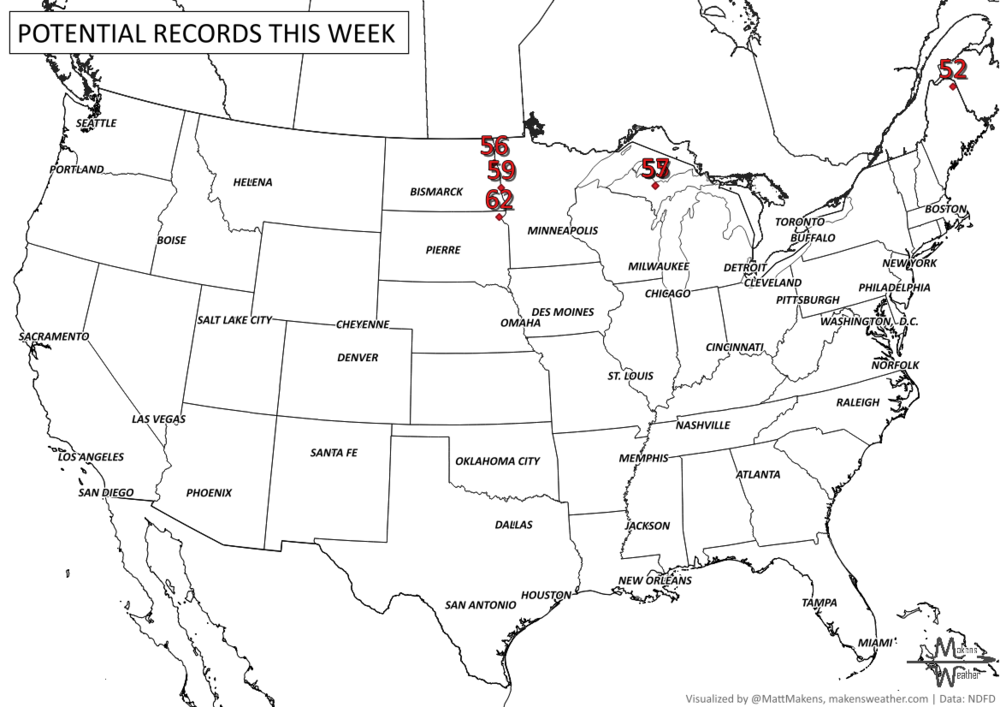
Temperatures: Cooler-than-normal conditions across California and the Great Basin. Meanwhile, much of the eastern half of the country will be warmer than average, particularly the Upper Midwest and Great Lakes, where afternoon highs could reach the 60s. Temperatures should settle closer to normal following a system early to mid next week.
What This Means
Florida flooding: Repeated heavy rain could overwhelm drainage systems and flood roads, especially in urban areas along the Atlantic Coast.
Western mountain travel: Heavy Sierra Nevada snowfall and gusty winds may cause hazardous travel conditions through midweek.
California rainfall: Several rounds of rain will help bring moisture to the region, but heavier downpours could produce localized flooding.
Northern Plains snow: Snow and wind could create travel problems late this week, depending on the storm's eventual track.
East Coast uncertainty: A developing coastal storm bears watching this weekend. A track closer to shore would increase the threat of rain, wind, and coastal flooding.
Bottom Line
Florida's Atlantic Coast faces the greatest immediate flooding concern, with heavy rain continuing through midweek and possibly into the weekend. In the West, repeated Pacific storms will bring beneficial moisture but also heavy Sierra Nevada snow, gusty winds, and travel issues. To watch: a developing coastal storm tracks close enough to bring more widespread impacts along the East Coast this weekend.
SET YOUR WATCHES - WHEN THE MOISTURE ARRIVES:
IN THE GAUGES, PRECIPITATION THROUGH THE 24TH:
GRAB A RULER, SNOWFALL THROUGH THE 24TH:
RECORDS MADE TO BE BROKEN, DAILY HIGHS (RED) | DAILY LOWS (BLUE):
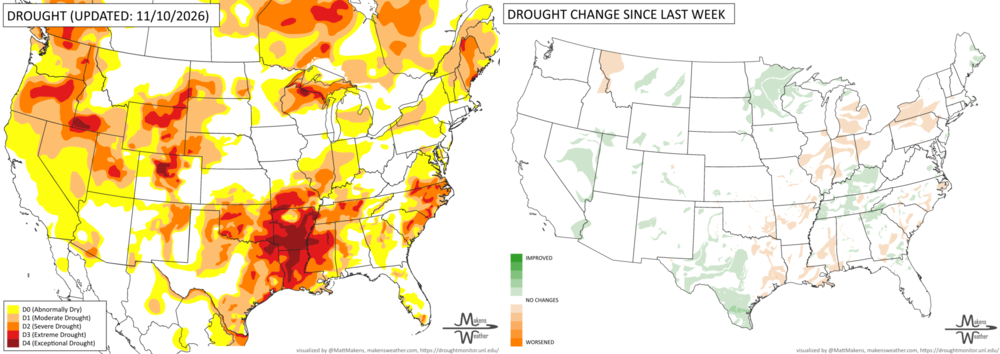
UN-DROUGHTABLY DRY:
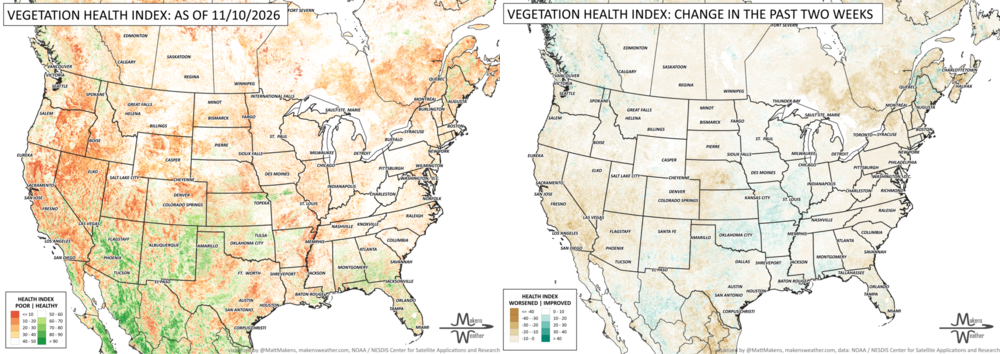
Drought worsened across the Lower Mississippi Valley and Lower Great Lakes, while heavy rainfall improved conditions in southern and western Texas, the Southern Appalachians, and parts of the Upper Great Lakes. Recent widespread rainfall also continued to ease drought across the Four Corners region, where flooding and rapidly filling reservoirs show just how quickly moisture conditions have changed.
For winter wheat, 53% is rated good-to-excellent, but 48% of acreage is still in drought heading into dormancy. Season-end pasture finished at just 23% good-to-excellent, the third-lowest since 1995.
ARE YOU CIRRUS?!
In weather history:
1927: A tornado carved a 17-mile path through Virginia, Washington, D.C., and Maryland, injuring 31 people. The tornado reached 260 yards wide and produced a recorded 93 mph wind gust at the Naval Air Station.
2013: A powerful storm system produced roughly 60 tornadoes from the Great Lakes to the Tennessee Valley. Two EF4 tornadoes struck Illinois, causing significant damage in Washington and New Minden.
Florida's Atlantic Coast faces the greatest immediate flooding concern, with heavy rain continuing through midweek and possibly into the weekend. In the West, repeated Pacific storms will bring beneficial moisture but also heavy Sierra Nevada snow, gusty winds, and travel disruptions. The next forecast question is whether a developing coastal storm tracks close enough to bring more widespread impacts along the East Coast this weekend.