
Weekly Weather Watch: Tuesday, November 3rd, 2026
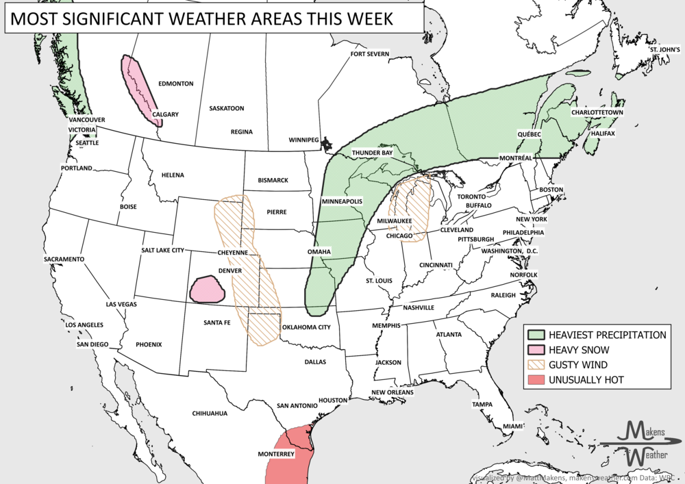
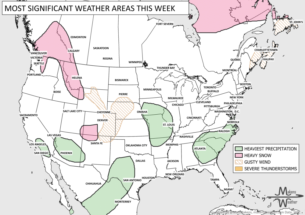
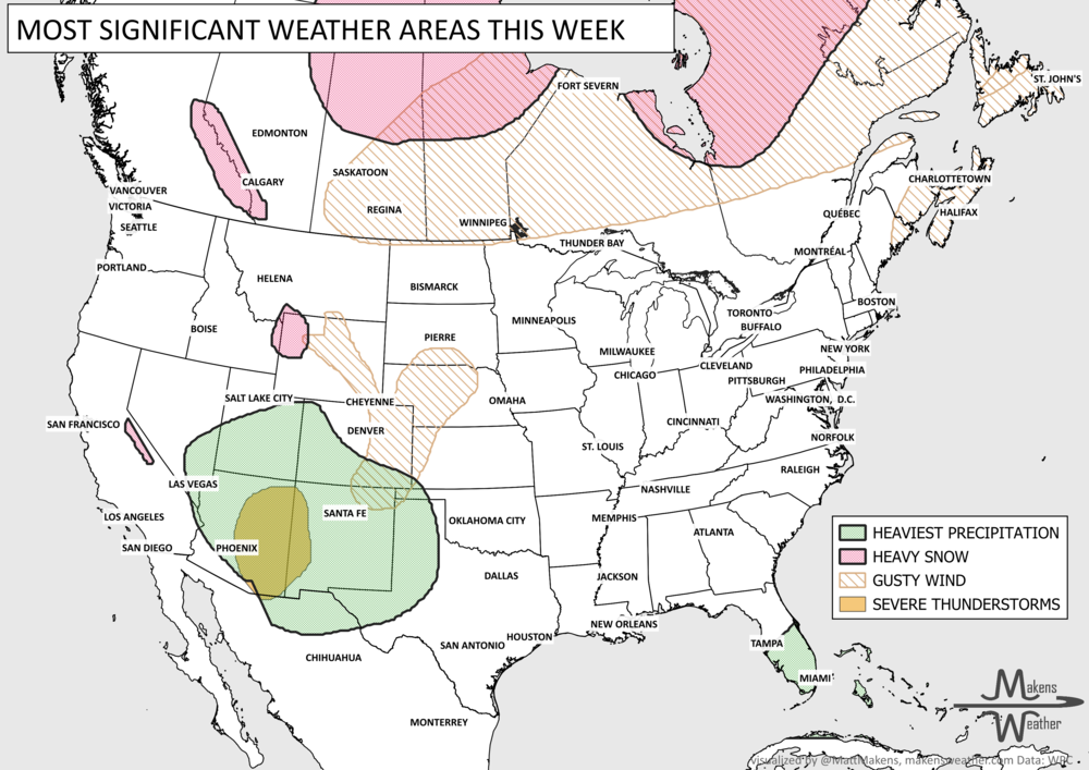
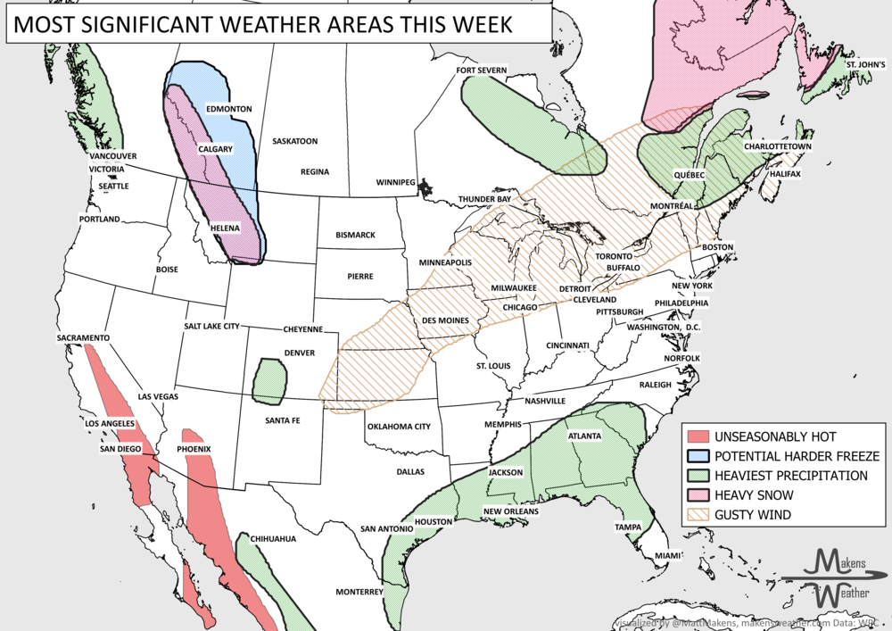
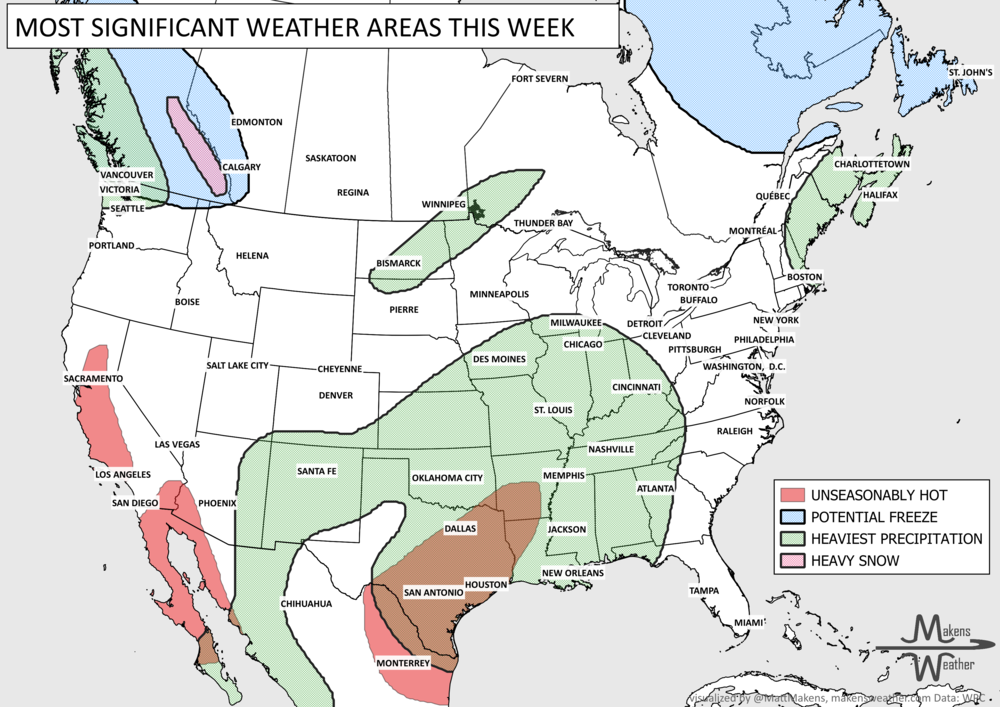
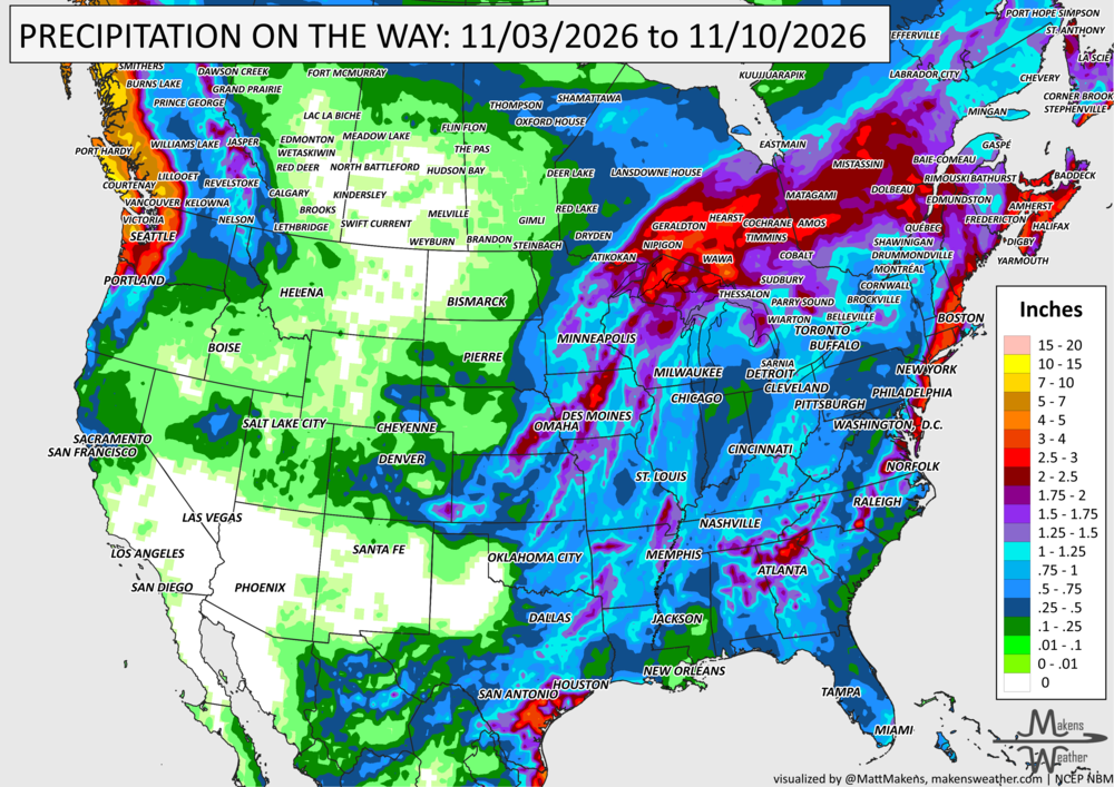
An active stretch of weather is underway, with heavy rain and a few severe thunderstorms moving through the Mississippi Valley before spreading into the East later this week; areas from the Great Lakes to the Northeast and Eastern Canada will have heavy showers. South Florida faces another round of heavy rainfall following recent flooding, while a series of Pacific storms will keep parts of the Northwest wet. Some mountain snow is possible in the Central Rockies, and another system could bring showers and thunderstorms to the Southern Plains this weekend. Temperatures will remain cooler than average across parts of the West, while much of the East stays unusually mild before the cold front moves through.
Winter Outlook: Winter 2026-27 Outlook: El Niño and the Drought
The forecast doesn't stop at seven days. Neither should your planning.
Weekly Weather Watch gives you a look at what's coming. With a paid Makens Weather membership, you can go further, with more detailed weather outlooks, longer-range forecasts, and insight into the patterns shaping the weeks and months ahead.
Whether you're planning around weather for work, travel, or everyday life, get more of the information behind the forecast.
Explore Paid Membership → 📈 The latest weekly and monthly outlooks 👉 Join Now to Access
HEADLINERS:
What to watch:
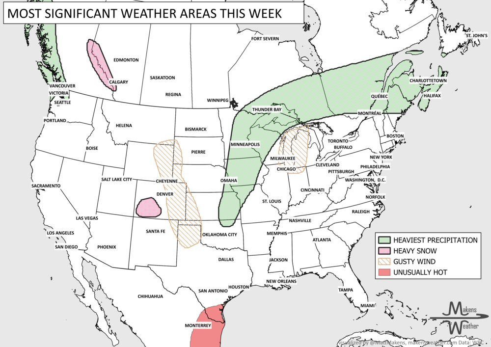
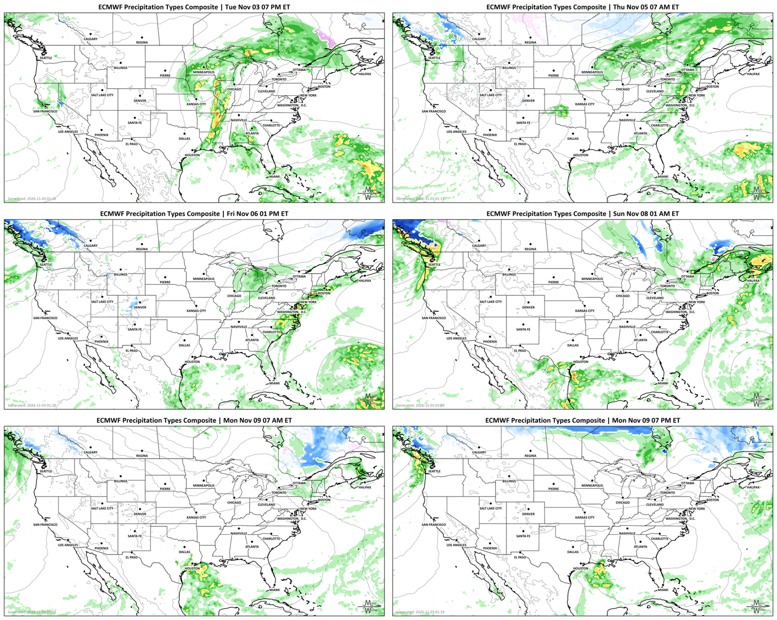
Tuesday–Wednesday: Heavy rain and thunderstorms spread across the Middle and Lower Mississippi Valley, with isolated damaging wind gusts and a brief tornado or two possible. Gusty winds will also accompany the storm system. Additional heavy showers and thunderstorms for South Florida, particularly southeastern areas where flooding has already occurred.
Wednesday–Thursday: The storm system moves toward the Northeast and Mid-Atlantic, bringing rain to areas that have been relatively dry, with continued moisture for parts of Quebec and the Maritimes. Meanwhile, some mountain snow is possible in the Central Rockies.
Friday: Rain and thunderstorms continue along parts of the East Coast, with localized flooding possible in the Northeast if the cold front slows or stalls.
Friday–Weekend: Another system brings scattered showers and thunderstorms to the Southern Plains and western Gulf Coast.
Weekend–Monday: Several Pacific systems bring periods of rain to Washington and Oregon, with precipitation extending into the Cascades and possibly portions of the Northern Rockies. Another system could bring additional showers to parts of the Eastern U.S., depending on how it develops.
SET YOUR WATCHES - WHEN THE MOISTURE ARRIVES:
IN THE GAUGES, PRECIPITATION THROUGH THE 10TH:
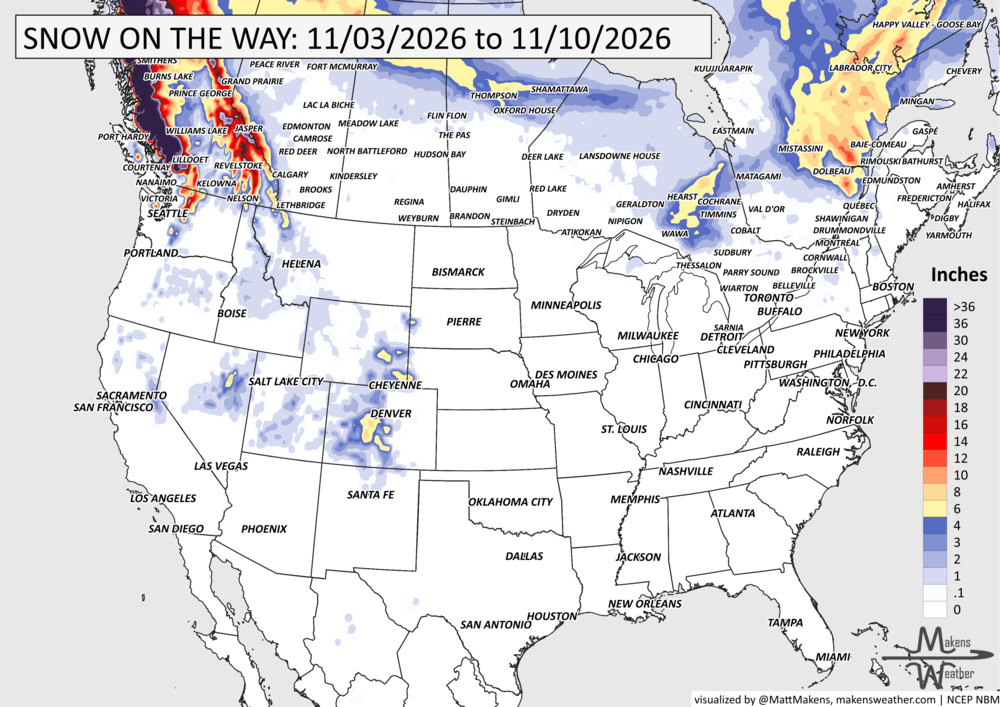
GRAB A RULER, SNOWFALL THROUGH THE 10TH:
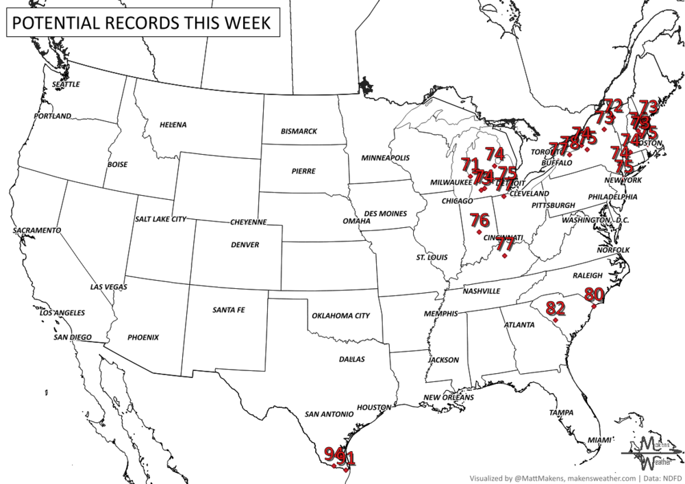
RECORDS MADE TO BE BROKEN, DAILY HIGHS (RED) | DAILY LOWS (BLUE):
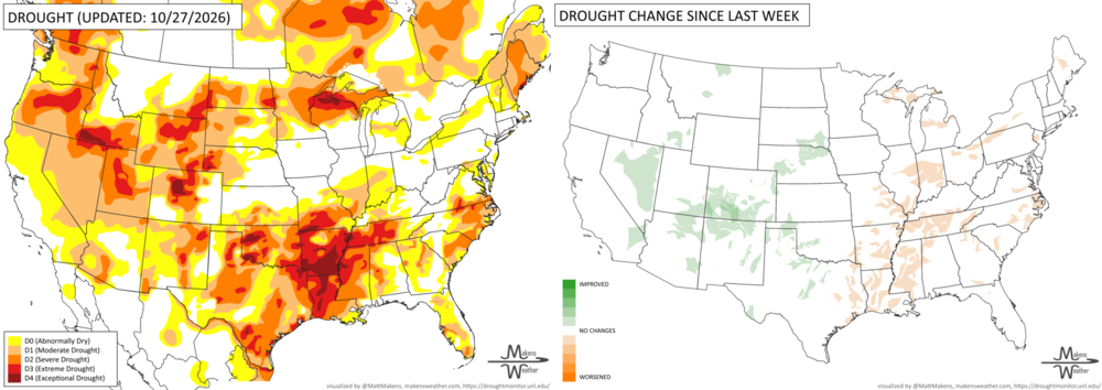
UN-DROUGHTABLY DRY:
Dry weather dominated much of the eastern U.S. last week, with worsening drought conditions from the southern Mississippi Valley to the Mid-Atlantic. Out west, widespread precipitation brought drought relief, especially across the Four Corners region, where some areas near the Colorado/New Mexico border received 4–8 inches of precipitation. Significant drought improvements were noted across the region, including a two-category improvement in parts of southern Colorado.
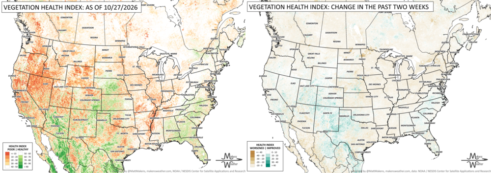
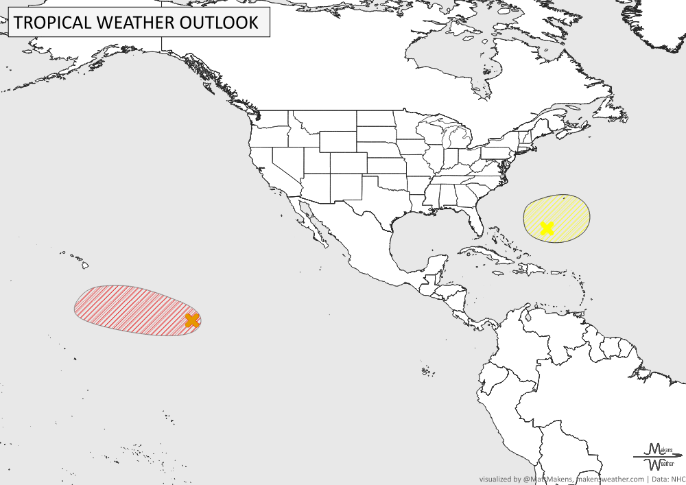
TRACKING THE TROPICS
Western Atlantic: An area of low pressure is expected to develop south of Bermuda over the next day or two. It could briefly become a subtropical system later this week, but conditions should become less favorable by the weekend. The chance of development remains low, at 10% over the next 48 hours and 30% over the next seven days.
Central Pacific: A developing area of low pressure well southeast of Hawaii has a better chance of becoming a tropical depression over the next several days. The system is expected to move west to northwest at 10–15 mph, gradually approaching the Central Pacific basin. Development chances are 40% over the next 48 hours and 70% over the next seven days. This system bears watching, although it's too early to determine whether it will pose any threat to Hawaii.
ARE YOU CIRRUS?!
In weather history:
1927: Historic flooding devastated Vermont between November 2–4, washing away 1,285 bridges along with roads, railways, and buildings. The flooding killed 84 people, including the state's lieutenant governor.
1966: An unusually early snowstorm spread from Alabama to Michigan. Louisville, Kentucky, received 13.1 inches, Nashville recorded 7.2 inches, and Huntsville, Alabama, measured 4 inches. Mobile reported its earliest snowflakes on record.
2001: Hurricane Michelle reached Category 4 intensity before striking Cuba on November 4–5. It was the strongest hurricane to hit the country since 1952, causing an estimated $2 billion in damage.
2002: A magnitude 7.9 earthquake struck central Alaska, ranking among the strongest earthquakes recorded in the United States.
2007: Dense Tule fog caused a massive 100-vehicle pileup near Fowler, California, killing two people and injuring 41 others.
2011: Tropical Depression Keila brought deadly flooding to Oman, where heavy rainfall caused several fatalities.
2013: Several tornadoes struck the area around Arnhem, Netherlands, during an outbreak of severe weather.
An active stretch of weather is underway, with heavy rain and a few severe thunderstorms moving through the Mississippi Valley before spreading into the East later this week. South Florida faces another round of heavy rainfall following recent flooding, while a series of Pacific storms will keep parts of the Northwest wet. Some mountain snow is possible in the Central Rockies, and another system could bring showers and thunderstorms to the Southern Plains this weekend. Temperatures will remain cooler than average across parts of the West, while much of the East stays unusually mild before the cold front moves through.