


Weekly Weather Watch: Tuesday, March 10th, 2026
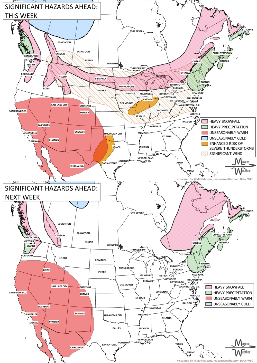
An active weather pattern is unfolding across much of the United States and Canada this week. Severe thunderstorms and flooding rains will develop from the Plains into the Midwest, while late-season snow and icy conditions affect parts of the Upper Midwest, Great Lakes, northern New England, and eastern Canada. Meanwhile, the Pacific Northwest faces heavy rain and mountain snow, including parts of BC and AB, and unusually warm spring temperatures continue across much of the East and Southwest.
Several storm systems will move across the country through mid-week and into the weekend, bringing a mix of severe storms, winter weather, heavy rain, and record-setting warmth depending on location.
Unlock the Makens Weather Advantage ☀️📊
Your membership includes:
✔️ Real-time dashboard with the latest weather observations and long-range projections
✔️ Monthly-lead forecasts to plan weeks ahead
✔️ Discounts on personalized consultations for ag, energy, or risk planning
All built for decision-makers who need weather insight, not just data.
🎯 Join now and put the forecast to work for you.
📈 The latest outlooks and conditions - track it 👉 Join Now to Access the Dashboard
HEADLINERS:
WHAT TO WATCH:
Tuesday (March 10)
• Severe thunderstorms likely across central Texas, southern Oklahoma, and the Missouri Valley, with risks of large hail, damaging winds, and a few tornadoes
• Heavy rain may trigger flash flooding across central Texas into southern Oklahoma
• Additional flooding risk from northern Missouri into southern Michigan
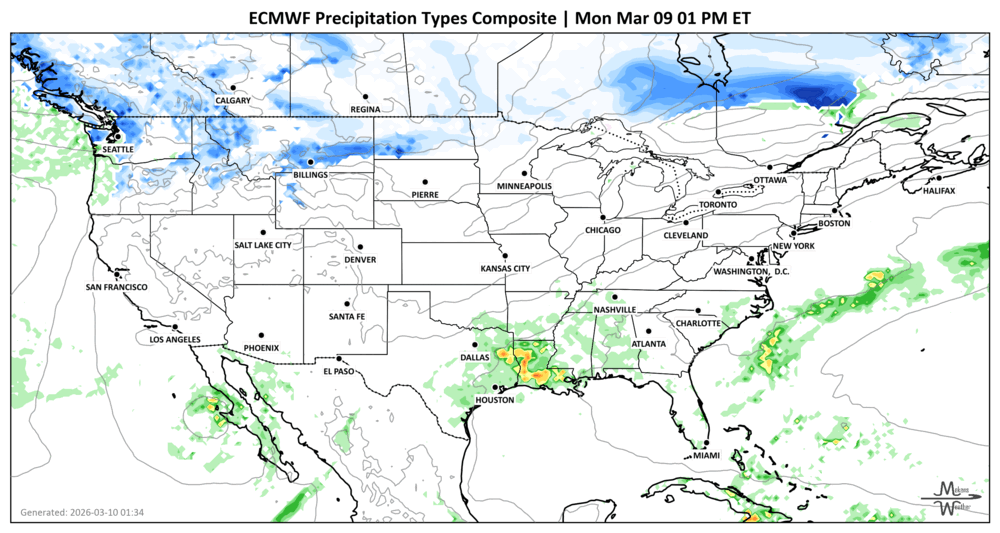
• Wintry mix develops across the Great Lakes
Tuesday Night – Wednesday (March 10–11)
• Storms shift east into the Ohio Valley, Tennessee Valley, and Lower Mississippi Valley with damaging wind risk
• Flooding rains possible across the ArkLaTex region
• Snow and ice expand from the Great Lakes into northern New England and the Maritimes
Wednesday – Thursday (March 11–12)
• Heavy rain and mountain snow increase across the Pacific Northwest and northern Rockies
• Several feet of snow possible in the Cascade and Olympic Mountains
• Gusty winds and localized flooding possible along the British Columbia, Washington, and Oregon coasts
Friday – Saturday (March 13–14)
• Developing storm spreads snow and gusty winds across the Canadian Prairies, Northern Plains, Upper Midwest, and Great Lakes
• Heavy mountain snow continues across the Rockies
Weekend into Early Next Week (March 15–17)
• Another system may bring moderate to heavy snow from the northern Plains to the Upper Midwest and Great Lakes
• Widespread precipitation develops ahead of a cold front moving into the central and eastern U.S out of Central/Western Canada.
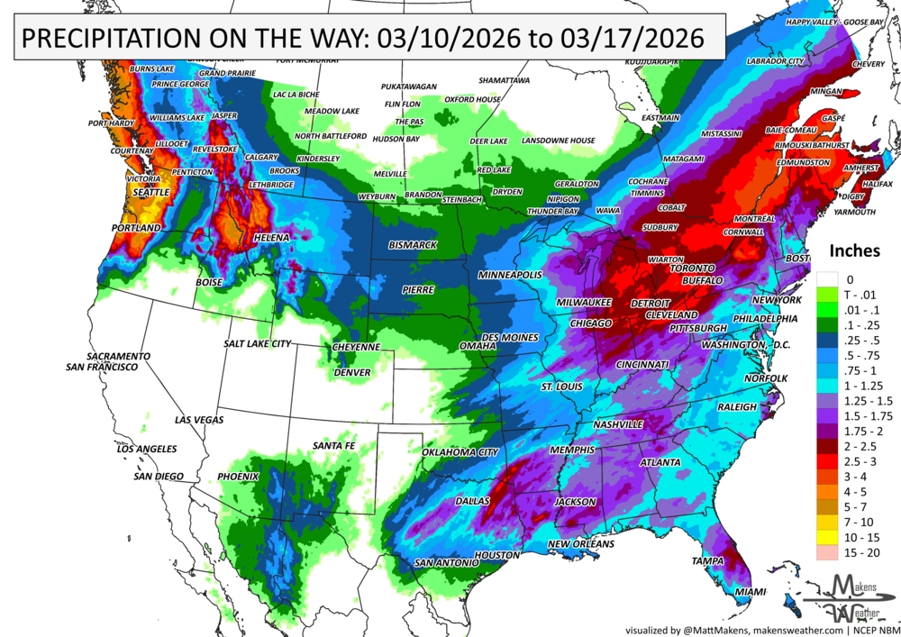
IN THE GAUGES, PRECIPITATION THROUGH THE 17th:
NOTE*** due to the convective (thunderstormy) nature of much of the rainfall across the South and East, the precipitation estimates show potential and do not accurately represent how isolated many of the rainfall totals will be due to the scattered behavior of thunderstorms.
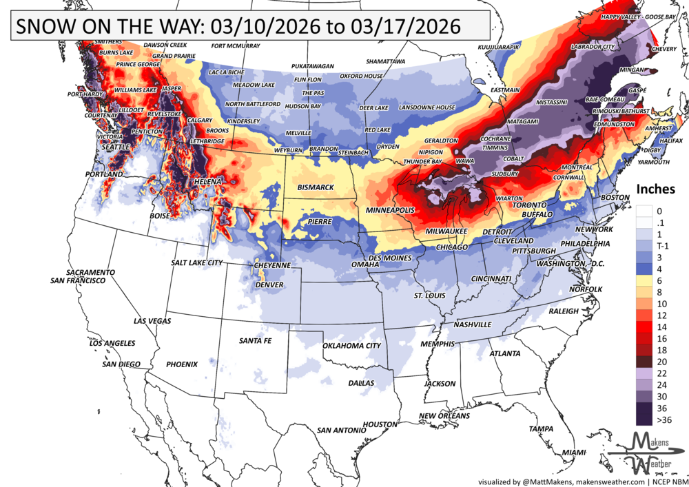
GRAB A RULER, SNOWFALL THROUGH THE 17th:
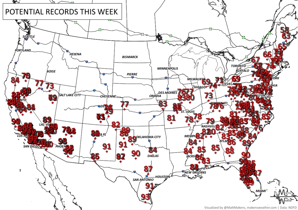
RECORDS MADE TO BE BROKEN, DAILY HIGHS (RED) | DAILY LOWS (BLUE):
• Eastern U.S. will see unusually warm spring temperatures through mid-week, with highs in the 70s and even 80s across parts of the Southern Plains and Southeast. Several daily records may be tied or broken.
• Southwest and Southern California could see near-90° temperatures late this week and into next week as high pressure builds.
• Cooler air follows storm systems across the Northern Plains, Midwest, and Great Lakes, with temperatures dropping to more seasonal levels by early next week.
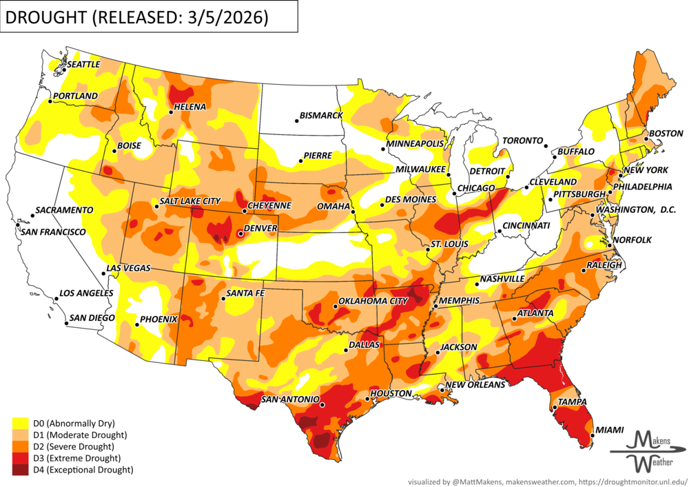
UN-DROUGHTABLY DRY:
Since December 2025, drought has expanded and intensified across the Lower Mississippi Valley and Southern Great Plains, which is fairly typical during a La Niña winter. Some much-needed rain in late February helped bring small improvements across parts of the Southeast and briefly slowed the drought’s expansion.
However, severe to extreme drought still covers much of the Carolinas, Georgia, southeastern Alabama, and Florida. Longer-term drought also continues across parts of the Mid-Atlantic and Northeast.
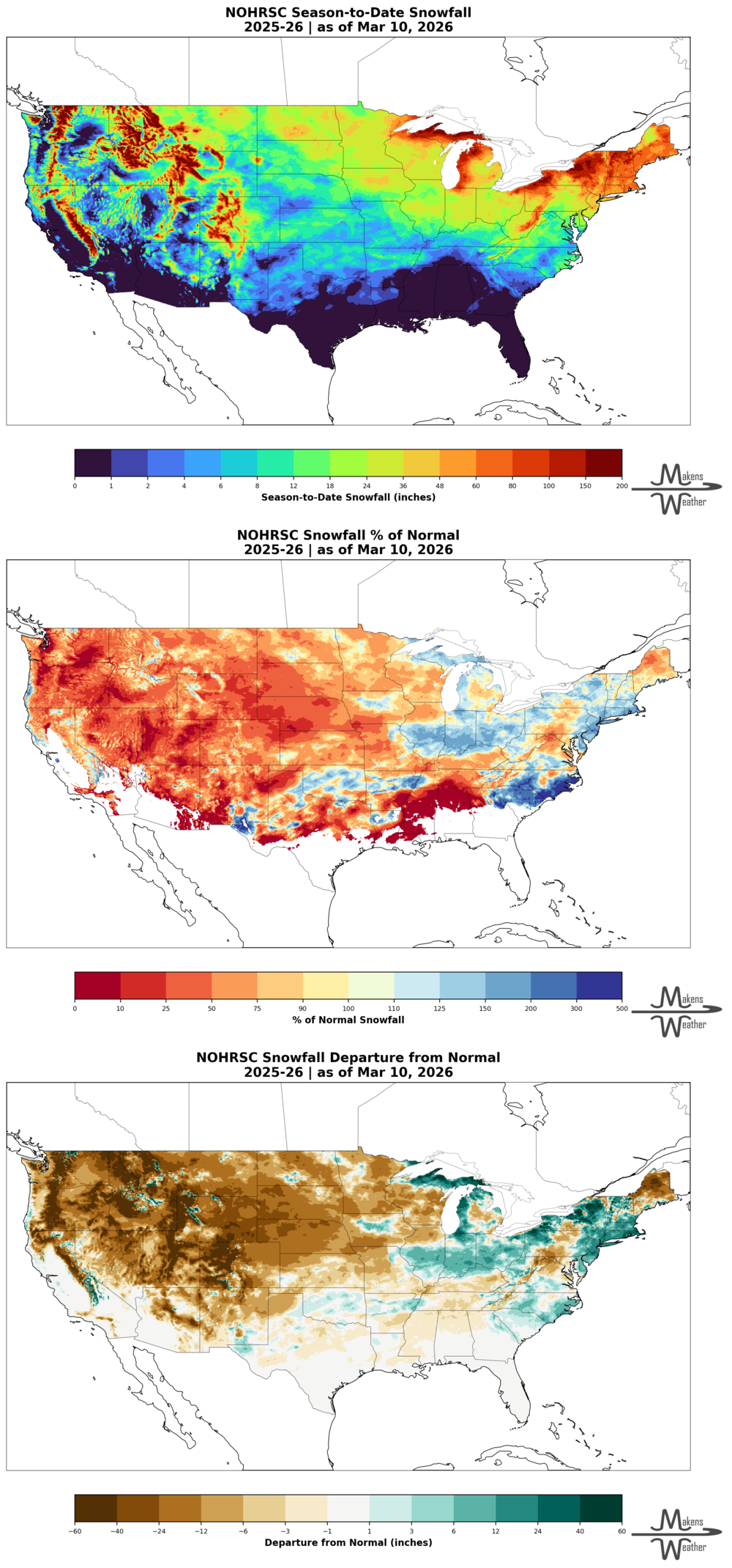
Conditions have also worsened across the Midwest, with drought expanding west into the Central Great Plains and parts of the Rockies after a very dry winter. In the Western U.S., below-normal snowpack remains a major concern heading into spring.
DIG DEEPER: U.S. SEASON SNOWFALL TO DATE (THIS DATA DOMAIN FOR THE CONTIGUOUS U.S. ONLY AT THIS TIME)
ARE YOU CIRRUS?!
Today in weather history:
The 1891 Great Blizzard struck southern England and Wales from March 9 through 13. 220 people were reported dead, and 65 ships floundered in the English Channel. 6000 sheep perished. Countless trees were uprooted and trains were buried in snow. Up to a foot of snow and snowdrifts of 11.5 feet high were recorded at London and Dartmouth.
A drawn-out storm pattern will keep much of the country active through the first week of April. A slow-moving front stretching from the Great Lakes into the Plains will separate late-season snow and ice to the north from heavy rain and severe thunderstorms to the south. The setup brings the greatest impacts to parts of the Midwest, Ohio Valley, Southern Plains, Mississippi Valley, and eventually the East Coast, while the West sees mountain snow and then a warming trend heading into the weekend.