


Weekly Weather Watch: Tuesday, March 3rd, 2026
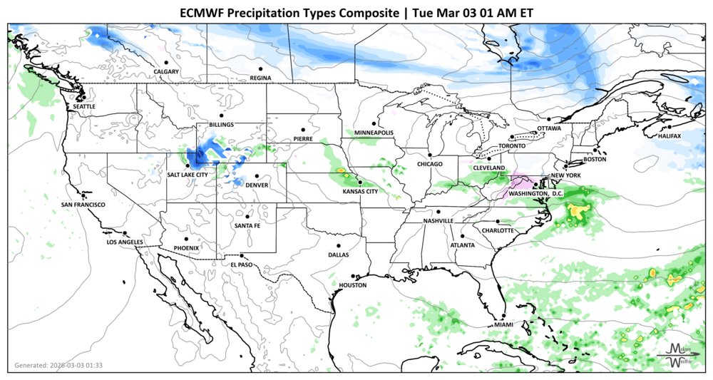
An active early-March pattern will bring slick travel to parts of the Northeast, rounds of strong to severe storms from the southern Plains to the Midwest, and a growing flood threat across the south-central U.S. late this week into the weekend. Meanwhile, much of the central and eastern U.S. turns unseasonably warm, with some areas flirting with daily records. A system crossing Canada will begin near Alberta and Saskatchewan with some moisture, but drop significant precipitation totals on Quebec and the Maritimes later this week. Moments of significant wind (chinook) will hit those along and east of the Rockies.
Unlock the Makens Weather Advantage ☀️📊
Your membership includes:
✔️ Real-time dashboard with the latest weather observations and long-range projections
✔️ Monthly-lead forecasts to plan weeks ahead
✔️ Discounts on personalized consultations for ag, energy, or risk planning
All built for decision-makers who need weather insight, not just data.
🎯 Join now and put the forecast to work for you.
📈 The latest outlooks and conditions - track it 👉 Join Now to Access the Dashboard
HEADLINERS (MAPS ARE BEING DEVELOPED TO INCLUDE CANADA AND MEXICO IN FUTURE VERSIONS):
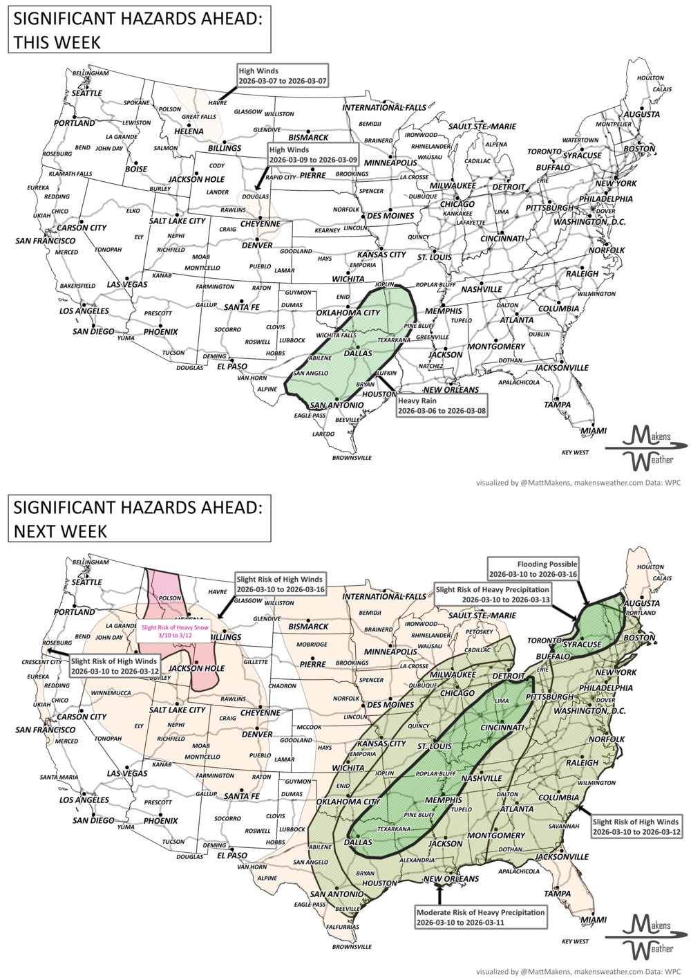
what to watch
Tuesday – Wednesday:
Light snow, sleet, and freezing rain from the central Appalachians into the Mid-Atlantic and southern New England, leading to slick roads.
Showers and thunderstorms from the Texas Panhandle to central Missouri and into the Ohio Valley, with isolated severe storms and locally heavy rain.
Wednesday – Thursday:
Increasing risk of severe thunderstorms from North Texas to the Ozarks.
Additional rain spreads across the Midwest, Mid-Atlantic, and Northeast.
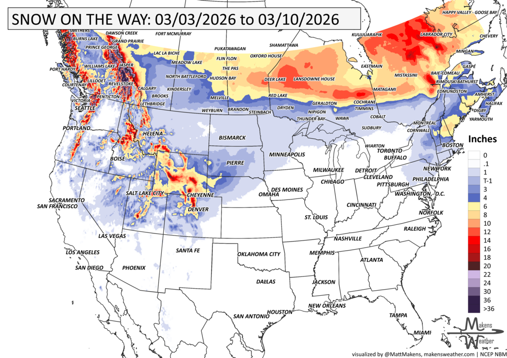
Gusty winds and mountain snow arrive in the Pacific Northwest, spreading into the Intermountain West and Rockies.
Thursday:
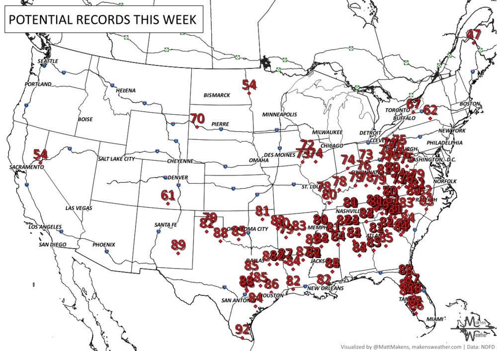
Record-challenging warmth expands from the southern Plains into the Southeast and toward the Ohio Valley and Mid-Atlantic.
Highs in the 70s and 80s become widespread across the central and southern U.S.
Friday – Sunday:
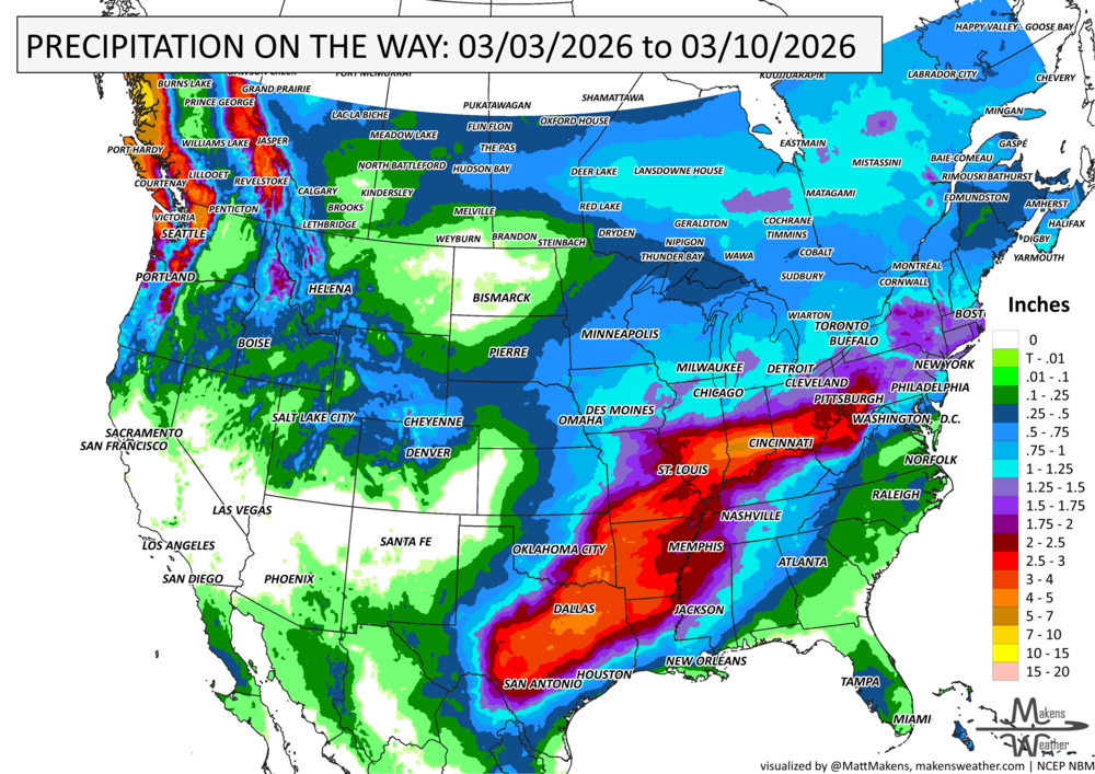
Heavy rain and flooding potential increase across the south-central Plains into the Mid-Mississippi Valley.
Repeated rounds of thunderstorms, some severe, are possible from Texas into Arkansas, Oklahoma, and nearby states.
Lingering rain in the Northeast, with some wintry weather possible across northern interior areas.
Early Next Week:
Continued wet pattern across parts of the central U.S.
Well-above-average temperatures persist across much of the East, with daily records possible.
IN THE GAUGES, PRECIPITATION THROUGH THE 10th:
GRAB A RULER, SNOWFALL THROUGH THE 10th:
RECORDS MADE TO BE BROKEN, DAILY HIGHS (RED) | DAILY LOWS (BLUE):
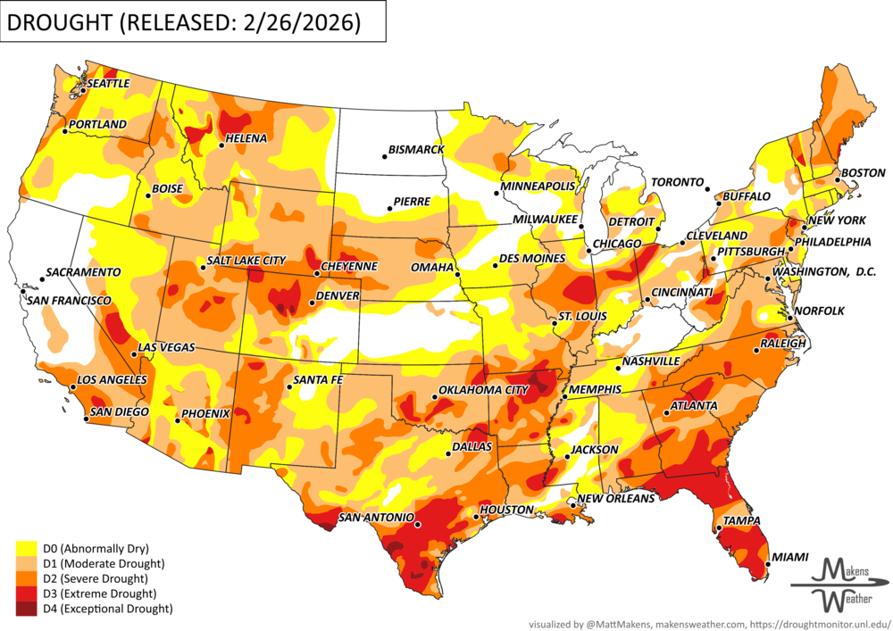
UN-DROUGHTABLY DRY:
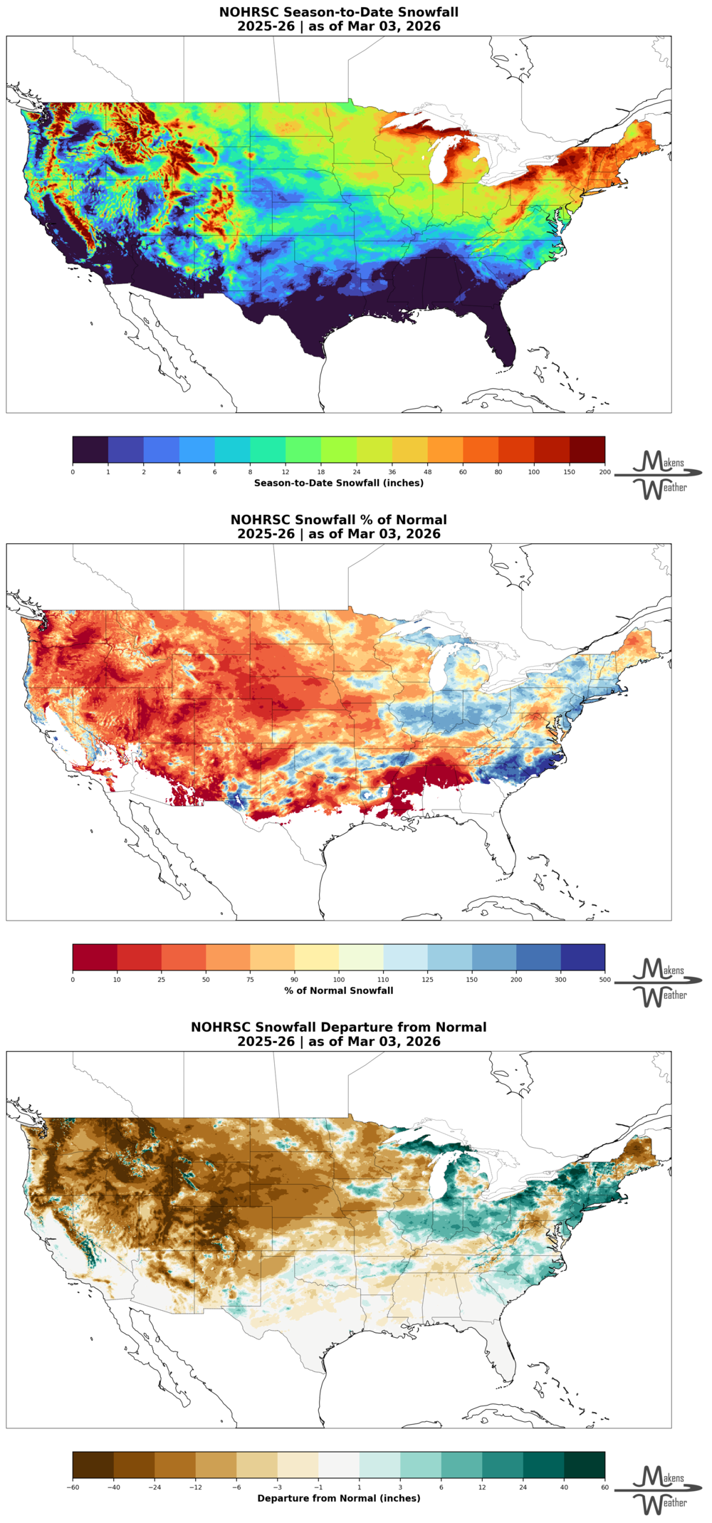
Stormy weather brought a boost to the West’s mountain snowpack, adding about 6 inches of snow-water equivalent to the Sierra Nevada. However, heavy snowfall, up to 8 feet in some areas, caused travel disruptions and led to a deadly avalanche near Lake Tahoe.
At the same time, record warmth and strong winds fueled major wildfires across the central and southern High Plains, including the Ranger Road Fire in Oklahoma and Kansas, which burned more than 280,000 acres and caused livestock and property losses.
Meanwhile, multiple storms impacted the eastern U.S., ending with a powerful late-winter blizzard on February 22–23 that dropped over a foot of snow from Philadelphia to Boston and nearly 38 inches in Providence, Rhode Island. Just days earlier, an early-season severe weather outbreak produced up to a dozen tornadoes in Illinois and Indiana.
DIG DEEPER: U.S. SEASON SNOWFALL TO DATE (THIS DATA DOMAIN FOR THE CONTIGUOUS U.S. ONLY AT THIS TIME)
ARE YOU CIRRUS?!
Today in weather history:
1841: President William Henry Harrison delivered a 100-minute inaugural address in freezing temperatures, while refusing to wear a coat or hat. He came down with pneumonia and died on April 4th, only 32 days into his presidency.
1966: Jackson, MS was heavily damaged by a half-mile wide F5
1966: The blizzard began late on March 2 in the west and moved very slowly across the state, reaching the extreme east on the 4th and continuing into the 5th. Snow depths ranged from 2 to 4 inches in southeast South Dakota to nearly 3 feet in north-central South Dakota. Winds of 40 to 55 mph with gusts to 70 mph caused widespread blowing snow and near-zero visibilities during the storm. Drifts up to 30 feet were reported in sheltered areas with bare open fields. The storm caused massive livestock losses. Estimated losses were 50,000 cattle, 46,000 sheep, and 1800 hogs. The most substantial losses were in the central and north-central parts of the state. The heavy snow also collapsed many structures. The storm directly caused three deaths due to exposure, and the storm indirectly caused three: 2 due to heart attacks and one by asphyxiation. The blizzard was rated as one of the most severe that has been experienced in South Dakota. Many roads were blocked for days, and many schools and businesses closed.
1989: A massive dust storm lowered visibility to zero along I-10 in Cochise County, AZ. Chain-reaction accidents involved 25 cars. Two motorists were killed.
2007: An area of low pressure moved slowly northeast across the central and northern plains, bringing widespread snowfall and intense winds. The combination of the falling snow and the existing snow cover resulted in blizzard conditions with visibilities to zero at times. This blizzard event was part of the same upper-level low-pressure trough that brought the heavy snowfall to the area on February 28th. Additional snowfall occurred across the region on March 1st and 2nd as a large area of snow wrapped in from the east. Widespread blizzard conditions developed by noon on March 2nd and continued into the early morning of the 3rd. Snowfall amounts, including the snow on February 28th, ranged from 2 inches to 22 inches across central and northeast South Dakota. The heaviest snowfall amounts were across northeastern South Dakota, where total snow depths were in the 25 to 30-inch range. Northwest winds of 30 to 45 mph with gusts near 60 mph brought zero visibilities across the area, creating large snowdrifts. Schools, businesses, airports, roads, and interstates were closed for up to two days. Travel was not advised across the area. Also, many cars were ditched, along with several accidents. Many travelers were stranded, and several shelters were opened. The Emergency Operations Center was activated in Pierre, and the Governor declared the blizzard area a disaster. Some of the most significant snowfall amounts over the 3 days included 11 inches at Andover, Hosmer, and Redfield, 12 inches at Webster, 13 inches at Miller, 14 inches at Victor, Groton, and Clark, 15 inches at Castlewood and Summit, 16 inches at Watertown and Roy Lake, 19 inches at Sisseton, 20 inches at Milbank, 21 inches at Bryant, and 22 inches at Clear Lake.
A drawn-out storm pattern will keep much of the country active through the first week of April. A slow-moving front stretching from the Great Lakes into the Plains will separate late-season snow and ice to the north from heavy rain and severe thunderstorms to the south. The setup brings the greatest impacts to parts of the Midwest, Ohio Valley, Southern Plains, Mississippi Valley, and eventually the East Coast, while the West sees mountain snow and then a warming trend heading into the weekend.