


Weekly Weather Watch: Tuesday, May 19th, 2026
There is A LOT of El Niño discussion happening right now. Although “Super” isn’t an official term, the potential for becoming one of the strongest events on record has been dubbed the “Super El Niño” buzz. The problem is that the atmosphere has yet to “couple” with the warming ocean conditions in order to create an El Niño pattern as of now, but that may shift in the coming weeks. I’ve broken down the latest in this YouTube video (click here).
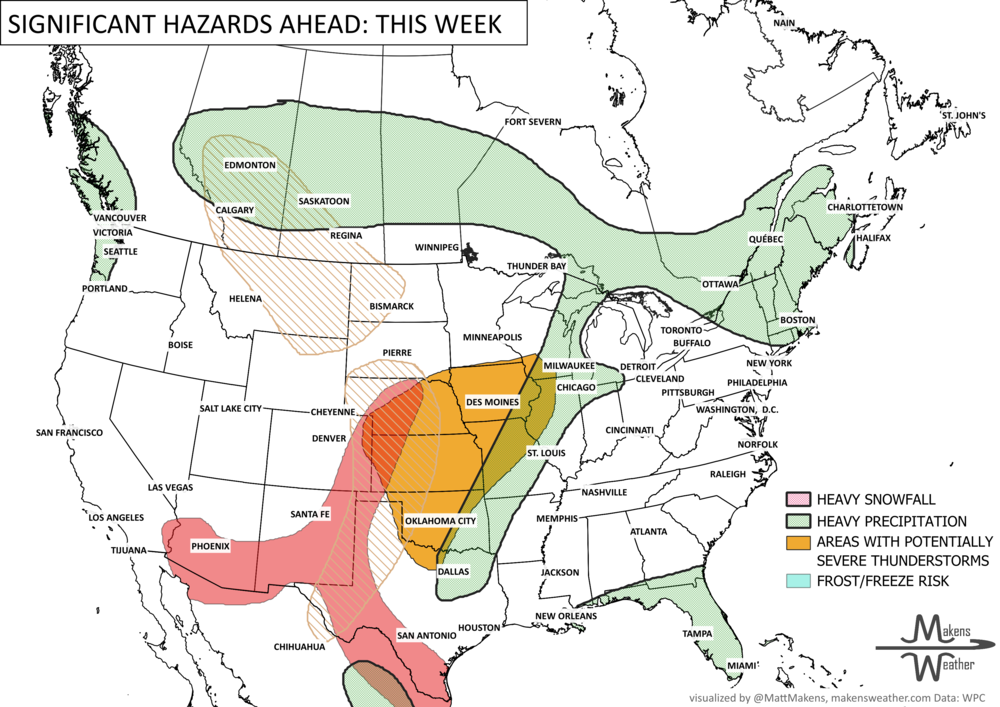
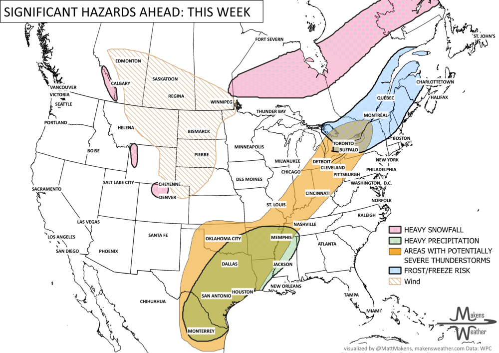
Now, onto this week’s highlights. A highly active weather pattern will dominate much of the country through the upcoming holiday weekend. Severe thunderstorms capable of damaging winds, large hail, and flash flooding will stretch from the southern Plains into the Midwest and Ohio Valley, while repeated rounds of heavy rain raise flooding concerns across Texas and portions of the south-central U.S. At the same time, an early-season heatwave will push temperatures near or above records across the eastern U.S., especially along the I-95 corridor. Fire danger also remains elevated across parts of the Southwest and Southern High Plains due to gusty winds and dry conditions. A late-season frost/freeze is coming to eastern Canada and the Northeast U.S.; the heavy snowfall will stay in Ontario to Quebec.
BRAND NEW PRODUCT☀️📊
Know What's Coming — For Your Exact Location
Most seasonal outlooks give you a broad regional brushstroke. The Makens Weather Seasonal Forecast App gives you a point forecast for your location — temperature and precipitation outlooks for the next six months, updated every morning.
Here's what you get as a member:
Your address, not a region: Enter your location once. Every month, the latest consensus forecast is waiting for you.
Weeks 1–4 near-term: Refreshes daily, so short-range planning and seasonal planning live in the same place.
Not just the mean: Charts show the full model spread so you can see how confident the ensemble is, not just which direction it's leaning.
Probability metrics: Know whether 60% or 90% of simulations favor above-normal temperatures. Confidence matters as much as the forecast itself.
If you're making decisions that depend on what the next few months look like — planting windows, input purchases, grazing plans, contract timing — this is the tool that bridges the gap between "what's the general trend" and "what should I actually expect at my operation."
📈 The latest weekly and monthly outlooks 👉 Join Now to Access
HEADLINERS:
Next 7 Days: Key Timing and Impacts
Tuesday: Severe thunderstorms erupt from Oklahoma and Texas into the Midwest and Ohio Valley with damaging winds, hail, and flash flooding possible. Heavy snow in Ontario.
Tuesday Night – Wednesday: Heavy rainfall intensifies across central and eastern Texas, where repeated thunderstorms may lead to localized flooding concerns. Heavy snow shifts out of Ontario into Quebec and weakens.
Wednesday: Record-challenging heat expands across the Mid-Atlantic, Northeast, and major cities along the I-95 corridor with widespread moderate to major HeatRisk levels.
Wednesday – Thursday: Cooler air gradually arrives across the eastern U.S. as a cold front pushes east, bringing scattered showers and thunderstorms.
Late Week: A stalled front across Texas keeps daily thunderstorm chances active with additional heavy rainfall possible.
Friday – Sunday: Multiple rounds of heavy rain and thunderstorms target central and east-central Texas into portions of the lower Mississippi and Ohio Valleys. Flooding concerns may increase heading into the weekend. Gustier winds for Alberta, Saskatchewan, Montana and the Dakotas.
Weekend: Cooler, cloudy conditions settle east of the Appalachians, while warm and humid weather persists farther south along the Gulf Coast.
Early Next Week: Another upper-level storm system approaches the Pacific Northwest, increasing rain chances across Washington and nearby areas.
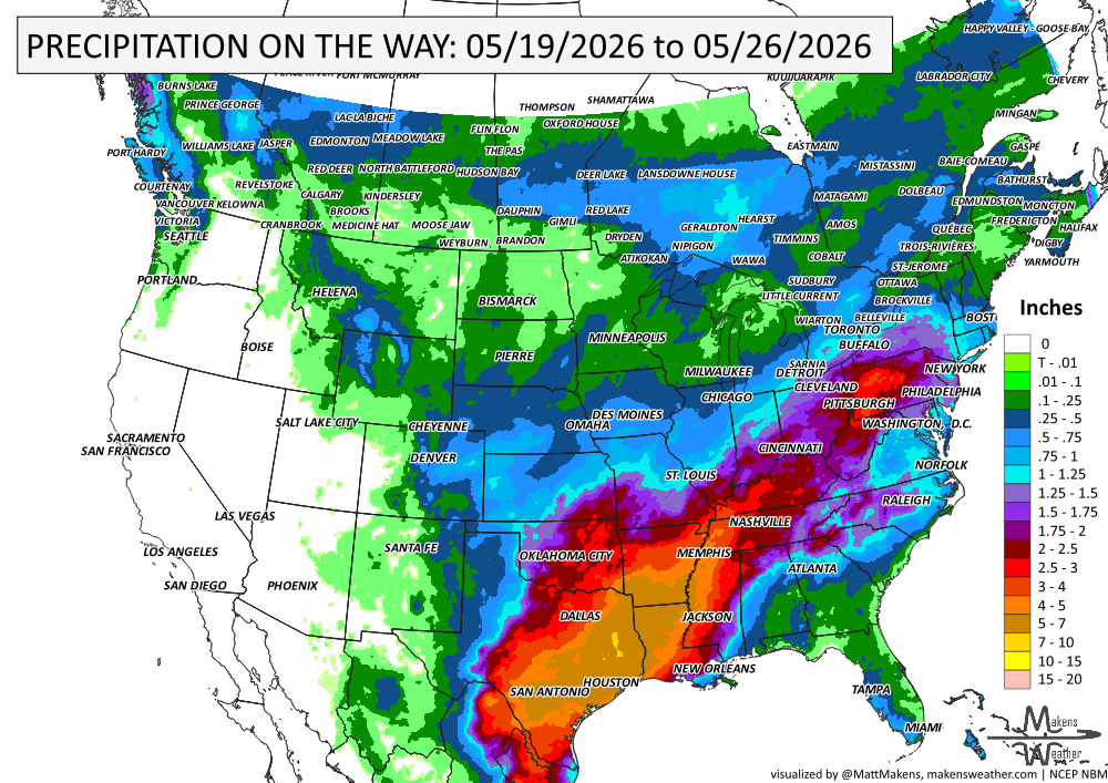
IN THE GAUGES, PRECIPITATION THROUGH THE 26TH:
Note: these projected totals are likely to be overdone in many areas because thunderstorms will be the primary source of rainfall, and we know they may be spread apart. So, these types of projections for thunderstorm areas reflect a potential rainfall total if you get the storms to pass over you. The actual observations will be more isolated totals of these magnitudes.
GRAB A RULER, SNOWFALL THROUGH THE 26TH:

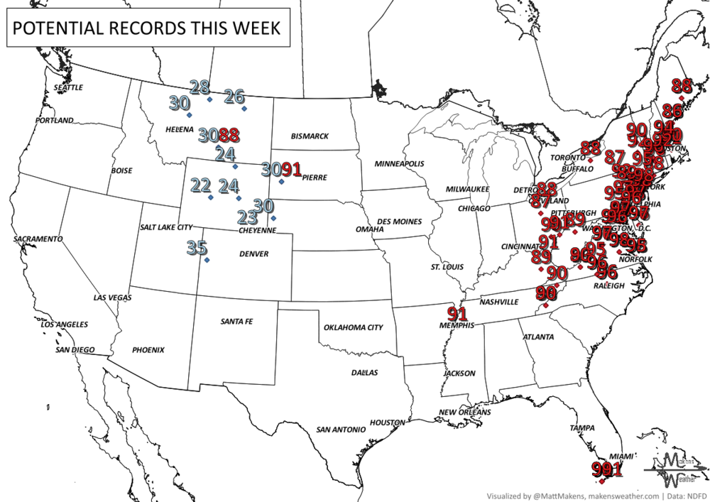
RECORDS MADE TO BE BROKEN, DAILY HIGHS (RED) | DAILY LOWS (BLUE):
Check out Rapid City, South Dakota, which will go from a record low to a record high; quite the temperature swing is expected this week.
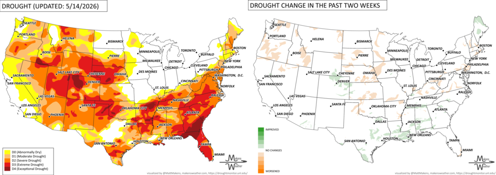
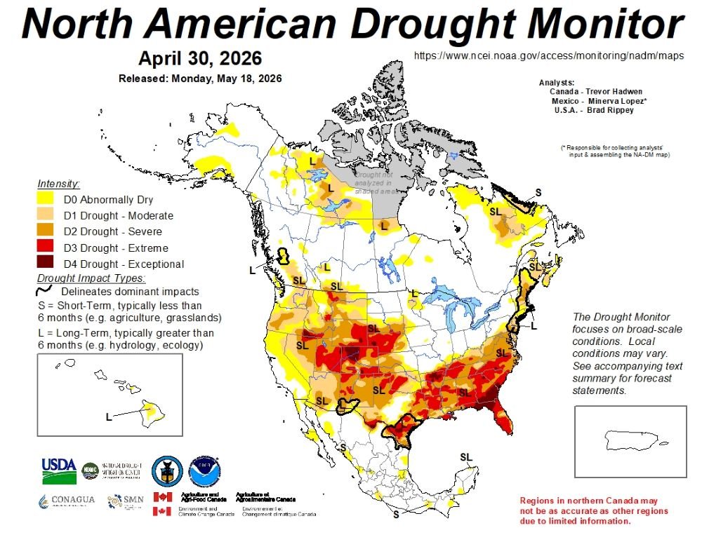
UN-DROUGHTABLY DRY:
Heavy rain soaked parts of the South and Gulf Coast this week, especially Louisiana, Mississippi, and Alabama, while much of the West remained very dry with elevated fire danger. Temperatures also split sharply nationwide, with intense heat across the West and South Texas, while the Northern Plains and Upper Midwest stayed much cooler than normal. - https://droughtmonitor.unl.edu/
ARE YOU CIRRUS?!
Today in weather history:
1990 Thirteen inches of rain fell in 9 hours at Hot Springs, AZ, resulting in a devastating flood. The 500-foot Carpenter Dam Bridge across Lake Catherine was completely washed away. Two waves of water, 4 to 6 feet deep, flooded stores along Central Avenue.
1979 At the Memorial Golf tournament in Dublin, OH, Tom Watson shot a remarkable 3-under-par 69 on one of the most miserable days ever at a PGA golf event. The temperature never exceeded 35 degrees, and the wind never fell below 20 mph. The rain came in horizontally all day long. No other player broke par that day, and 42 of the 105 starters didn't even break 80.
1960 Nearly 50 farms were devastated by a powerful tornado in northeast Kansas. The damage may have been of F5 intensity.
An active and impactful weather pattern is setting up across much of North America through next week. Multiple rounds of severe thunderstorms are expected from the eastern Canadian Prairies, U.S. Plains into the Mississippi Valley, bringing the risk of damaging winds, large hail, and tornadoes. Heavy rainfall may lead to localized flooding from the Northern Plains to the Southeast, while wildfire concerns continue across the Four Corners region. At the same time, summer heat is building, with the East experiencing its hottest temperatures of the season late this week before above-average warmth expands westward during the weekend.