


Weekly Weather Watch: Tuesday, May 26th, 2026
Sea surface temperatures in the region we focus on for El Niño have warmed this week to an average of +1°C (1.8°F), the threshold for a moderate El Niño, and continue to warm. These ocean surface conditions continue developing an El Niño at a pace similar to 1997’s event.
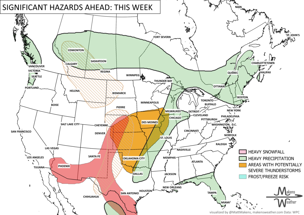
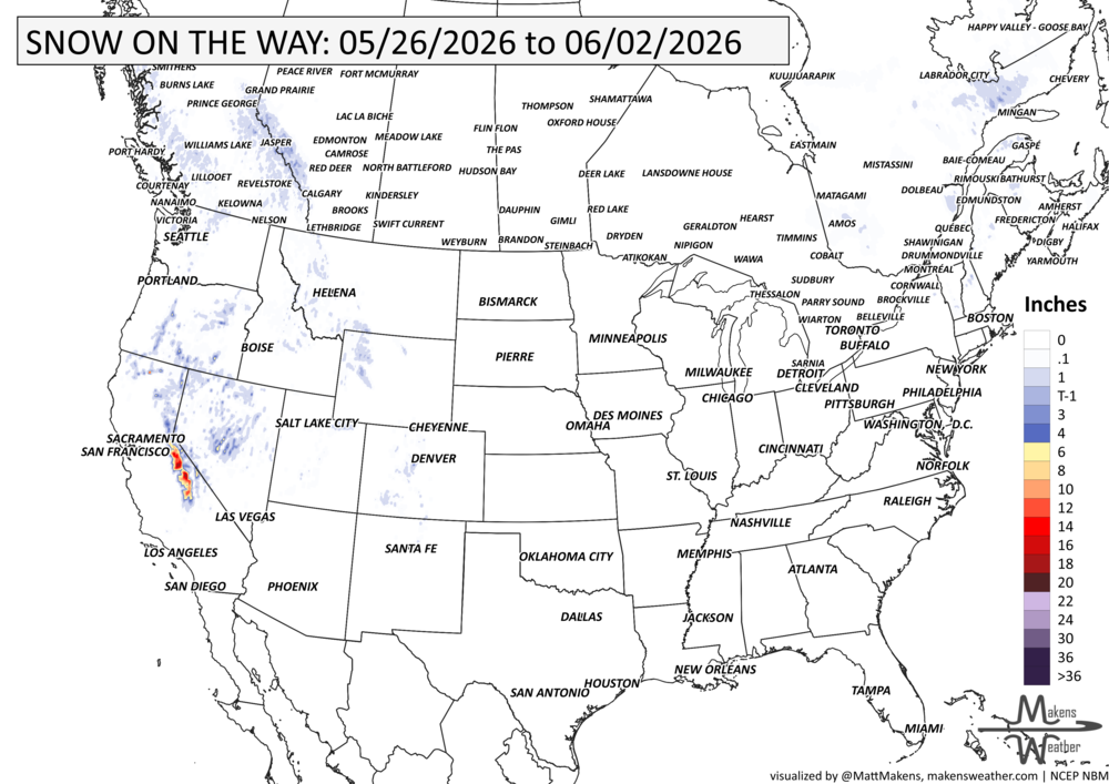
A very active late-May weather pattern is setting up across the United States this week. Repeated rounds of thunderstorms will stretch from Texas to the Mid-Atlantic and Southeast, bringing localized flash flooding and a few severe storms through the weekend. At the same time, the West stays cool and unsettled with mountain snow and scattered thunderstorms, while summerlike heat intensifies across the Northern Plains and Upper Midwest with temperatures running well above average. Heavy precipitation in Alberta’s mountains will attempt to spread eastward through Alberta into Western Saskatchewan this weekend.
BRAND NEW PRODUCT☀️📊
Know What's Coming — For Your Exact Location
Most seasonal outlooks give you a broad regional brushstroke. The Makens Weather Seasonal Forecast App gives you a point forecast for your location — temperature and precipitation outlooks for the next six months, updated every morning.
Your address, not a region: Enter your location once. Every month, the latest consensus forecast is waiting for you.
Weeks 1–4 near-term: Refreshes daily, so short-range planning and seasonal planning live in the same place.
Not just the mean: Charts show the full model spread so you can see how confident the ensemble is, not just which direction it's leaning.
Probability metrics: Know whether 60% or 90% of simulations favor above-normal temperatures. Confidence matters as much as the forecast itself.
If you're making decisions that depend on what the next few months look like — planting windows, input purchases, grazing plans, contract timing — this is the tool that bridges the gap between "what's the general trend" and "what should I actually expect at my operation."
📈 The latest weekly and monthly outlooks 👉 Join Now to Access
HEADLINERS:

Next 7 Days: Key Timing and Impacts
Tuesday
Texas to the central Gulf Coast faces widespread thunderstorms with localized flash flooding concerns.
Severe storms are possible across west and southwest Texas with damaging winds, hail, and isolated tornadoes.
Critical fire weather conditions continue across parts of Oregon and Nevada due to gusty winds and low humidity.
Temperatures surge into the 90s across portions of the Northern Plains and Upper Midwest.
Wednesday
Heavy rain shifts into the Ohio Valley, Louisiana, and eastern Texas with additional flash flooding concerns.
Thunderstorms continue from the Deep South into the southern Mid-Atlantic.
Cooler, unsettled weather spreads across the Great Basin and Intermountain West with scattered mountain thunderstorms.
Heat remains intense across Montana, the Dakotas, and Minnesota.
Gusty winds in southern Saskatchewan are expected to continue periodically through the week.
Thursday
Daily thunderstorms continue across the Southeast and Florida with isolated flooding concerns lingering.
Snow showers continue at the highest elevations of the Sierra Nevada and Cascades.
Cooler-than-normal temperatures expand across California, Nevada, Utah, and Arizona.
Warmth begins spreading eastward into the Midwest and Ohio Valley.
Friday
A broad area of showers and thunderstorms develops from the lower Mississippi Valley into the Southeast.
Flash flooding concerns persist where repeated heavy rain occurs.
Rain and thunderstorms increase across the Northern Rockies and Central High Plains.
The Northeast remains cool with periods of rain.
Saturday
Storm activity focuses along a frontal boundary across the Southeast.
Tropical moisture keeps a wet pattern going across Florida with localized urban flooding possible.
Thunderstorm chances begin increasing again across Texas.
Temperatures remain above normal across much of the north-central U.S.
Areas of heavier precipitation from Alberta into western Saskatchewan.
Sunday
Scattered thunderstorms continue across Texas, the southern Plains, and portions of the Deep South.
Rain chances linger across the Pacific Northwest and Northern Rockies.
Warm temperatures continue across the Northern Plains while cooler air persists in the Northeast.
Areas of heavier precipitation from Alberta into western Saskatchewan.
Monday
The active storm pattern continues across the southern Plains and Gulf Coast.
Additional rounds of thunderstorms may bring localized flooding concerns from Texas to the Southeast.
Temperatures trend closer to seasonal averages across portions of the West, while warmth lingers across the central U.S.
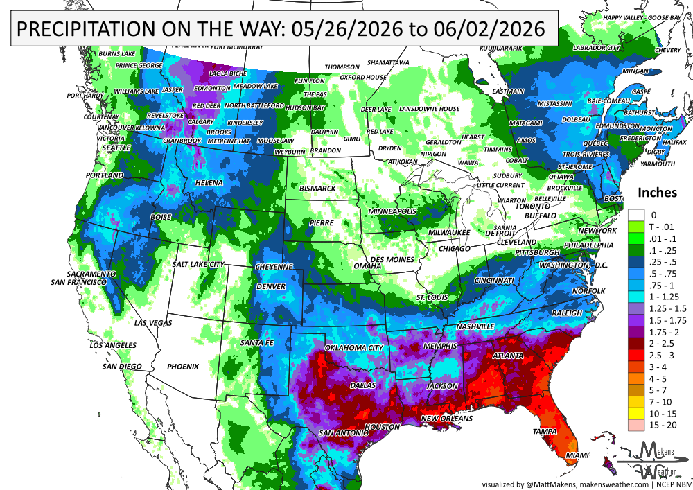
IN THE GAUGES, PRECIPITATION THROUGH THE 2ND:
Note: these projected totals are likely to be overdone in many areas because thunderstorms will be the primary source of rainfall, and we know they may be spread apart. So, these types of projections for thunderstorm areas reflect a potential rainfall total if you get the storms to pass over you. The actual observations will be more isolated totals of these magnitudes. I will not be surprised if we see the heavier rainfall totals from Texas and Oklahoma expand a bit northward into scattered parts of Kansas, compared to what is shown here.
GRAB A RULER, SNOWFALL THROUGH THE 2nd:
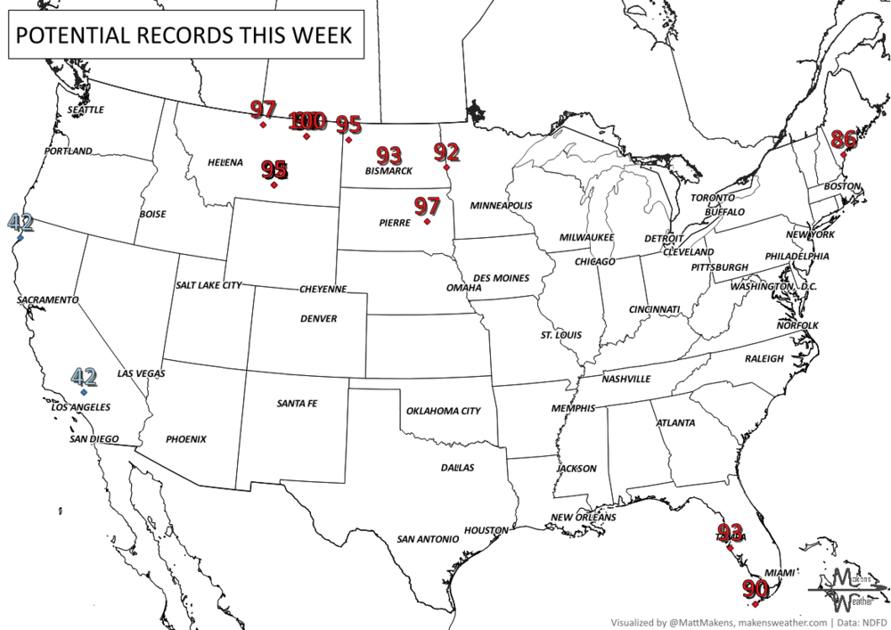
RECORDS MADE TO BE BROKEN, DAILY HIGHS (RED) | DAILY LOWS (BLUE):
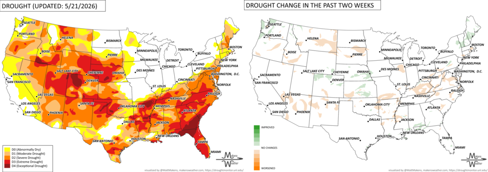
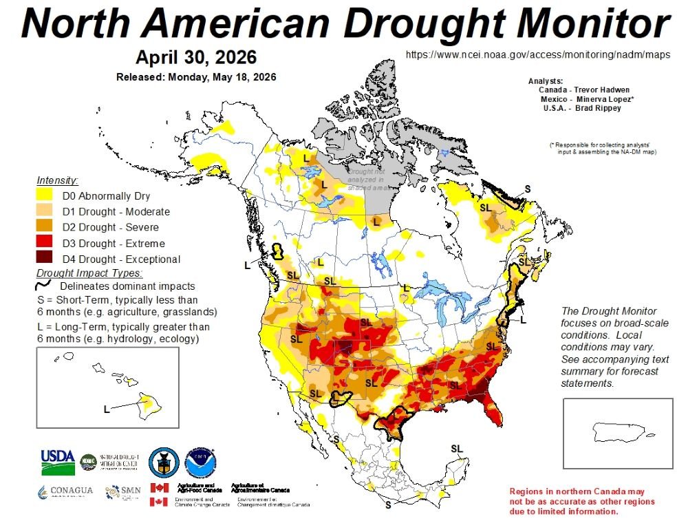
UN-DROUGHTABLY DRY:
A highly amplified weather pattern brought major temperature swings and active severe weather across the U.S. this week. Early on, unusually cold air spread across the Northern Plains, Upper Midwest, and Northeast, while the Southwest and South Texas saw temperatures up to 15 degrees above normal. By late week, the warmth expanded eastward, bringing early-season heat to the Ohio Valley and Mid-Atlantic. Meanwhile, heavy rain and severe thunderstorms impacted the central Gulf Coast and Great Plains, producing flooding, damaging winds, large hail, and tornadoes. In contrast, very dry conditions persisted across the western U.S., increasing wildfire concerns. - https://droughtmonitor.unl.edu/
ARE YOU CIRRUS?!
Today in weather history:
1984 Thunderstorms dropped 6 to 13 inches of rain at Tulsa, OK, in 6 hours. The flooding claimed 14 lives and caused $90 million in property damage. 4600 cars, 743 houses, and 387 apartments were destroyed or severely damaged in the flood.
1967 A slow-moving nor'easter battered New England with high winds, heavy rain, and record late-season snow. Winds 70 to 90 mph in gusts occurred along the coast. Over 7 inches of rain fell at Nantucket, MS, with 6.57 inches falling in 24 hours to set a new 24-hour rainfall record. 24.9 inches of snow fell at Mount Washington, NH, to set a new May snowfall record.
An active and impactful weather pattern is setting up across much of North America through next week. Multiple rounds of severe thunderstorms are expected from the eastern Canadian Prairies, U.S. Plains into the Mississippi Valley, bringing the risk of damaging winds, large hail, and tornadoes. Heavy rainfall may lead to localized flooding from the Northern Plains to the Southeast, while wildfire concerns continue across the Four Corners region. At the same time, summer heat is building, with the East experiencing its hottest temperatures of the season late this week before above-average warmth expands westward during the weekend.