


Weekly Weather Watch: Tuesday, February 24th, 2026
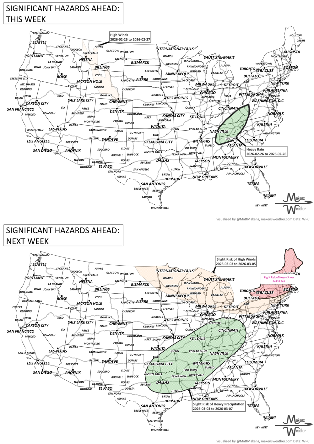
A busy stretch of weather is underway across the country. Critical fire weather conditions are developing from southeast Colorado into the southern Plains and the Ozarks, while an atmospheric river targets northern California with heavy rain and flood potential. At the same time, a fast-moving clipper system is bringing heavy snow to the Great Lakes, followed by colder air for parts of the northern tier this weekend from Central and Western Canada into the Northern U.S.
Unlock the Makens Weather Advantage ☀️📊
Your membership includes:
✔️ Real-time dashboard with the latest weather observations and long-range projections
✔️ Monthly-lead forecasts to plan weeks ahead
✔️ Discounts on personalized consultations for ag, energy, or risk planning
All built for decision-makers who need weather insight, not just data.
🎯 Join now and put the forecast to work for you.
📈 The latest outlooks and conditions - track it 👉 Join Now to Access the Dashboard
HEADLINERS:
what to watch
Tuesday
Critical fire weather across southeast Colorado, western Kansas, Oklahoma, and the Texas Panhandle. Avoid outdoor burning.
Heavy rain develops in northern California, especially near the northern Sierra Nevada foothills.
Heavy snow spreads across the Great Lakes as a clipper system moves through. Snow advisories in place in southern Ontario, Newfoundland & Labrador.
Gusty winds linger across the Northeast as the departing Nor’easter pulls away.
Wednesday
Fire weather concerns continue from southeast Colorado into the southern Plains and Ozarks.
Snow showers taper across the Great Lakes, with lake-effect snow continuing downwind. Blowing snow advisory for southeastern Ontario.
Mountain snow continues in the Cascades and northern Rockies.
Temperatures begin moderating along the East Coast.
Thursday
The western storm system shifts southeast into the Plains.
Light wintry precipitation possible across portions of the northern Plains.
Thunderstorm chances increase across parts of the Southeast.
Cooler air lingers behind the system in the Great Lakes and Northeast.
Friday
Showers and thunderstorms develop across Florida, with periods of moderate to heavy rain.
Much above average warmth across the Southwest and into the central Plains.
A reinforcing clipper may bring light snow from Montana toward the Upper Midwest.
Saturday
Heavy rain continues at times across Florida, with localized flooding possible.
A strong Arctic front pushes across Western and Central Canada into the northern Plains.
Temperatures begin dropping sharply in North Dakota and Minnesota.
Sunday
Much colder air spreads across the northern tier and into parts of the Midwest.
Wind chills drop well below zero in portions of the northern Plains and Canadian Prairies.
Cooler air begins arriving in the Mid-Atlantic and Northeast.
Monday
Watching for a potential wintry mix from the mid-Mississippi Valley into the Mid-Atlantic and Northeast.
Snow, sleet, or freezing rain possible, placement and impacts still uncertain.
Warmer conditions persist across the Desert Southwest, with near-record warmth possible.
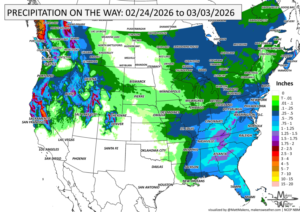
IN THE GAUGES, PRECIPITATION THROUGH THE 3RD:
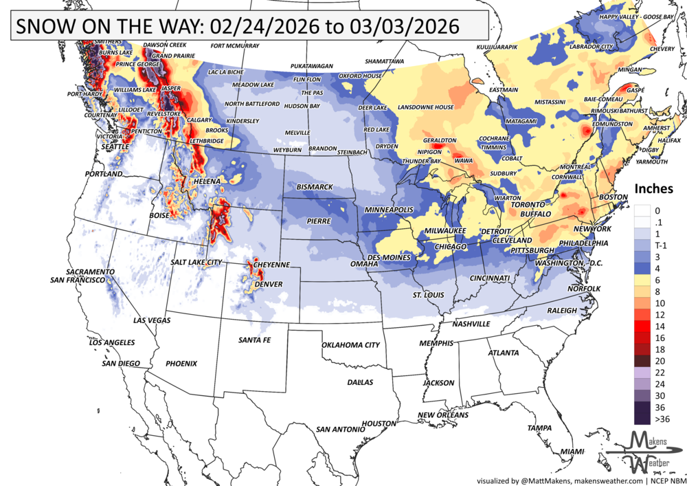
GRAB A RULER, SNOWFALL THROUGH THE 3RD:
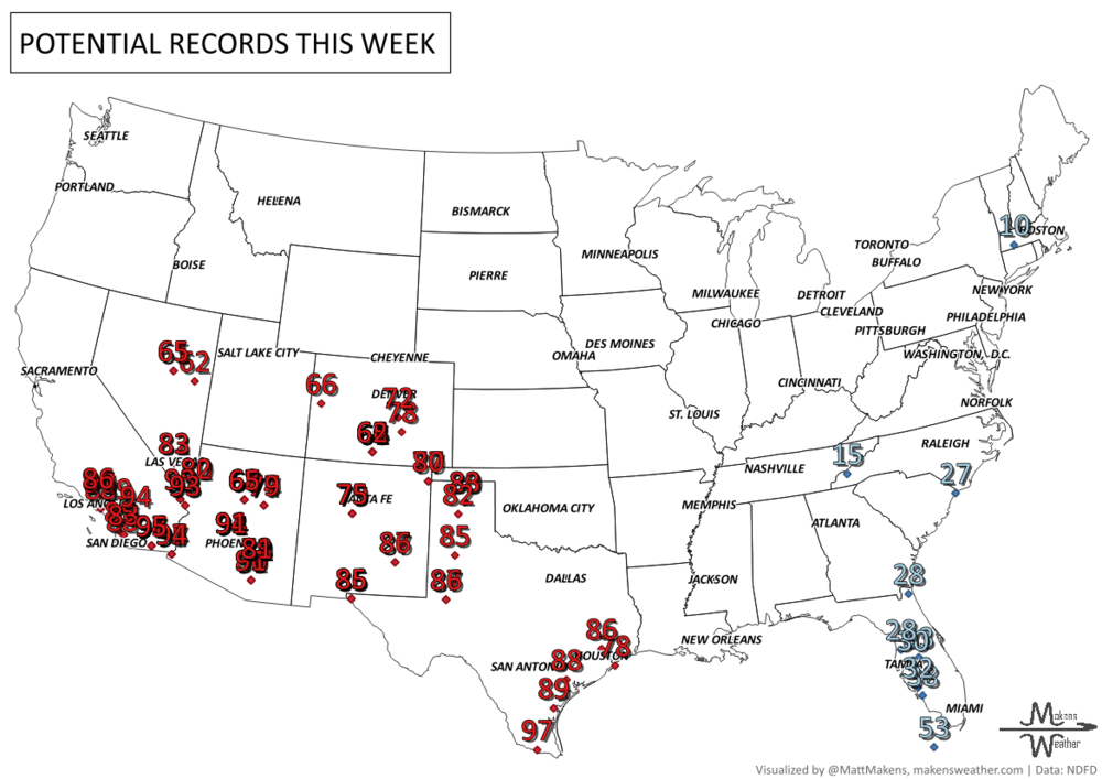
RECORDS MADE TO BE BROKEN, DAILY HIGHS (RED) | DAILY LOWS (BLUE):
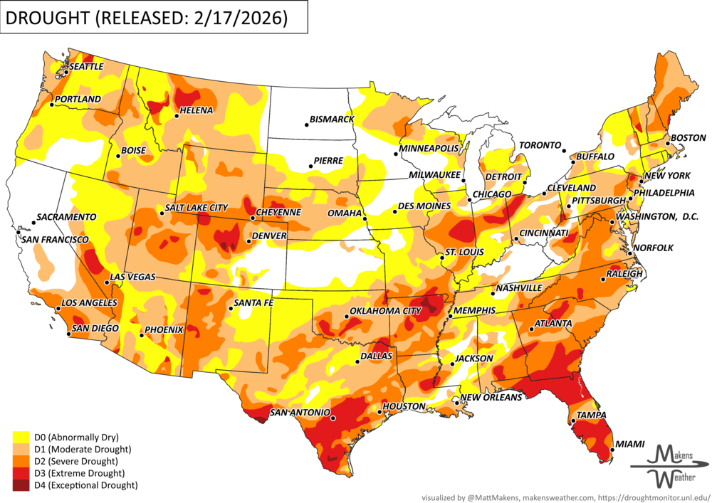
UN-DROUGHTABLY DRY:
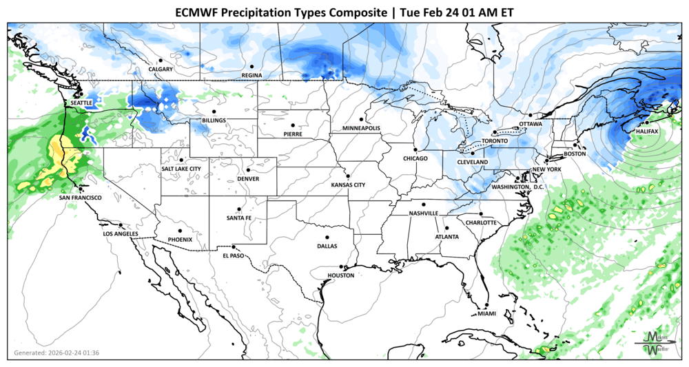
Heavy precipitation returned to the West Coast this past week, with the heaviest totals focused on California. Much of the state picked up over 1.5 inches of liquid, with isolated mountain areas nearing 10 inches. Several feet of snow fell in the Sierra Nevada, though snowpack remains below normal across much of the Cascades and central Rockies.
Farther east, moderate rainfall covered much of the Southeast, lower Ohio Valley, and mid-Atlantic, with heavier pockets in parts of the Great Plains and Florida Panhandle. Many areas of the High Plains and Northeast saw little precipitation.
Some drought improvements were noted in central Idaho, the southwestern High Plains, and parts of the Tennessee and Ohio Valleys, but overall deterioration outweighed improvement, especially across portions of the Eastern Seaboard, Deep South, Upper Midwest, and south Texas.
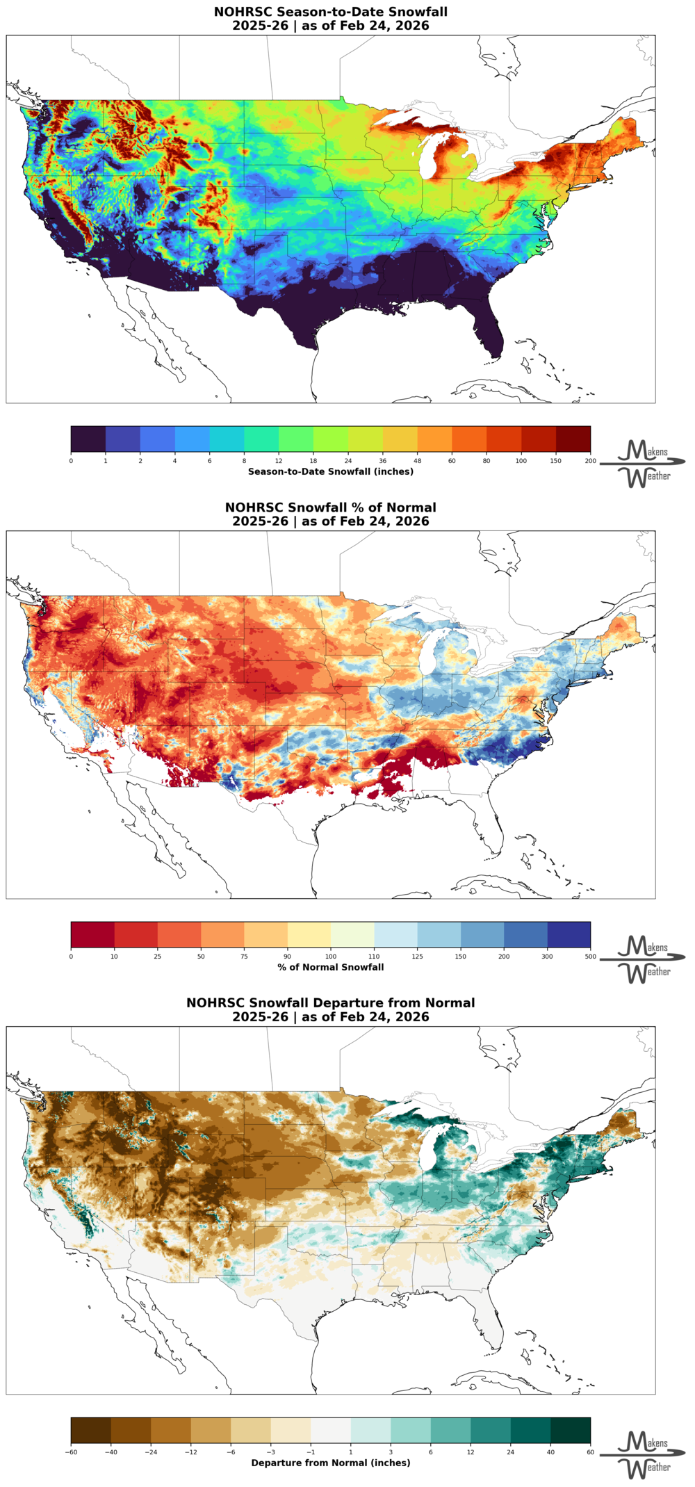
DIG DEEPER: U.S. SEASON SNOWFALL TO DATE
ARE YOU CIRRUS?!
Today in weather history:
1969: The famous "100-Hour Storm" began in Boston, MA. Snow often fell between early on the 25th and noon on the 28th. The 26.3 inches at Logan Airport is the 2nd most significant snowstorm in Boston's history. In addition, 77 inches fell at Pinkham Notch Base Station in New Hampshire, bringing their February total to 130 inches. Their snow cover on the 27th was 164 inches. Mt. Washington, NH, received 172.8 inches of snow in the month.
2001: Over a dozen tornadoes spawned in central and eastern Arkansas.
2007: An EF3 tornado struck Dumas, Arkansas, injuring 28. Seven other tornadoes hit southeast Arkansas on this day, thankfully no fatalities.
2016: A strong area of low pressure along with a cold front produced a severe weather outbreak from North Carolina to Pennsylvania. Not one but two rare February tornadoes occurred in central Virginia. The strongest tornado caused EF3 damage in Appomattox County.
A busy stretch of summer weather is underway. The greatest concern through midweek will be severe thunderstorms capable of damaging winds, large hail, isolated tornadoes, and flash flooding from the Dakotas into Minnesota and later the Upper Midwest. At the same time, dangerous heat continues across the Southeast, while a strengthening ridge will send temperatures soaring across the Northern Plains and Central U.S. heading into the weekend. Meanwhile, the Southwest monsoon will gradually become more active, bringing increasing rounds of afternoon and evening thunderstorms. In British Columbia and Quebec, smoke is causing or expected to cause poor air quality and reduced visibility.