Weekly Weather Watch: Monday, January 29th, 2024
Welcome to the Weekly Weather Watch, a summary of those weather events that will make headlines in the week ahead. HYPE, that’s what many of you will deal with this week, particularly in Colorado, where there’s potential for a heavy snowfall event this weekend. Enjoy the wide range of misinformation you’ll see on social media channels. I won’t step onto my soapbox this time, so let’s get to the data.
Strong LOW for the Central U.S. A strong storm system will develop over the Four Corners to the Plains later this week and dumps a lot of water on some folks in the Central U.S. The exact bullseye is to be determined, but the potential exists between Wyoming and Nebraska, south through Colorado, Kansas, and Missouri, and into Oklahoma and Texas to the Southeast. A pure early estimate is shown here and will change a bit this week as the system develops/evolves.
That’s quite a lot of water for some folks desperately needing it. For Eastern TX through the Southeast, additional flooding is on the way this week into next. Check out the West Coast, too. A strong Atmospheric River (AR) event will leave a foot of total water in many places. Additional flooding may be seen here, too.
If we take that total precipitation and look at the portion that is snow, we see that potential is limited to higher elevations; there’s not a lot of cold air to work with this time. I see a nice potential of heavy snowfall across most Rockies and Sierras - nice for our water resource folks. If you squint, yes, that’s a bullseye of heavy snowfall between Denver and Colorado Springs. Anyone traveling (cough cough, myself included) should take note of potential delays. For Colorado readers, we have the latest updates on the storm via Weather5280, your local source for weather details.
Again, the week's temperature impact isn’t extreme, so most of us can expect warmer-than-normal temperatures before dropping to near average by the weekend and early next week. The exception is Florida and the Southeast, where temperatures are cooler than average.
This week, the headlines will revolve around wet weather from California to the Southeast. For those in Colorado, I apologize on behalf of credible meteorologists for all the content that will come your way - some good, some clickbait drama. For members, your February monthly outlook will arrive in your inboxes this Thursday, the 1st. AJ was kind enough to give us his agricultural guidance for the month ahead as the weather’s impact varies across differing industries, which follows. Have a safe and Blessed week, -Matt.
CULTIVATOR’S CORNER: for the producers out there, here are a few things to consider for the month of February:
If you are a gardener, it's a good time to start seeds indoors for cool-season vegetables, such as lettuce, spinach, peas, and onions. You can also plant some herbs, such as parsley, cilantro, and mint, indoors or in a protected area outdoors.
If you are a turfgrass manager, it's time to plan pre-emergent herbicides application to prevent weed growth and prepare a holistic pest management strategy for the growing season to stay ahead.
If you are a farmer, February is a relatively slow month and provides good opportunities to catch up on equipment maintenance and strategic and financial planning for future endeavors
If you are a rancher, calving season is here! You're probably too busy to even read this blurb, so we wish you the best of luck this year.
Happy Trails,
AJ

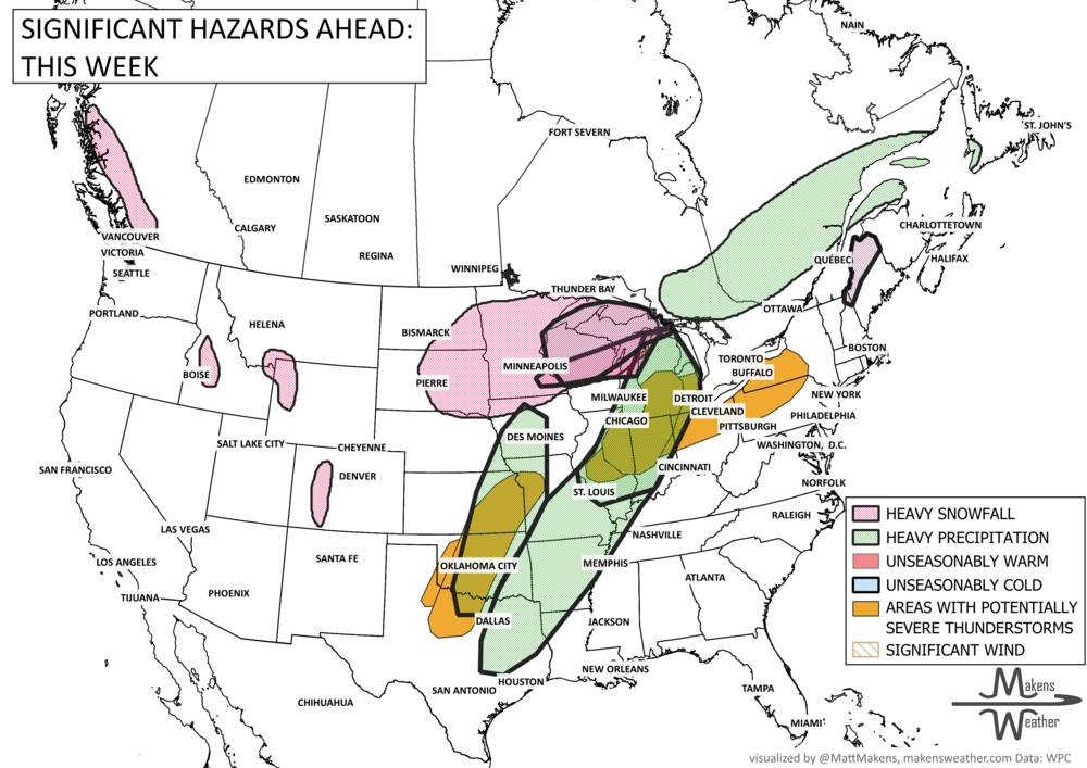
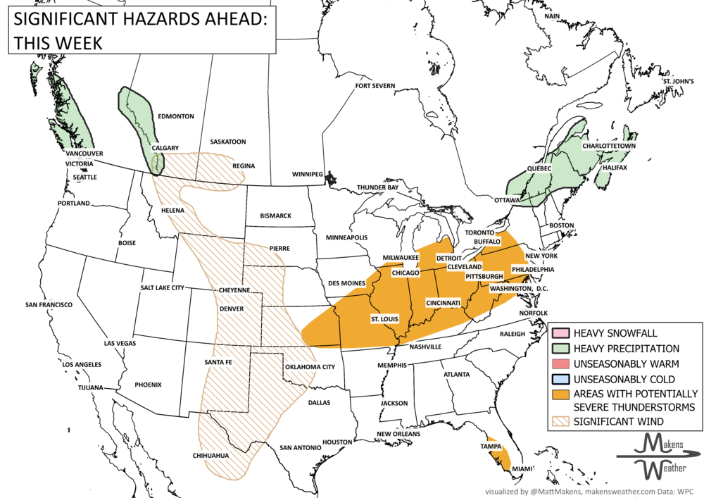
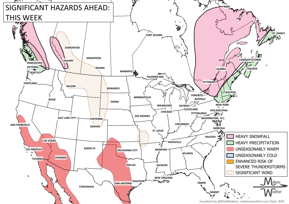
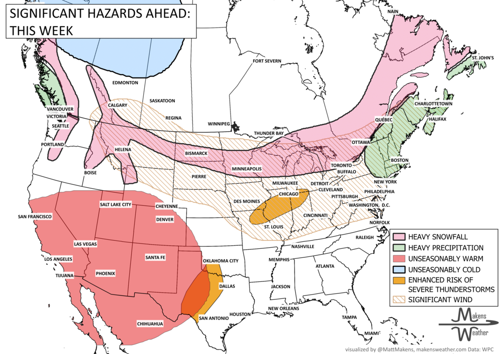
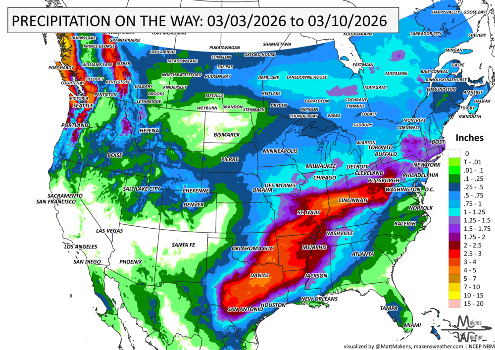


A drawn-out storm pattern will keep much of the country active through the first week of April. A slow-moving front stretching from the Great Lakes into the Plains will separate late-season snow and ice to the north from heavy rain and severe thunderstorms to the south. The setup brings the greatest impacts to parts of the Midwest, Ohio Valley, Southern Plains, Mississippi Valley, and eventually the East Coast, while the West sees mountain snow and then a warming trend heading into the weekend.