


Weekly Weather Watch: Tuesday, January 20th, 2026
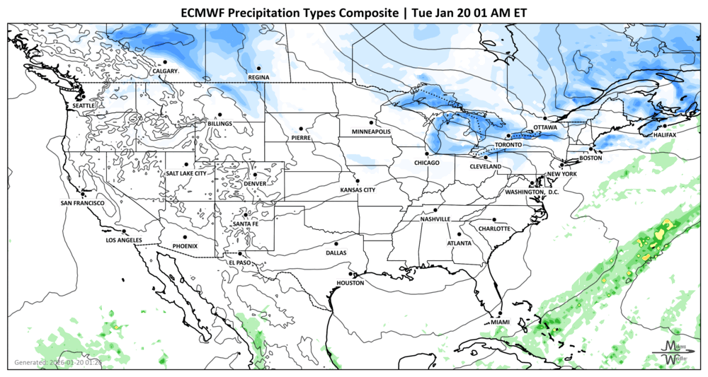
Dangerous weather for many - a very active winter pattern is unfolding across the U.S. Lake-effect snow continues around the Great Lakes through midweek, while dangerous Arctic cold grips much of the central and eastern states. Attention then shifts to Friday through the weekend, when a potentially high-impact winter storm could spread snow and ice from the Southern Plains into the Mid-Atlantic. Travel disruptions, power issues, and prolonged cold are all on the table. For Canada, dangerous cold, particularly for Central to Eastern Provinces. Snow squalls are possible in Alberta and Saskatchewan. For video updates on the pending ice and snowstorms, Brian and I have launched @realsnowbros on YouTube.
Unlock the Makens Weather Advantage ☀️📊
Your membership includes:
✔️ Real-time dashboard with the latest weather observations and long-range projections
✔️ Monthly-lead forecasts to plan weeks ahead
✔️ Discounts on personalized consultations for ag, energy, or risk planning
All built for decision-makers who need weather insight, not just data.
🎯 Join now and put the forecast to work for you.
📈 The latest outlooks and conditions - track it 👉 Join Now to Access the Dashboard
HEADLINERS:
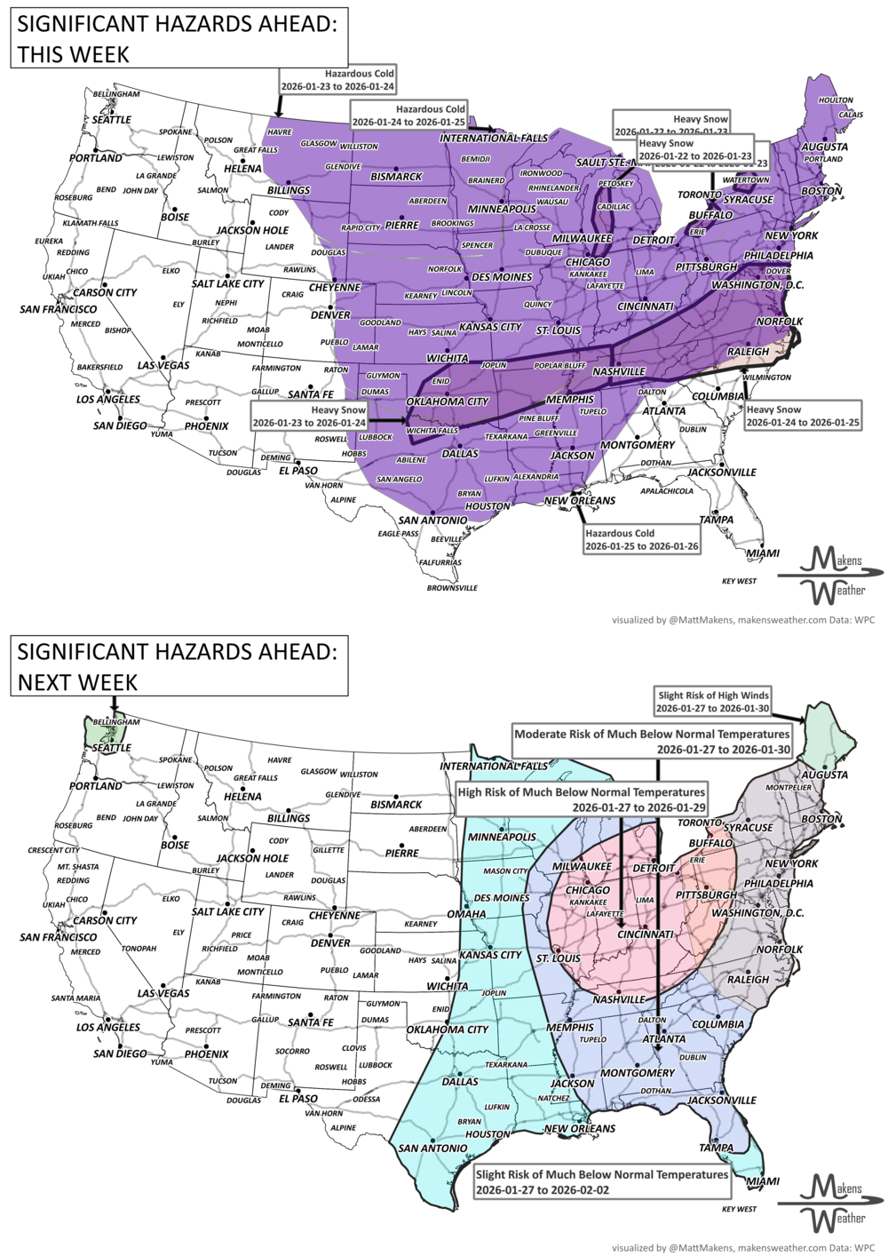
Weekly Timeline Snapshot
Tuesday–Wednesday
Persistent lake-effect snow downwind of the Great Lakes, especially near Lake Ontario
Very cold conditions from the Midwest into the Northeast
Freeze concerns continue across southern Georgia into central Florida
Snow squalls in Alberta and Saskatchewan
Continued cold for Ontario to the Maritimes
Wednesday–Thursday
Temperatures slowly rebound in parts of the East
Mostly quiet but mild weather holds across the Western U.S.
Light mountain snow possible in the Sierra Nevada
Continued cold for Ontario to the Maritimes
Friday
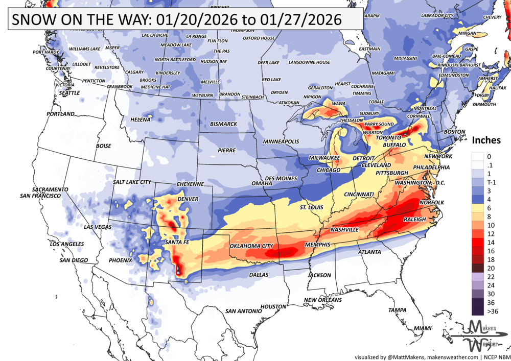
Major winter storm begins developing over the Southern Plains
Snow and ice expand into Texas, Oklahoma, and the Lower Mississippi Valley
Dangerous Arctic cold intensifies in the Northern Plains and Upper Midwest
Continued cold for Ontario to the Maritimes
Saturday
Widespread snow north of the storm track from the Tennessee Valley into the Ohio Valley
Freezing rain risk increases farther south into parts of the Deep South
Travel conditions deteriorate across a large portion of the central U.S.
Continued cold for Ontario to the Maritimes
Sunday
Storm shifts east with snow and ice impacting the Southeast and Mid-Atlantic
Cold air presses toward the East Coast, extending winter hazards
Continued cold for Ontario to the Maritimes
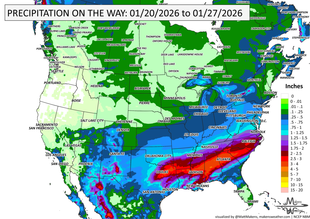
IN THE GAUGES, precipitation through the 27th:
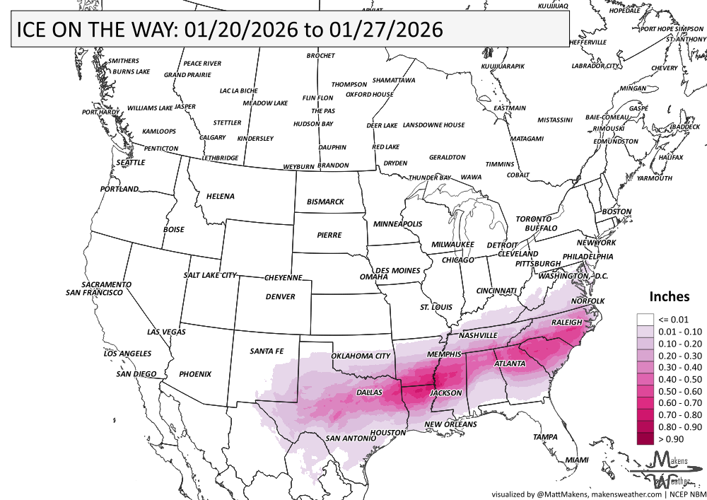
DON’T TRY IT, ICE-ACCUMULATION THROUGH THE 27TH:
GRAB A RULER, snowfall through the 27th:
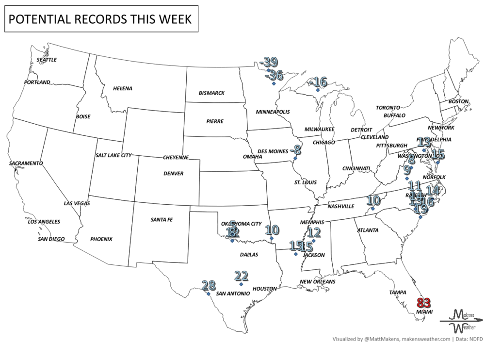
RECORDS MADE TO BE BROKEN, daily highs and lows:
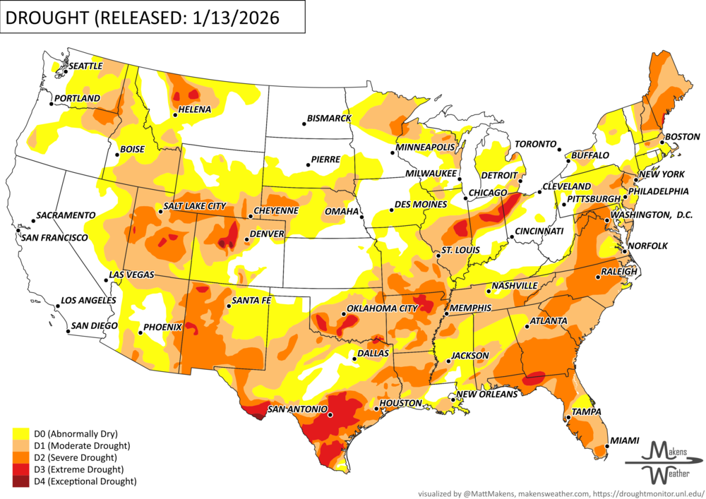
UN-DROUGHTABLY DRY:
It was a more active week nationwide, with significant precipitation across the central Plains, Midwest, and Southeast. Parts of Mississippi and Alabama received more than 5 inches of rain. In the Plains and Midwest, much of the precipitation fell as rain rather than snow due to unseasonably warm temperatures. Portions of the Southwest and central Rocky Mountains also received beneficial rain and snow, slowing drought intensification and leading to localized improvements. Temperatures were warmer than normal across most of the country, with near- to slightly below-normal temperatures limited to the West and Southwest. The largest departures occurred in the upper Midwest and northern Plains, where temperatures were 15–20°F above normal. -U.S. Department of Agriculture
ARE YOU CIRRUS?!
Today in weather history:
1883: Yuma, Arizona, sets its all-time record low of 22 degrees. The record is tied in 1911 and again in 1937.
1933: Phoenix, Arizona, receives light snow between 7:55 pm and 9:25 pm.
1937: The wettest Inaugural Day of record with 1.77 inches of rain in 24 hours. Temperatures were only in the 30s as Franklin D. Roosevelt was sworn in for his second term.
1954: Rogers Pass, Montana, plunged to 70 degrees below zero to establish a new record for the lower 48 states.

A drawn-out storm pattern will keep much of the country active through the first week of April. A slow-moving front stretching from the Great Lakes into the Plains will separate late-season snow and ice to the north from heavy rain and severe thunderstorms to the south. The setup brings the greatest impacts to parts of the Midwest, Ohio Valley, Southern Plains, Mississippi Valley, and eventually the East Coast, while the West sees mountain snow and then a warming trend heading into the weekend.