


Weekly Weather Watch: Tuesday, February 18th, 2026
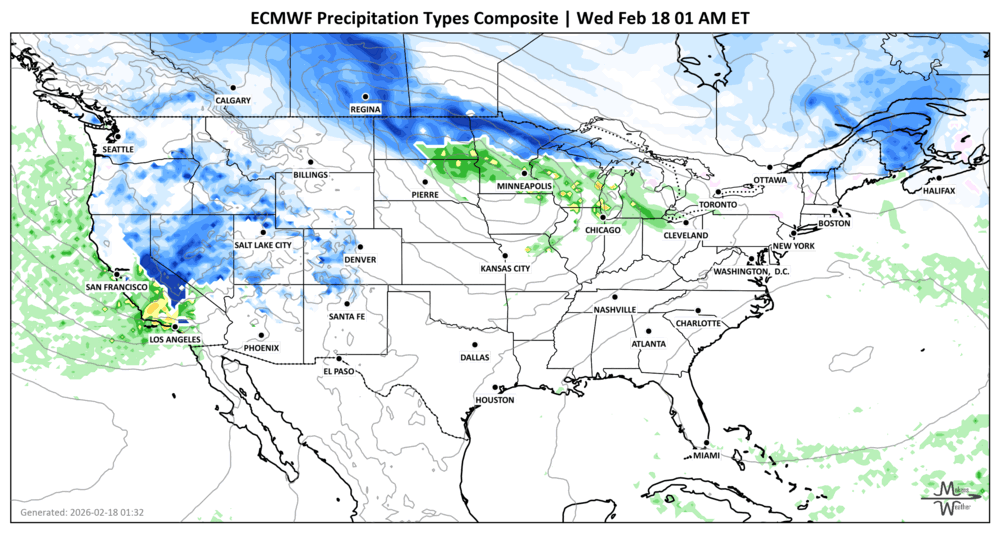
A sharp weather contrast is setting up across the country this week. Critical fire weather conditions are developing across parts of the central and southern High Plains, while repeated Pacific storms continue to bring heavy mountain snow to the West. Meanwhile, a strengthening system will spread snow and mixed precipitation from the Northern Plains to New England, and a potential coastal storm this weekend could bring wind and rain, or snow, to parts of the Mid-Atlantic and Northeast. Temperatures will swing dramatically as much colder air settles into the East by early next week. Across Canada, the heaviest snow falls in Saskatchewan and Manitoba, the coldest air east of the Rockies, and strong winds are a problem for the Prairies.
Recent thanks need to go out to CattleFax, NCBA, and the Grain & Feed Assoc of Illinois for having me speak at their conferences. I’ll be presenting in Canada a few times in the next couple of weeks, hope to see some of you there.
Unlock the Makens Weather Advantage ☀️📊
Your membership includes:
✔️ Real-time dashboard with the latest weather observations and long-range projections
✔️ Monthly-lead forecasts to plan weeks ahead
✔️ Discounts on personalized consultations for ag, energy, or risk planning
All built for decision-makers who need weather insight, not just data.
🎯 Join now and put the forecast to work for you.
📈 The latest outlooks and conditions - track it 👉 Join Now to Access the Dashboard
HEADLINERS:
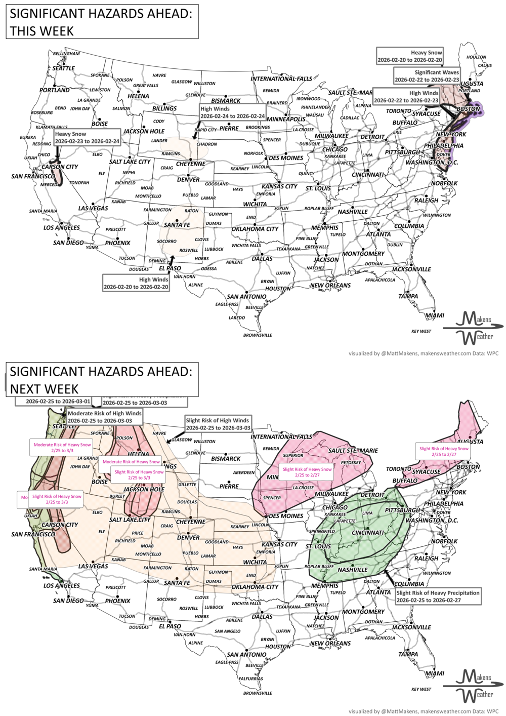
Weekly Timeline Snapshot
Wednesday–Thursday
Central & Southern High Plains: Critical fire weather with gusty winds and very low humidity.
Southern Cascades, Sierra Nevada, and Rockies: Heavy mountain snow continues; localized totals over 8 inches likely.
Northern High Plains: Snow develops behind a cold front.
Strong wind calms for the Canadian Prairies as the heaviest snowfall shifts east toward Ontario and Quebec.
Lower & Middle Ohio Valley: Strong thunderstorms possible with damaging wind gusts and a few tornadoes.
Northern & Central Plains: Moderate to heavy snow shifts east.
Friday
Great Lakes into New England: Snow and wintry mix transitioning to rain in some areas.
Four Corners & Great Basin: Lingering snow showers and mountain accumulations.
Saturday
Colder air spreads into the Ohio Valley and Mid-South.
Unsettled weather continues along the Pacific Northwest coast.
Sunday Night–Monday
Mid-Atlantic & Northeast Coast: Potential coastal storm. Track remains uncertain.
Closer-to-coast solution: Coastal rain, inland snow, gusty winds, possible coastal flooding.
Offshore track: Lighter impacts overall.
Northern California & Western Oregon: Potential atmospheric river with heavy rain and high-elevation snow.
Monday–Tuesday
Much colder temperatures across the Northeast, with highs running well below normal.
Gradual moderation expected by midweek.
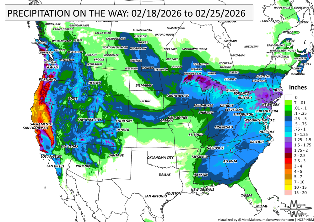
IN THE GAUGES, precipitation through the 25th:
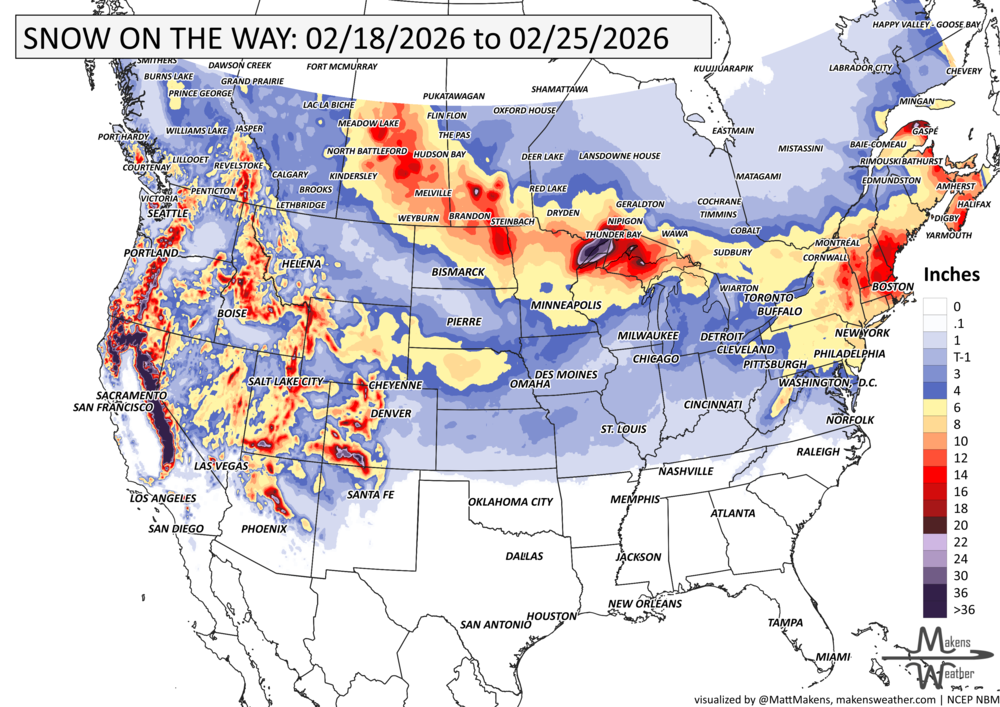
GRAB A RULER, snowfall through the 25th:
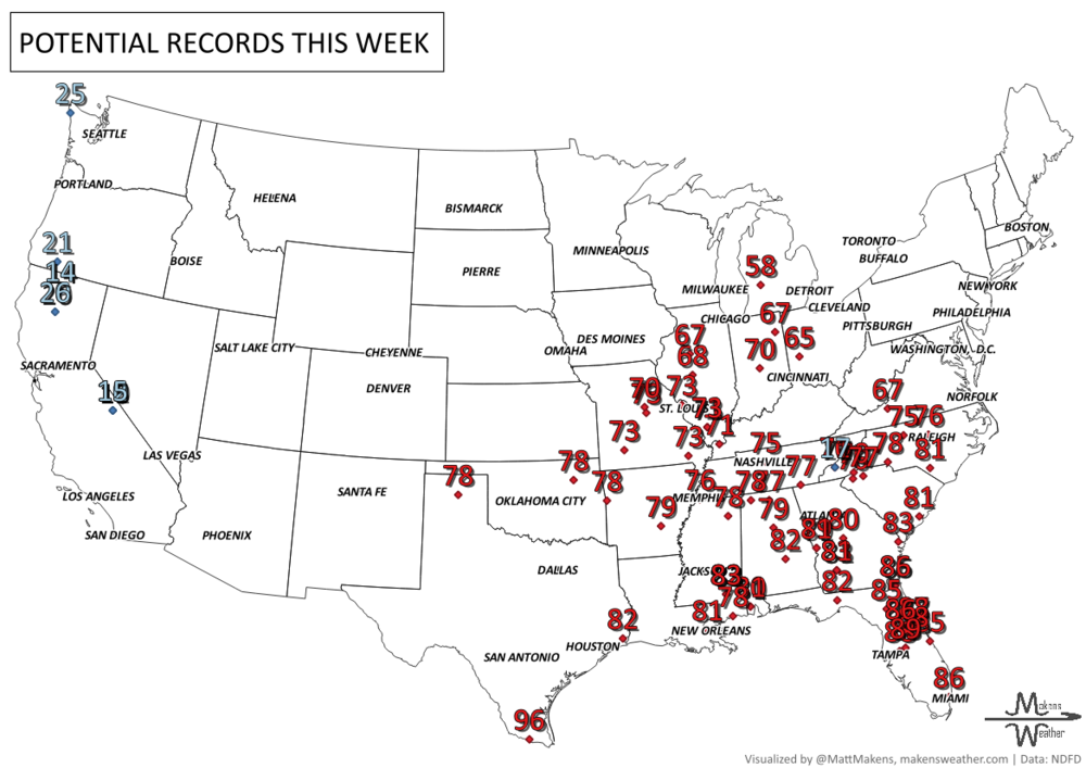
RECORDS MADE TO BE BROKEN, daily highs (RED) and lows (BLUE):
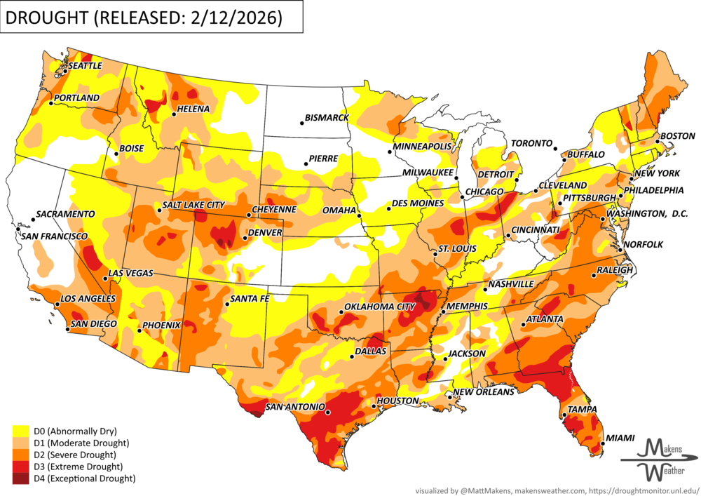
UN-DROUGHTABLY DRY:
Dry conditions continued to expand across much of the country this week, with worsening drought conditions in the Lower 48 and Alaska. A sharp temperature contrast persisted, with colder-than-normal weather in the East and warmer-than-normal conditions in the West. However, limited and highly localized precipitation led to growing moisture deficits nationwide.
Drought expanded across portions of the Pacific Northwest, northern and central Rockies, and parts of Oregon, Idaho, Montana, Wyoming, and western Colorado, where mountain snowpack remains critically low. Conditions also worsened across the High Plains and western Midwest after another mostly dry week.
In the Northeast, continued lack of meaningful precipitation contributed to deteriorating conditions in parts of Pennsylvania and southern New England. Across the southern Plains, Lower Mississippi Valley, and western Carolinas, short- and mid-term rainfall deficits deepened, with drying soils and declining streamflows supporting intensification. Fire danger is increasing in southern Georgia and Florida, where drought indicators remain elevated.
The only improvements occurred in Hawaii, where heavy trade wind rainfall brought several inches of rain — and higher-elevation snow — to windward areas of Molokai, Maui, and the Big Island, leading to modest drought relief.
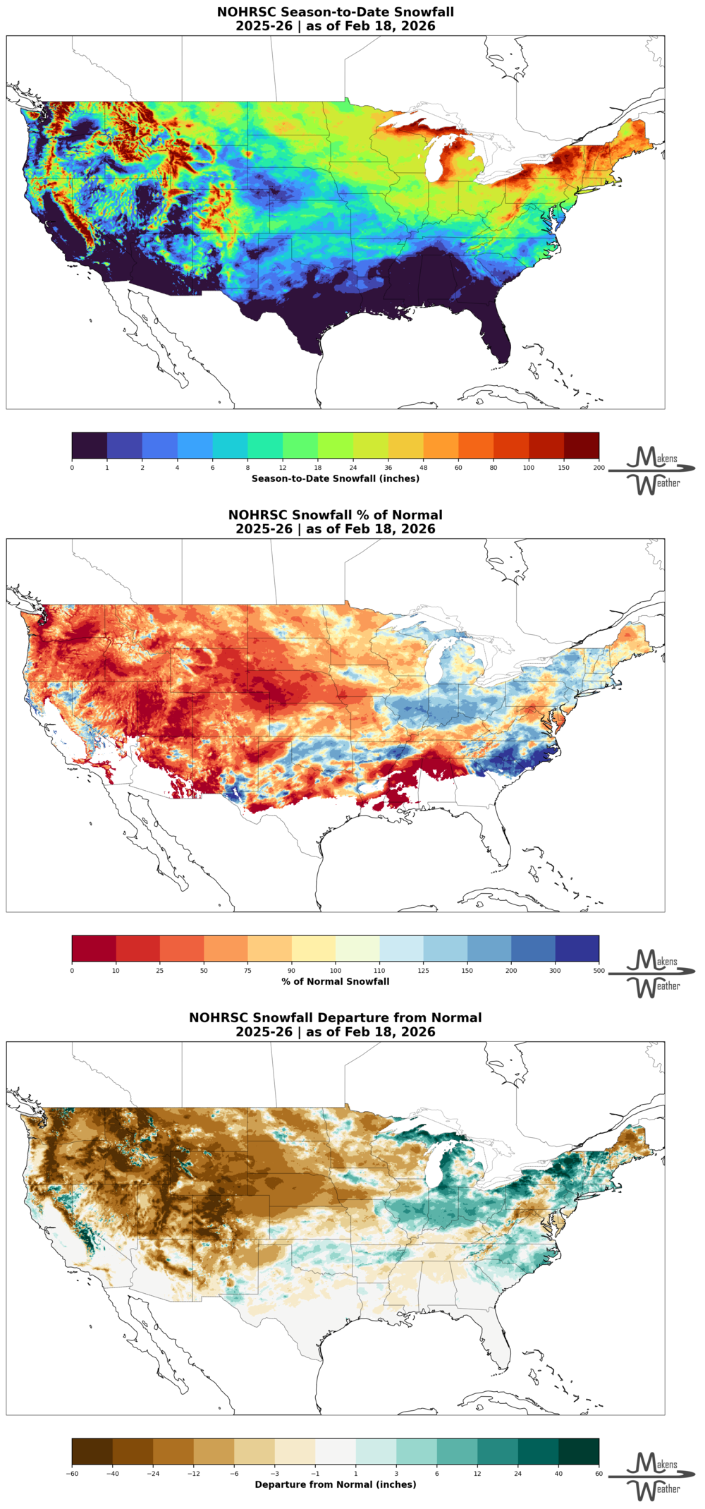
DIG DEEPER: U.S. SEASON SNOWFALL TO DATE
ARE YOU CIRRUS?!
Today in weather history:
1965: A massive avalanche kills 26 men at the Granduc Copper Mine in British Columbia.
1992: A thunderstorm spawned a powerful F4 tornado so far north for the time of the year in southern Van Wert County in Ohio. The tornado touched down just west of US Route 127 and traveled northeastward for about 3 miles. One house was completely leveled, and nine others experienced severe damage. Six people were injured.
A drawn-out storm pattern will keep much of the country active through the first week of April. A slow-moving front stretching from the Great Lakes into the Plains will separate late-season snow and ice to the north from heavy rain and severe thunderstorms to the south. The setup brings the greatest impacts to parts of the Midwest, Ohio Valley, Southern Plains, Mississippi Valley, and eventually the East Coast, while the West sees mountain snow and then a warming trend heading into the weekend.