


Weekly Weather Watch: Tuesday, October 29th, 2024
Trick or treat? Well, both actually. Moderate to heavy snow is expected over parts of the Northern/Central Rockies and higher elevations of the Great Basin. Dry and windy conditions may produce elevated to critical fire weather conditions in portions of the Central and Southern High Plains and the Midwest. Much of the central/eastern U.S. can expect record high temperatures through Thursday.
HEADLINERS:
A frost/freeze expected for parts on Colorado, Kansas, Oklahoma, and New Mexico Halloween.
Heavy rainfall for parts of the Central Plains and Midwest 11/2-11/4.
Flooding continues in parts of Florida.
Slight risk of heavy precipitation in portions of the Great Plains and Mississippi Valley, Tue-Wed, Nov 5-6.
Slight risk of high winds for portions of the eastern Rockies and Great Plains, Tue-Wed, Nov 5-6.
Slight risk of heavy snow for portions of the central and southern Rockies, Tue-Wed, Nov 5-6.
Slight risk of heavy precipitation in south-central and southeastern Alaska, Tue-Thu, Nov 5-7.
Slight risk of high winds for southern Alaska, including southwestern Alaska and the Aleutians, Tue-Thu, Nov 5-7.

ON THE RADAR:
IN THE GAUGES:
Progressing through the next three, seven, and ten days. Note the increased precipitation for parts of the Midwest toward Eastern Canada and the expansion of heavy precipitation across the West. This will be a wet period for the Osage and Flint Hills regions.

GRAB A RULER:
Heavy snowfall to hit parts of the Central and Northern Rockies, Cascades, and into parts of the Sierras.

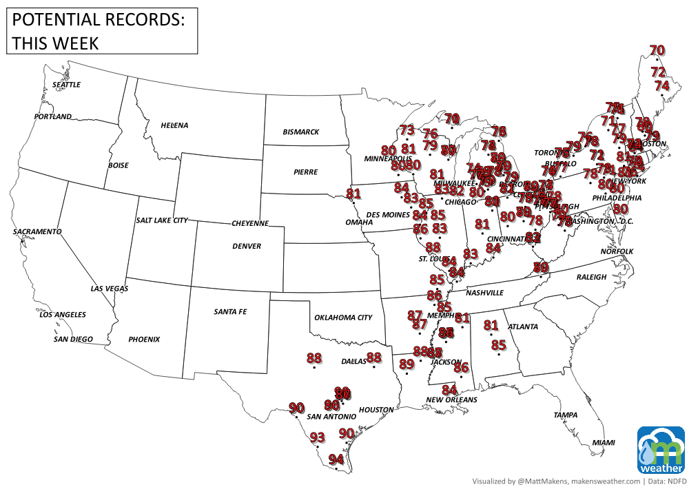
RECORDS MADE TO BE BROKEN:
TROPICAL TIDINGS:
Tropical cyclone activity is not anticipated in the next 48 hours. Modeling indicate some possibility of tropical cyclone development within the next week to two. Stay tuned.
ARE YOU CIRRUS?!
Through October, we have seen many stations set their latest first freeze in decades. I ran numbers on station since 1970 to see how many have set or may set their latest freeze on record. Those are displayed below. These records are cutoff after October, so I’ll keep this updated once we get into November and December to see how many other stations may set records this year.

MONTHLY MEMBERS:
Members have been receiving their weekly outlooks for the next month and are due to receive their November outlooks later this week. Subscribe today if an outlook stretching out the next month (updated weekly) is of importance to you.
A busy stretch of summer weather is underway. The greatest concern through midweek will be severe thunderstorms capable of damaging winds, large hail, isolated tornadoes, and flash flooding from the Dakotas into Minnesota and later the Upper Midwest. At the same time, dangerous heat continues across the Southeast, while a strengthening ridge will send temperatures soaring across the Northern Plains and Central U.S. heading into the weekend. Meanwhile, the Southwest monsoon will gradually become more active, bringing increasing rounds of afternoon and evening thunderstorms. In British Columbia and Quebec, smoke is causing or expected to cause poor air quality and reduced visibility.