


Weekly Weather Watch: Wednesday, November 6th, 2024
Another tremendously wet system is hitting the Central U.S. just days after exceptional rainfall totals measured from Oklahoma to Illinois. This latest system will snarl some commutes/travel from heavy snowfall. In the tropics, we have Hurricane Rafael to watch. There will also be record heat (mostly today) across the East. For Canada, I love seeing that snowfall on the mountains there stretching down into the States. A lot going on in the weather briefing for this week, so let’s get to it.
FYI, monthly members you should have received your November outlook on the 1st. Click here to access your content.
HEADLINERS:
Heavy snowfall for the Southwest and nearby high plains.
Heavy rains will develop for areas in the mid-Mississippi region.
Significant precipitation continues for the Cascades.
Significant snowfall for the Canadian Rockies, an significant precipitation across parts of BC.
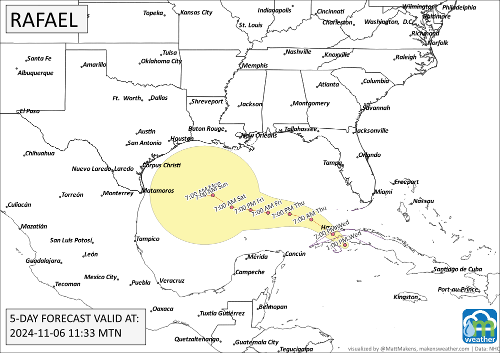
Hurricane Rafael enters the Gulf of Mexico.
Slight risk of heavy precipitation across portions of the Central and Southern Plains, Middle and Lower Mississippi, Ohio, and Tennessee Valleys, and the Southeast, Wed-Fri, Nov 13-15.
Slight risk of high winds across portions of Great Plains, Mississippi, Tennessee and Ohio Valleys, Appalachians, Mid-Atlantic, and Northeast, Wed-Fri, Nov 13-15.
Slight risk of heavy precipitation across portions of the Pacific Northwest, Wed-Fri, Nov 13-15.
Slight risk of heavy snow across northern portions of the Cascades, Wed-Fri, Nov 13-15.
Slight risk of heavy snow across many portions of the Rockies, Wed-Tue, Nov 13-19.
Slight risk of high winds for much of the western CONUS, and Central and Northern High Plains, Wed-Sun, Nov 13-17.
Slight risk of high winds across coastal portions of southwestern Mainland Alaska and the Aleutians, Thu-Sat, Nov 14-16.

ON THE RADAR:

IN THE GAUGES:
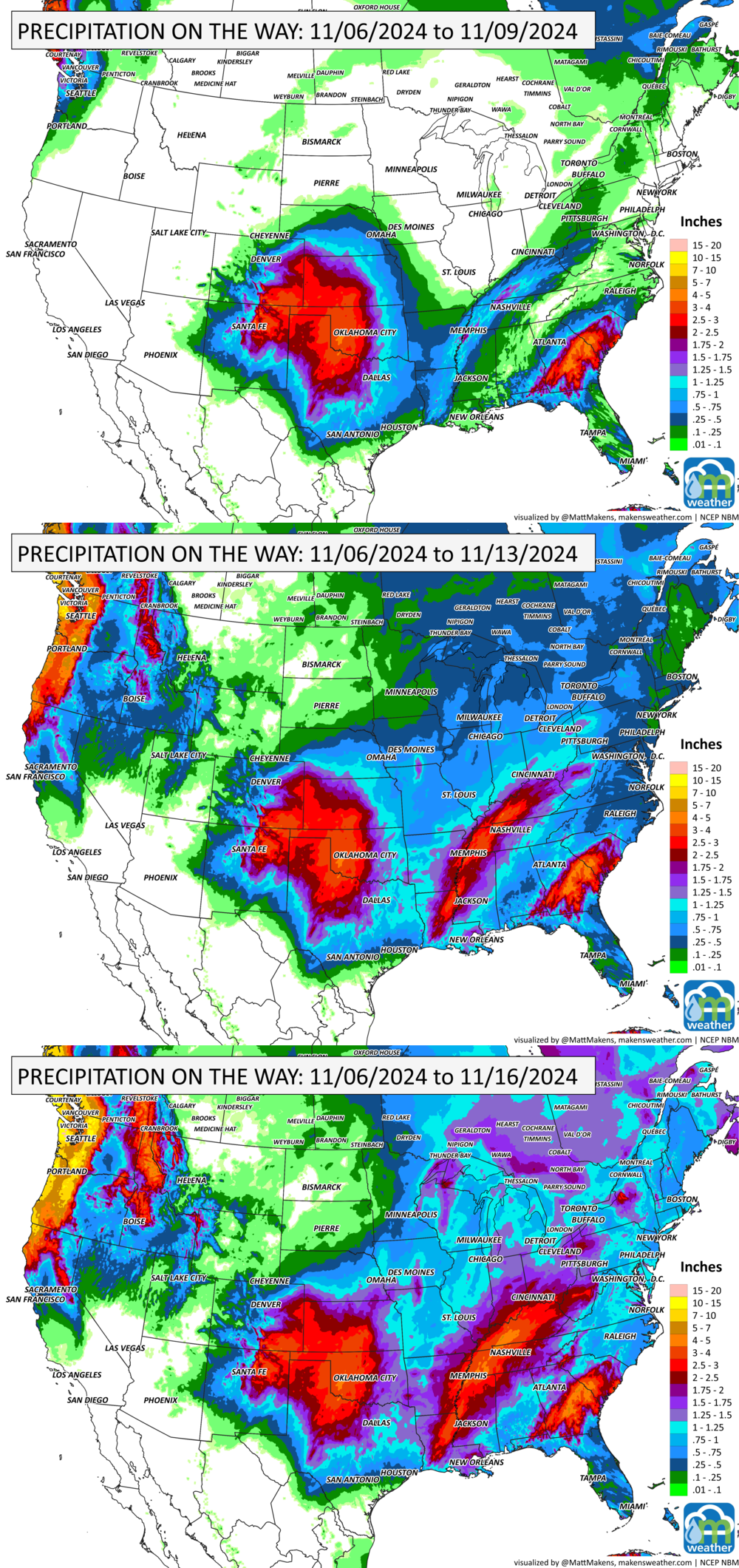
Check out the bullseye of water over the Central to Southern Plains. There’s widespread potential for at least three inches of total water here. Notice how significant precipitation then stretches from the Delta Region into the Appalachians. Plus, the Pacific Northwest hits a super wet period.
GRAB A RULER:
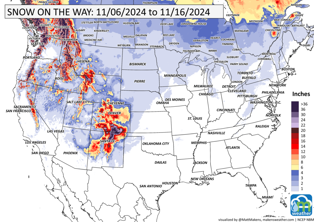
Significant snowfall totals to come during the next 10 days across the West and for the Four Corners Region.
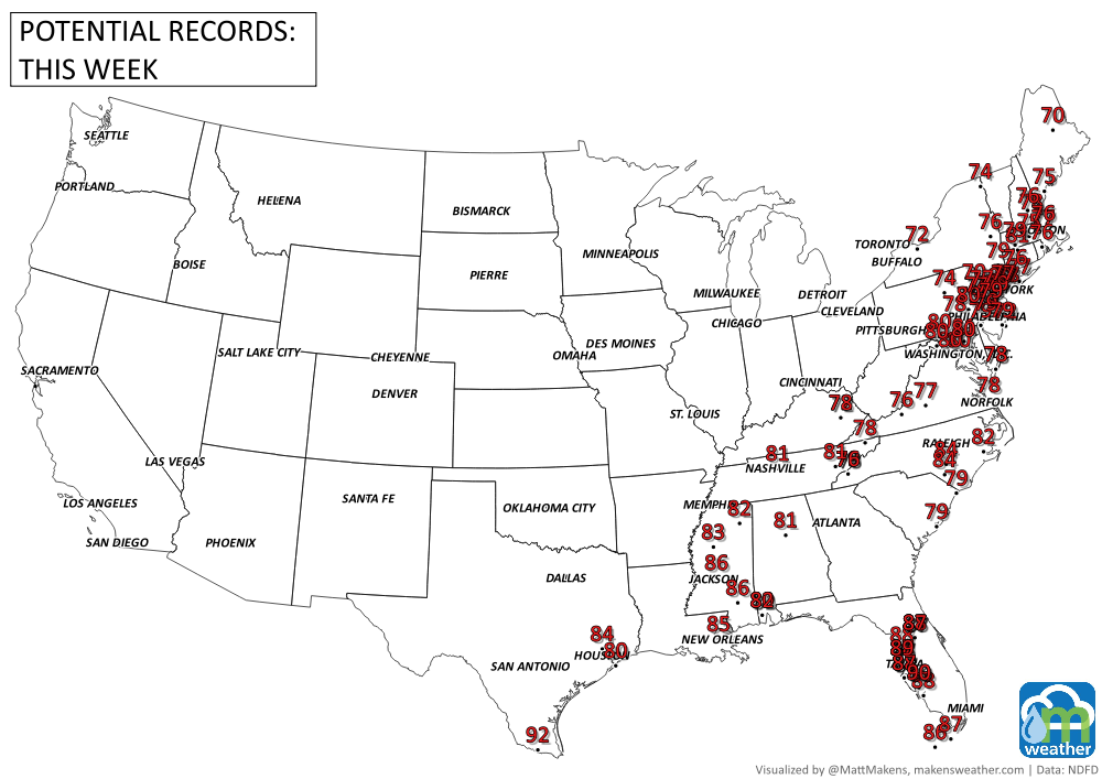
RECORDS MADE TO BE BROKEN:
Most of these records come today, Wednesday.
TROPICAL TIDINGS:
Key Messages per NHC:
1. Rafael is forecast to become a major hurricane before it reaches western Cuba and the Isle of Youth. A hurricane warning is in effect for this region, where a life-threatening storm surge, damaging hurricane-force winds, and destructive waves are expected.
2. Tropical-storm-force winds, especially in gusts, are expected in the Lower and Middle Florida Keys beginning later today and tonight.
3. Rafael will bring areas of heavy rain to the Cayman Islands and western Cuba through Thursday. Flash flooding and mudslides are expected in areas of higher terrain in western Cuba. 4. It is too soon to determine what, if any, impacts Rafael could bring to portions of the western Gulf Coast. Residents in this area should regularly monitor updates to the forecast.
ARE YOU CIRRUS?!
On this date in weather history:
1988 A powerful storm in the northern Great Lakes dropped 2 feet of snow along the shore of Lake Superior and 3 feet in the Porcupine Mountains of Upper Michigan. Marquette established a November record with 17.3 inches in 24 hours.
2001 Remnants of Hurricanes Michelle and Noel converged, then intensified over the Gulf of St. Lawrence. The massive storm blew out car windows, caused blackouts, and swamped wharves. Confederation Bridge closed for the first time ever when winds gusted up to 96 mph.

A prolonged and dangerous heat wave will dominate the weather story this week as much of the central and eastern United States experiences some of the hottest weather of the year. Heat index values above 100 degrees will become widespread, with some communities seeing readings between 105 and 115 degrees and little relief at night. At the same time, several rounds of severe thunderstorms are expected from the High Plains through the Upper Midwest and Northeast, bringing the threat of damaging winds, large hail, and localized flash flooding. Out West, cooler-than-normal temperatures will continue while dry conditions keep wildfire concerns elevated across parts of the Four Corners and Great Basin. Air quality is an issue across Alberta to Quebec due to wildfire smoke. Heavy precipitation is possible from far eastern Saskatchewan to far western Manitoba.