


Weekly Weather Watch: Wednesday, May 14th, 2025
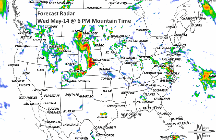
This week has quite weather contrast across the U.S. as record-breaking heat persists across central and southern Texas with highs over 100°F. Meanwhile, severe storms are expected from the Dakotas to Nebraska, and repeated rounds of thunderstorms may lead to flash flooding from the Southern Plains to the Northeast. Out West, a strong upper trough brings unusually cool temperatures and even late-season snowfall to the Rockies, with potential for over a foot at higher elevations. Locally heavy rainfall and flooding risks are expected across the Great Basin and northwestern High Plains. The heaviest precipitation across Canada will be for southeast Saskatchewan across southern Manitoba and for much of Quebec.
Interested in a membership that receives monthly outlooks, and/or custom weather information you can’t find elsewhere? Contact us today. Members, more on the summer monsoon coming in your next update.
HEADLINERS:

Record heat in southern and central Texas with 100°F+ highs and 75°F+ lows.
Scattered strong to severe thunderstorms across the northern Plains and Midwest.
Flash Flood Risk: Marginal risk zones from the southern Plains to the Mid-South and Northeast.
Late-Season Snow: Possible over 12 inches in central and northern Rockies into Alberta.
Heavy rain across the Great Basin and northwestern High Plains by Sunday.
Moderate risk of excessive heat for portions of southern Texas, Wed-Thu, May 21-22.
Slight risk of excessive heat for portions of the Southern Plains and the Lower Mississippi Valley, Wed-Sat, May 21-24.
Slight risk of excessive heat for parts of California and the Desert Southwest, Thu-Sun, May 22-25.
Slight risk of high winds for parts of the Pacific Northwest and California, Wed-Sun, May 21-25.
Slight risk of heavy precipitation for portions of the Great Lakes, Ohio Valley, Mid-Atlantic, Appalachians, and the Northeast, Wed-Thu, May 21-22.
Slight risk of high winds for much of the eastern CONUS and eastern Canada, Wed-Fri, May 21-23.
List via NOAA’s WPC & SPC.

ON THE RADAR:
KEEP AN EYE TO THE SKY:

IN THE GAUGES:

GRAB A RULER:

RECORDS MADE TO BE BROKEN:

ARE YOU CIRRUS?!
1686 Gabriel Fahrenheit, inventor of the mercury thermometer, was born.
1995 At Grissom Air Force Base in Indiana, winds were recorded reaching 136 mph.
1923 Farms were swept off the earth by what was probably an F5 tornado south of Lubbock, TX. A man and his three sons were among the 23 fatalities. The damage path was up to a mile and a half wide.
1886 At 10:00 pm, an F4 tornado hit Ohio leaving 5 dead and 20 injured. After causing one death in Indiana, the tornado destroyed farms northwest of Celina, in Mercer County. Then at 11:30 pm, an F3 tornado killed 11 and injured 25. The tornado destroyed much of Dunkirk and Cary.
A prolonged and dangerous heat wave will dominate the weather story this week as much of the central and eastern United States experiences some of the hottest weather of the year. Heat index values above 100 degrees will become widespread, with some communities seeing readings between 105 and 115 degrees and little relief at night. At the same time, several rounds of severe thunderstorms are expected from the High Plains through the Upper Midwest and Northeast, bringing the threat of damaging winds, large hail, and localized flash flooding. Out West, cooler-than-normal temperatures will continue while dry conditions keep wildfire concerns elevated across parts of the Four Corners and Great Basin. Air quality is an issue across Alberta to Quebec due to wildfire smoke. Heavy precipitation is possible from far eastern Saskatchewan to far western Manitoba.