


Weekly Weather Watch: Tuesday, December 30th, 2025
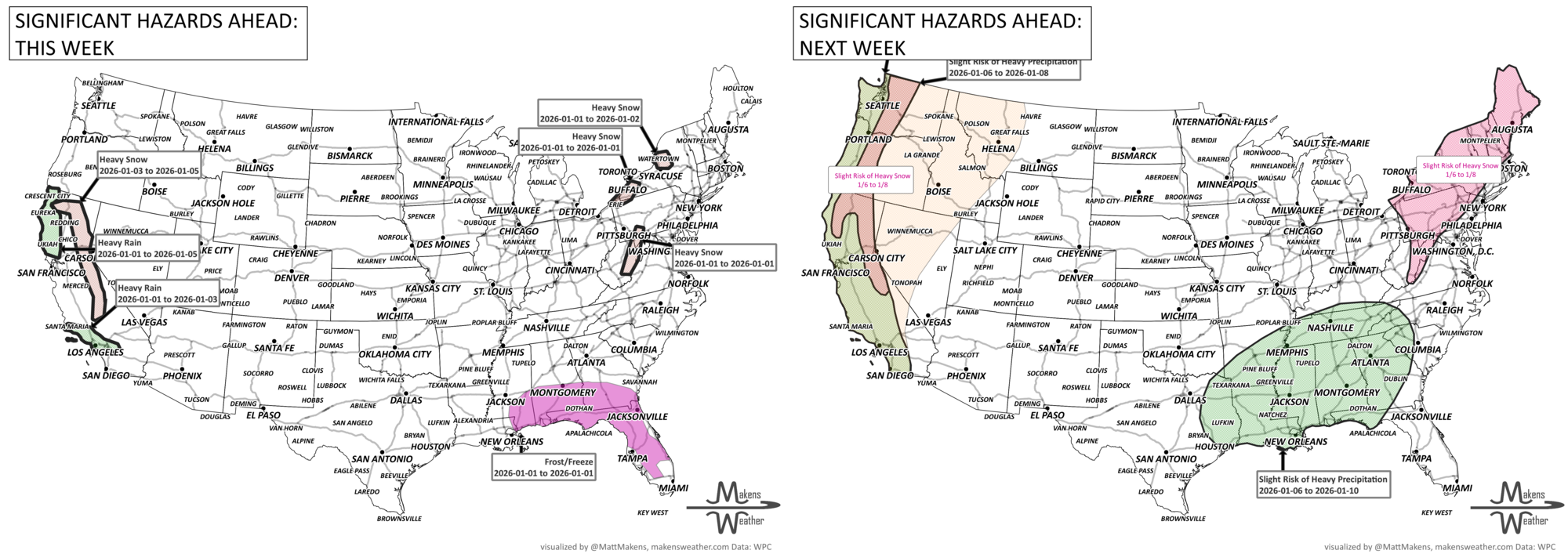
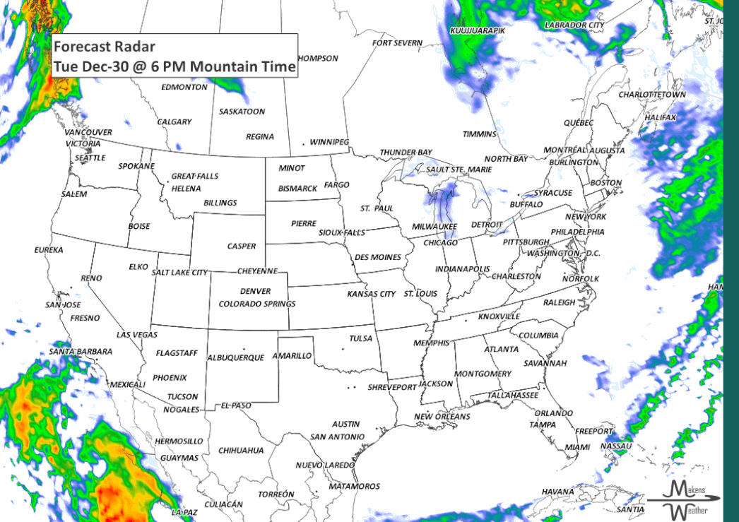
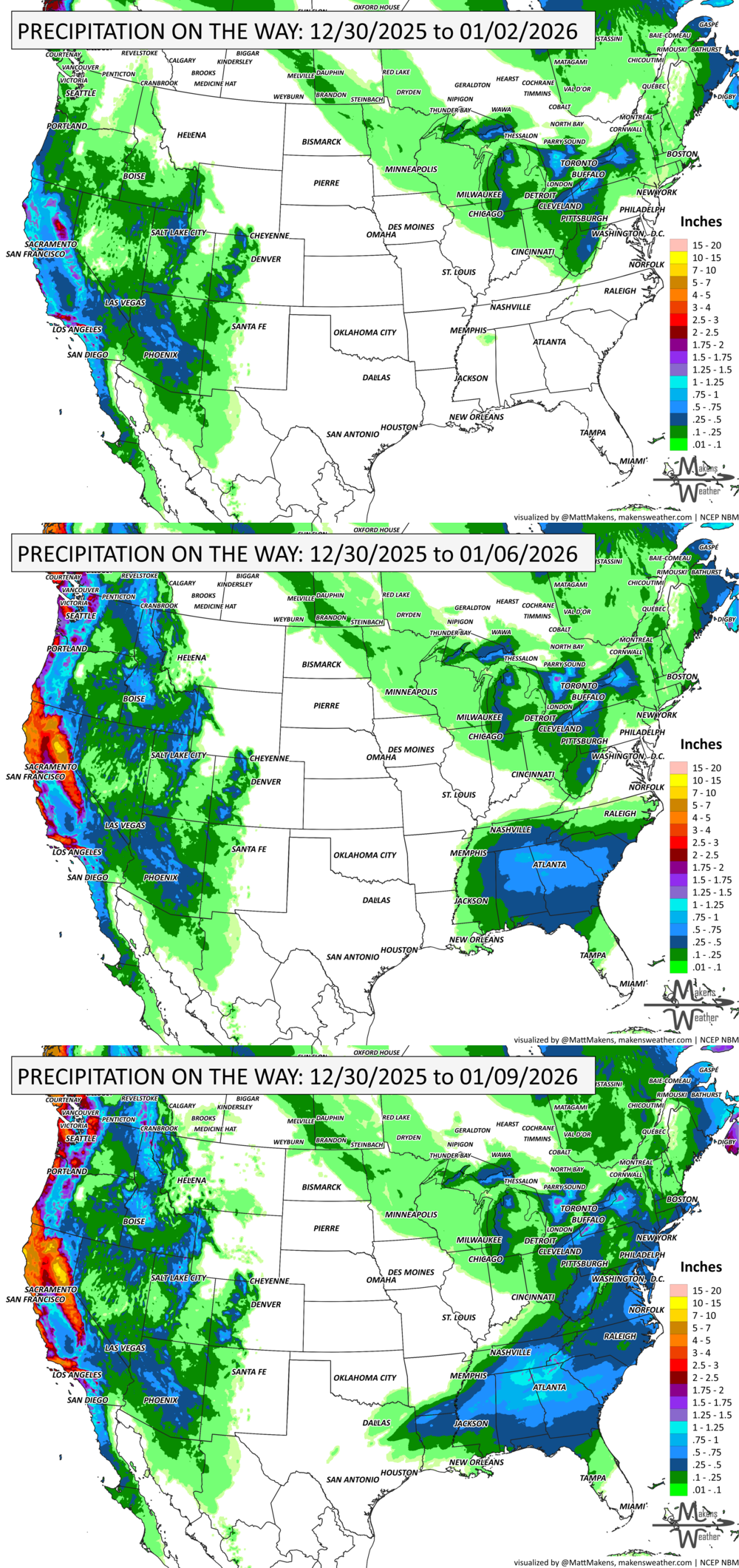
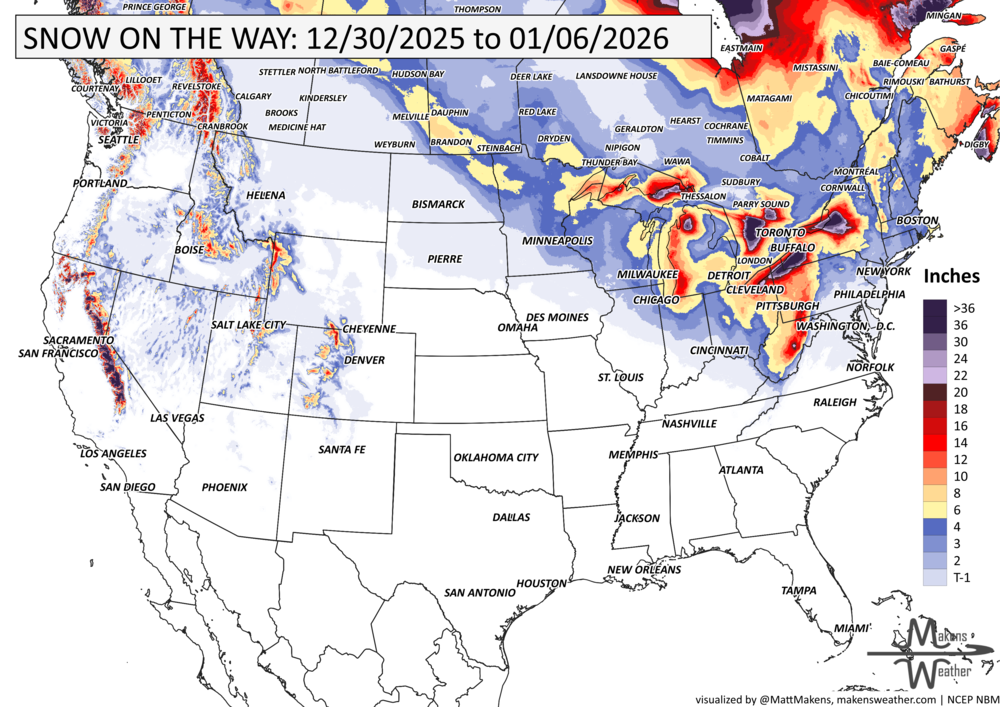
As we close out 2025 and ring in the new year, the weather pattern stays anything but quiet. A multi-day lake-effect snow event is burying areas downwind of Lakes Erie and Ontario, where over 3 feet of snow could fall in the most persistent bands—creating whiteout squalls and treacherous travel through New Year's Day. Meanwhile, Arctic air is spilling deep into the Southeast, sending temperatures below freezing as far south as Florida, with frost and freeze alerts in place. On the other side of the country, a Pacific storm system will bring rounds of heavy rain and a flash flood threat to Southern California, especially around Los Angeles, starting late New Year's Eve. Elsewhere, a couple of fast-moving clippers will spread freezing rain and snow to Alberta, then snow across the Midwest, Ohio Valley, and into New England, while a developing storm may bring soaking rain and thunderstorms from the Deep South to the Southeast Coast by the weekend. Even Northern California faces an atmospheric river event late week, setting the stage for an active and disruptive start to 2026.
Unlock the Makens Weather Advantage ☀️📊
Your membership includes:
✔️ Real-time dashboard with the latest weather observations and long-range projections
✔️ Monthly-lead forecasts to plan weeks ahead
✔️ Discounts on personalized consultations for ag, energy, or risk planning
All built for decision-makers who need weather insight, not just data.
🎯 Join now and put the forecast to work for you.
📈 The latest outlooks and conditions - track it 👉 Join Now to Access the Dashboard
HEADLINERS:
Weekly Timeline Snapshot
Tuesday, Dec 30
Lake-effect snow intensifies across western New York and northwest Pennsylvania, with whiteout squalls and near-zero visibility.
Freeze warnings in effect for much of the Deep South, including the Florida Panhandle.
Patchy freezing rain in central Alberta may lead to slick roads through the evening.
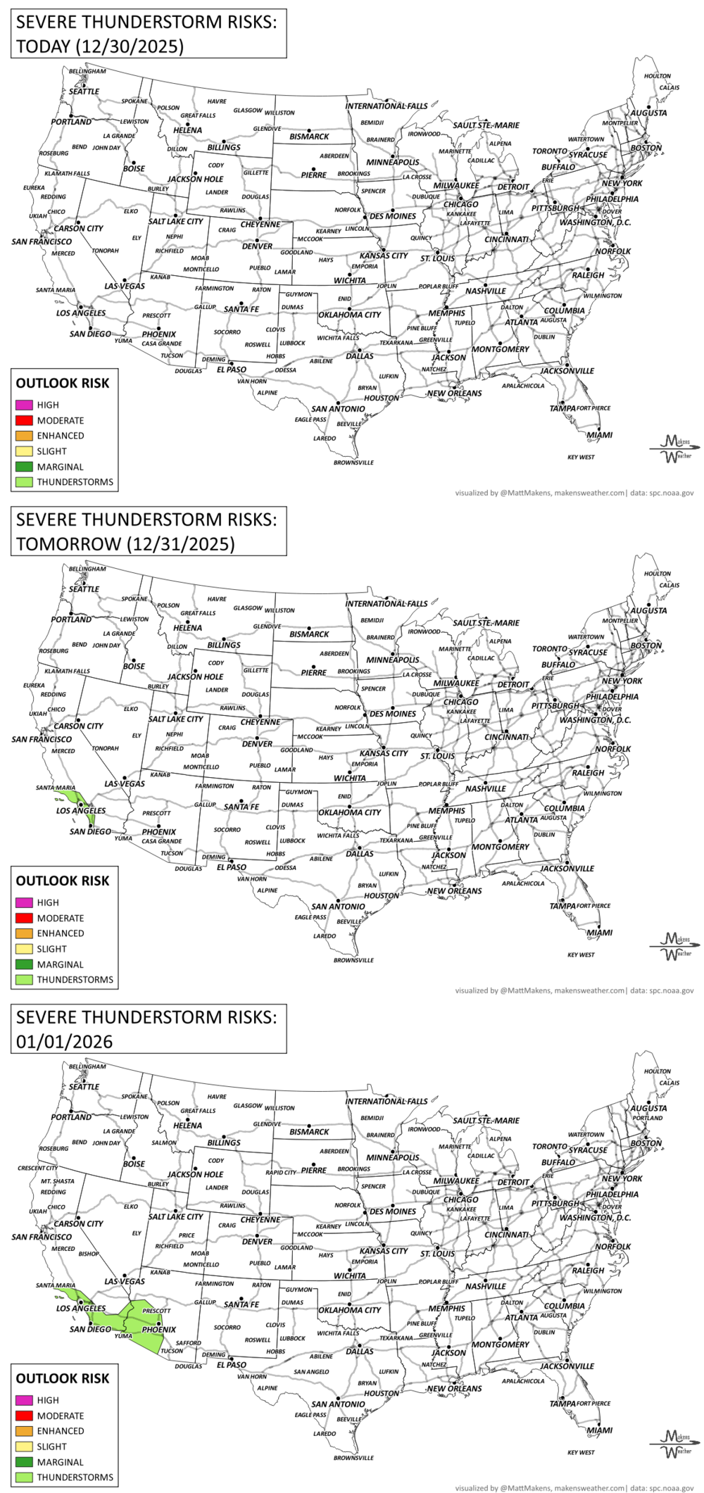
Fire danger persists in parts of Texas and the Southeast U.S. due to dry, gusty winds.
Wednesday, Dec 31 (New Year’s Eve)
Lake-effect snow continues east of the Great Lakes, tapering late in the day but squalls remain a threat.
Arctic air reaches its southernmost extent, with subfreezing temperatures likely in Tampa suburbs.
A fast-moving Alberta Clipper spreads light snow across the Ohio Valley and into the central Appalachians by night.
Heavy rain begins to approach Southern California, with increasing clouds and showers by late evening.
Thursday, Jan 1 (New Year’s Day)
Flash flooding possible in Southern California, especially around Los Angeles as tropical moisture surges in.
Rain spreads into the Desert Southwest, Great Basin, and Four Corners region.
Snow showers possible in parts of Maine, Maryland, and West Virginia.
Temperatures start to rebound across the Eastern U.S. after the Arctic chill.
Friday, Jan 2
A new storm develops in the Deep South, with rain expanding from Texas to Georgia.
Rain and snow increase across Northern California, with an atmospheric river event bringing 2–4 inches of rain and possible flooding in the northern Sierra foothills.
Mild air returns to the Central Plains behind the exiting Arctic air.
Saturday, Jan 3
Rain and some thunderstorms move through the Southeast, with potential impacts in Alabama, Georgia, and the Carolinas.
Light snow continues in Northern New England, with cold lingering but less intense than earlier in the week.
Sunday, Jan 4
Another clipper system arrives, bringing light snow across the Upper Midwest and into the Great Lakes.
Some wintry mix is possible across southern portions of the storm track, but significant impacts are not expected.
Monday, Jan 5 – Tuesday, Jan 6
Quiet weather briefly returns to the West, while below-normal temperatures hold across New England.
Warmer-than-normal conditions continue to build across the Plains and Deep South.
A third clipper system may move into the Northeast with light snow and wind.
KEEP AN EYE TO THE SKY:
IN THE GAUGES:
GRAB A RULER:
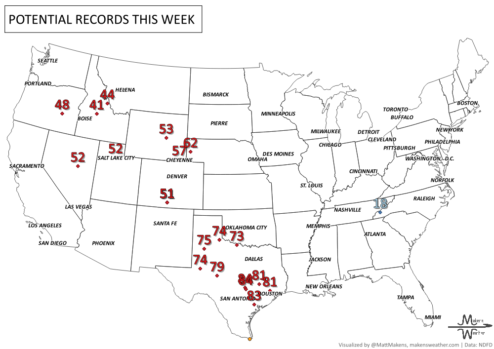
RECORDS MADE TO BE BROKEN:
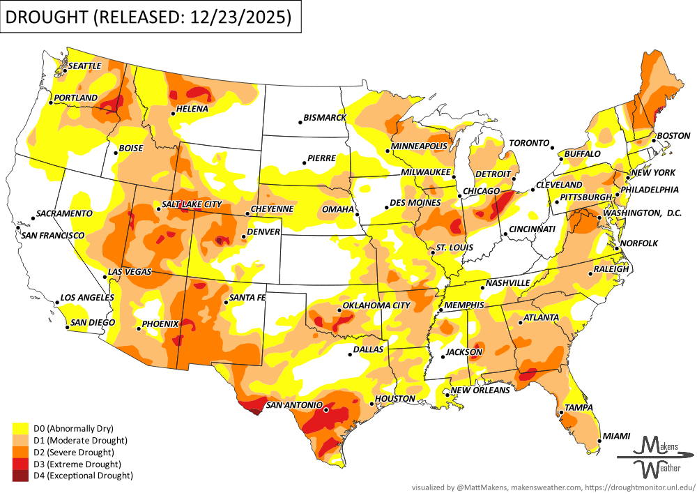
UN-DROUGHTABLY DRY:
Over the past week, strong ridging near the Aleutians and a trough over the Gulf of Alaska brought cold, dry conditions to Alaska, while an unusually strong ridge over the continental U.S. kept much of the West and Central Plains warm and dry. This warmth led to drought worsening across parts of the Rockies, Great Plains, and Mississippi Valley. Meanwhile, atmospheric rivers delivered heavy rain to the Pacific Northwest, but warm temps limited snowpack gains in the Cascades, northern Sierras, and northern Rockies. In the East, several storm systems brought widespread rain, melting recent snow and modestly improving drought in parts of the South, Ohio/Tennessee Valleys, and Northeast—though gains were limited by frozen soils and slow groundwater response. Florida saw worsening dryness under continued warmth.. -U.S. Department of Agriculture
ARE YOU CIRRUS?!
Today in weather history:
Dec 30, 1985: Wind gusts up to 63 mph swept across South Dakota, reducing visibility to near zero and blowing a semi-truck off the road near Aberdeen.
Dec 30, 2010: A blizzard hit central and northeast South Dakota with 3–6 inches of snow, wind gusts up to 40 mph, and whiteout conditions that shut down Interstates and stranded hundreds, including ice fishermen in Day County.
Dec 30, 1960: A staggering 68.2 inches of snow fell in 24 hours on Tsukayama, Japan, due to intense sea-effect snow off the Sea of Japan.
Dec 30, 2003: Las Vegas saw its first measurable snow in five years, with 1–2 inches covering roads and the Strip while flurries fell downtown.
Dec 30, 2014: Steam devils were spotted over Lake Superior near Saginaw, MN, forming in frigid air over warmer lake water.
Dec 30, 2017: Funnels and steam devils formed over Lake McConaughy, Nebraska, driven by a boundary and temperature contrasts between the lake and surrounding cold air.
A drawn-out storm pattern will keep much of the country active through the first week of April. A slow-moving front stretching from the Great Lakes into the Plains will separate late-season snow and ice to the north from heavy rain and severe thunderstorms to the south. The setup brings the greatest impacts to parts of the Midwest, Ohio Valley, Southern Plains, Mississippi Valley, and eventually the East Coast, while the West sees mountain snow and then a warming trend heading into the weekend.