


Weekly Weather Watch: Tuesday, December 16th, 2025
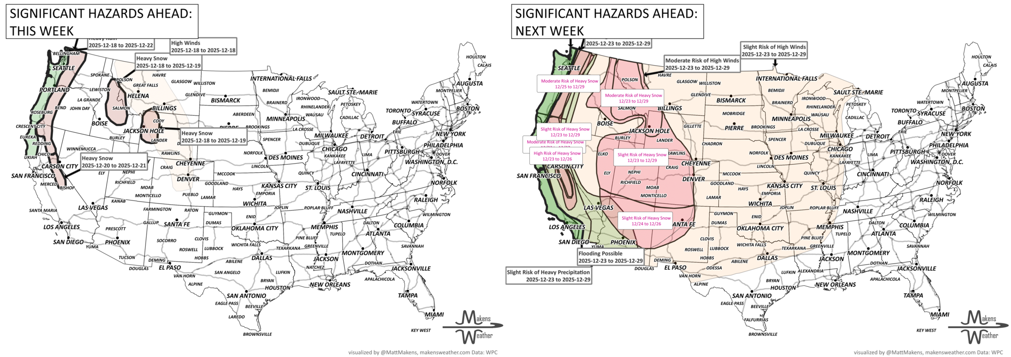
A series of Pacific storms is taking aim at the Northwest this week, delivering heavy rain, mountain snow, and gusty winds that could lead to flooding. While the West braces for more moisture, the Central and Western U.S. will bask in record-challenging warmth, with temperatures soaring 15 to 25 degrees above normal. Meanwhile, the chill that's gripped the Eastern U.S. finally begins to ease midweek, ushering in a brief break from the Arctic air. Flash freeze, snow, and wind will hit much of the Canadian Prairies, first with Alberta on Wednesday, then spreading eastward.
Unlock the Makens Weather Advantage ☀️📊
Your membership includes:
✔️ Real-time dashboard with the latest weather observations and long-range projections
✔️ Monthly-lead forecasts to plan weeks ahead
✔️ Discounts on personalized consultations for ag, energy, or risk planning
All built for decision-makers who need weather insight, not just data.
🎯 Join now and put the forecast to work for you.
📈 The latest outlooks and conditions - track it 👉 Join Now to Access the Dashboard
HEADLINERS:
Now through Wednesday:
Lake-effect snow continues east of Lake Ontario, with localized whiteout conditions.
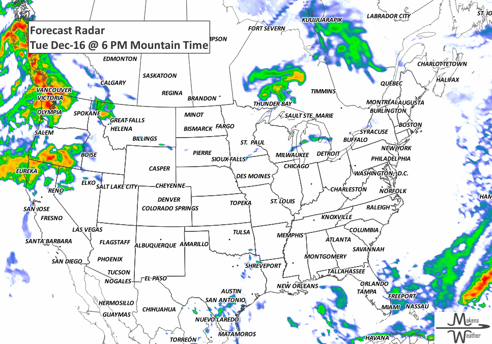
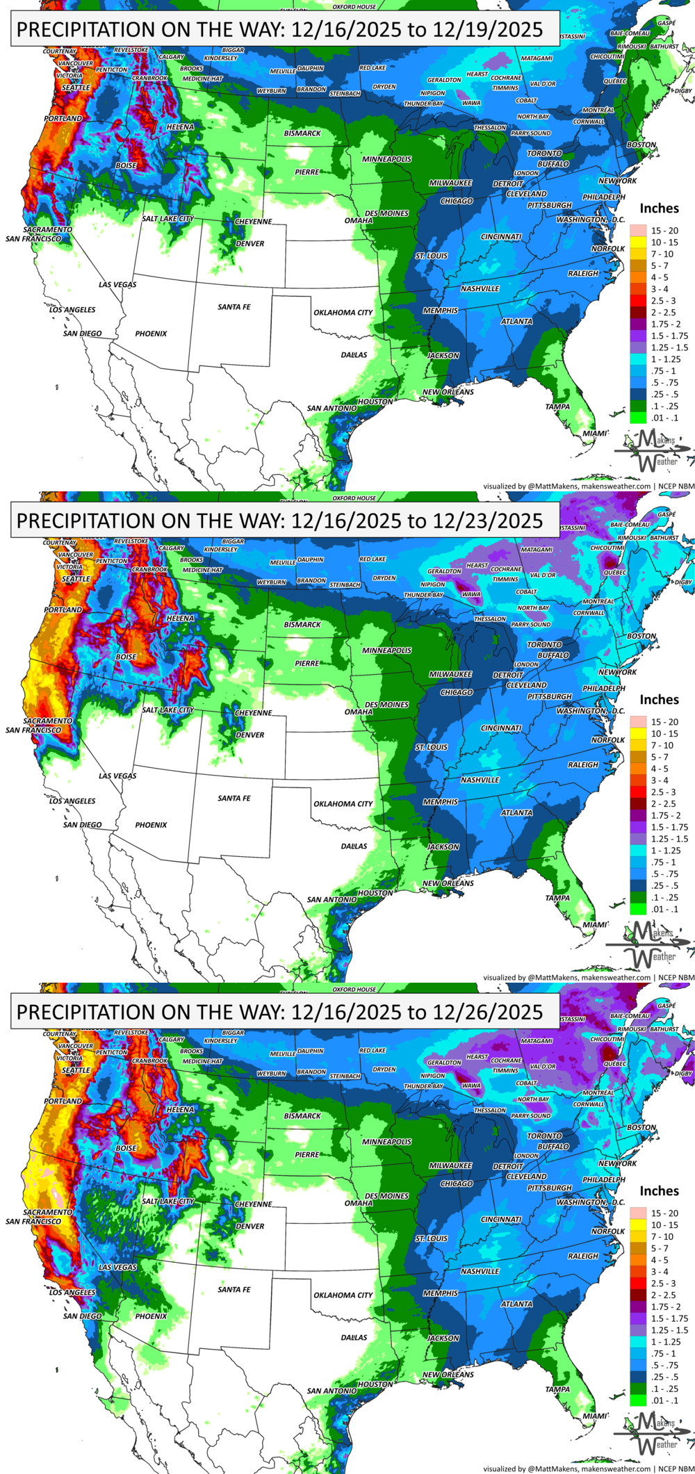
The first in a series of Pacific storms reaches the Pacific Northwest Tuesday night, bringing heavy rain and mountain snow.
Wednesday to Thursday:
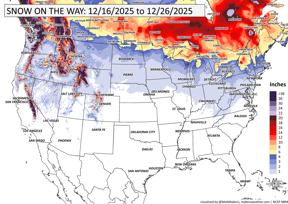
Feet of snow pile up in the Cascades and Olympics.
Heavy rain spreads from Northern California to Western Washington, while strong winds and potential flooding emerge.
Flash freeze, snow, and wind spread from Alberta to Manitoba.
Friday into the Weekend:
Another atmospheric river brings 3–5 inches of rain to northern California and southern Oregon.
Intermountain West and Northern Rockies see snow spillover.
Sunday to Monday:
Yet another storm system targets Northern California with renewed flooding potential.
Elsewhere:
South Texas sees coastal showers midweek.
New England may see quick-hitting rain on Friday, with minor runoff possible due to frozen ground.
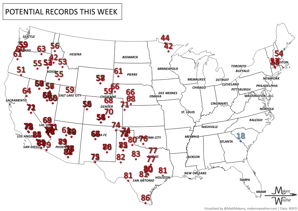
Much of the Plains and Southwest experience record-breaking warmth, with highs 15–25°F above normal.
ON THE RADAR:
KEEP AN EYE TO THE SKY:

IN THE GAUGES:
GRAB A RULER:
RECORDS MADE TO BE BROKEN:
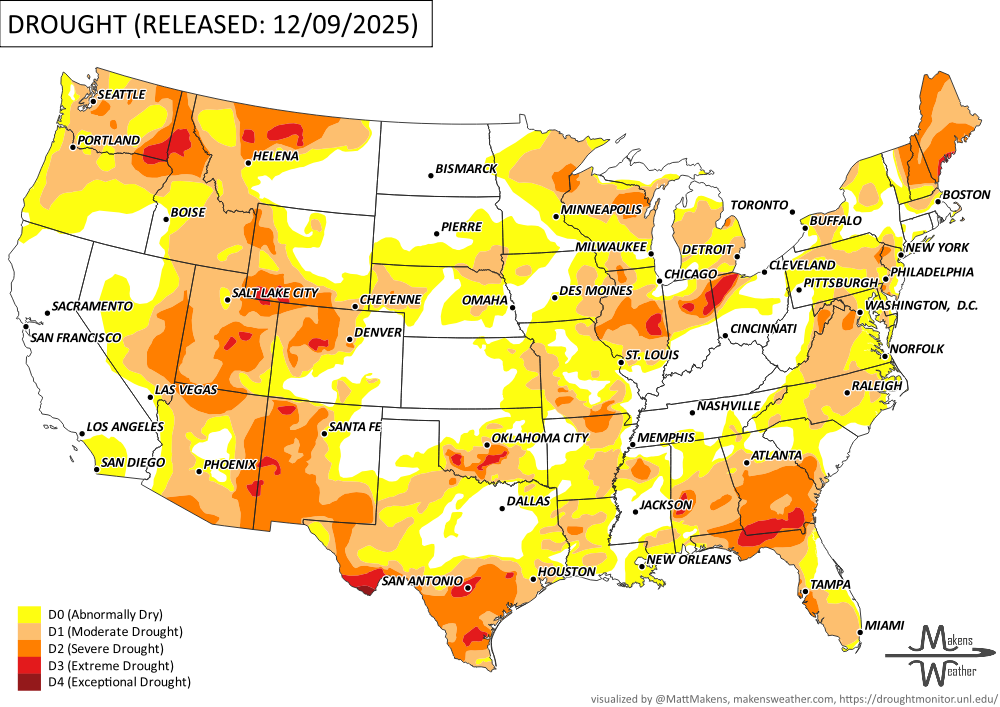
UN-DROUGHTABLY DRY:
This week’s drought picture across the U.S. was shaped by a mix of stormy weather in the West and continued dryness in the Plains and parts of the East. While much of the country was colder than normal, especially in the Midwest and Northeast, the snow didn’t do much to help short-term drought in those regions. -U.S. Department of Agriculture
ARE YOU CIRRUS?!
1835 In New York City hundreds of blocks burned during a fire. The frozen fire hydrants and gale-force winds only made the fire worse when the mercury dropped to 0.
1869 A bill was introduced in the House of Representatives, 41st Congress, calling for the taking [of] meteorological observations...and for giving notice on the northern lakes and Atlantic seaboard of the approach and force of storms. This would be signed into law on February 9, 1870, by President Grant, establishing what would come to be called the National Weather Service.
1997 Typhoon Paka deluged Guam with nearly 21 inches of rain at Tiyan before instrumentation failed. The equipment failed 2 hours before the eye of Paka passed to the south. Damage estimates were in the range of $400 million.
1997 It was dark and the airport was shrouded in fog when an Air Canada flight from Toronto to Fredericton approached the slippery runway. It skidded, bounced across a field, then slid up a snowy embankment before slamming into trees. It took rescuers 30 minutes to find the plane. The deep snowpack likely saved the lives of the passengers and crew.
1979 In Tampa Bay, the Buccaneers prepared to play the Kansas City Chiefs as rain began to pour on what was about to become the 1979 Monsoon Game. Buccaneers picked up a win with the score of 3 to 0.
A prolonged and dangerous heat wave will dominate the weather story this week as much of the central and eastern United States experiences some of the hottest weather of the year. Heat index values above 100 degrees will become widespread, with some communities seeing readings between 105 and 115 degrees and little relief at night. At the same time, several rounds of severe thunderstorms are expected from the High Plains through the Upper Midwest and Northeast, bringing the threat of damaging winds, large hail, and localized flash flooding. Out West, cooler-than-normal temperatures will continue while dry conditions keep wildfire concerns elevated across parts of the Four Corners and Great Basin. Air quality is an issue across Alberta to Quebec due to wildfire smoke. Heavy precipitation is possible from far eastern Saskatchewan to far western Manitoba.