


Weekly Weather Watch: Tuesday, August 12th, 2025
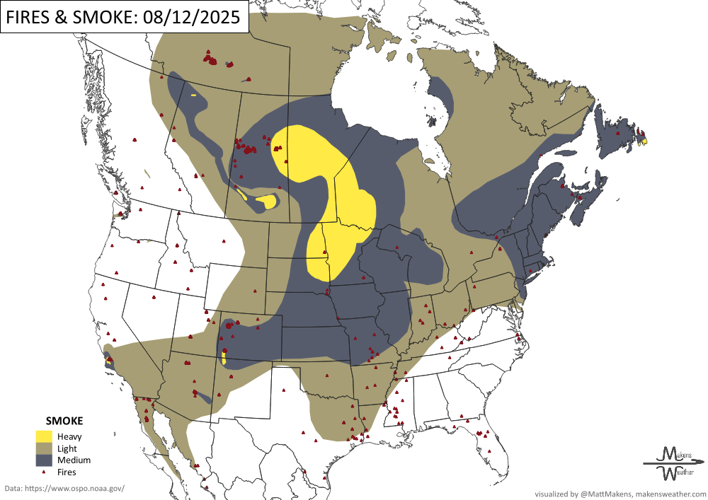
Heavy rain and flooding concerns continue today across the southern Appalachians and parts of the central Gulf Coast. Extreme heat grips much of the western U.S. and New England through midweek. Tropical Storm Erin is strengthening over the Atlantic and could become a major hurricane this weekend—East Coast residents should keep watch. In Canada, wildfire season remains intense, with hundreds of out-of-control fires fueling smoky skies and poor air quality from British Columbia to Ontario.
💧 How Much Rain Is Really On The Way?
Get Instant Answers with Our Precipitation Dashboard:
Tired of vague forecasts? Our Precipitation Dashboard gives you a clear, color-coded look at how much rain is expected—down to your region, for the next day, next 3 days, or next 7 days. Whether you're in the Plains bracing for storms, the Southeast watching flood risks, or just planning your week—this tool delivers the detail you need.
Members get full access to:
Easy-to-read maps showing total rainfall amounts
Region-specific breakdowns (Plains, Canada, Eastern U.S., and more)
Daily updates with blended-model accuracy
📈 Track it 👉 Join Now to Access the Dashboard
HEADLINERS:
Key Weather Impacts:
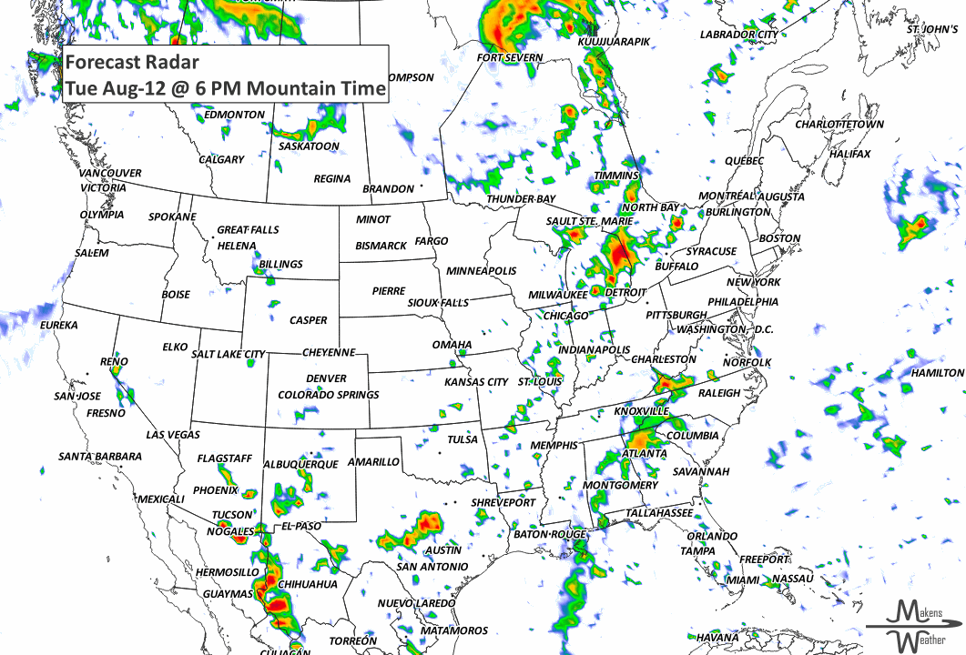
Today (Tue): Heavy to excessive rainfall over southern Appalachians & central Gulf Coast; dangerous heat from western U.S. to New England; poor air quality in BC–Ontario.
Wed: Scattered storms shift into Deep South and Mid-Atlantic; strong storms possible in northern Plains; hot, humid across Ohio Valley & Mid-Atlantic.
Thu: Cooler, drier air reaches Northeast; heat builds into central High Plains; storms in northern Plains continue.
Fri–Sat: Rain chances increase in Pacific Northwest; flash flood risk for Upper Midwest, Southeast, and Southwest.
Weekend: Heat remains in central/eastern U.S.; storms along stalled front in Upper Midwest/Great Lakes.
Early Next Week: Cooler trend in Northeast; heat shifts into Four Corners region; watch Tropical Storm Erin for possible approach to western Atlantic.

ON THE RADAR:
KEEP AN EYE TO THE SKY:

IN THE GAUGES:

RECORDS MADE TO BE BROKEN:

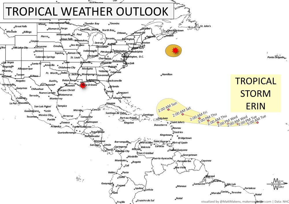
TROPICAL TIDINGS:
Tropical Storm Erin is forecast to strengthen into a Major Hurricane over the central Atlantic this weekend; East Coast residents should monitor future forecasts for any potential impacts.
A low pressure southeast of Nova Scotia has a low (10%) chance of tropical or subtropical development before moving over cooler waters midweek.
A surface trough near Louisiana will bring locally heavy rain to parts of the northern Gulf Coast today, but tropical development is not expected.
fire!
ARE YOU CIRRUS?!
1778 A hurricane struck Rhode Island, causing extensive damage. It prevented an impending sea battle between the French and British during the Revolutionary War.
A busy stretch of summer weather is underway. The greatest concern through midweek will be severe thunderstorms capable of damaging winds, large hail, isolated tornadoes, and flash flooding from the Dakotas into Minnesota and later the Upper Midwest. At the same time, dangerous heat continues across the Southeast, while a strengthening ridge will send temperatures soaring across the Northern Plains and Central U.S. heading into the weekend. Meanwhile, the Southwest monsoon will gradually become more active, bringing increasing rounds of afternoon and evening thunderstorms. In British Columbia and Quebec, smoke is causing or expected to cause poor air quality and reduced visibility.