

Flood threats will mark Hurricane Hilary’s historic arrival in California as record rainfall totals are expected. The heat across the Central and Southern U.S. remains oppressive.
Read More
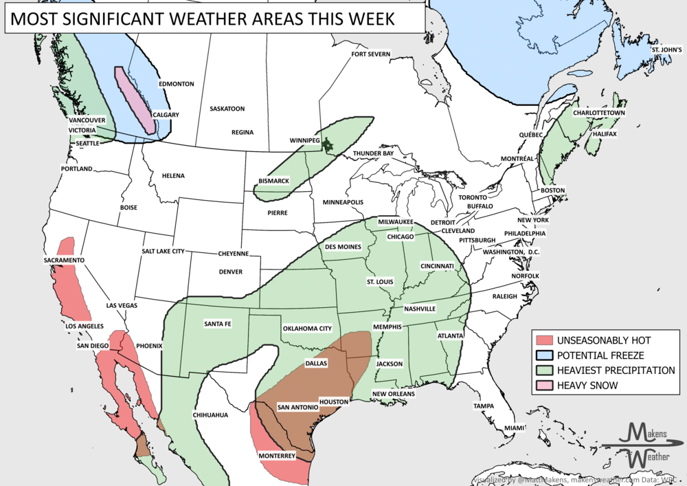
Pacific tropical moisture will drive one of the bigger weather stories this week as it gets pulled north into a slow-moving storm over the Southwest. New Mexico and western Texas face the greatest flash-flood threat early in the week, before heavy rain expands across the Southern Plains, Central Plains and Midwest. Some areas could pick up 3 to 6 inches of rain, with locally higher totals. The wet pattern won’t end quickly either, with the threat gradually shifting east toward the Mississippi and Tennessee Valleys later this week and into the weekend. Meanwhile, the Nor’easter affecting New England is winding down, while late-season heat hangs on across southern Texas and eventually builds across parts of the West.
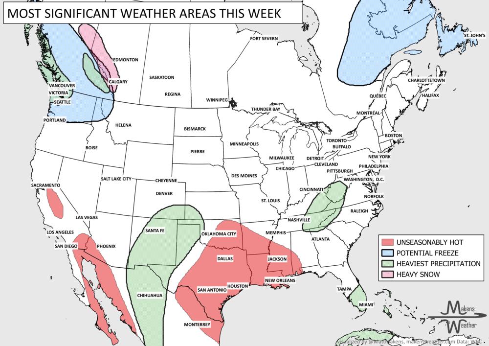
A busy weather pattern will bring several areas of concern through the next week. New Mexico and west Texas face the first significant threat as tropical moisture fuels rounds of heavy rain Tuesday and Wednesday, raising the risk of flash flooding and debris flows near recent burn scars. Farther east, showers and thunderstorms will produce pockets of heavy rain from the Ohio Valley and Southeast into the Mid-Atlantic. By late week, attention shifts to a slow-moving coastal storm near the Mid-Atlantic and Northeast, where several days of onshore winds could bring heavy rain, coastal flooding, high surf and beach erosion. Meanwhile, cooler weather settles into much of the northern and eastern U.S., while summerlike warmth hangs on across the southern Plains and Lower Mississippi Valley.
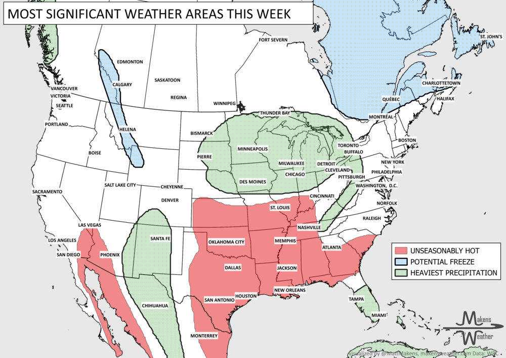
Late-summer weather is hanging on across the south-central U.S., where another stretch of hot, humid days will continue through much of the week. Farther north and west, heavy rain will be the bigger concern. Several rounds of thunderstorms could produce flooding from the Central Plains into the Upper Midwest, while monsoon moisture keeps showers and storms active across the Southwest and Southern Rockies. The pattern begins to change later this week, allowing the southern heat to ease while the focus for heavier rain shifts east toward the Great Lakes and Northeast. A frost possible across Canada, with a first freeze more likely for Quebec and the Maritimes.
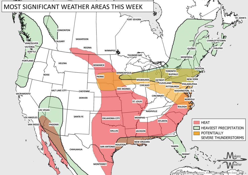
The main story this week is a sharp contrast across the country. Tropical Storm Edouard brings heavy rain, coastal flooding concerns and strong winds to Upper Texas and southwestern Louisiana through Wednesday, while rounds of thunderstorms may produce severe weather and localized flash flooding from the Great Lakes and Northeast into the Mid-Atlantic. Meanwhile, a stubborn late-summer heat wave holds across the Central and Southern Plains and spreads east before a cold front brings some relief this weekend. Out West, the Pacific Northwest stays unusually cool and showery, while monsoonal moisture increases the chance for locally heavy rain and flash flooding across the Southwest.
The main story this week is a sharp contrast across the country. Tropical Storm Edouard brings heavy rain, coastal flooding concerns and strong winds to Upper Texas and southwestern Louisiana through Wednesday, while rounds of thunderstorms may produce severe weather and localized flash flooding from the Great Lakes and Northeast into the Mid-Atlantic. Meanwhile, a stubborn late-summer heat wave holds across the Central and Southern Plains and spreads east before a cold front brings some relief this weekend. Out West, the Pacific Northwest stays unusually cool and showery, while monsoonal moisture increases the chance for locally heavy rain and flash flooding across the Southwest.
Flood threats will mark Hurricane Hilary’s historic arrival in California as record rainfall totals are expected. The heat across the Central and Southern U.S. remains oppressive.
Read More
Pacific tropical moisture will drive one of the bigger weather stories this week as it gets pulled north into a slow-moving storm over the Southwest. New Mexico and western Texas face the greatest flash-flood threat early in the week, before heavy rain expands across the Southern Plains, Central Plains and Midwest. Some areas could pick up 3 to 6 inches of rain, with locally higher totals. The wet pattern won’t end quickly either, with the threat gradually shifting east toward the Mississippi and Tennessee Valleys later this week and into the weekend. Meanwhile, the Nor’easter affecting New England is winding down, while late-season heat hangs on across southern Texas and eventually builds across parts of the West.