


Weekly Weather Watch: Wednesday, October 2nd, 2024
Thoughts and prayers to those impacted by Hurricane Helene. For those in the Southeast, additional moisture will be arriving, which means the risk of additional flooding will continue for quite some time. There is also additional activity in the tropics to track. For most of the U.S., heat for the West, a chill for the North, and drought expansion are expected this week. Here is your weekly weather briefing. MONTHLY MEMBERS, you received your October weather guidance yesterday. Please check your inboxes or log in here.
HEADLINERS:
A risk for frost/freeze across Canada and the Northern U.S. Oct 3 and 4th.
Record-setting heat for the Southwestern U.S. the 4th.
Slight risk of heavy precipitation for parts of the Southeast U.S., Wed-Fri, Oct 9-11.
Possible flooding for parts of the Southeast U.S.
Risk of Rapid Onset Drought (ROD) across portions of Oklahoma, Texas, western Arkansas, and western Louisiana.

ON THE RADAR:

IN THE GAUGES:
Significant rainfall for Florida and moisture for the Coastal Pacific Northwest and eastern Canada.

GRAB A RULER:
Little snowfall for the states, but a fair bit for B.C.

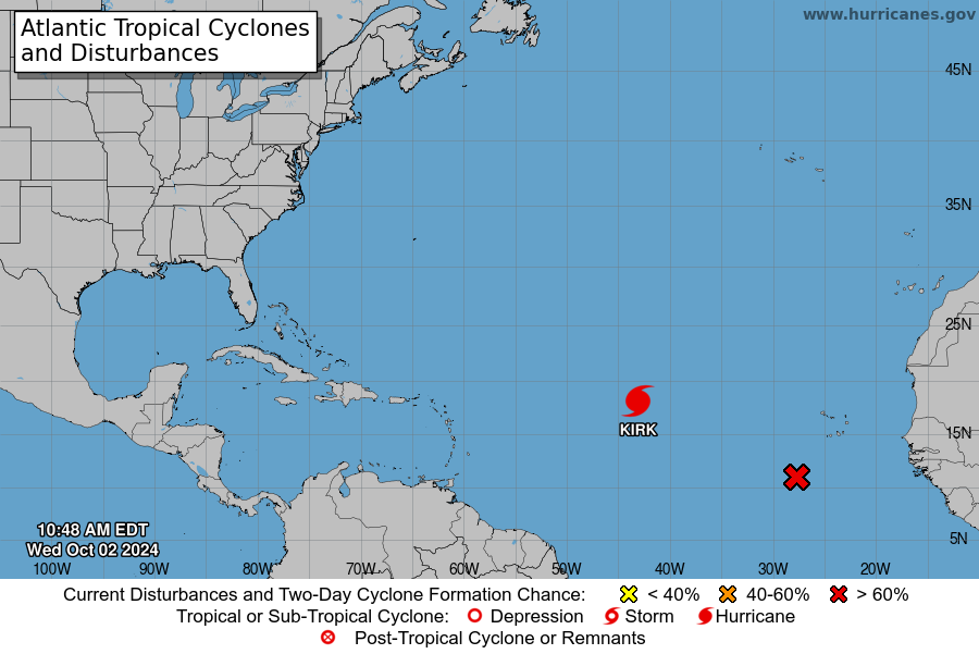
TROPICAL TIDINGS:
Hurricane Kirk is likely to remain over open waters. There is a new wave, depicted with the red X, that likely develops into an organized tropical cyclone.
RECORDS MADE TO BE BROKEN:

ARE YOU CIRRUS?!
Extreme Totals and Flooding from Helene
Over that three-day window from Wednesday, September 25 through Friday, September 27, rainfall totals exceeded eight inches across our Mountain region, with a foot or more falling in parts of Alleghany County and in a swath from Boone through Brevard.
More than 18 inches fell across southern Yancey County, western McDowell County, southeastern Buncombe County, and northwestern Rutherford County. That included 24.41 inches at our ECONet station on Mount Mitchell and 19.99 inches at our station on Bearwallow Mountain.
The highest apparent total from the event came from the North Carolina Forest Service’s RAWS station in Busick, with a three-day accumulation of 31.33 inches. While unvalidated at this point, radar estimates back up the potential for two feet of rain or more in Yancey County.
In addition to these automated weather stations, four CoCoRaHS observers recorded three-day totals of more than 20 inches: 24.12 inches in Spruce Pine, 22.36 inches in Foscoe, 22.12 inches south of Black Mountain, and 21.96 inches south of Hendersonville.
At least a dozen weather stations had their wettest three-day periods on record during this event, including the National Weather Service’s Cooperative Observer stations in Celo (19.98 inches), Sparta (17.29 inches), and Boone (16.67 inches).
-Read more: North Carolina State Climate Office
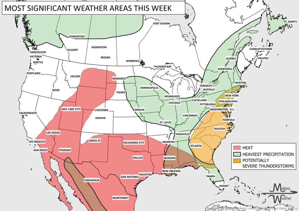
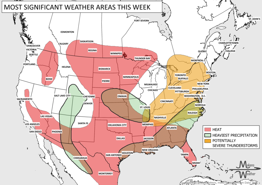
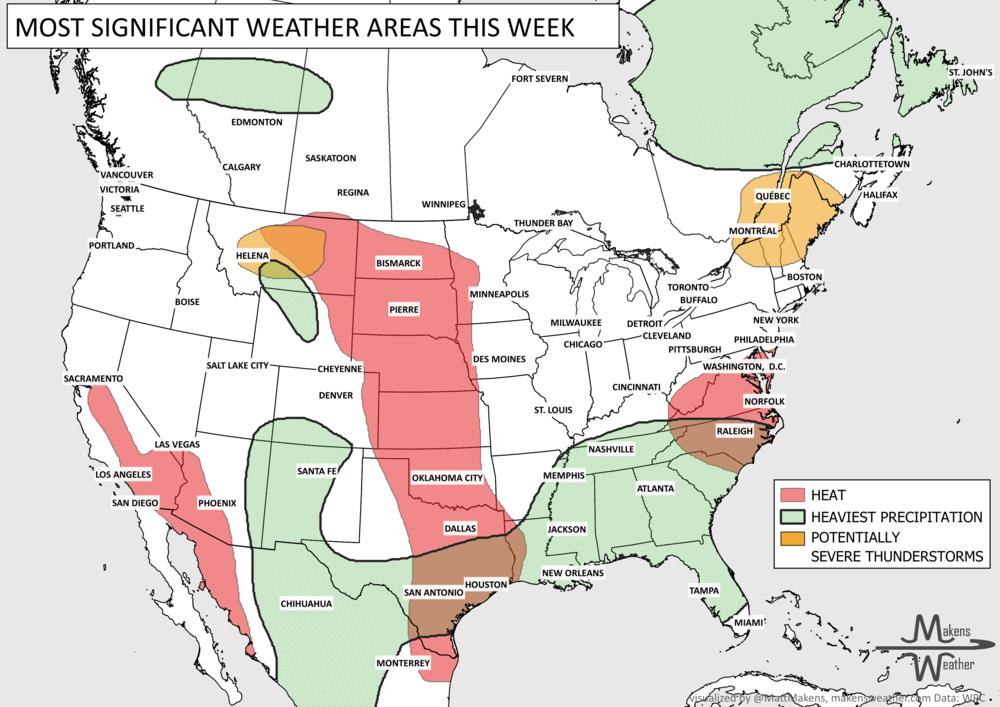
The weather pattern across the United States and Canada remains highly active this week, with two major stories dominating the forecast. Dangerous, long-lasting heat continues across much of the South before expanding into the western United States by the weekend. At the same time, repeated rounds of thunderstorms will bring the threat of flash flooding and severe weather from the Mid-Atlantic and Northeast to parts of the Midwest and Gulf Coast. Residents across these regions should stay weather-aware as heavy rain, damaging winds, and dangerous heat create multiple hazards over the coming week.