


Weekly Weather Watch: Tuesday, November 26th, 2024
Approaching the U.S.’s Thanksgiving holiday with heavy mountain snows to the West, slowing drivers through the Rockies. That’s the leading topic, but there’s a lot more to get to in this week’s Weather Watch. A significant arctic outbreak will arrive in the northern Rockies and Northern Plains on Thanksgiving into Friday and advance farther south and east through much of the Plains and Midwest this weekend. Dangerous wind chill temperatures are expected with a significant long duration lake effect snow event possible downwind of the Great Lakes. Severe thunderstorms may be possible in the Southeast. Heavy precipitation stretches across British Columbia and Alberta and freezing rain with snow squalls for Ontario and Quebec.
HEADLINERS:
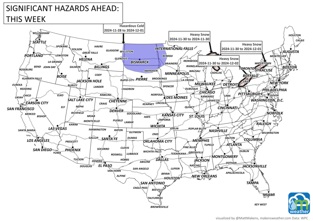
Arctic cold will spread across the Northern Plains, with below-normal temperatures reaching most areas east of the Rockies.
There will be multiple days of potentially heavy lake effect snow late this week into early next.
On Tuesday, December 3rd, there's a high chance of much colder-than-normal temperatures in much of Alabama and Georgia, stretching into the Florida Panhandle.
A moderate chance of much colder-than-normal temperatures will affect most of the Southeast, Tennessee Valley, and southern Mid-Atlantic region from Tuesday to Wednesday, December 3rd-4th.
There's a slight chance of much colder-than-normal temperatures from eastern parts of the Lower and Middle Mississippi Valley all the way to the Atlantic coast, including southern New England to central Florida, from Tuesday, December 3rd through Monday, December 9th.
There's a slight risk of heavy snowfall in areas downwind of the Great Lakes, possibly reaching as far south as the Smoky Mountains in eastern Tennessee, from Tuesday to Saturday, December 3rd-7th.
A slight risk of strong winds will impact much of the northern Mississippi Valley, Great Lakes, and Ohio Valley, extending to the East Coast from Maine to Virginia, from Tuesday, December 3rd to Monday, December 9th.

ON THE RADAR:
EYES TO THE SKIES:

IN THE GAUGES:

GRAB A RULER:

RECORDS MADE TO BE BROKEN:

TROPICAL TIDINGS:
Nothing imminent at this time in the Tropical Atlantic.
ARE YOU CIRRUS?!
On this date in weather history
1983 A major snowstorm hit from Colorado to Wisconsin from the 26th to the 28th. One to two feet of snow was reported with Sydney, NE observing the most with 27 inches. Blizzard conditions prevailed with wind gusts as high as 60 mph. Limon, CO reported near zero visibility in snow and blowing snow for a solid 24 hours.
A prolonged and dangerous heat wave will dominate the weather story this week as much of the central and eastern United States experiences some of the hottest weather of the year. Heat index values above 100 degrees will become widespread, with some communities seeing readings between 105 and 115 degrees and little relief at night. At the same time, several rounds of severe thunderstorms are expected from the High Plains through the Upper Midwest and Northeast, bringing the threat of damaging winds, large hail, and localized flash flooding. Out West, cooler-than-normal temperatures will continue while dry conditions keep wildfire concerns elevated across parts of the Four Corners and Great Basin. Air quality is an issue across Alberta to Quebec due to wildfire smoke. Heavy precipitation is possible from far eastern Saskatchewan to far western Manitoba.