


Weekly Weather Watch: Tuesday, November 25th, 2025
As Thanksgiving week kicks off, a powerful storm system is sweeping coast to coast with major impacts. Heavy snow, gusty winds, and lake-effect snow are creating travel headaches across the northern Plains, Upper Midwest, Ontario, Quebec, and Great Lakes, while the Deep South and Southeast contend with rounds of heavy rain and severe thunderstorms. Behind it all, a sharp drop in temperatures spreads into much of the central and eastern U.S. by Thanksgiving Day, setting the stage for a cold holiday weekend.
Unlock the Makens Weather Advantage ☀️📊
Your membership includes:
✔️ Real-time dashboard with the latest weather observations and long-range projections
✔️ Monthly-lead forecasts to plan weeks ahead
✔️ Discounts on personalized consultations for ag, energy, or risk planning
All built for decision-makers who need weather insight, not just data.
🎯 Join now and put the forecast to work for you.
📈 The latest outlooks and conditions - track it 👉 Join Now to Access the Dashboard
HEADLINERS:
Key Weather Impacts:
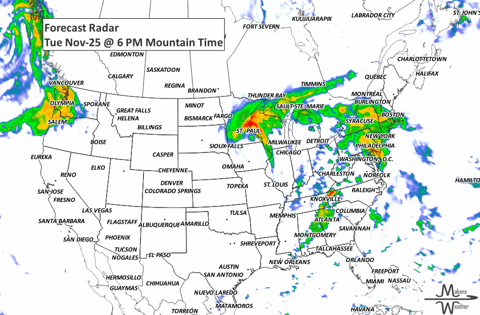
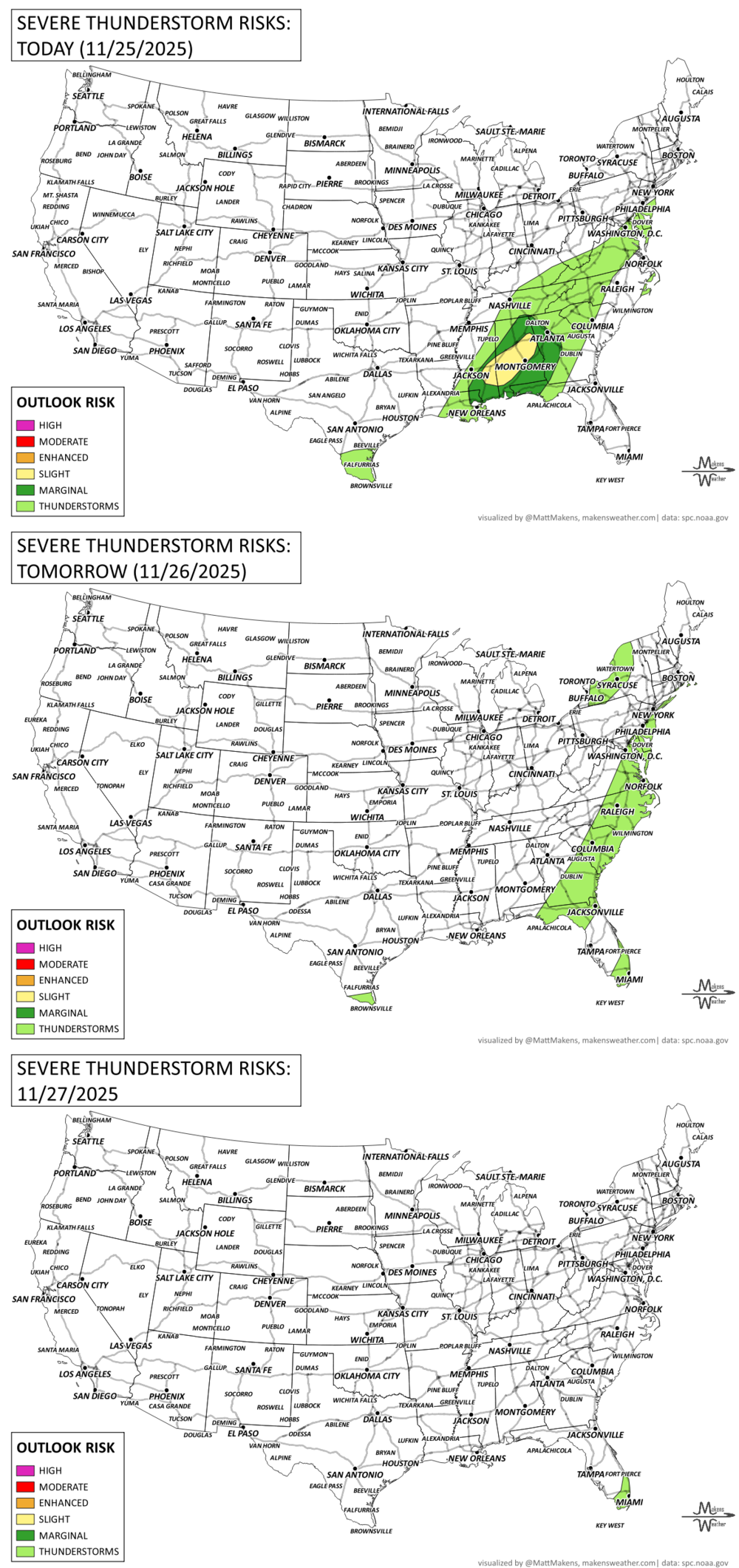
Tuesday (Nov 25): Rain changes to heavy snow across the northern Plains and Upper Midwest, with strong winds. Severe storms move across the Deep South.
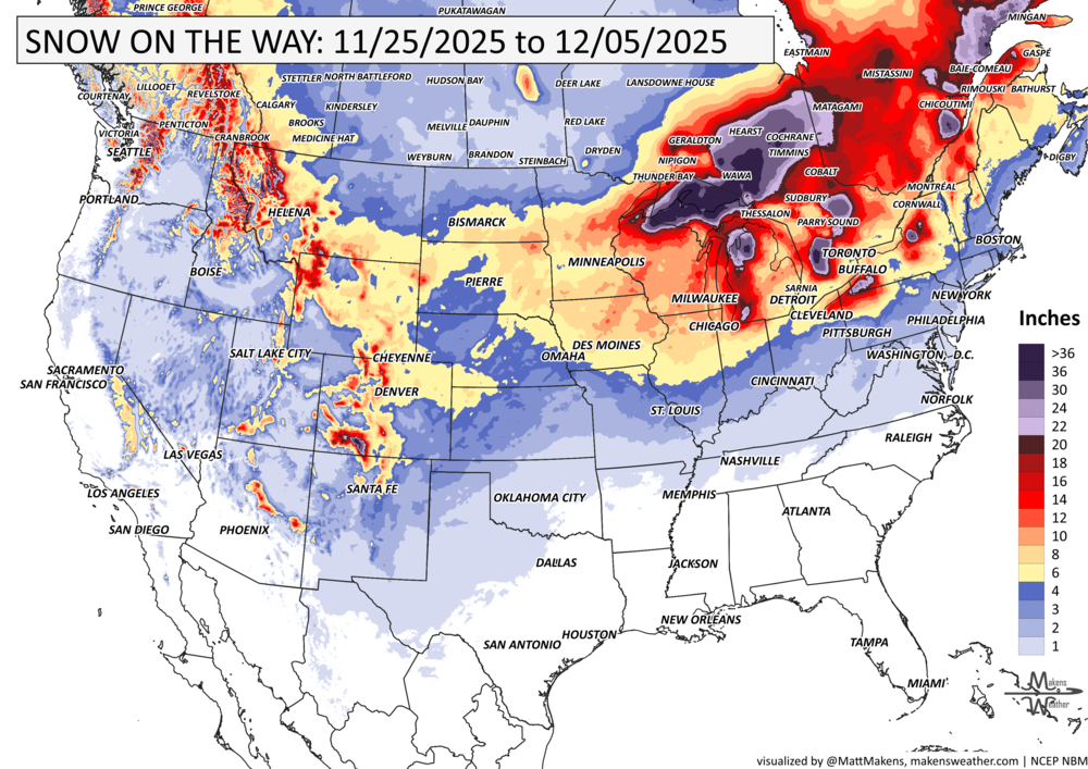
Wednesday (Nov 26): Lake-effect snow ramps up across the Upper Great Lakes. Snow spreads from Ontario into Quebec, with near-zero visibility and 15–60 cm of accumulation expected.
Thursday (Nov 27, Thanksgiving Day): Snow continues around the Great Lakes and Quebec. A strong cold front sweeps east with windy, colder conditions.
Friday (Nov 28): Cold air entrenches itself across the Eastern U.S., with highs 20 degrees colder than earlier in the week.
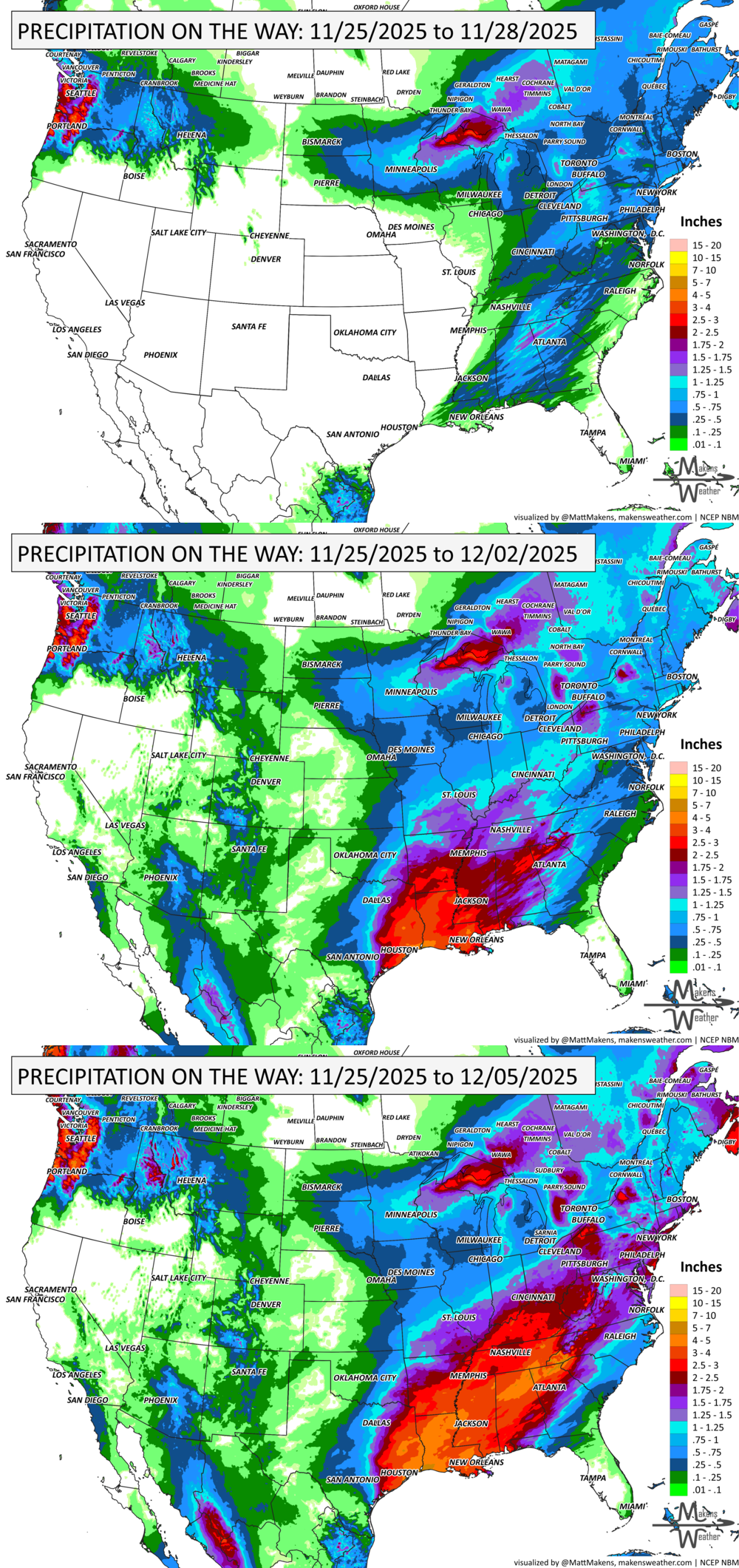
Weekend (Nov 29–30): Heavy lake-effect snow continues in Michigan and upstate New York. A new storm brings snow to the High Plains, Central Rockies, and possibly into the Midwest.
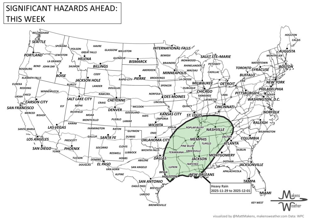
Early Next Week (Dec 1–2): More Gulf moisture triggers heavy rain and thunderstorms across the Lower Mississippi Valley. Arctic air deepens in the Northern Plains with subzero temps possible.
ON THE RADAR:
KEEP AN EYE TO THE SKY:
IN THE GAUGES:
GRAB A RULER:
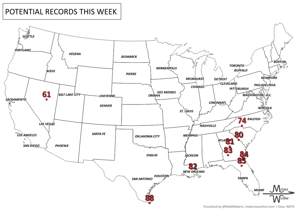
RECORDS MADE TO BE BROKEN:
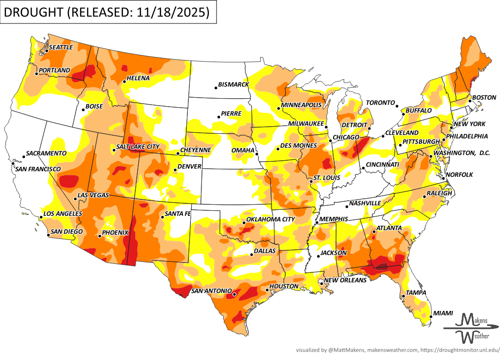
UN-DROUGHTABLY DRY:
Drought conditions worsened across much of the central and eastern U.S. this week due to continued dry weather, with notable degradations in Oklahoma, Texas, Louisiana, Florida, Georgia, and parts of the Great Lakes. Meanwhile, wetter conditions brought much-needed drought relief to California, Washington, and the Northeast, where rain and snow helped improve soil moisture and streamflow. In the West, widespread precipitation also benefited southern Nevada, the Sierra Nevada, and coastal California. Despite the improvements, short-term dryness is intensifying in parts of the central Plains and Montana, while Puerto Rico and Hawaii saw mixed changes based on localized rainfall. -U.S. Department of Agriculture
TROPICAL TIDINGS:
The tropics are quiet.
ARE YOU CIRRUS?!
1950 Michigan beat Ohio State 9-3 in the "Blizzard Bowl" in Columbus, OH. The morning temperature was 5 degrees with 40mph winds. Driving snow shrouded the players on the field.
1993 The Thanksgiving Day game between the Dallas Cowboys and Miami Dolphins was memorable because of the heavy sleet that covered the field at Texas Stadium during the game. Miami won the game with a score of 16 to 14.
2003 A deadly accident happened on Lake Mai-Ndombe in the Congo when a ferry broke apart during a terrible storm, killing 163 of the nearly 400 on board.
A drawn-out storm pattern will keep much of the country active through the first week of April. A slow-moving front stretching from the Great Lakes into the Plains will separate late-season snow and ice to the north from heavy rain and severe thunderstorms to the south. The setup brings the greatest impacts to parts of the Midwest, Ohio Valley, Southern Plains, Mississippi Valley, and eventually the East Coast, while the West sees mountain snow and then a warming trend heading into the weekend.