


Weekly Weather Watch: Tuesday, January 6th, 2026
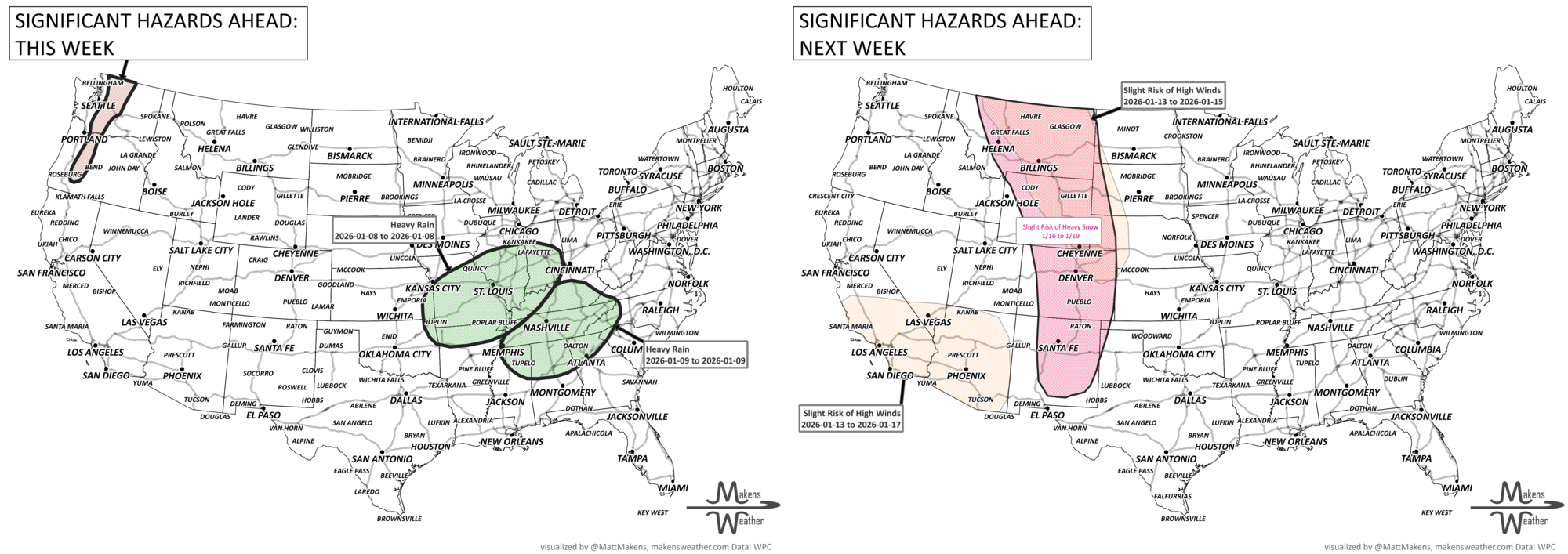
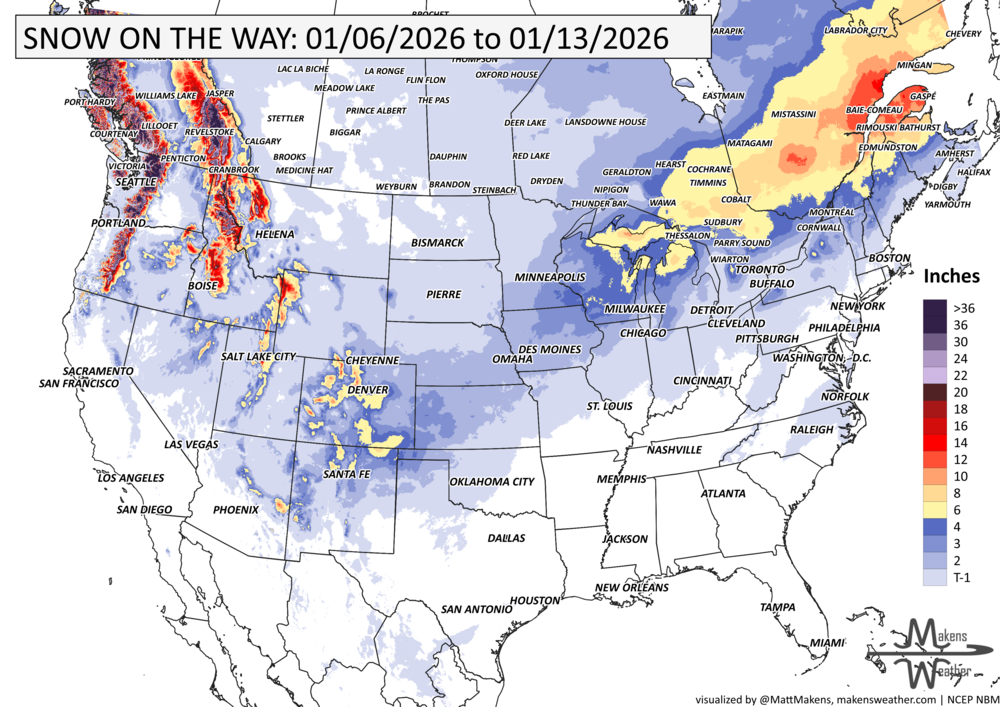
A powerful winter pattern is unfolding across the U.S. this week, with heavy snow blanketing the Cascades and northern Rockies into Alberta, a swath of freezing rain and snow from the Great Lakes to coastal Maine, including Ontario and Quebec, and record warmth building across the Central and Eastern U.S. The end of the week brings another potent storm system, a chance of bringing only the 3rd snowfall event this winter to Denver, and the potential for flooding rain in the Tennessee Valley and accumulating snow into the Upper Midwest.
Unlock the Makens Weather Advantage ☀️📊
Your membership includes:
✔️ Real-time dashboard with the latest weather observations and long-range projections
✔️ Monthly-lead forecasts to plan weeks ahead
✔️ Discounts on personalized consultations for ag, energy, or risk planning
All built for decision-makers who need weather insight, not just data.
🎯 Join now and put the forecast to work for you.
📈 The latest outlooks and conditions - track it 👉 Join Now to Access the Dashboard
HEADLINERS:
Weekly Timeline Snapshot
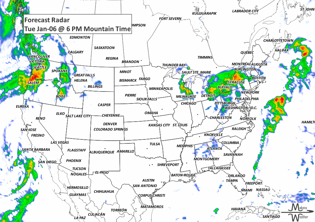
Tuesday (Jan 6):
Heavy mountain snow in the Cascades and northern Rockies into southern Alberta.
Freezing rain and light snow from the Upper Midwest to New England and across southern Ontario and Quebec.
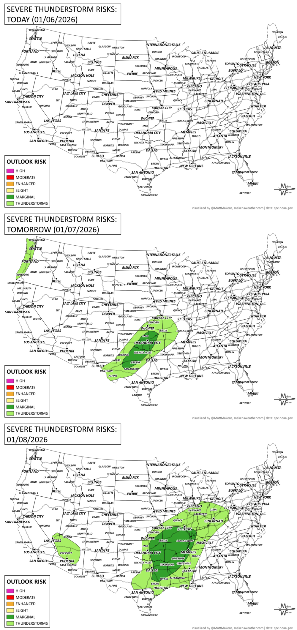
Wednesday–Thursday (Jan 7–8):
Lingering snow in northern New England.
Rain and storms build in the Desert Southwest, moving into the Southern Plains by Thursday.
Friday (Jan 9):
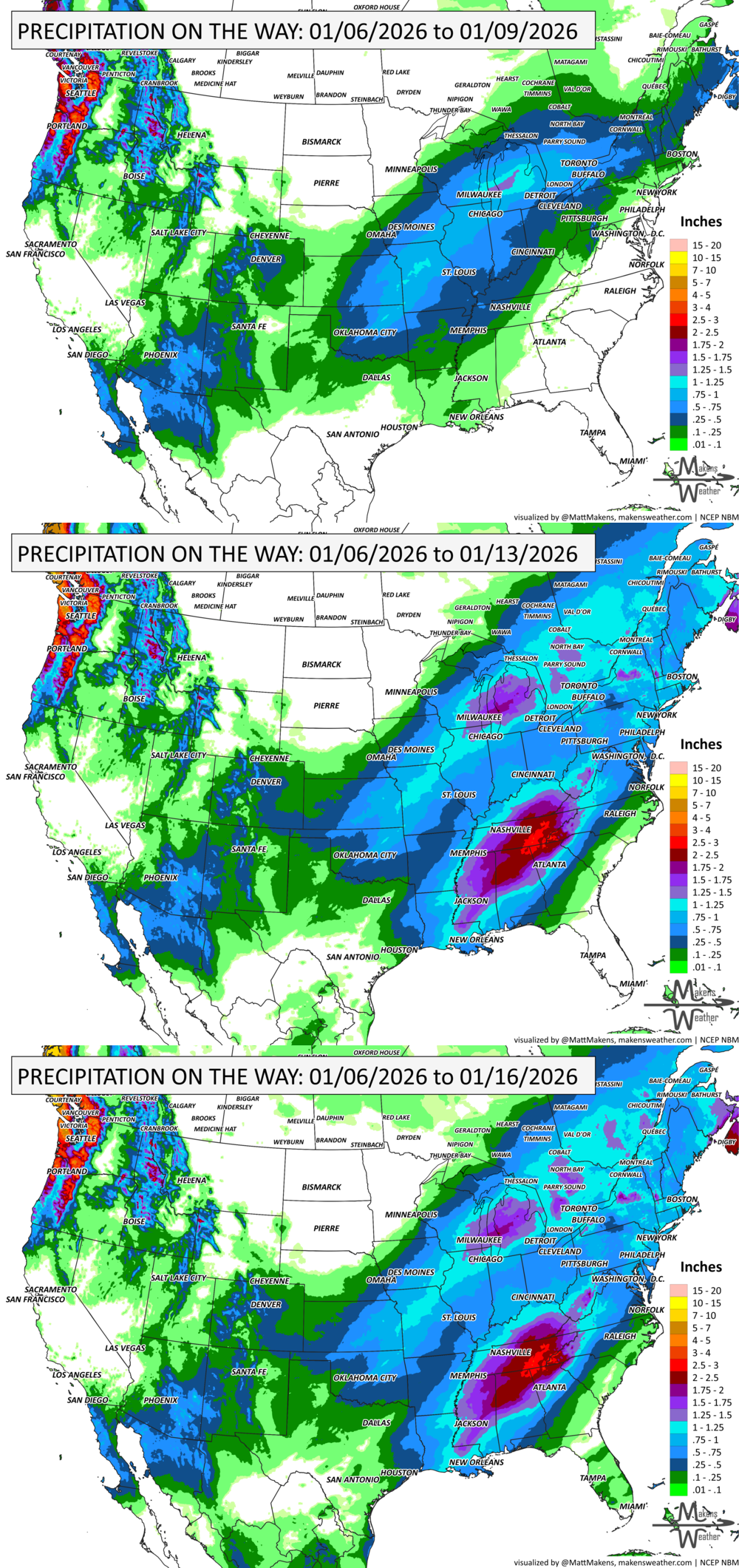
Flooding rain threat for the Tennessee Valley with 2 to 4" rainfall possible.
Snow potential from the Central Plains to Upper Midwest.
Record highs possible across the Southeast and Mid-Atlantic.
Weekend (Jan 10–11):
Storm exits East Coast with drier conditions nationwide.
Lake-effect snow possible downwind of the Great Lakes.
Early Next Week (Jan 12–13):
Mostly dry with potential for a new system into California or Pacific Northwest.
KEEP AN EYE TO THE SKY:
IN THE GAUGES:
GRAB A RULER:
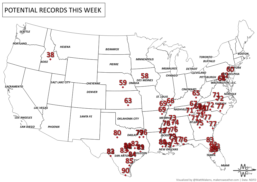
RECORDS MADE TO BE BROKEN:
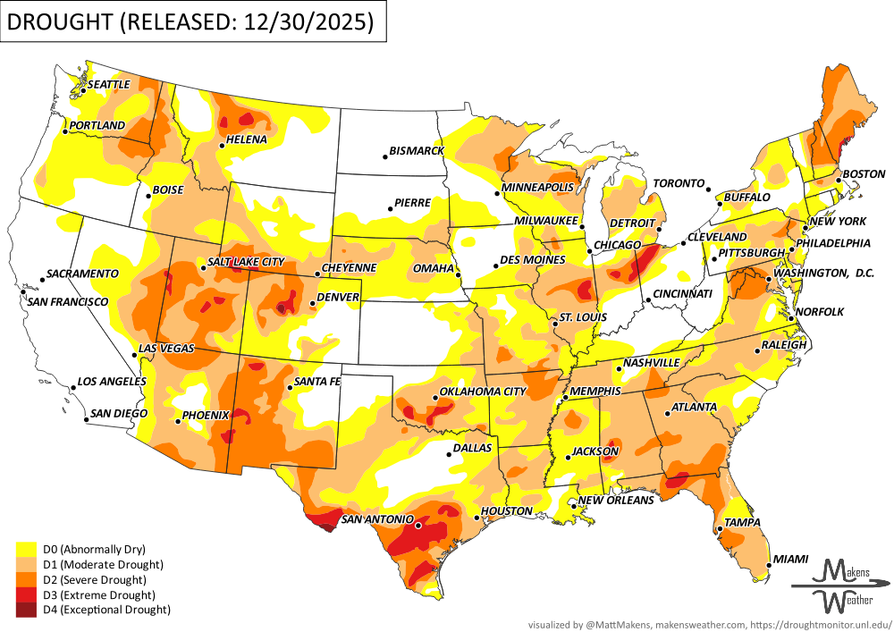
UN-DROUGHTABLY DRY:
A powerful heat dome brought record warmth to the central and southern U.S. over the holiday week, with highs 15–35°F above normal and the warmest Christmas Day on record for many. But by the weekend, a sharp winter storm flipped the pattern, delivering blizzard conditions and heavy snow to the Upper Midwest and Great Lakes, and ice impacts in the Northeast. While much of the country saw near-to-below-normal precipitation, California and parts of the West were drenched by a strong atmospheric river, with over 10 inches of rain and several feet of mountain snow. -U.S. Department of Agriculture
ARE YOU CIRRUS?!
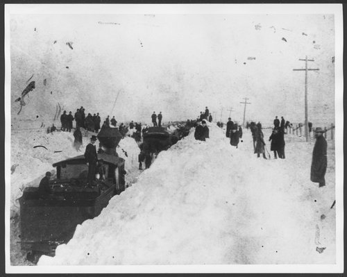
Today in weather history:
1996: A severe nor'easter paralyzed the East Coast from January 6 to the 8. In Washington D.C., this storm is also known as the "Great Furlough Storm" because it occurred during the 1996 federal government shutdown. Snowfall amounts from this event include 47 inches in Big Meadows, Virginia; 30.7" in Philadelphia; 27.8" in Newark; 24.6" at the Dulles International Airport; 24.2" in Trenton; 24" in Providence; 22.5" in Baltimore; 18.2" in Boston; 17.1" in D.C.; and 9.6" in Pittsburgh.
1886: The "Great Blizzard of 1886" struck the Midwest with high winds, subzero temperatures, and heavy snowfall. These conditions caused as many as 100 deaths, and 80% of the cattle in Kansas perished.
A drawn-out storm pattern will keep much of the country active through the first week of April. A slow-moving front stretching from the Great Lakes into the Plains will separate late-season snow and ice to the north from heavy rain and severe thunderstorms to the south. The setup brings the greatest impacts to parts of the Midwest, Ohio Valley, Southern Plains, Mississippi Valley, and eventually the East Coast, while the West sees mountain snow and then a warming trend heading into the weekend.